Showing 181 items matching "whittlesea road"
-
 Eltham District Historical Society Inc
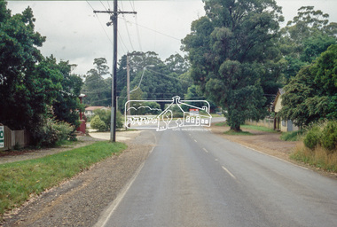
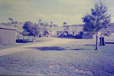
Slide - Photograph, Old Post Office, Whittlesea Road, Kinglake, c.June 1990
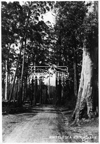
... Old Post Office, Whittlesea Road, Kinglake......Whittlesea Road...Eltham District Historical Society Inc 728 Main Rd Eltham melbourne roads Old Post Office Whittlesea Road Kinglake 35mm colour positive transparency (1 of 36) Mount - Agfa CS System grey 8 dots Old Post Office, Whittlesea Road, Kinglake Slide Photograph ...35mm colour positive transparency (1 of 36) Mount - Agfa CS System grey 8 dotsroads, old post office, whittlesea road, kinglake -
 Eltham District Historical Society Inc
Photograph, Whittlesea Road, Kinglake
... Whittlesea Road, Kinglake.......whittlesea road...It is significant in being the first community sourced collection representing the places and people of the Shire's first one hundred years. sepp shire of eltham pioneers photograph collection kinglake whittlesea road Digital image Whittlesea Road, Kinglake. ...Source: Mrs. McMinn, KinglakeThis photo forms part of a collection of photographs gathered by the Shire of Eltham for their centenary project book,"Pioneers and Painters: 100 years of the Shire of Eltham" by Alan Marshall (1971). The collection of over 500 images is held in partnership between Eltham District Historical Society and Yarra Plenty Regional Library (Eltham Library) and is now formally known as the 'The Shire of Eltham Pioneers Photograph Collection.' It is significant in being the first community sourced collection representing the places and people of the Shire's first one hundred years.Digital imagesepp, shire of eltham pioneers photograph collection, kinglake, whittlesea road -
 Eltham District Historical Society Inc
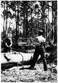
Photograph, Cutting log off, Whittlesea Road
... Cutting log off, Whittlesea Road.......whittlesea road...It is significant in being the first community sourced collection representing the places and people of the Shire's first one hundred years. sepp shire of eltham pioneers photograph collection kinglake whittlesea road Digital image Cutting log off, Whittlesea Road. ...Source: Mrs. McMinn, KinglakeThis photo forms part of a collection of photographs gathered by the Shire of Eltham for their centenary project book,"Pioneers and Painters: 100 years of the Shire of Eltham" by Alan Marshall (1971). The collection of over 500 images is held in partnership between Eltham District Historical Society and Yarra Plenty Regional Library (Eltham Library) and is now formally known as the 'The Shire of Eltham Pioneers Photograph Collection.' It is significant in being the first community sourced collection representing the places and people of the Shire's first one hundred years.Digital imagesepp, shire of eltham pioneers photograph collection, kinglake, whittlesea road -
 Eltham District Historical Society Inc
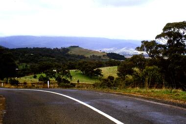
Slide - Photograph, Kinglake-Glenburn Road at Whittlesea-Kinglake Road, Kinglake, c.1993
... Kinglake-Glenburn Road at Whittlesea-Kinglake Road, Kinglake...Road...Whittlesea-Kinglake Road...Eltham District Historical Society Inc 728 Main Rd Eltham melbourne infrastructure roads kinglake Kinglake-Glenburn Road Whittlesea-Kinglake Road 35mm colour positive transparency Mount - Black and White Kinglake-Glenburn Road at Whittlesea-Kinglake Road, Kinglake Slide Photograph ...35mm colour positive transparency Mount - Black and Whiteinfrastructure, roads, kinglake, kinglake-glenburn road, whittlesea-kinglake road -
 Eltham District Historical Society Inc
Slide - Photograph, Whittlesea-Kinglake Road, Kinglake, c.1993
... Whittlesea-Kinglake Road, Kinglake...Road...Whittlesea-Kinglake Road...Eltham District Historical Society Inc 728 Main Rd Eltham melbourne infrastructure roads kinglake Kinglake Hotel Kinglake-Glenburn Road Whittlesea-Kinglake Road 35mm colour positive transparency Mount - Black and White Whittlesea-Kinglake Road, Kinglake Slide Photograph ...35mm colour positive transparency Mount - Black and Whiteinfrastructure, roads, kinglake, kinglake hotel, kinglake-glenburn road, whittlesea-kinglake road -
 Eltham District Historical Society Inc
Photograph, Kinglake opposite shops
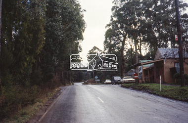
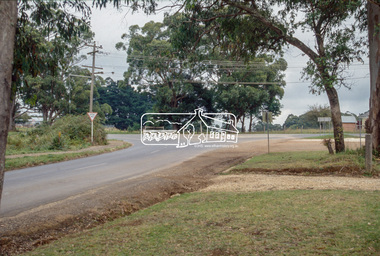
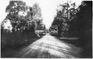
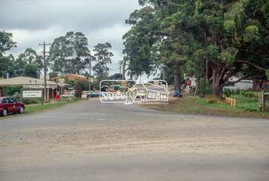
... ...kinglake whittlesea road...Two colour photographs of Kinglake-Whittlesea Road and area opposite Kinglake shops...Eltham District Historical Society Inc 728 Main Rd Eltham melbourne kinglake kinglake whittlesea road shops Two colour photographs of Kinglake-Whittlesea Road and area opposite Kinglake shops Kinglake opposite shops Photograph ...Two colour photographs of Kinglake-Whittlesea Road and area opposite Kinglake shopskinglake, kinglake whittlesea road, shops -
 Greensborough Historical Society
Slide - Photograph, John Ramsdale, Whittlesea to Wallan Road: Slide 89, 1990s
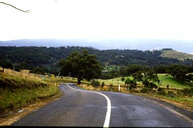
... Whittlesea to Wallan Road: Slide 89......whittlesea to wallan road...Photograph shows road and rural scene. this is the Whittlesea to Wallan Road north of Whittlesea....Greensborough Historical Society 34A Glenauburn Road Lower Plenty Lower Plenty melbourne Photograph shows road and rural scene. this is the Whittlesea to Wallan Road north of Whittlesea. ...Photograph shows road and rural scene. this is the Whittlesea to Wallan Road north of Whittlesea.Part of the John Ramsdale collection of slides and audio visual material.Colour photograph scanned from slide.No maker's marks. No caption on slide.whittlesea, wallan, whittlesea to wallan road -
 Eltham District Historical Society Inc
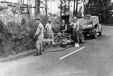
Photograph, Whittlesea-Kinglake Road Patrol Gang, April 1961
... Whittlesea-Kinglake Road Patrol Gang, April 1961.......whittlesea-kinglake road...It is significant in being the first community sourced collection representing the places and people of the Shire's first one hundred years. sepp shire of eltham pioneers photograph collection kinglake whittlesea-kinglake road road gang Digital image Whittlesea-Kinglake Road Patrol Gang, April 1961. ...Mrs. McMinn, Kinglake and Country Roads Board, Neg. No. 60-1034This photo forms part of a collection of photographs gathered by the Shire of Eltham for their centenary project book,"Pioneers and Painters: 100 years of the Shire of Eltham" by Alan Marshall (1971). The collection of over 500 images is held in partnership between Eltham District Historical Society and Yarra Plenty Regional Library (Eltham Library) and is now formally known as the 'The Shire of Eltham Pioneers Photograph Collection.' It is significant in being the first community sourced collection representing the places and people of the Shire's first one hundred years.Digital imagesepp, shire of eltham pioneers photograph collection, kinglake, whittlesea-kinglake road, road gang -
 Eltham District Historical Society Inc
Photograph, Whittlesea-Kinglake Road near "Tommy's Hut", 13 April 1905
... Whittlesea-Kinglake Road near "Tommy's Hut", 13 April 1905......whittlesea-kinglake road...It is significant in being the first community sourced collection representing the places and people of the Shire's first one hundred years. sepp shire of eltham pioneers photograph collection kinglake whittlesea-kinglake road Digital image Whittlesea-Kinglake Road near "Tommy's Hut", 13 April 1905 Photograph ...Country Roads Board, Neg. No. 30-25This photo forms part of a collection of photographs gathered by the Shire of Eltham for their centenary project book,"Pioneers and Painters: 100 years of the Shire of Eltham" by Alan Marshall (1971). The collection of over 500 images is held in partnership between Eltham District Historical Society and Yarra Plenty Regional Library (Eltham Library) and is now formally known as the 'The Shire of Eltham Pioneers Photograph Collection.' It is significant in being the first community sourced collection representing the places and people of the Shire's first one hundred years.Digital imagesepp, shire of eltham pioneers photograph collection, kinglake, whittlesea-kinglake road -
 Eltham District Historical Society Inc
Photograph, Kinglake near shops
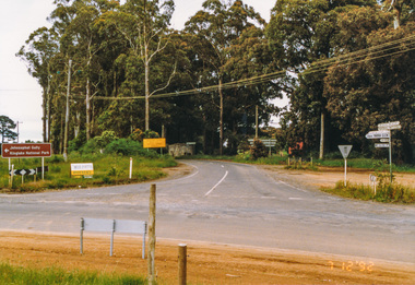
... ...kinglake whittlesea road...St Andrews Road, Kinglake on left; Toolangi Road to left before roundabout 2. Whittlesea Road on left with Kinglake Hotel 3....St Andrews Road, Kinglake on left; Toolangi Road to left before roundabout 2. Whittlesea Road on left with Kinglake Hotel 3. Kinglake near shops Photograph ...Three colour photographs showing the various road junctions near Kinglake shops. 1. St Andrews Road, Kinglake on left; Toolangi Road to left before roundabout 2. Whittlesea Road on left with Kinglake Hotel 3.kinglake, kinglake whittlesea road, hurstbridge road, kinglake healesville road -
 Eltham District Historical Society Inc
Slide - Photograph, Whittlesea-Kinglake Road, Kinglake, c.1993
... Whittlesea-Kinglake Road, Kinglake...Eltham District Historical Society Inc 728 Main Rd Eltham melbourne infrastructure roads healesville-kinglake road heidelberg-kinglake road kinglake kinglake-glenburn road 35mm colour positive transparency Mount - Black and White Whittlesea-Kinglake Road, Kinglake Slide Photograph ...35mm colour positive transparency Mount - Black and Whiteinfrastructure, roads, healesville-kinglake road, heidelberg-kinglake road, kinglake, kinglake-glenburn road -
 City of Whittlesea
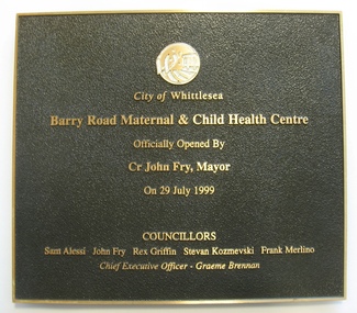
Plaque (item), City of Whittlesea Barry Road Maternal & Child Health Centre
... City of Whittlesea Barry Road Maternal & Child Health Centre...City of Whittlesea 25 Ferres Boulevard South Morang melbourne plaque plaque, colour, mounted, framed City of Whittlesea Barry Road Maternal & Child Health Centre Plaque Plaque ...plaque -
 Greensborough Historical Society
Slide - Photograph, John Ramsdale, Park and kiosk, Whittlesea: Slide 63, 1990s
... ...plenty road whittlesea...Photograph shows farm park and kiosk on Plenty Road Whittlesea. This is the future site of Funfields....Funfields plenty road whittlesea No maker's marks. No caption on slide. ...Photograph shows farm park and kiosk on Plenty Road Whittlesea. This is the future site of Funfields.Part of the John Ramsdale collection of slides and audio visual material.Colour photograph scanned from slide.No maker's marks. No caption on slide.funfields, plenty road whittlesea -
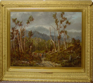 City of Whittlesea Art Collection
Painting - Oil on board, James Waltham Curtis, Road to Whittlesea, circa 1839 – 1901
... Road to Whittlesea...City of Whittlesea Art Collection 25 Ferres Boulevard South Morang whittlesea Road to Whittlesea Painting Oil on board James Waltham Curtis ...whittlesea -
 Eltham District Historical Society Inc
Photograph, Kinglake Shops
... ...kinglake whittlesea road...Eltham District Historical Society Inc 728 Main Rd Eltham melbourne kinglake shops kinglake whittlesea road Two colour photographs showing Kinglake shops Kinglake Shops Photograph ...Two colour photographs showing Kinglake shopskinglake, shops, kinglake whittlesea road -
 Eltham District Historical Society Inc
Slide - Photograph, Heidelberg-Kinglake Road, Kinglake, c.1993
... Road...Whittlesea-Kinglake Road...Eltham District Historical Society Inc 728 Main Rd Eltham melbourne infrastructure roads heidelberg-kinglake road kinglake Healesville-Kinglake Road Whittlesea-Kinglake Road 35mm colour positive transparency Mount - Black and White Heidelberg-Kinglake Road, Kinglake Slide Photograph ...35mm colour positive transparency Mount - Black and Whiteinfrastructure, roads, heidelberg-kinglake road, kinglake, healesville-kinglake road, whittlesea-kinglake road -
 Eltham District Historical Society Inc
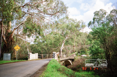
Photograph, Main Road junction, Kinglake, 7 December 1992, 07/12/1992
... road...whittlesea-kinglake road...Eltham District Historical Society Inc 728 Main Rd Eltham melbourne The Eltham Horse Trail: Research and Warrandyte to Kinglake: Survey of proposed route, December 1992: (3) Kangaroo Ground to Kinglake eltham horse trail (1992 survey) kinglake healesville-kinglake road heidelberg-kinglake road whittlesea-kinglake road Colour photograph Main Road junction, Kinglake, 7 December 1992 Photograph ...The Eltham Horse Trail: Research and Warrandyte to Kinglake: Survey of proposed route, December 1992: (3) Kangaroo Ground to KinglakeColour photographeltham horse trail (1992 survey), kinglake, healesville-kinglake road, heidelberg-kinglake road, whittlesea-kinglake road -
 Eltham District Historical Society Inc
Album - Photograph Album, J.A. McDonald, Bridge and Road Reconstruction Works, Shire of Eltham, 1952-1962
... Road construction...Rymers Corner...shire of eltham...Shire of Whittlesea...Research Oval Road construction Rymers Corner shire of eltham Shire of Whittlesea Silvan Road Bridge Silver Street Bridge silver street Sir Dallas Brooks Smedley property St Andrews Steels Creek Susan Street tarrawarra Tony Carberry Uniting Church Upper Yarra Dam Upper Yarra Reservoir W.E. ...J.A. McDonald produced this record in the course of his responsibilities as Shire Engineer for Eltham Shire Council.Record of various Shire of Eltham infrastructure works undertaken during the period of 1952-1962 involving bridge and road reconstruction projects, sometimes with Eltham Shire Council Project Reference numbers quoted. It was during this period that a number of significant improvements were made to roads and new bridges constructed within the shire that remain in place as of present day (2022). In many situations, the photos provide a tangible visible record of infrastructure that existed throughout the early days of the Shire. The album was put together by or under the direction of the Shire Engineer, J.A. McDonald.a. gillies, alistair knox park, benchmark studies, bend of islands, blease road, box hill state school, box hill teachers college, box hill tip, bridge construction, bridge street bridge, bridge, brisbane street, brougham steet, bulldozer, cecil street, charis pelling, cherry tree road, city of preston, cr. a. brinkkotter, cr. charis pelling, cranes, cromwell street, diamond creek (creek), diamond street, dixons creek bridge, dixon's creek road, drott, eltham leisure centre, eltham north, eltham police station, eltham, eltham-yarra glen road, f. wood, fitzsimons lane bridge, flat rock road, flood damage, floods, floodwater, footpaths and gutters, ford service garage, g. blair, garden hill, glen park bridge, glenauburn road, grand hotel, haldane road, healesville, healesville-yarra glen road, heidelberg-kinglake road, henley road bridge, henley road, hill property, hurstbridge water scheme, hurstbridge, hurstbridge-arthurs creek road, infrastructure, j. jolly, kangaroo ground, kangaroo ground-queenstown road, kangaroo ground-st andrews road, lilydale shire office, long gully bridge, long gully creek, long gully road, long gully, lower plenty bridge, lower plenty footbridge, lower plenty oval, lower plenty road, lower plenty, main road, methodist church, montmorency, mount pleasant road, new holland, old healesville road, opening ceremony, oxley bridge, para road, paul creek bridge, paul creek road, paul krafeznk, pinnacle lane, plaques, plenty river trail, plenty river, presbyterian church, prof donald thomson, pryor street, railway crossing, railway parade, rattray road, reconstruction works, reichelt avenue, research (vic.), research oval, road construction, rymers corner, shire of eltham, shire of whittlesea, silvan road bridge, silver street bridge, silver street, sir dallas brooks, smedley property, st andrews, steels creek, susan street, tarrawarra, tony carberry, uniting church, upper yarra dam, upper yarra reservoir, w.e. wolf, waterfall property, watsons creek, wattletree road bridge, wattletree road, wattletree road bridge, worlingworth, yarra glen, york street, yow yow creek -
 City of Whittlesea
Literary work - Manuscript - S. T. Grey, The History of the Formation of the Shire of Whittlesea, S.T. Grey, 1961
... The History of the Formation of the Shire of Whittlesea chronicles the establishment of the Darebin, Epping, Morang, Merriang and Whittlesea road districts and shires, and their eventual formation into the Shire of Whittlesea. ...City of Whittlesea 25 Ferres Boulevard South Morang melbourne The History of the Formation of the Shire of Whittlesea chronicles the establishment of the Darebin, Epping, Morang, Merriang and Whittlesea road districts and shires, and their eventual formation into the Shire of Whittlesea. ...The History of the Formation of the Shire of Whittlesea chronicles the establishment of the Darebin, Epping, Morang, Merriang and Whittlesea road districts and shires, and their eventual formation into the Shire of Whittlesea. It also includes stories about early pioneers, local institutions, buildings and a brief account of the development of local government in Victoria. The history was compiled at the direction of the Shire of Whittlesea in 1961, by Mr. S.T.Grey. Several of the items in the manuscript were published as articles in the Whittlesea Post in 1961.Manuscript, paper, carbon copied typed text -
 Melbourne Tram Museum
Legal record, Victorian Government, "Act of Parliament", 1/12/1978 12:00:00 AM
... Act of the Victorian Parliament to authorize the construction by the MMTB of an electric tramway in the City of Preston and the Shire of Diamond Valley and the Shire of Whittlesea in Plenty Road, to Settlement Road. Dated 5/12/1978...Melbourne Tram Museum 8 Wallen Road Hawthorn melbourne Trams tramways MMTB ACTs of Parliament New Tramway East Preston Plenty Rd Construction Act of the Victorian Parliament to authorize the construction by the MMTB of an electric tramway in the City of Preston and the Shire of Diamond Valley and the Shire of Whittlesea in Plenty Road, to Settlement Road. ...Act of the Victorian Parliament to authorize the construction by the MMTB of an electric tramway in the City of Preston and the Shire of Diamond Valley and the Shire of Whittlesea in Plenty Road, to Settlement Road. Dated 5/12/1978trams, tramways, mmtb, acts of parliament, new tramway, east preston, plenty rd, construction -
 Greensborough Historical Society
Slide - Photograph, John Ramsdale, Between Whittlesea and Upper Plenty: Slide 33, 1990s
... Photograph shows a country road between Whittlesea and Upper Plenty...Greensborough Historical Society 34A Glenauburn Road Lower Plenty Lower Plenty melbourne Photograph shows a country road between Whittlesea and Upper Plenty Part of the John Ramsdale collection of slides and audio visual material. whittlesea upper plenty No maker's marks. ...Photograph shows a country road between Whittlesea and Upper PlentyPart of the John Ramsdale collection of slides and audio visual material.Colour photograph scanned from slide.No maker's marks. No caption on slide.whittlesea, upper plenty -
 City of Whittlesea
Document - Correspondence, Council letter to Mrs Moses Thomas 1868, 1878
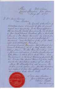
... In 1875, the area merged with the Whittlesea Road District to form the Shire of Whittlesea. ...In 1875, the area merged with the Whittlesea Road District to form the Shire of Whittlesea. ...In 1851 Moses Thomas purchased 400 acres, including a half mile frontage to the Plenty River, at Mernda (then known as Morang) where he operated a farm, inn and other business. In 1865 Moses Thomas was appointed Engineer, Clerk and Collector for the Morang District Road Board. In this role he would have been responsible for overseeing the collection of local property rates and the maintenance and construction of local roads and drains. Road District Boards were one of the earliest forms of local government in Victoria. The Morang or Upper Plenty Road District was established in 1862. It covered part of what is today Mernda, Doreen, South Morang, Mill Park and Bundoora. In 1875, the area merged with the Whittlesea Road District to form the Shire of Whittlesea. Moses Thomas briefly served as a Councillor with the Shire of Whittlesea until his death in 1878. Correspondence. Letter, paper, handwritten text with seal. Letter from James Ryan, Shire Secretary, Shire of Whittlesea to Mrs Moses Thomas on the death of Moses 18 May 1878. -
 Eltham District Historical Society Inc
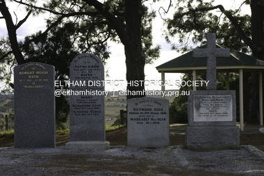
Photograph - Digital Photograph, Alan King, Reid family graves, Arthurs Creek Cemetery, 30 March 2008
... From 1868 he was a Whittlesea Roads Board member, then a shire councillor until shortly before his death in 1923 aged 88. ...From 1868 he was a Whittlesea Roads Board member, then a shire councillor until shortly before his death in 1923 aged 88. ...The Arthurs Creek Cemetery was originally the private cemetery of pioneers Agnes and Patrick Reid. Published: Nillumbik Now and Then / Marguerite Marshall 2008; photographs Alan King with Marguerite Marshall.; p11 The Hazel Glen property, at Middle Hut Road, Arthurs Creek, which includes one of Victoria’s earliest pioneer buildings, was the forerunner to the Arthurs Creek and Doreen townships. At one time the Doreen Post Office and school were called Hazel Glen. The Hazel Glen State School No 945, before it was moved to its present site, stood on land to the south of Chapel Lane, which had been donated by Hazel Glen owner, William Reid. In May 1895 the post office was renamed Doreen to avoid confusion with the Reid’s address. The Arthurs Creek Cemetery was originally the private cemetery of Hazel Glen pioneers Agnes and Patrick Reid. The Reids with their eight children, arrived in Melbourne in April 1839. In 1844 Patrick Reid took over the licence to the Stewart Ponds run of 5120 acres (2072ha). Reid renamed it Hazel Glen, after Hazelden, the name of the Reid estate at Mearns in Renfrewshire, Scotland. Reid built a small cottage from local stone and hand-made bricks, with walls one yard (91 cm) thick, a flagstone floor and a shingle roof. Today two rooms and a store room survive as part of a larger house. Agnes died in 1847 aged 49, and was buried on a hill overlooking Hazel Glen, where it is said she had asked to be buried as it had been a favourite picnic spot.2 In 1858 Patrick died aged 74, and was buried near her. Their son William was to become Whittlesea Shire’s first president. From 1868 he was a Whittlesea Roads Board member, then a shire councillor until shortly before his death in 1923 aged 88. In 1865 the Reid’s burial area was no longer on their property, so it was declared a cemetery site. In 1867 it became the Linton Public Cemetery, being in the Linton Parish. However, to avoid confusion with Linton near Ballarat, the cemetery was renamed the Arthurs Creek Public Cemetery in 1926. Arthurs Creek was named after Henry Arthur, a pastoralist and public servant, who ran 1000 sheep lower down the Creek, from 1836 to 1841. It is believed he built his home at the end of today’s Challenger Street in Diamond Creek.This collection of almost 130 photos about places and people within the Shire of Nillumbik, an urban and rural municipality in Melbourne's north, contributes to an understanding of the history of the Shire. Published in 2008 immediately prior to the Black Saturday bushfires of February 7, 2009, it documents sites that were impacted, and in some cases destroyed by the fires. It includes photographs taken especially for the publication, creating a unique time capsule representing the Shire in the early 21st century. It remains the most recent comprehenesive publication devoted to the Shire's history connecting local residents to the past. agnes reid, arthurs creek cemetery, nillumbik now and then (marshall-king) collection, patrick reid, reid family -
 Eltham District Historical Society Inc
Photograph, Monash Bridge, Arthurs Creek Road, Hurstbridge, Eltham Heritage Tour, 24 May 1992, 24/05/1992
... Next we drove to the North West boundary of the Shire at Masons Falls Road towards Whittlesea. On the way to the North East Boundary we passed St Peters, a yellow wooden Church with a Tudor Archway; built in the early 1920's in the style of the 1860's. ...Next we drove to the North West boundary of the Shire at Masons Falls Road towards Whittlesea. On the way to the North East Boundary we passed St Peters, a yellow wooden Church with a Tudor Archway; built in the early 1920's in the style of the 1860's. ...ELTHAM HERITAGE TOUR The Society excursion on 24th May 1992 was arranged by David Bick, leader of the team carrying out the Shire's heritage study. David selected a number of sites or buildings identified in the study, some of them lesser known components of the Shire's heritage. The tour commenced at the Eltham Shire Office at 10.00 am. Travel was by private car and mini-bus with stops at about twelve locations for commentary by David.It included a short walk in Hurstbridge and lunch at Kinglake. Highlights of the tour included: - 10 am Leave from Shire Offices - 3 Important Trees - A Physical Link to Eltham's First Settlers - Toorak Mansion Gates - A Surviving Farm House - An Intact Circa 1900 Main Street - First Settlers - Gold Miners, and Timber-getters - An Early Hotel - A Pioneering Homestead - Changing Eltham Shire - 20th Century - 4 pm Afternoon Tea and Finish Tour Extract from ELTHAM CULTURAL HERITAGE TOUR (Newsletter No. 85, July 1992, by Bettina Woodburn) "On the Arthurs Creek Road is a bridge designed by Monash, which we admired before walking across the little park with a mud-brick and timber shelter, to the Hurst family graveyard. There are two marked graves, one, Henry who was shot by Burke the bushranger and a cairn has a plaque listing others buried here from 1866 onwards. Burke was captured and tied to the wheel of a dray under the eucalypt near the waterhose/standpipe. Close by the kindergarten, at this place are three trees on the National Trust Register, a Canary Island pine, a Canadian cedar and probably a spruce. Radiata pines and a thick bolled peppercorn surround the little cemetery. Continuing along Main Street we notice elm trees planted as a war memorial, then on the left a 1930 timber house, a 1910 store and residence, resplendent with wrought iron trim, a double fronted Hardware Store and cypresses on the back alignment of a new vacant block. On the right side of the street is a less interesting attempt at an 'in character' shop. Further on are more early homes, one tucked away at the rear with two tall palms by the front steps. Another curiosity is a rounded veranda corner and there are more galvanised iron sheds or garages, before a mud-brick Dentist's Surgery. Beyond the round-a-about is St Peters Church, of mud-brick construction shared by Catholic and Anglican parishioners, overlooking the river flood plain. Leaving Hurstbridge on the Kinglake Road, we ate our picnic lunch beside the communication tower and enjoyed views of Melbourne, Yan Yean Reservoir and the distant Dandenongs beyond the spreading suburbs. Next we drove to the North West boundary of the Shire at Masons Falls Road towards Whittlesea. On the way to the North East Boundary we passed St Peters, a yellow wooden Church with a Tudor Archway; built in the early 1920's in the style of the 1860's. From the Healesville-Kinglake road the rolling hills had European aspects, the hedged fields and chestnut trees. Then it was back down the Hurstbridge Road through 'Aussie' bush of towering gums, with bracken and scrubby understorey, the Kinglake National Park, before more open country with deciduous trees planted in line, and a creek lined with willows."Record of the Society's history and activities and highlighting various aspects of the Heritage Study undertaken by David Bick used to create the future heritage overlay for the Shire of Eltham and later Nillumbik Shire.Roll of 35mm colour negative film, 4 stripsKodak Gold 100 5095shire of eltham historical society, activities, heritage tour, hurstbridge, monash bridge, arthurs creek road -
 Eltham District Historical Society Inc
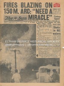
Newspaper - Newspaper articles, Sun News-Pictorial, Fires Blazing on 150M. Arc: "Need a Miracle", The Sun News-Pictorial, Tuesday, January 16, p1, 1962
... Road...Mt. Dandenong...Whittlesea...Andrews Postmaster Eltham Shire Secretary Max Watson Police Commissioner Porter Observatory Road Mt. Dandenong Whittlesea One Tree Hill Sassafras The Basin Steel’s Creek Ruby Ryan The Basin Progress Hall Yaallourn Yallourn North Stet Electricity Commission (S.E.C.) ...Various news articles pertaining to the January 1962 Victorian bushfires in the Dandenong and Healesville districts which by second day had spread on to a 150 mile front fromDaylesford and Kinglake through to the Dandenongs. Specific Eltham Shire districts mentioned include Ninka Road, St. Andrews, Kinglake, Hurstbridge on page 2 • Fires Blazing on 150M. Arc: "Need a Miracle", p1 (Illust.) – Victoria’s worst bushfire day since “Black Friday,” 1939 • Night dash as bushfire sweeps by, p2 (Illust.) • Kalorama Saved: Fire 100 Ft. Away, p2 • Stay away, says police chief, p2 • The Tragedy of the Fires, p3 (Illust.) • Good save by firemen, p4 (Illust.) • S.E.C. Firemen Saved N. Yallourn, p4 • Cherry river of flame, p4 • From the fire front: Fire-fighters are bitten by snakes, p4 • They faced the fury, p6 (Illust.) • The ’39 Blaze, p6 • They fought and failed, p6 • Hills Aflame: 2nd Day, pp16-17 (Illust.) • Respite at Olinda HQ, p16 (Illust.) • Here is Ruin, p17 (Illust.) • This fireman had to work among piled up furniture … p32 (Illust.) tom fielding collection, victorian bushfires - 1962, victorian bushfires – 1962, black friday, victorian bushfires – 1939, c.h. howe, daylesford, country fire authority, dandenongs, yallourn, central gippsland, montrose, olinda, kalorama, healesville, st. andrews, hurstbridge, ninka road, kinglake, yarra glen, a.l. mccutcheon, st. andrews postmaster, eltham shire secretary, max watson, police commissioner porter, observatory road, mt. dandenong, whittlesea, one tree hill, sassafras, the basin, steel’s creek, ruby ryan, the basin progress hall, yaallourn, yallourn north, stet electricity commission (s.e.c.), hernes oak, mcdonalds track, florence milkins, lieutenant-colonel k. leggett, bonza view road, ringwood police station, michael o’connor, volunteers, fire damage - buildings -
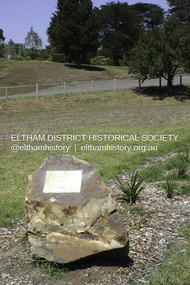 Eltham District Historical Society Inc
Photograph - Digital Photograph, Alan King, Memorial to Peter Brock, Ferguson's Paddock, Hurstbridge, 23 January 2008
... Road, Doreen, has been particularly active in local affairs. He was President of the Mernda Football Club (then Plenty Rovers), President of the Panton Hill Football League and he founded the Arthurs Creek and District Landcare Group. He also gave more than 50 years of service to the Whittlesea...Road, Doreen, has been particularly active in local affairs. He was President of the Mernda Football Club (then Plenty Rovers), President of the Panton Hill Football League and he founded the Arthurs Creek and District Landcare Group. He also gave more than 50 years of service to the Whittlesea ...Ferguson’s Paddock, Hurstbridge. A plaque on a boulder commemorates Peter Brock. Published: Nillumbik Now and Then / Marguerite Marshall 2008; photographs Alan King with Marguerite Marshall.; p167 On a rock in Ferguson’s Paddock, Hurstbridge, a plaque commemorates Peter Brock. It includes the words: ‘Boy from Hurstbridge without special privileges, grew to become champion of racetracks around the world but he never forgot his beginnings’. Brock came from a well-established local family. Born in Hurstbridge in 1945, he lived in Anzac Avenue as a child, attended the Hurstbridge Primary and Eltham High Schools and lived in the district most of his life. His father Geoff owned the Diamond Valley Speed Shop in Greensborough. Brock’s forbears were amongst the area’s earliest settlers. From Scotland, the Brocks arrived in Tasmania in 1830, to graze sheep. Family members moved to Sunbury, then Preston, grazing sheep in the Bundoora area. John Brock owned Janefield, possibly named after his wife. In 1855 he granted around two acres (0.8ha) of his estate for a school.1 In 1866 Lewis Brock bought 264 acres (107ha) in Nutfield, the first non-Aboriginal person to own that land. They planted an orchard, then from around 1935, Brock’s uncle Sandy and his grandfather Lewis, ran a dairy on the property. In the 1980s Brock and his then partner Bev, bought most of the property, which they sold after their separation in 2006. Brock’s father was a Hurstbridge Football Club President, but Brock’s uncle Sandy, of Brocks Road, Doreen, has been particularly active in local affairs. He was President of the Mernda Football Club (then Plenty Rovers), President of the Panton Hill Football League and he founded the Arthurs Creek and District Landcare Group. He also gave more than 50 years of service to the Whittlesea Agricultural Society, the Volunteers for Australian Football and the Doreen Rural Fire Brigade. Community service was important to Brock too. Brock, with his then partner Bev, established the Peter Brock Foundation in 1997, the year he retired from full-time V8 Supercar racing. The Foundation’s grants have included $100,000 towards the upgrade of a walking track in the Hurstbridge Parklands and other projects include a holiday house for the families of child cancer victims. Brother Lewis saw Brock as a spiritual person, who had a great affinity with people. He saw Brock as a role model of someone who could achieve their dreams. ‘The family didn’t have much money, yet that didn’t stop Peter realising his dreams. He was strong and didn’t let difficult times crush him.’ Despite his later successes, Brock’s most treasured trophy was for running 100 yards (91.4m)at his primary school in 1955, and he appreciated his head master Ted Griffiths’ encouragement of his sporting endeavours. At high school Brock became captain of Everard House. In his first year he bought a 1928 Austin 7 for £5. He cut the car into a box shape with an axe and enjoyed driving it – despite it having no brakes - at his grandparents’ farm at Nutfield. The turning point in Brock’s life came at age 23, when he built an Austin A30 in an old henhouse in Wattle Glen, using a Holden engine. He was laughed at until it won the Australian Sports Sedan Championship in 1968. Brock’s career then took off and he became a professional driver. Brock won Australian motor sport’s best-known event, the Bathurst 1000, nine times. Brock endured a bitter split from Holden in 1986 over control of his Holden-backed vehicle modification business and a car performance-enhancing device he called the ‘energy polariser’– despite it having no scientific evidence to support its claims. But Brock returned to Holden in 1994. Then in 1997, aged 52, Brock retired from fulltime V8 Supercar racing. However he continued to race at motor sport events. Brock won several awards, including an Order of Australia Medal in 1980, the Australian Sports Medal in 2000, and the Centenary Medal. On September 8, 2006, Brock died; after his car hit a tree during the Targa West Rally in Western Australia.This collection of almost 130 photos about places and people within the Shire of Nillumbik, an urban and rural municipality in Melbourne's north, contributes to an understanding of the history of the Shire. Published in 2008 immediately prior to the Black Saturday bushfires of February 7, 2009, it documents sites that were impacted, and in some cases destroyed by the fires. It includes photographs taken especially for the publication, creating a unique time capsule representing the Shire in the early 21st century. It remains the most recent comprehenesive publication devoted to the Shire's history connecting local residents to the past. nillumbik now and then (marshall-king) collection, ferguson's paddock, hurstbridge, peter brock memorial, peter brock -
 Eltham District Historical Society Inc
Journal, Peter Doughtery, ArtStreams: Whittlesea, Banyule, Darebin, Manningham, Nillumbik & Yarra; Vol. 9, No. 1, Mar-Apr 2004, 2004
... whittlesea community festival...Chris Smither...Mary Coughlan...Eliza Carthy...Alison Brown Quartet...music festivals...sushi wushi Eltham...Bundoora Homestead...Eltham Jazz Festival...marco luccio...warrandyte cafe...Clive Dickson...bahnhof cafe...Montsalvat...Eltham Fullife pharmacy...Nyora Road...." - Eltham District Historical Society Newsletter No. 161, March 2005 art streams city of whittlesea community festival Chris Smither Mary Coughlan Eliza Carthy Alison Brown Quartet music festivals sushi wushi Eltham Bundoora Homestead Eltham Jazz Festival marco luccio warrandyte cafe Clive Dickson bahnhof cafe Montsalvat Eltham Fullife pharmacy Nyora Road Gallery John Jenkins latrobe university poetry Ian McBryde Potters eltham gourmet poultry & game Eltham Wiregrass Gallery Bill Bachman Melanie Shanahan Neil Douglas Murrumbeena Collection Hurnall's Decorative Arts gallery st andrews hotel Leigh conkie Greensborough War memorial Park Sculptures il primo restaurant carlton bulleen art & garden centre Northcote pottery hurstbridge galleries Thompsons Amcal Pharmacy bendigo bank Hurstbridge & Districts Community Bank Branch Colour front and back cover with feature articles and literary pieces with photographs and advertisements printed in black and white. 36 pages, 30 cm. ...Vol. 9, No. 1, Mar-Apr 2004 CONTENTS Comment 2 Coming to a festival near you 3 Eltham Jazz and Blues Festival 7 Marco Luccio - printmaker, by Clive Dickson 8 Easy Living at Dizzy's by Odette Kelada 10 Reading Arcadia by John Jenkins 12 Poetry News by Ian McBryde 14 Local Colour - photography by Bill Bachman 16 Tributes to Melanie Shanahan 18 Nel Douglas & the Murrumbeena Connection 20 Book Reviews 22 CD Review 24 War Memorial Sculptures 25 Artin' About 26 Wining & Dining 30 Art Services and Classes 32 "Peter Dougherty has been involved in the local art scene for many years. As publisher and editor of the arts magazine Artstreams, his comments on the various branches of the arts are widely respected. His "The Arts" column in the Diamond Valley Leader presents a brief summary for a much wider cross section of the local community. Peter also operates his own gallery and the Artstreams Cafe at the St Andrews market. Peter has a wealth of knowledge about present day and historical aspects of local art and artists." - Eltham District Historical Society Newsletter No. 161, March 2005Colour front and back cover with feature articles and literary pieces with photographs and advertisements printed in black and white. 36 pages, 30 cm. Vol. 1, no. 1 (Nov. 1996) - Vol. 10, no. 5 (summer ed. 2005/06) art streams, city of whittlesea community festival, chris smither, mary coughlan, eliza carthy, alison brown quartet, music festivals, sushi wushi eltham, bundoora homestead, eltham jazz festival, marco luccio, warrandyte cafe, clive dickson, bahnhof cafe, montsalvat, eltham fullife pharmacy, nyora road gallery, john jenkins, latrobe university, poetry, ian mcbryde, potters, eltham gourmet poultry & game, eltham wiregrass gallery, bill bachman, melanie shanahan, neil douglas, murrumbeena collection, hurnall's decorative arts gallery, st andrews hotel, leigh conkie, greensborough war memorial park sculptures, il primo restaurant carlton, bulleen art & garden centre, northcote pottery, hurstbridge galleries, thompsons amcal pharmacy, bendigo bank, hurstbridge & districts community bank branch -
 Eltham District Historical Society Inc
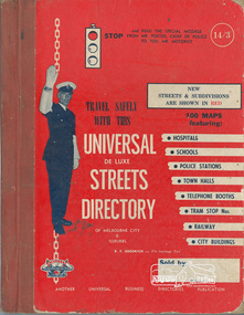
Book, Universal Business Directories (Aust.) Pty. Ltd, Universal De Luxe Streets Directory of Melbourne & Suburbs; Sixth Edition, 1960, 1960
... Eltham District Historical Society Inc 728 Main Rd Eltham melbourne melbourne maps Inside cover "Fhin McPhee Whittlesea" Hardback; xiv; 70 pages; 97 colour maps; 12 pages advertising including message on Road Safety by Chief Commissioner of Police Universal De Luxe Streets Directory of Melbourne & Suburbs; Sixth Edition, 1960 Book Universal Business Directories (Aust.) ...Hardback; xiv; 70 pages; 97 colour maps; 12 pages advertising including message on Road Safety by Chief Commissioner of Police Inside cover "Fhin McPhee Whittlesea"melbourne maps -
 Eltham District Historical Society Inc
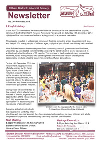
Newsletter, Eltham District Historical Society, Newsletter, No. 244 February 2019
... Contents: • A Playful History by Jim Connor • Our February Meeting • March Excursion – Return to Research • You May Notice • Early Days Recalled At Eltham (Eltham and Whittlesea Shires Advertiser, 21 Nov 1941, p4) • Montmorency Press association – 1927 (Advertiser, 12 Aug 1927, p4) • An Eltham Road (The Argus, 27 Jul 1911, p5) • An Eltham Old resident (Advertiser, 19 Aug 1932, p6) • Eltham Cemetery Stories by Richard Pinn • Contacts for the Eltham District Historical Society ...Eltham District Historical Society Inc 728 Main Rd Eltham melbourne Contents: • A Playful History by Jim Connor • Our February Meeting • March Excursion – Return to Research • You May Notice • Early Days Recalled At Eltham (Eltham and Whittlesea Shires Advertiser, 21 Nov 1941, p4) • Montmorency Press association – 1927 (Advertiser, 12 Aug 1927, p4) • An Eltham Road (The Argus, 27 Jul 1911, p5) • An Eltham Old resident (Advertiser, 19 Aug 1932, p6) • Eltham Cemetery Stories by Richard Pinn • Contacts for the Eltham District Historical Society The Shire of Eltham Historical Society was formed in October 1967. ...Contents: • A Playful History by Jim Connor • Our February Meeting • March Excursion – Return to Research • You May Notice • Early Days Recalled At Eltham (Eltham and Whittlesea Shires Advertiser, 21 Nov 1941, p4) • Montmorency Press association – 1927 (Advertiser, 12 Aug 1927, p4) • An Eltham Road (The Argus, 27 Jul 1911, p5) • An Eltham Old resident (Advertiser, 19 Aug 1932, p6) • Eltham Cemetery Stories by Richard Pinn • Contacts for the Eltham District Historical Society The Shire of Eltham Historical Society was formed in October 1967. The first newsletter of the Society was issued May 1978 and has been published continuously ever since on a bi-monthly basis. With the cessation of the Shire of Eltham in late 1994, the Society's name was revised to Eltham District Historical Society and this name first appeared with issue No. 103, July 1995. The collection of the Society's newsletters provides a valuable resource on the history of the Society's activities, office bearers and committee members, guest speakers and subjects of historical interest pertinent to the former Shire of Eltham and the Eltham District.A4 newsletter distributed to membersnewsletter, eltham district historical society -
 Eltham District Historical Society Inc
Photograph - Digital Photograph, Marguerite Marshall, Stuchbery Farm dairy, 14 March 2008
... Road, Yarrambat, to the east. Alan and Ada Stutchbery moved to the valley in 1890, first living in a tent where four children were born. Alfred built a home and outbuildings around 1896. They planted an orchard, then a market garden and developed a dairy. Published: Nillumbik Now and Then / Marguerite Marshall 2008; photographs Alan King with Marguerite Marshall.; p179 The dramatic steep-sided Plenty Gorge lies along the divide of two geological areas, and separates the Nillumbik Shire and the City of Whittlesea. ...Road, Yarrambat, to the east. Alan and Ada Stutchbery moved to the valley in 1890, first living in a tent where four children were born. Alfred built a home and outbuildings around 1896. They planted an orchard, then a market garden and developed a dairy. Published: Nillumbik Now and Then / Marguerite Marshall 2008; photographs Alan King with Marguerite Marshall.; p179 The dramatic steep-sided Plenty Gorge lies along the divide of two geological areas, and separates the Nillumbik Shire and the City of Whittlesea. ...Stuchbery Farm was situated on the Plenty River bounded by Smugglers Gully to the north and La trobe Road, Yarrambat, to the east. Alan and Ada Stutchbery moved to the valley in 1890, first living in a tent where four children were born. Alfred built a home and outbuildings around 1896. They planted an orchard, then a market garden and developed a dairy. Published: Nillumbik Now and Then / Marguerite Marshall 2008; photographs Alan King with Marguerite Marshall.; p179 The dramatic steep-sided Plenty Gorge lies along the divide of two geological areas, and separates the Nillumbik Shire and the City of Whittlesea. On the Nillumbik side are undulating hills and sedimentary rock, and in Whittlesea, lies a basalt plain formed by volcanic action up to two million years ago. This provides the Plenty Gorge Park with diverse vegetation and habitats, making it one of Greater Melbourne’s most important refuges for threatened and significant species. The park, established in 1986, consists of around 1350 hectares, and extends 11 kilometres along the Plenty River, from Greensborough to Mernda. It provides a wildlife corridor for around 500 native plant and 280 animal species. The area’s plentiful food and water attracted the Wurundjeri Aboriginal people and then European settlers. By 1837 squatters had claimed large runs of land for their sheep and cattle. The Plenty Valley was among the first in the Port Phillip District to be settled - mainly in the less heavily timbered west - and was proclaimed a settled district in 1841. But by the late 1880s, the settlers’ extensive land clearing for animal grazing, then agriculture, depleted the Wurundjeri’s traditional food sources, which helped to drive them away. Many Wurundjeri artefacts remain (now government protected), and so far 57 sites have been identified in the park, including scarred trees, burial areas and stone artefacts. Pioneer life could be very hard because of isolation, flooding, bushfires and bushrangers. Following the Black Thursday bushfires of 1851, basalt was quarried to build more fire-resistant homes. Gold discoveries in the early 1850s swelled the population, particularly around Smugglers Gully; but food production made more of an impact. In the late 1850s wheat production supplanted grazing. In the 1860s the government made small holdings available to poorer settlers. These had the greatest effect on the district, particularly in Doreen and Yarrambat, where orchards were established from the 1880s to 1914. Links with a prominent early family are the remains of Stuchbery Farm, by the river’s edge bounded by Smugglers Gully to the north and La Trobe Road, Yarrambat, to the east. The Stuchberys moved to the valley in 1890, and the family still lives in the area. In 1890, Alfred and Ada first lived in a tent where four children were born, then Alfred built the house and outbuildings around 1896. They planted an orchard, then a market garden, and developed a dairy. The family belonged to the local Methodist and tennis communities. Their grandson Walter, opened the Flying Scotsman Model Railway Museum in Yarrambat, which his widow, Vi, continues to run. Wal was also the Yarrambat CFA Captain for 22 years until 1987. Walter sold 24 hectares in 1976 for development - now Vista Court - and in 1990, the remaining 22.6 hectares for the park. Remaining are an early stone dairy and remnants of a stone barn, a pig sty and a well. Until it was destroyed by fire in 2003, a slab hut stood on the Happy Hollow Farm site, at the southern end of the park. The hut is thought to have been built in the Depression around 1893. This was a rare and late example of a slab hut with a domestic orchard close to Melbourne. Emmet Watmough and his family first occupied the hut, followed by a succession of families, until the Bell family bought it around 1948. There they led a subsistence lifestyle for 50 years, despite encroaching Melbourne suburbia. The Yellow Gum Recreation Area includes the Blue Lake, coloured turquoise at certain times of the year. Following the 1957 bushfires, this area was quarried by Reid Quarries Pty Ltd for Melbourne’s first skyscrapers, then by Boral Australia. However in the early 1970s water began seeping into the quarry forming the Blue Lake and the quarry was closed. The State Government bought the site in 1997 and opened it as a park in 1999.This collection of almost 130 photos about places and people within the Shire of Nillumbik, an urban and rural municipality in Melbourne's north, contributes to an understanding of the history of the Shire. Published in 2008 immediately prior to the Black Saturday bushfires of February 7, 2009, it documents sites that were impacted, and in some cases destroyed by the fires. It includes photographs taken especially for the publication, creating a unique time capsule representing the Shire in the early 21st century. It remains the most recent comprehenesive publication devoted to the Shire's history connecting local residents to the past. nillumbik now and then (marshall-king) collection, ada stuchbery, alan stuchbery, dairy, stuchbery farm, farm buildings, yarrambat, plenty gorge park