Showing 34 items matching "windermere"
-
 Federation University Historical Collection
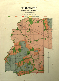
Map, Windermere, County of Grenville
... Windermere, County of Grenville...windermere...Coloured geological map of Windermere, County of Grenville. Scale is 40 chains to 1 inch...windermere grenville krause plan map Coloured geological map of Windermere, County of Grenville. ...Coloured geological map of Windermere, County of Grenville. Scale is 40 chains to 1 inchwindermere, grenville, krause, plan, map -
 City of Ballarat Libraries
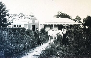
Photograph - Card Box Photographs, 'Hillview' Windermere. Home of the Harding family circa 1905
... 'Hillview' Windermere. Home of the Harding family circa 1905.......Windermere...Hillview Elizabeth Harding Helen Harding Windermere Building Private Dwelling Persons Garden 'Hillview' Windermere. ...The Harding's lived at 'Hillview' from 1860-1940. The women pictured are Elizabeth & Helen Harding.hillview, elizabeth harding, helen harding, windermere, building, private dwelling, persons, garden -
 Embroiderers Guild, Victoria
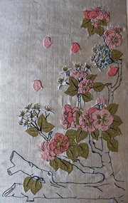
Textile - Art Nouveau Panel, 1900-20
... Handmade material woven and embroidered by donor when at the Windermere School of Embroidery, England....Windermere, England...Handmade material woven and embroidered by donor when at the Windermere School of Embroidery, England. Embroidery Panel 1900-20 England Silk Embroidery European Hand woven yellow cotton warp and a blue silk weft thread. ...Handmade material woven and embroidered by donor when at the Windermere School of Embroidery, England.Hand woven yellow cotton warp and a blue silk weft thread. The embroidered apple blossom is worked in laid stitch with a heavy twisted thread. Also sprays of blue based flowers with green stamens.embroidery, panel, 1900-20, england, silk embroidery, european -
 City of Ballarat Libraries
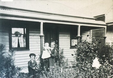
Photograph - Card Box Photographs, 412 Windermere Street, Ballarat 1904
... 412 Windermere Street, Ballarat 1904....City of Ballarat Libraries Eureka Centre Eureka Street Ballarat East goldfields This photo shows Mrs Parry and children, Marjery and David, who would later become a plumber. Windermere Street Ballarat Marjery Parry David Parry building house garden private dwelling 412 Windermere Street, Ballarat 1904. ...This photo shows Mrs Parry and children, Marjery and David, who would later become a plumber.windermere street, ballarat, marjery parry, david parry, building, house, garden, private dwelling -
 City of Ballarat Libraries
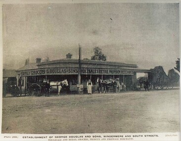
Postcard - Card Box Photographs, Establishment of George Douglas and Sons, Windermere and South Streets. Ballarat
... Establishment of George Douglas and Sons, Windermere and South Streets. Ballarat....George Douglas and Sons Windermere Street South Street Building Shop Establishment of George Douglas and Sons, Windermere and South Streets. ...Wholesale and Retail Grocers, Produce and Firewood Merchants. Plate 269 Chuck Photo Series.george douglas and sons, windermere street, south street, building, shop -
 Department of Health and Human Services
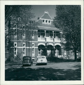
Photograph, 2 cars - An Austin & an early model Holden parked on Windermere St., outside Ballarat Base Hospital 13/02/1959 - Regional & District Hospital Collection - Department of Health & Human Services (DHHS)
... 2 cars - An Austin & an early model Holden parked on Windermere St., outside Ballarat Base Hospital 13/02/1959 - Regional & District Hospital Collection - Department of Health & Human Services (DHHS)...Department of Health and Human Services 50 Lonsdale St Melbourne melbourne Photo is part of the Department of Health, Building & Services Division, Facilities Development - Hospitals - Photographic Inventory 2 cars - An Austin & an early model Holden parked on Windermere St., outside Ballarat Base Hospital 13/02/1959 - Regional & District Hospital Collection - Department of Health & Human Services (DHHS) Photograph ...Photo is part of the Department of Health, Building & Services Division, Facilities Development - Hospitals - Photographic Inventory -
 Thompson's Foundry Band Inc. (Castlemaine)
Sheet Music, Windermere
... Windermere...(Castlemaine) 347 Barker Street Castlemaine goldfields Windermere Sheet Music ... -
 Learmonth and District Historical Society Inc.
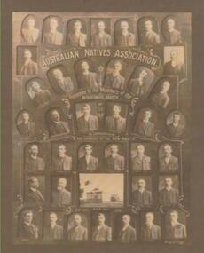
Photo, Richards & Co, Australian Natives Asociation.Windermere Branch no 53, Circa 1908
... These photos were taken and put together to commemorate the opening of the new Hall of the Windermere Bran ch no 53 of the ANA Association. 24th September 1908....Presented by the Members of the WINDERMERE BRANCH No 53.TO COMMEMORATE THE OPENING OF THE NEW HALL.Sept 24th 1908. ...(row 7 ),M.Baird (Mathew), H.Cox, F.Powell, W.McKartney, W.Wilkins, R.Charles, H.Birkett. windermere ana hall 1908.windermere branch no 53. ...These photos were taken and put together to commemorate the opening of the new Hall of the Windermere Bran ch no 53 of the ANA Association. 24th September 1908.(from the top, row 1) C.Allen, A.Cox, F.White, T.Stewart, R.W.Charles, R.McKenzie, A.Cox. (row 2) W.Nesbitt, R.Walton, (row 3) D.F.Dickie T.Robinson, J.Robertson, D.Nippard, R.Kerr, W.J.Cox. (row 4) J.S.Feery, H.J.Taylor (Committee), G.White (ex President), S.Coles,(President), W.Harding (Vice President), E.Burrows. (row 5) A.Walker, P.Beaton,(Asisstant Secretary), F.Cox,(Secretary), D.Walton,(Treasurer), R.Harding, (Committee member), W.Walton (Committee member). (row 6) J.Hevey, F.Cox, (Trustee),J.M.Feery, (Committee member), D.Davidson, (Committee member). (row 7 ),M.Baird (Mathew), H.Cox, F.Powell, W.McKartney, W.Wilkins, R.Charles, H.Birkett. Collection of photos set in a dark wooden frame, with "gilt" decoration on inner edge and gold coloured inner frame edge. the photos are on a dark brown cardboard mount. AUSTRALIAN NATIVES ASSOCIATION. Presented by the Members of the WINDERMERE BRANCH No 53.TO COMMEMORATE THE OPENING OF THE NEW HALL.Sept 24th 1908. (under photo ANA Hall) windermere ana hall 1908.windermere branch no 53. -
 Federation University Historical Collection
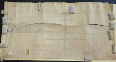
Plan, Lal Lal Iron Company Steam Engine Plan, 1880s, 1880s
... Watson Prectical Mechanical Engineer Draughtsman Windermere St Ballarat...Watson Prectical Mechanical Engineer Draughtsman Windermere St Ballarat Large original plan of an engine of the Lal Lal Iron Company. ...Large original plan of an engine of the Lal Lal Iron Company. Note, this item is in fragile condition and can only be viewed exceptional circumstance. Digital image details are available "W. Watson Prectical Mechanical Engineer Draughtsman Windermere St Ballaratw. watson, lal lal, lal lal blast furnace, lal lal iron company, steam engine, lal lal iron company steam engine, plan, engineering drawing -
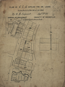 Federation University Historical Collection
Plan, Lease Applied for by R.M. Serjeant, c1890, c1890
... Plan of a lease showing streets around Skipton and Windermere Streets, Redan. Scale 4 chains to 1 inch (!...Barker Library (top floor) Mount Helen goldfields serjeant r.m.serjeant robert m. serjeant george street skiptn street windermere stret rubicon stret cobdon street ascot street lease redan ballarat robert malachi serjeant band of Hope and Albion mine Plan of a lease showing streets around Skipton and Windermere Streets, Redan. ...Plan of a lease showing streets around Skipton and Windermere Streets, Redan. Scale 4 chains to 1 inch (!:3168)serjeant, r.m.serjeant, robert m. serjeant, george street, skiptn street, windermere stret, rubicon stret, cobdon street, ascot street, lease, redan, ballarat, robert malachi serjeant, band of hope and albion mine -
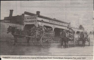 Bendigo Historical Society Inc.
Newspaper - JENNY FOLEY COLLECTION: THIRSTY
... Thirsty: wood carts outside the original Windermere hotel, Camp Street, Kangaroo Flat, circa 1922....Thirsty: wood carts outside the original Windermere hotel, Camp Street, Kangaroo Flat, circa 1922. ...Bendigo Advertiser "The way we were" from 1999. Thirsty: wood carts outside the original Windermere hotel, Camp Street, Kangaroo Flat, circa 1922.newspaper, bendigo advertiser, the way we were -
 Ballaarat Mechanics' Institute (BMI Ballarat)
Windermere St
... ...Windermere...Please contact BMI for all print and usage inquiries. Ballarat Windermere Windermere St ...This photograph is from the Max Harris Collection held by the Ballaraat Mechanics' Institute. Please contact BMI for all print and usage inquiries.ballarat, windermere -
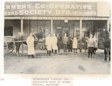 Beaufort Historical Society
Photograph - Beaufort Buildings, Burumbeet Farmers Co-operative
... Burumbeet and Windermere Farmers Co-operative Society opened its' Beaufort Store in 1923. ...Beaufort Historical Society 9 Livingstone st Beaufort 3373 Burumbeet and Windermere Farmers Co-operative Society opened its' Beaufort Store in 1923. ...Burumbeet and Windermere Farmers Co-operative Society opened its' Beaufort Store in 1923. The building was located at the corner of Burke and King Streets Beaufort - the current location of Day's Plumbing.Black and White Photograph showing people outside the storebeaufort, beaufort business -
 Linton Mechanics Institute and Free Library Collection
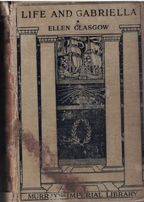
Book - Novel, Glasgow, Ellen, Life and Gabriella : the story of a woman's courage, 1916
... Reading Room: 1017 Sturt Street (Between Ascot 7 Windermere Sts) etc'; 'Murray's Imperial Library London'; 'Australian Red Cross Society'...Reading Room: 1017 Sturt Street (Between Ascot 7 Windermere Sts) etc'; 'Murray's Imperial Library London'; 'Australian Red Cross Society' 529p. : beige cover with black decoration Life and Gabriella : the story of a woman's courage Book Novel Glasgow, Ellen John Murray The Country Life Press ...Gabriella is a young woman from a good family who has fallen on hard times. Forced to get a job that puts her between social groups, Gabriella embarks on a treacherous journey through the social strata of turn-of-the-century Richmond, Virginia529p. : beige cover with black decorationfictionGabriella is a young woman from a good family who has fallen on hard times. Forced to get a job that puts her between social groups, Gabriella embarks on a treacherous journey through the social strata of turn-of-the-century Richmond, Virginiafiction, romance, ellen glasgow -
 Ballaarat Mechanics' Institute (BMI Ballarat)
From Base Hospital 1868 Windermere St
... ...Windermere...Ballarat base hospital 1868 Windermere From Base Hospital 1868 Windermere St ...This photograph is from the Max Harris Collection held by the Ballaraat Mechanics' Institute. Please contact BMI for all print and usage inquiries.ballarat, base hospital, 1868, windermere -
 Federation University Historical Collection
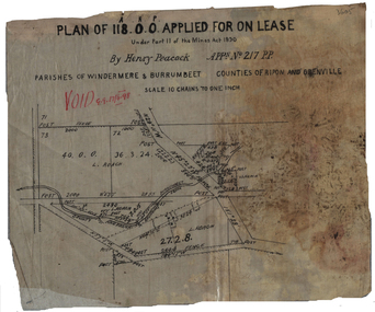
Plan, Henry Peacock's Lease, 1898, 1898
... ...windermere...Barker Library (top floor) Mount Helen goldfields henry peacock mining lease l. roach windermere burrumbeet Plan on linen of Henry Peacoack's application for a lease. ...Plan on linen of Henry Peacoack's application for a lease. Scale: 10 chains to 1 inch (1:7920)henry peacock, mining lease, l. roach, windermere, burrumbeet -
 Federation University Historical Collection
Photograph - Photograph - Black and White, Eden Studio, Horne and Watson Families
... They lived in a small cottage in Windermere Street, Ballarat....They lived in a small cottage in Windermere Street, Ballarat. Hilda Horne Hilda Watson Eva Watson Emma Jacka Emma Watson Eden Studio The Yeoman Studios Yeoman & Co .1 Verso: upper Hilda 1910 Horne; Jack in pencil (her brother John Richard Watson) .2 Verso: upper L - The Yeoman Studios ; C- POST CARD; R - postage stamp outline. ...Hilda Horne (b 06/05/1888 in Yendon) was the 10th child of Thomas William Watson and Emma Eliza Jane Phillips (who was one of the first white children born in the Barrabool Hills area (Geelong). Thomas worked on the Victorian Railways and was stationed at Yendon where they acquired a small farmlet named Graceland. Hilda married George Horne in. They lived in a small cottage in Windermere Street, Ballarat.Three black and white photographs of the Horne family .1 Hilda Horne b Watson 06/05/1888 at Yendon, the daughter of Thomas William and Emma Eliza Jane (b Phillips)Watson. .2 Three Watson sisters - Emma Jacka b Watson 30/08/1866 - 03/04/1904, died in childbirth in South Africa (standing); Hilda Horne b Watson 06/05/1888 (seated L); Eva Watson b 4/06/1890 - 08/07/1959 (seated R) married Leo Wise. .3 George Horne aged 6 months, married Hilda Watson..1 Verso: upper Hilda 1910 Horne; Jack in pencil (her brother John Richard Watson) .2 Verso: upper L - The Yeoman Studios ; C- POST CARD; R - postage stamp outline. CORRESPONDENCE / ADRESS ONLY LHS - handwritten "To Jack with love from Eva"; All Watson sisters; RHS Emma Batt( believe incorrect surname) Eva Watson Hilda Horne .3 Verso: Upper L - Eden Studios; C POST CARD; R - postage stamp outline CORRESPONDENCE / ADDRESS ONLY LHS - EDEN STUDIO Sturt Street Ballarat; handwritten in biro -George Horne; in pencil - Georgie 6 months hilda horne, hilda watson, eva watson, emma jacka, emma watson, eden studio, the yeoman studios, yeoman & co -
Kew Historical Society Inc
Plan - Saxonwood Estate, Doncaster [East]
... Undated, multi-page subdivision plan advertising lots for sale bounded by Blackburn Road, George Street, Windermere Avenue, and Saxonwood Drive in what is currently Doncaster East. ...Undated, multi-page subdivision plan advertising lots for sale bounded by Blackburn Road, George Street, Windermere Avenue, and Saxonwood Drive in what is currently Doncaster East. ...Subdivision plans and real estate flyers/brochures reveal a number of aspects of urban development and history. The Kew Historical Society's collection of these plans, as well as advertisements extracted from magazines, cover key aspects of community development and architectural history of Kew and Kew Eat as well as surrounding suburbs. While most of the plans in the collection were gifted to the Society by the former City of Kew, a number of other plans and advertisements have been donated by individuals, of which this is an example.Undated, multi-page subdivision plan advertising lots for sale bounded by Blackburn Road, George Street, Windermere Avenue, and Saxonwood Drive in what is currently Doncaster East. Other streets in the subdivision include: Mowbray Court, Stafford Court, Rugby Court, and Robin Hood Court. The front page includes a Birdseye view of the estate which identifies existing and projected civic amenities, as well as the estate's relationship to surrounding suburbs and the city centre. Red crosses on the detailed plan of lots on page two indicate those that have been sold. The final page includes a locality plan. saxonwood estate -- doncaster east (vic.), subdivision plans -- doncaster east (vic.) -
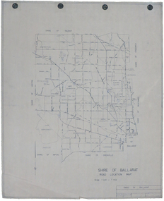 Federation University Historical Collection
Map, Shire of Ballarat Road Location Map, 1968, 05/06/2014
... ...windermere...Barker Library (top floor) Mount Helen goldfields ballarat shire of ballarat roads dowling forest lake burumbeet lake learmonth ascot windermere tourello White paper road location map. ...White paper road location map. Scale 1 mile to 1 inchballarat, shire of ballarat, roads, dowling forest, lake burumbeet, lake learmonth, ascot, windermere, tourello -
 Ballarat Tramway Museum
Slide - 27 mm sq slide/s - set of 5, Lilian Butler, Sturt Street, 1971
... Set of 5 AGFA slides - blue and white plastic mounts: 1 - Sturt St looking west, south side from Windermere St. .2 - ditto from Dawson St, shows tram stop sign and end of section sign. .3 - ditto from Armstrong St - with Myer's and Coles stores in the background. .4 - ditto at Ripon St, showing junction of View Point line, has the shelter on the right. .5 - City terminus - Sturt St and Lydiard St, with a bogie tram arriving from Grenville St. ...Ballarat Tramways trams Sturt St Dawson St Tram Stops View Point Shelters Lydiard St Set of 5 AGFA slides - blue and white plastic mounts: 1 - Sturt St looking west, south side from Windermere St. .2 - ditto from Dawson St, shows tram stop sign and end of section sign. .3 - ditto from Armstrong St - with Myer's and Coles stores in the background. .4 - ditto at Ripon St, showing junction of View Point line, has the shelter on the right. .5 - City terminus - Sturt St and Lydiard St, with a bogie tram arriving from Grenville St. ...Yields information about Sturt St between Lydiard St and Ripon St.Set of 5 AGFA slides - blue and white plastic mounts: 1 - Sturt St looking west, south side from Windermere St. .2 - ditto from Dawson St, shows tram stop sign and end of section sign. .3 - ditto from Armstrong St - with Myer's and Coles stores in the background. .4 - ditto at Ripon St, showing junction of View Point line, has the shelter on the right. .5 - City terminus - Sturt St and Lydiard St, with a bogie tram arriving from Grenville St. Has the ESCo switch box in the view - (to the right of the ladies). Has the Commonwealth Bank on the right hand side of the photo. Photo from the collection of Lilian Butler. ballarat, tramways, trams, sturt st, dawson st, tram stops, view point, shelters, lydiard st -
 Ballarat Tramway Museum
Photograph - Black & White Photograph/s - set of 3, Chris Phillips, 28/12/1967 12:00:00 AM
... Cars on Carlton Street loop, just outside the southern entrance to the Botanical Gardens" and in pencil "Christopher D Phillips, 113 Windermere Street Ballarat (053) 31 6075" and "12/1967" 358.2 - "44)" in top left hand corner, William F Scott address label in bottom right hand corner, trimming marks top and bottom. ...Cars on Carlton Street loop, just outside the southern entrance to the Botanical Gardens" and in pencil "Christopher D Phillips, 113 Windermere Street Ballarat (053) 31 6075" and "12/1967" 358.2 - "44)" in top left hand corner, William F Scott address label in bottom right hand corner, trimming marks top and bottom. ...Photo of two trams crossing each other at Carlton St loop, out of sequence running, normally crossed at Gardens loop Typical of the operation and the street scene at the time. The background trees were later removed.Bogie tram 36 and single trucker (20) crossing at Carlton St. Loop, early 1970's. View looking down track, towards south. No. 36 with Mt Pleasant destination, and No. 20 with Gardens via Sturt St. West on western track. Trees full with leaves. Note V crossing of frog, one made up by SEC? No. 20 has Twin Lakes sign under headlight. Image not square onto photo paper. 358.1 - duplicate copy from William F Scott, smaller print. 358.2 - as above - but mid size print.358.1 - On rear in ink "SEC Ballarat Tramways. Cars on Carlton Street loop, just outside the southern entrance to the Botanical Gardens" and in pencil "Christopher D Phillips, 113 Windermere Street Ballarat (053) 31 6075" and "12/1967" 358.2 - "44)" in top left hand corner, William F Scott address label in bottom right hand corner, trimming marks top and bottom. Label centrally, "photo page 40, Reduce to 5 1/2" and 3 1/4" " and along bottom :Ballarat Tramways (SEC) Christopher D Phillips "28.12.1967"trams, tramways, ballarat, carlton st., wendouree parade , tram 36, 20 -
Federation University Historical Collection
Booklet, N.L. Harvey Photographers, All that Glitters ... :The Growth of Ballarat Victoria, c1966
... Lucas and Co, Milk Processors Pty Ltd, Eureka Valves, Paddle Bros., George Farmer Pty Ltd, Sebastopol technical School, Burrumbeet and Windermere Co-Operative Society Ltd ....Lucas and Co, Milk Processors Pty Ltd, Eureka Valves, Paddle Bros., George Farmer Pty Ltd, Sebastopol technical School, Burrumbeet and Windermere Co-Operative Society Ltd . All that Glitters ... ...Red, blue and gold soft covered booklet. Images include the Ballarat Town Hall, The Eureka Monument, Begonia house, Ballarat Botanic Gardens,M.B. John, Sebastopol Technical School, reservoirs, Ballarat Base Hospital, Calembeen Park, Ballarat Industrial Estate, Lal Lal Falls, Buninyong Golf Course, Mayne Nickless, Firth Cleveland Plant, Bendix Mintex, Bunge, (Aust.) Pty Ltd, Martin's Stoneware, Sunshine biscuits, Timken, M.B. John and Hattersley Limited, Ballarat Gas Company, Ballarat Paper Mills, Ballarat Woollen and Worsted Mills, Eclipse Motors, E. Lucas and Co, Milk Processors Pty Ltd, Eureka Valves, Paddle Bros., George Farmer Pty Ltd, Sebastopol technical School, Burrumbeet and Windermere Co-Operative Society Ltd .greater ballarat association, develop victoria council, ballarat, begonia queens, yvonne arstall, carol penrose, wendy longmore, lal lal falls, ballarat town hall, the eureka monument, begonia house, ballarat botanic gardens, m.b. john, sebastopol technical school, reservoirs, ballarat base hospital, calembeen park, ballarat industrial estate, buninyong golf course, mayne nickless, firth cleveland plant, bendix mintex, bunge, martin's stoneware, sunshine biscuits, timken, m.b. john and hattersley limited, ballarat gas company, ballarat paper mills, ballarat woollen and worsted mills, eclipse motors, e. lucas and co, milk processors pty ltd, eureka valves, paddle bros., george farmer pty ltd, yvonne arsrtall, wendouree, shire of wendouree, guncotton factory, regina glass fibre -
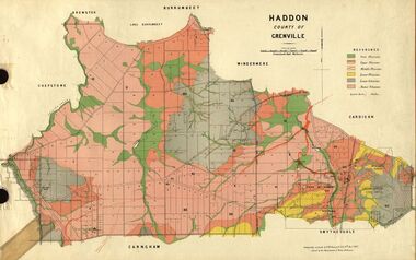 Federation University Historical Collection
Plan, Haddon, County of Grenville, 1887, 1889
... ...windermere...Ferdinand Krause taught at the Ballarat School of Mines haddon grenville krause ferdinand krause cgt lake burrumbeet windermere chepstowe bailies creek snake valley lead nentingbool preemptice right cardigan state forest haddon state forest Geological Map of Haddon in the County of Grenville surveyed by Ferdinand Krause. ...Ferdinand Krause taught at the Ballarat School of MinesGeological Map of Haddon in the County of Grenville surveyed by Ferdinand Krause. haddon, grenville, krause, ferdinand krause, cgt, lake burrumbeet, windermere, chepstowe, bailies creek, snake valley lead, nentingbool preemptice right, cardigan state forest, haddon state forest -
 Ballarat Tramway Museum
Film - Movie Film & Box, Kodak, 1960
... West Line” 24:35 21 outbound in Sturt St near Raglan St, approaches and passes the Camera. 25:09 12, showing City Oval, approaches and passes the camera, outbound near Windermere St. 25:33 13 showing View Point, goes away from the camera – location? ...West Line” 24:35 21 outbound in Sturt St near Raglan St, approaches and passes the Camera. 25:09 12, showing City Oval, approaches and passes the camera, outbound near Windermere St. 25:33 13 showing View Point, goes away from the camera – location? ...Yields information in movie film format of Ballarat trams in 1960, how the system operated and was used by people., Yields information in movie film format of Ballarat trams in 1960, how the system operated and was used by people.Movie film - 8mm, approx. 30mins, with leader strip on a plastic reel, within a black and white plastic box, titled "Ballarat No. 1. 1960". Has been transferred to DVD - see Reg item 4100 as Segment No. 2. Made by Ben Parle. Also transferred to DVD by Rod Cook Oct. 2015, via Roger Greenwood for use in his DVD, "The City of Ballarat Trams, Gardens & Gold" of 2016. See Reg Item 6883. Synopsis: based on time. 0:00 View of typed introduction, noting that this is a pictorial record of Ballarat. 0:10 Title “The Tramways of Ballarat 1960, Part 1” 0:16 13, showing “View Point” at Stones Corner, Bridge St, east end, with trolley pole being turned, while another single trucker heads out towards Mt Pleasant. 0:25 13 leaving Stones Corner, short approach and then longer trailing shot of the tram going towards the City in Bridge St. 0:44 View out of front of tram in Bridge St heading towards the City, with cars in the photo, then passing through city Loop, no trams in the loop and running up to Lydiard St Nth and crossing the road. 1:22 Running up Sturt St from Armstrong St, passes over Dawson St X-over and up to the next intersection, Lyons St. 1:54 Title “The View Point Line” 1:59 19 inbound, in Ripon St, from crossing Mair St, towards camera and then passing away and turning into Sturt St. 2:49 View of a “Warning Oncoming Trams” sign 2:52 19 in Ripon St, going to View Point, crossing Webster St towards camera, then going away through the disconnected Victoria Ave loop, pass the “Warning Oncoming Trams” sign. Note very windy scene with people running across roads. 3:17 19 in Wendouree Parade, in bound, though showing destination View Point, going away from the camera, past the View Point Hotel. 3:39 19 coming towards camera near Excerpt or Devon St and then going away towards the terminus. 4:04 19 at the terminus, stationary, with a single trucker 3?, passing from Macarthur St into Wendouree Parade, behind 19. 4:20 33 coming towards camera in Wendouree Parade from St Aidans Drive, stopping to pick up passenger at Forest St and then going away towards the City, photographed from near the depot, on a wet and windy day. 4:54 35 in Wendouree Parade, coming towards the Camera from St Aidans Drive and then going away with the Gardens Loop area in the background. Tram stops at stop to let a passenger off. 5:28 21 leaving Gardens Loop for the City via the Depot, green light in signal can be seen. 5:43 28?, closely followed by 26 turn from Drummond St South into Sturt St. 6:18 Scene opens with shot of “Sebastopol” destination on a bogie tram. 6:21 Title “The Sebastopol Line” 6:24 21 turning from Sturt St into Drummond St Sth with destination of Bell St and then going away from the camera. 6:55 38 in Drummond St Sth, coming towards the camera and then passing the camera with Sturt St just in the view. 7:10 21, showing Gregory St, in Drummond St Sth, approaching and then going away, entering the Urquhart St Loop, 7:39 34 in Drummond St Sth (location check required (Latrobe?)), approaches camera, picks up passengers and the goes away. 8:09 39 at ? Street, turns from Drummond St Sth into Skipton St, after picking up and setting down passengers, bound for Sebastopol 8:55 35 inbound in Skipton St passes through the Bell Street Loop, and then goes away from the camera. 9:33 42 outbound in Skipton St, approaches the camera, passes and then crosses over the half the road into Albert St. 10:00 39 inbound in Albert St – location? 10:31 34 outbound for Sebastopol, approaches camera and just starts to pass by. 10:36 34 in Grey St crossing loop, crosses 42 inbound. 10:59 39 outbound in Albert St, with shopping centre in bound, approaches camera, passes and then crosses over Albert St. Mid morning scene. 11:39 39 inbound, Albert St south, approaches camera and then passes and the crosses over Albert St. 12:16 41 outbound in Albert St passes the camera, and pulls into the terminus with the conductor getting out on the back bumper to pull the pole down as the tram stops and a passenger walks into the Royal Hotel. 12:39 Title “The Lydiard Street North Line” 12:44 Filmed from the Hotel balcony, 21 inbound in Lydiard St Nth passes over Mair St, stops while 33 passes in the other direction. 13:18 With the red light showing on the Seymour St loop signal, 33 inbound for Sebastopol stops and picks up many passengers, passes the camera and runs past the VRI building in the background and through the loop. Possibly filmed on a Sunday given the ladies dresses and quieter streets. 14:01 30 outbound, passes the camera and stops at Macarthur St. Filmed alongside the brick wall of the cutting. 14:28 30 inbound arrives, passes through the Gregory St loop and then proceeds past the camera, making a stop to pick up passengers. 15:14 28 in Lydiard St Nth – location?, approaches and goes away from the camera, north of Gregory St. 15:34 28 ditto location? 15:53 21 arrives at the terminus with passengers getting on and off. 16:11 View of the a vertical positioned “End of Section” sign on a pole at the terminus and then lifting the camera to see the timetable board and the stop sign. 16:33 31 in Bridge St passing Morseheads and then turning into Sturt St, stops at the Grenville St stop, while another single trucker comes down to the stop from the City. 16:58 31 outbound in Bridge St, with destination of Victoria St. 17:14 Title “The Victoria Street Line” 17:18 31 outbound to Victoria St from Stones Corner. Starts with an overhead shot, shows clock at the Caltex service station,. 17:37 31 inbound approaching Bakery Hill and then descending to the junction after it passes camera. 18:09 25 climbing outbound in Victoria St, passing the camera, to then pass through the King St loop. 18:47 25 inbound in Victoria St, passing the camera, then pass through the King St loop, with St Alypius Church in the background. 19:36 14 approaching the rail bridge in Victoria St and stopping at the 2nd last stop to left of passengers. 20:01 14 leaving the terminus and approaching the camera and the a short sequence going away, to the next stop to pick up quite a few passengers. 20:14 “Trams Stop Here” sign, metal wrap around on a steel pole. 20:16 Title “The Mount Pleasant Line” 20:21 11 inbound in Main St, with a passenger leaping off the tramcar and another getting off just before the junction. 20:45 11 passes the junction and then proceeds away from the camera in Bridge St. 21:04 30 outbound in Main St, then turns into Barkly St, a bus (Eclipse Motors) passes in Main St just before the sequence ends. 21:31 30 inbound near Steinfield St. (exact location?) 21:49 25 approaches the camera, then proceeds away and passes through the Grant St. loop. 22:29 25 inbound, windy day, between Grant and Cobden, (exact location?), with a horse drawn bread van in the view and the breadman walking behind the tram as it passes. 23:02 11 outbound in Barkly St, (exact location?) 23:37 11 inbound in Barkly St (exact location?) 23:44 Mt Pleasant terminus signage 23:50 30 approaches the terminus and then stops with the conductor alighting turning the pole, passengers getting on and off and the driver appearing at the other end. 24:32 Title “The Gardens Via Sturt St. West Line” 24:35 21 outbound in Sturt St near Raglan St, approaches and passes the Camera. 25:09 12, showing City Oval, approaches and passes the camera, outbound near Windermere St. 25:33 13 showing View Point, goes away from the camera – location? 25:44 12 comes from St. West, inbound passes the camera and then stop as the next stop next Talbot St? 26:21 Short sequence of a “Warning Oncoming Trams” sign 26:28 42 inbound in Sturt St West, just before Ripon St, view coming towards camera and then going away to cross Ripon St. 27:10 34 passes through the Parker St loop 27:25 35 or 39 inbound past the college in Sturt St West 28:04 41 outbound at the Russell St curve, passes away from the camera. 28:11 35? inbound passes away from the camera through the Victoria Park or Morrison St loop, swinging out into the roadway. 28:29 View of timetable sign at Hamilton Ave. 28:37 35 turning from Sturt St West into Hamilton Ave, can see the conductor changing over the barrier rails. 29:11 42 inbound, crosses another bogie tram (35?) at Carlton St loop then passes the camera and goes past the Olympic rings monument. 29:42 12 approaches the Carlton St gates. 30:07 12 outbound, crosses a bogie tram in the loop with both trams then leaving the loop. 30:20 Title “End of Part One” Written labels giving title information on outside of box.trams, tramways, ballarat, sebastopol, lydiard st north, victoria st, mt pleasant, sturt st west -
 Bendigo Historical Society Inc.
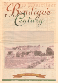
Newspaper - LONG GULLY HISTORY GROUP COLLECTION: BENDIGO'S CENTURY VOLUME SEVEN: 1960 - 1969
... Dispensary Gillies Famous Pies William Basil Ashman Golden Gate Hotel Grieves Family Bendigo Town Hall Mr R R Anderson Mr E H Brown Cr Neville Oliver Cr Tom Flood Traffic Commission Lansell FAmily ABEV-1 Bendigo Ordnance Factory ACTU Bendigo Trades Hall Council The Ramsay Report Bendigo Benevolent Home Bendigo Home and Hospital for the Aged Princess Theatre Amoco Lake Eppalock Bendigo Training Prison Bendigo Police Station Lock-up Shamrock Hotel Rifle Brigade Hotel Hopetoun Hotel ANZ Bank Marong Shire Offices Sir Rohan Delacombe St Paul's Church Que O'Hoy Waldron Family Windermere Hotel Aids & Appliance Shop Anne Caudle Centre E C Thompson Mayfair Hams Sandhurst Guest House Lyric Theatre Chinese Joss House Ordnance Factory Sir John Jenson Bridge Street Chinese Quarter Bendigo City Hall Cr R F Turner Cr Tom Flood Victorian Inland Meat Authority New Zealand Insurance Co Mrtropolitan Security Service Bendigo Easter Fair Society Golden Square High School Eaglehawk High School Bendigo Technical College Mr Ralph W Birrell Bendigo Fountain Plaza The Bethlehem Home for the Aged Dick Hazeldene Victorian Egg Board Bendigo United Cricket Club South Bendigo United Cricket Club Western Mining Corporation Les Priest Alexandra Fountain Bendigo Advertiser Cr W Cambridge Bendigo Council Eaglehawk Council Strathfieldsaye Shire Huntly Shire Marong Shire David Thomas Senator John Gorton Bendigo's College of Advanced Education Bank of New South Wales Harp and Shamrock Hotel The Honorable Leslie William Galvin Kurmala Cain Government Hanro Knitting Mills Myer Store Sidney Myer Davey Brothers Grocery Store National Trust Myer Emporium Myer's Ltd Cox Bros (Australia) Ltd Dame Merlyn Myer Baillieu Myer Frank Greenaway Institute of Technology Gas & Fuel Corporation Bendigo Railway Station ANZ Bank City Family Hotel TAB Branch Senior Constable Alfred Herbert Wright Senior Constable Allan Raymond Brown Victorian Football League Bendigo Police Barracks Camp Hill State School State Electricity Commission The Country Party The Labor Party Transport Regulation Board Stuart Anderson Grose FAmily Jean Theodore De Ravin Kyneton Shire Sir William McDonald Mines Department The Loddon Hospitals Region group Laundry and Central Linen Service Kevin Wynne Albert Vivian Gray Bradford Cotton Mills Ltd Bradmill Industries Ltd Victoria Hill Bendigo and District Tourist Association Professor Brian Lewis Melbourne University Victorian Chinese Community Loong Sun Loong Stafford Ellinson Coles' Store North Deborah Mining Company NL Noel Beaton MHR Durham Ox Hotel Taylor Family Supplement to the Bendigo Advertiser, December 15, 1999 Volume Seven: 1960-1969 titled Bendigo's Century. ...Supplement to the Bendigo Advertiser, December 15, 1999 Volume Seven: 1960-1969 titled Bendigo's Century. The front has a photo of the BCV 8 Studio. Contains photos and local news, council matters, planning, Who's Who, Weather, Sport and Business and some Advertisements. Photos include Early stages in the construction of the Eppalock tower and bridge pillars, Christine Wiseman, TV8's first news reader Ron Alderton, Dr Albert L Beischer, Advertiser buiding, fire at the Advertiser building, Oscar Flight, Bendigo Town Hall, William Basil Ashman, Lake Eppalock, Premier Henry Bolte, Que O'Hoy, Sandhurst Guest House, The Lyric Theatre, E C Thompson, The elm tree in Market Square, Leslie Galvin, The original Myer Store, The Joss House, Sidney Myer, Bendigo Police Barracks, Bunratty Castle, Albert Vivian Gray, The Victoria Hill site, Architects drawing of the new council administrative offices and Noel Beaton MHR.bendigo, history, long gully history group, the long gully history group - bendigo's century volume seven: 1960 - 1969, bendigo advertiser, bcv 8, eppalock dam, premier henry bolte, the criterion hotel, mccarthy family, teachers training college, bendigo original teachers college, long gully state school, stramit, bendigo university site committee, mrs christine wiseman, bendigo city council, the broadcasting control board, general television pty ltd, bendigo central victoria telecasters pty ltd, mr davidson, bennett's arcade, woolworth's, white hills swimming pool, herb elliott, sailor's guide, toni riley pharmacies, rising sun hotel, ron alderton, dr albert l beischer, channel 8, melbourne herald, 3bo, bendigo advertiser officeslyceum theatre, junior technical school white hills, mount alvernia hospital, most reverend dr b d stewart, sisters of the franciscan missionaries of the divine motherhood, lazarus family, bendigo's tramways, state electricity commission, george pethard, lance pethard, bendigo advertiser fire 29/7/1962, riverine herald, the herald and weekly times, bendigo art gallery, oscar flight, hollands foundry, eaglehawk u.f.s. dispensary, gillies famous pies, william basil ashman, golden gate hotel, grieves family, bendigo town hall, mr r r anderson, mr e h brown, cr neville oliver, cr tom flood, traffic commission, lansell family, abev-1, bendigo ordnance factory, actu, bendigo trades hall council, the ramsay report, bendigo benevolent home, bendigo home and hospital for the aged, princess theatre, amoco, lake eppalock, bendigo training prison, bendigo police station lock-up, shamrock hotel, rifle brigade hotel, hopetoun hotel, anz bank, marong shire offices, sir rohan delacombe, st paul's church, que o'hoy, waldron family, windermere hotel, aids & appliance shop, anne caudle centre, e c thompson, mayfair hams, sandhurst guest house, lyric theatre, chinese joss house, ordnance factory, sir john jenson, bridge street chinese quarter, bendigo city hall, cr r f turner, cr tom flood, victorian inland meat authority, new zealand insurance co, mrtropolitan security service, bendigo easter fair society, golden square high school, eaglehawk high school, bendigo technical college, mr ralph w birrell, bendigo fountain plaza, the bethlehem home for the aged, dick hazeldene, victorian egg board, bendigo united cricket club, south bendigo united cricket club, western mining corporation, les priest, alexandra fountain, bendigo advertiser, cr w cambridge, bendigo council, eaglehawk council, strathfieldsaye shire, huntly shire, marong shire, david thomas, senator john gorton, bendigo's college of advanced education, bank of new south wales, harp and shamrock hotel, the honorable leslie william galvin, kurmala, cain government, hanro knitting mills, myer store, sidney myer, davey brothers grocery store, national trust, myer emporium, myer's ltd, cox bros (australia) ltd, dame merlyn myer, baillieu myer, frank greenaway, institute of technology, gas & fuel corporation, bendigo railway station, anz bank, city family hotel, tab branch, senior constable alfred herbert wright, senior constable allan raymond brown, victorian football league, bendigo police barracks, camp hill state school, state electricity commission, the country party, the labor party, transport regulation board, stuart anderson, grose family, jean theodore de ravin, kyneton shire, sir william mcdonald, mines department, the loddon hospitals region group laundry and central linen service, kevin wynne, albert vivian gray, bradford cotton mills ltd, bradmill industries ltd, victoria hill, bendigo and district tourist association, professor brian lewis, melbourne university, victorian chinese community, loong, sun loong, stafford ellinson, coles' store, north deborah mining company nl, noel beaton mhr, durham ox hotel, taylor family -
 Bendigo Historical Society Inc.
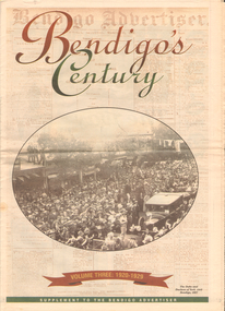
Newspaper - LONG GULLY HISTORY GROUP COLLECTION: BENDIGO'S CENTURY VOLUME THREE: 1920 - 1929
... History House 11 Mackenzie Street Bendigo goldfields BENDIGO History long gully history group The Long Gully History Group - Bendigo's Century - Volume Three: 1920 - 1929 Bendigo Advertiser Duke and Duchess of York Cr E M Vains R Putnam A J Taylor J H Jackson W Crowley Sandhurst Football Club George Lansell St Peter's Church Bendigo Junior Technical School Prince of Wales Unity Mine Mr W Wilson Badak Tin Mining Syndicate Mr T W OrtonMr H Scarborough Mr Raleigh General Sir W R Birdwood The Soldiers' Memorial Committee Bendigo City Council RSL Memorial Hall Captain G C Wilson Lietenant R J Parer Lieutenant J C McIntosh Cr J P Carolin H K Morris E A Morris Turf Tavern Hotel Rev Donald Baker All Saints' Pro--Cathedral Keck's Nursery Bendigo Amalgamated Goldfields Rising Sun Hotel Leanne McDonnell Most Rev John McCarthy Sir John Quick Prime Minister Billy Hughes State Rivers and Water Supply Commission Diptheria Edna Stevens Bendigo Railway Workshops Watson Sustenance Fund Sir Joseph Cook Dr Lanza Bendigo Amalgamated Goldfields Bendigo Benevolent Asylum Miner's Phthisis Bendigo Gas Company Electric Light Company Bendigo Sewerage Authority Commonwealth bank Cr Curnow the Earl of Stradbroke Dame Nellie Melba Princess Theatre Lt-Col G Hurry H SW Lawson Countess of Stradbroke Clunes Woollen Mills Girton College Mrs Polglaise Mrs Kennedy Gold Discovery Memorial Cr M G Giudice Victorian Co-operative Freezing Company Bendigo Brick and Tile Company Mr Lawson Soldiers' Memorial Windermere Hotel Toni Riley Pharmacy Bendigo Gaol Mr A A Dunstan MLA New Red White and Blue Mine Claude de Vere Walter Osborne Sir John and Lady Quick Jonathan Smalley Bendigo Advertiser St Paul's Bells Mr T Cambridge Epsom Public Hall Bendigo School of Mines Major Lansell Mr H S W Lawson Cr David Andrew Colonel Hurry Mr S Bruce Bendigo Sewerage Authority Eppalock Weir Scheme Bendigo Football League R S L Memorial Major G V Lansell Lempriere MR S M Bruce Sandhurst Hotel Market Square Big Hill Tunnel Bendigo Football League Bendigo United Cricket Club South Bendigo Rex Sacred Heart Cathedral Hercules Mine Gillies Aids & Appliance Shop Anne Caudle Centre Fizelle & Mulqueen South New Moon Mine Bendigo Sewerage Authority Mr A A Kelley Epsom Sewerage Works White Hills Botanical Gardens Mr J Sternberg MLC Bendigo Book of Remembrance Bendigo Football League Senator General Drake-Brockman Captain Dyett School of Mines Handschin and Romus Hanro (Aust.) ...Newspaper supplement titled Bendigo's Century Volume Three: 1920 - 1929. Front page has a photo of The Duke and Duchess of York visit to Bendigo, 1927. Each year has heading of Who's Who, Weather, Sport and Business. First years are 1910 - 1919 titled The way we were. 1920 is titled Prince hailed. 1921 - City racks up a milestone. 1922 - Furore erupts. 1923 - Felons escape from city gaol. 1924 - Bid to finish RSL memorial. 1925 - Foul odour over sewerage plan. 1926 - Lest we forget Bendigo's fallen. 1927 - Royal Visit captures city. 1928 - Four shot in farm tragedy. 1929 - Billie's trip to remember.bendigo, history, long gully history group, the long gully history group - bendigo's century - volume three: 1920 - 1929, bendigo advertiser, duke and duchess of york, cr e m vains, r putnam, a j taylor, j h jackson, w crowley, sandhurst football club, george lansell, st peter's church, bendigo junior technical school, prince of wales, unity mine, mr w wilson, badak tin mining syndicate, mr t w ortonmr h scarborough, mr raleigh, general sir w r birdwood, the soldiers' memorial committee, bendigo city council, rsl memorial hall, captain g c wilson, lietenant r j parer, lieutenant j c mcintosh, cr j p carolin, h k morris, e a morris, turf tavern hotel, rev donald baker, all saints' pro--cathedral, keck's nursery, bendigo amalgamated goldfields, rising sun hotel, leanne mcdonnell, most rev john mccarthy, sir john quick, prime minister billy hughes, state rivers and water supply commission, diptheria, edna stevens, bendigo railway workshops, watson sustenance fund, sir joseph cook, dr lanza, bendigo amalgamated goldfields, bendigo benevolent asylum, miner's phthisis, bendigo gas company, electric light company, bendigo sewerage authority, commonwealth bank, cr curnow, the earl of stradbroke, dame nellie melba, princess theatre, lt-col g hurry, h sw lawson, countess of stradbroke, clunes woollen mills, girton college, mrs polglaise, mrs kennedy, gold discovery memorial, cr m g giudice, victorian co-operative freezing company, bendigo brick and tile company, mr lawson, soldiers' memorial, windermere hotel, toni riley pharmacy, bendigo gaol, mr a a dunstan mla, new red white and blue mine, claude de vere, walter osborne, sir john and lady quick, jonathan smalley, bendigo advertiser, st paul's bells, mr t cambridge, epsom public hall, bendigo school of mines, major lansell, mr h s w lawson, cr david andrew, colonel hurry, mr s bruce, bendigo sewerage authority, eppalock weir scheme, bendigo football league, r s l memorial, major g v lansell, lempriere, mr s m bruce, sandhurst hotel, market square, big hill tunnel, bendigo football league, bendigo united cricket club, south bendigo rex, sacred heart cathedral, hercules mine, gillies, aids & appliance shop, anne caudle centre, fizelle & mulqueen, south new moon mine, bendigo sewerage authority, mr a a kelley, epsom sewerage works, white hills botanical gardens, mr j sternberg mlc, bendigo book of remembrance, bendigo football league, senator general drake-brockman, captain dyett, school of mines, handschin and romus, hanro (aust.) bendigo knitting mills, charles handschin, farmers' union, andrew sunstan mla, country progressive party, john allan, captain g j c dyett, eahlehawk ufs dispensary, data fundamentals, the duke and duchess of york, the hercules mine, cr j a michelsen, lansell family, bendigo agricultural society, huntly shire council, bendigo creek trust, south african war memorial, cr j h curnow, st paul's church of england diamond jubilee, bendigo chamber of commerce, bendigo freezing works, bendigo pottery, bendigo trotting club, new red white and blue mine, the conservatory, cr e g batchelder, hercules mine, billie rigby, bendigo railway station, travellers' aid society, eppalock weir, the state rivers and water supply commission, bendigo railway workshops, frank grove, cr curnow, electric supply company, state electricity commission, australian aero club, bendigo preserving company, jardine, busbridge, feeman, mr h pearce, bfl, fred wood -
 Bendigo Historical Society Inc.
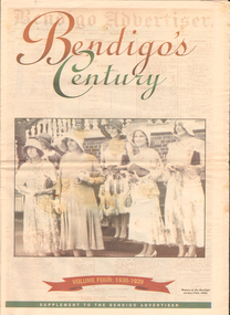
Newspaper - LONG GULLY HISTORY GROUP COLLECTION: BENDIGO'S CENTURY VOLUME FOUR: 1930 - 1939
... History House 11 Mackenzie Street Bendigo goldfields BENDIGO History long gully history group The Long Gully History Group - Bendigo's Century - Volume Four: 1930 - 1939 Eaglehawk Cricket Club Ernst Mueller The Bendigo Stock ExchangeL L Dungey T Williams M P Kelly C Mueller E Hommoloff R Kelly T H Busst T Hall R Tremabath E A Woodcock C Burridge Charshalton Mine Edith and G V Lansell Laboratory St Andrew's Church RSL Memorial Hall Mr Gordon Carter Sir John Monash State Electricity Commission Cr R Watson Colonel GT V Lansell Empire Press Congress Bendigo Advertiser Mr E J Hogan Eppalock Weir Lyric Theatre Bendigo Red Cross Mrs George Mackay St Andrew's Presbyterian Church Mrs William Hunter Right Rev John Douse Langley Monsignor Rooney Bendigo Art Gallery The Ironbark Mine Coliban Water Mr W Wright Station 3BO Amalgamated Wireless of Australia Ltd Advance Bendigo Group The North League St Aidan's Orphanage Bendigo Freezing Works Mr W Wright Bendigo Advertiser Mr W J Stephens Advance Bendigo Group North League Garden Gully United Gold Mining Company Bendigo Football League Sir John Quick John Quick Snr Ironbark Foundry Bendigo Evening News Bendigo Independent Bendigo Advertiser Deakin Governmnet Sir Charles Kingsford Smith Southern Cross Eppalock Weir Bendigo Art Gallery The Hercules Mine Gillies Aids & Appliance Shop Anne Caudle Centre Bill Woodfull Harold Larwood Dr John McCarthy The Hercules Douglas Jardine Don Bradman Sacred Heart Cathedral Joseph Stapleton John Lynch Bert McConchie New Red White and Blue Mine Royal Humane Society William James Vernon Shaw South New Moon Mine Bendigo Hospital Bendigo Base Hospital Duke of Gloucester RSL Memorial Hall Electricity Commission Eaglehawk Borough Council The Plaza Backhaus Estate Amalgamated Freezing Company Fortuna Villa Mrs Edith Lansell Colonel Lansell The Hercules Mine Toni Riley Pharmacy Boardwalk Barkly Hyett The Big Blue Consolidated Company The Bendigo Hospital Eaglehawk Football Team Kurmala Wing of the Bendigo Base Hospital Sir Isaac Isaacs Lyric Theatre Sir John Quick Hanro Knitting Mills St Luke's Toddlers Home St Aidan's Orphanage RSL Memorial Hall Lord and Lady Huntingfield Cr Michelsen Bendigo Art Gallery Bendigo Agricultural Show New Blue Mine Joseph Stapleton Bendigo Law Association Bendigo Hospital Committee of Management Bendigo Rotary Club Mr J McRae Education Department Andrew Sunstan Sir Stanley Argyle Bendigo Football League North Blue Mining Company Cr Staples King George V King Edward VIII Cr J A Michelsen Andrew McLay Bendigo Advertiser Cohn Bros Mrs Wallis Simpson King George VI Capping Mine Shafts 1936 Bendigo Art Gallery Madge Freemen William John Leslie Cross Judge Wasley The Myer Emporium The Baptist Church Salvation Army Ron Masters The Central Nell Gwyn Sir John Quick Leanne McDonnell Windermere Hotel Rev Donald Baker John Rumbold Central Nell Gwynne The Beehive Building The Beehive Store James Buick and Co Thomas Hope Henderson Buick Henderson & Co Mr Goodison Mr R O Henderson Lt-Col Henderson Angus Mackay Bendigo Sewerage Authority Mr S Gordon Moore Commercial Bank of Sydney Bendigo Advertiser Edward Alan Morcom Polio DR Gardner Kerr The Right Rev Conald Baker Ridley Theological College Newspaper supplement titled Bendigo's Century Volume Four: 1930 - 1939. ...Newspaper supplement titled Bendigo's Century Volume Four: 1930 - 1939. Front page is titled Bendigo's Century and has a photo of some women at the Bendigo Jockey Club, 1930s. Each year has heading of Who's Who, Weather, Sport and Business. First years are 1930 - 1939 titled A look back when. The page has photos of the Eaglehawk Cricket Club's first A Grade cricket premier ship team (1932 - 1933)., The monument to the late Bendigo mining magnate Ernst Mueller in Rosalind Park, The Bendigo Stock Exchange in the early 1930's - pictured are L L Dungey, T Williams, M P Kelly, C Mueller, E Hommoloff, R Kelly, T H Busst, T Hall, R Trembath, E A Woolcock, and C Burridge, the Carshalton mine in 1936 and The Edith and G V Lansell Laboratory at the Bendigo Hospital. 1930 - a photo of St Andrew's Church, the sundial outside the RSL Memorial Hall, The late Monsignor Rooney and The late John Douse Langley. The Ironbark Mine was the top gold producer. 1931 - Radio station goes on air, 1932 - Sir John dies, 1933 Bodyline men come to town, 1934 - Heroic rescues, 1935 - Hospital's new wing opened, 1936 - King mourned, 1937 - Beehive store towers above, 1938 - Mining shows mixed results and 1939 - Outbreak of war sobering.bendigo, history, long gully history group, the long gully history group - bendigo's century - volume four: 1930 - 1939, eaglehawk cricket club, ernst mueller, the bendigo stock exchangel l dungey, t williams, m p kelly, c mueller e hommoloff, r kelly, t h busst, t hall, r tremabath, e a woodcock, c burridge, charshalton mine, edith and g v lansell laboratory, st andrew's church, rsl memorial hall, mr gordon carter, sir john monash, state electricity commission, cr r watson, colonel gt v lansell, empire press congress, bendigo advertiser, mr e j hogan, eppalock weir, lyric theatre, bendigo red cross, mrs george mackay, st andrew's presbyterian church, mrs william hunter, right rev john douse langley, monsignor rooney, bendigo art gallery, the ironbark mine, coliban water, mr w wright, station 3bo, amalgamated wireless of australia ltd, advance bendigo group, the north league, st aidan's orphanage, bendigo freezing works, mr w wright, bendigo advertiser, mr w j stephens, advance bendigo group, north league, garden gully united gold mining company, bendigo football league, sir john quick, john quick snr, ironbark foundry, bendigo evening news, bendigo independent, bendigo advertiser, deakin governmnet, sir charles kingsford smith, southern cross, eppalock weir, bendigo art gallery, the hercules mine, gillies, aids & appliance shop, anne caudle centre, bill woodfull, harold larwood, dr john mccarthy, the hercules, douglas jardine, don bradman, sacred heart cathedral, joseph stapleton, john lynch, bert mcconchie, new red white and blue mine, royal humane society, william james, vernon shaw, south new moon mine, bendigo hospital, bendigo base hospital, duke of gloucester, rsl memorial hall, electricity commission, eaglehawk borough council, the plaza, backhaus estate, amalgamated freezing company, fortuna villa, mrs edith lansell, colonel lansell, the hercules mine, toni riley pharmacy, boardwalk, barkly hyett, the big blue consolidated company, the bendigo hospital, eaglehawk football team, kurmala wing of the bendigo base hospital, sir isaac isaacs, lyric theatre, sir john quick, hanro knitting mills, st luke's toddlers home, st aidan's orphanage, rsl memorial hall, lord and lady huntingfield, cr michelsen, bendigo art gallery, bendigo agricultural show, new blue mine, joseph stapleton, bendigo law association, bendigo hospital committee of management, bendigo rotary club, mr j mcrae, education department, andrew sunstan, sir stanley argyle, bendigo football league, north blue mining company, cr staples, king george v, king edward viii, cr j a michelsen, andrew mclay, bendigo advertiser, cohn bros, mrs wallis simpson, king george vi, capping mine shafts 1936, bendigo art gallery, madge freemen, william john leslie cross, judge wasley, the myer emporium, the baptist church, salvation army, ron masters, the central nell gwyn, sir john quick, leanne mcdonnell, windermere hotel, rev donald baker, john rumbold, central nell gwynne, the beehive building, the beehive store, james buick and co, thomas hope henderson, buick henderson & co, mr goodison, mr r o henderson, lt-col henderson, angus mackay, bendigo sewerage authority, mr s gordon moore, commercial bank of sydney, bendigo advertiser, edward alan morcom, polio, dr gardner kerr, the right rev conald baker, ridley theological college -
 Bendigo Historical Society Inc.
Newspaper - LONG GULLY HISTORY GROUP COLLECTION: BENDIGO'S CENTURY VOLUME FIVE: 1940 - 1949
... History House 11 Mackenzie Street Bendigo goldfields BENDIGO History long gully history group The Long Gully History Group - Bendigo's Century - Volume Five: 1940 - 1949 Bendigo Advertiser Central Deborah Mine Jackie Lewis Bob Johnson W Landy Ryga Yates Les Johnson Central Nell Gwynne Department of Defence Bendigo Jockey Club 8th Division Robert Menzies Deborah Mine Bendigo Decentralisation Vigilance Committee Cr W H Taylor Bendigo War Funds Organisation The Easter Fair Society Bendigo Agricultural Show Committee Mr E G Ham Mr J V Fairbairn Cr A Staples The Bendigo Chamber of Commerce Richard Hartley Smith Abbott Captain Harley Abbott Bendigo Art Gallery Bill Woodfull Bendigo High School North Deborah Mine Boardwalk Toni Riley Pharmacy Windermere Hotel Cr G A Pethard Coliban System North Deborah Mine Bendigo Pottery Bendigo Trades Hall Council Private Lawrence Burstall Major-General G J Rankin MHR Andrew Dunstan Ordnance Factory Royal Australian Navy HMAS Bendigo SEC Offices MUIOOF YMCA Georger Addlem Fred Addlem Cr A J Anderson Pauline Buvhan Thompson Leslie Thompson Edward Joseph Leonski Bendigo Football League Mr J Dedman William Stephens Forest Street Methodist Church Pte Charles Phillips Pte W E durward Pte T Foley William John Stephens Central Nell Gwynne Air Chief Marshall Sir Arthur Tedder Cr Taylor United Nations Flying Officer R Bruce Tuff Flight Lieutenant Owens Royal Air Force Commonwealth War Workers Housing Trust Scheme Mr S McKinnon Bendigo Decentralised Vigilance Committee Ravenswood Estate John Lienhop MLC Margaret (Peggy) Brennan Strathfieldsaye Shire Council School of Mines Bendigo Base Hospital William George Ashman Ashman's Tailors Bendigo Jockey Club Victorian Football Association Bendigo East Swimming Pool Deborah Anticline Specimen Hill Methodist Church North Deborah Adolf Hitler Benito Mussolini Australian 7th Division Cr Galvin Bendigo War Funds Organisation HMAS Bendigo Lt-Commander Jackson Bendigo Football League Central Deborah Mine Victoria Day Cr Truscott Bendigo Gaol Lansellstowe AWAS Barracks Bendigo Citizens Committee John Cain Snr Ordnance Factory Bendigo Agricultural Society The Duke of Gloucester Duchess of Gloucester Bendigo Tennis Association North Deborah Gillies Famous Pies Aids & Appliance Shop Mrs Georgina Scott Dr J A Neptune Scott Alfred Sisley Corot Daubigney Louis Sonnenberg Gas Employees' Union John Lienhop Soldier Settlement Commission Burnewang Estate King George VI Princess Elizabeth Lt Philip Mountbatten Mr E J W Herbert Ansett Airways Reg Ansett Most Rev Dr John McCarthy Dr Bernard Stewart Michael Giudice Bendigo United Breweries Bendigo Lyric Photo Plays Bendigo Sun Newspaper Shamrock Hotel West Bendigo Progress Association Alan McDonald South Bendigo Football Club Albert Collier J T Webbo Mervyn Tresize State Rivers and Water Supply Commission Eppalock Reservoir Public Works Committee Bendigo Rotary Club John Edgar Bendigo Base Hospital Albert Dunstan Benevolent Home Magetti's Wine Hall Wallace Reef Wine Hall Magetti Family Albert Magetti Lance Galvin Bradford Cotton Spinnings (Victoria) Pty Otd Arthur Syer Stanley Crossman Albert Arthur Dunstan Rev Dr Henry Backhaus City Family Hotel Lyric Theatre Bank of Australasia City Club HotelColonial Mutual Building R Matchett & Co Lansellstowe Leonard Lansell Bendigo Bas Hospital Australian Women's Army Service Mr Hollway Kenworth (Aust) Ltd Foggitt Jones's Bacon Factory Gordon Sayers Sandhurst Trustees Dr John Drowley Alexander Hislop Royal Mint North Deborah Mine Ironbark South Mining Company Central Nell Gwynne Company New Chum Syncline Newspaper supplement titled Bendigo's Century Volume Five: 1940 - 1949. ...Newspaper supplement titled Bendigo's Century Volume Five: 1940 - 1949. Each year has heading of Who's Who, Weather, Sport and Business. Front page is titled Bendigo's Century and has a photo of a group of soldiers in uniform and with rifles. They were district servicemen on leave in 1944. Each year has heading of Who's Who, Weather, Sport and Business. First years are 1940 - 1949 titled Bendigo as it was. It has two photos of women wading through the 1949 Pall Mall flood waters and one of Miners in the crib room of the Central Deborah Mine. They are Jackie Lewis, Bob Johnson, W Landy, Ryga Yates and Les Johnson. 1940 - Army moves in to racecourse, 1941 - Devastating fire at pottery, 1942 - Forces expand, 1943 - Nation's eyes on Bendigo, 1944 - News dawns of D-day landing, 1945 - City cheers the end of the war, 1946 - Celebrations begin in city, 1947 - Gallery gets top paintings, 1948 - Water plan looks good and 1949 - Flood takes a toll on city.bendigo, history, long gully history group, the long gully history group - bendigo's century - volume five: 1940 - 1949, bendigo advertiser, central deborah mine, jackie lewis, bob johnson, w landy, ryga yates, les johnson, central nell gwynne, department of defence, bendigo jockey club, 8th division, robert menzies, deborah mine, bendigo decentralisation vigilance committee, cr w h taylor, bendigo war funds organisation, the easter fair society, bendigo agricultural show committee, mr e g ham, mr j v fairbairn, cr a staples, the bendigo chamber of commerce, richard hartley smith abbott, captain harley abbott, bendigo art gallery, bill woodfull, bendigo high school, north deborah mine, boardwalk, toni riley pharmacy, windermere hotel, cr g a pethard, coliban system, north deborah mine, bendigo pottery, bendigo trades hall council, private lawrence burstall, major-general g j rankin mhr, andrew dunstan, ordnance factory, royal australian navy, hmas bendigo, sec offices, muioof, ymca, georger addlem, fred addlem, cr a j anderson, pauline buvhan thompson, leslie thompson, edward joseph leonski, bendigo football league, mr j dedman, william stephens, forest street methodist church, pte charles phillips, pte w e durward, pte t foley, william john stephens, central nell gwynne, air chief marshall sir arthur tedder, cr taylor, united nations, flying officer, r bruce tuff, flight lieutenant owens, royal air force, commonwealth war workers housing trust scheme, mr s mckinnon, bendigo decentralised vigilance committee, ravenswood estate, john lienhop mlc, margaret (peggy) brennan, strathfieldsaye shire council, school of mines, bendigo base hospital, william george ashman, ashman's tailors, bendigo jockey club, victorian football association, bendigo east swimming pool, deborah anticline, specimen hill methodist church, north deborah, adolf hitler, benito mussolini, australian 7th division, cr galvin, bendigo war funds organisation, hmas bendigo, lt-commander jackson, bendigo football league, central deborah mine, victoria day, cr truscott, bendigo gaol, lansellstowe, awas barracks, bendigo citizens committee, john cain snr, ordnance factory, bendigo agricultural society, the duke of gloucester, duchess of gloucester, bendigo tennis association, north deborah, gillies famous pies, aids & appliance shop, mrs georgina scott, dr j a neptune scott, alfred sisley, corot, daubigney, louis sonnenberg, gas employees' union, john lienhop, soldier settlement commission, burnewang estate, king george vi, princess elizabeth, lt philip mountbatten, mr e j w herbert, ansett airways, reg ansett, most rev, dr john mccarthy, dr bernard stewart, michael giudice, bendigo united breweries, bendigo lyric photo plays, bendigo sun newspaper, shamrock hotel, west bendigo progress association, alan mcdonald, south bendigo football club, albert collier, j t webbo, mervyn tresize, state rivers and water supply commission, eppalock reservoir, public works committee, bendigo rotary club, john edgar, bendigo base hospital, albert dunstan, benevolent home, magetti's wine hall, wallace reef wine hall, magetti family, albert magetti, lance galvin, bradford cotton spinnings (victoria) pty otd, arthur syer, stanley crossman, albert arthur dunstan, rev dr henry backhaus, city family hotel, lyric theatre, bank of australasia, city club hotelcolonial mutual building, r matchett & co, lansellstowe, leonard lansell, bendigo bas hospital, australian women's army service, mr hollway, kenworth (aust) ltd, foggitt jones's bacon factory, gordon sayers, sandhurst trustees, dr john drowley, alexander hislop, royal mint, north deborah mine, ironbark south mining company, central nell gwynne company, new chum syncline -
 Bendigo Historical Society Inc.
Document - R.S.L. BENDIGO COLLECTION: BENDIGO R.S.L. NEWS VOL. 1 NO. 3
... F M Carson Tooranie House Brian Abe P E Dunstan A Lam Sun Don Murray Windermere Hotel Bendigo Disposals Frank A Hill & Co Fitzpatrick's Sandhurst Dairies Pty Ltd M Williamson George Symon's Dairy W H Oakley Sir Horace Robertson British Commonwealth Occupation Forces Australian Light Horse State Savings Bank Royal Military College Golden Fleece Service Station J W Williams Tomlins Simmie Pty Ltd Clark King & Co Pty Ltd McKenna's Modern Store Bryan McKenna Wicks Knott Publication Southdown Press A Wicks Knott Publication, Printed by Southdown Press, 33 Rosslyn Street, West Melbourne. ...Bendigo R.S.L. News Volume 1, Number 3 Christmas-New Year Issue. Red, blue, yellow and gold badge on the front cover. Contains advertisements from local businesses, Bendigo R.S.L. Office Bearers 1960, news, notes from Clubs, an article titled 'When the Japs Broke Out at Cowra' and a short obituary of Sir Horace Robertson.A Wicks Knott Publication, Printed by Southdown Press, 33 Rosslyn Street, West Melbourne.magazine, organization, bendigo rsl, r.s.l. bendigo collection - bendigo r.s.l. news vol. 1 no. 3, ashmans dry cleaners, h q radio service, f c straub, hampel furniture products, pierce grenfell, ron meurer, h w snell, axedale quarries, a l & k stringer, excavations, al & b g pearce, w mcculloch & co, bendigo motor co, m g taylor, fair-view upholsterers, alwyn nelson, northern terrazzo co, l fawssett & co, bendigo sub-branch r.s.s, &, a.i.l.a., col j w swatton, h a w morey, s thompson, g j baker, j k barnes, a c harridge, j harrison, t h hume, w h pinder, d e mcgregor, f e schilling, g g styles, c vaughan, j e fay, geo j baker, a v palmer, n mclaren young, e m vains & co, g e h rowell, a v & l e smith, j r palmers, graham lowe refrigeration service, a w pulfer motors, b r burns, vic palmer, golden square dry cleaners, j w carter & sons, alltyre service pty ltd, ian wills, bill nicholls jack watts, the robyn, a g power, leo a hughes, bendigo manchester house, frank wilson, hesse bros, frank bouchier, your typewriter sales and service, tom heenan, win patten, bendigo legacy, r wilson, w e p carruthers, antonian café, kairn's auto-bits, cohns, jeffreys bread, 4th armoured regt social club, g e baldwin, bendigo & district ex-p.o.w. social club, w hargreaves, d gregor, bendigo r.s.l. ladies auxiliary, mrs h morey, mrs p floyd, mrs w hocking, mrs h sims, mrs t hall, rsl women's council of victoria, mr & mrsa kersting, w coates, a bolitho, w hocking, n mcivor, perretts, martin washington, e a bennett pty ltd, john burgoyne, 38th battalion (a.i.f.) social club, j plim c findlay, ex-navelmen's club, t staley, airforce association, a stevens, t grimes, rats of tobruk association, j ferguson, catholic war veterans' association, j noonan, t coppock, dads' association, w murphy, bendigo legacy club, win patten, t h iser, t h runnalls, legacy house, 105 anti-tank regiment social club, alwyn nelson, laurie townsing, bendigo repatriation local committee, v w hosking, w rex porter, g a pethard, f t dunphy, l m porter, e h duus, lt col thomas waitson williams dso, ric coulson, r ball & son, lorraine florist, neol searle pty ltd, bendigo and district t & p i social club, e j taylor, t wellins, w phelan, g keily, l boyd, t tuddenham, e butler, g armstrong, geo j baker, easter fair society, bendigo agricultural society, 6th battalion (a.i.f.) social club, f t dunphy, w green, r c wright, bendigo showgrounds r.a.a.o.c. camp club, j j davies, e p perrett, t g heenan, w rex porter, fred coulson, harry hall, alan bath, tom hume, ted commons, geo h baker, percy floyd, stan hunter, joe wagland, railway sub-section r.s.l., g brown, don chalmer pty ltd, bendigo timber co pty ltd, g p hyett, a w comber, w nichols, maurice f noonan, allans walk delicatessen, r b webb, jack l lyons, perrow, s paints, t c sheers, provincial motors (bendigo) pty ltd, banjo paterson, will ogilvey, ben hall, joe gardiner, major bob ramsay mc, 53rd batt., major e v timms, ww1, 2nd a.i.f., f m carson, tooranie house, brian abe, p e dunstan, a lam sun, don murray, windermere hotel, bendigo disposals, frank a hill & co, fitzpatrick's, sandhurst dairies pty ltd, m williamson, george symon's dairy, w h oakley, sir horace robertson, british commonwealth occupation forces, australian light horse, state savings bank, royal military college, golden fleece service station, j w williams, tomlins simmie pty ltd, clark king & co pty ltd, mckenna's modern store, bryan mckenna, wicks knott publication, southdown press -
 Federation University Historical Collection
Plan, Plan of Amalgamated Tenements for G.J. Carroll and Party, Ballarat West
... Carroll Webster Street Mill Street Mair Sreet Sturt Street Ballarat Railway ballaarat old cemetery Crewsick Road Gregory Street\Sussex Street Errard Street Raglan Street Lyons Stret Dawson Street Howitt Street ascot street Ripon Street Talbot Street windermere street Plan of Amalgamated Tenements for G.J. ...g.j. carroll and party, carroll, g.j. carroll, webster street, mill street, mair sreet, sturt street, ballarat railway, ballaarat old cemetery, crewsick road, gregory street\sussex street, errard street, raglan street, lyons stret, dawson street, howitt street, ascot street, ripon street, talbot street, windermere street