Showing 7 items matching "world war ii aerial photographs"
-
 B-24 Liberator Memorial Restoration Australia Inc
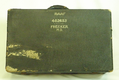
Suitcase from Mason Day Frecker, 1930s
... ...world war ii aerial photographs...World War II. The contents of M D Frecker's suitcase include World War II medals awarded to the owner, photographs, maps, pilots' handbooks, language dictionaries (Malay, Pidgin, Japanese), propaganda leaflets dropped by Japanese. Has historical and social significance, also research significance. Provenance known, owner piloted B-24 Liberator bombers and General Blamey's personal aircraft; item was donated by son. Great interpretive potential. b24 liberator bomber world war ii raaf pilot world war ii aerial ...Suitcase issued to aircraft captains or crew by RAAF during World War II. The contents of M D Frecker's suitcase include World War II medals awarded to the owner, photographs, maps, pilots' handbooks, language dictionaries (Malay, Pidgin, Japanese), propaganda leaflets dropped by Japanese.Has historical and social significance, also research significance. Provenance known, owner piloted B-24 Liberator bombers and General Blamey's personal aircraft; item was donated by son. Great interpretive potential.Worn dark suitcase belonging to Mason Day Frekker, strong cardboard covered with 'leatherette', metal fasteners on front, with carry handle. Suitcase contains Flying Log Book RAAF, Wedding Photo, National Archives Record Search Mason Day Frecker, Distinguished Flying Medal Register WW2 x 3, Papers on Medals and Victorian Ground Crew Numbers, Files 1 - 2 - 3 - Photographs, Leaflets, Pilots' Notes, Maps - Germany (28 maps), Buttons and badges and other medals."RAAF/402653/Frecker/M.D." on top surface, "M.D.F." on front surface under handle.b24 liberator bomber, world war ii, raaf pilot, world war ii aerial photographs, a22.00 -
 Port Melbourne Historical & Preservation Society
Photograph - Aerial view of Port Melbourne, 23 Dec 1945
... Port Melbourne Historical & Preservation Society Port Melbourne Town Hall 333 Bay Street Port Melbourne melbourne Piers and Wharves - Station Pier Piers and Wharves - Town Pier War - World War II Built Environment Transport - Railways Missions to Seamen Swallow & Ariell Ltd One of three prints of aerial photographs of Port Melbourne 23.12.1945, showing different areas and to different scales: this one vertical, takes in Station and Town Piers, railyards, Missions to Seamen, Engine Works, temporary US wartime structures, edge of COR buildings, Swallow & Ariell, portion of Wiilliamstown Road. ...One of three prints of aerial photographs of Port Melbourne 23.12.1945, showing different areas and to different scales: this one vertical, takes in Station and Town Piers, railyards, Missions to Seamen, Engine Works, temporary US wartime structures, edge of COR buildings, Swallow & Ariell, portion of Wiilliamstown Road. (Smaller copies located in A.06.04.B4)piers and wharves - station pier, piers and wharves - town pier, war - world war ii, built environment, transport - railways, missions to seamen, swallow & ariell ltd -
Port Melbourne Historical & Preservation Society
Photograph - Aerial view, Fishermans Bend, C D Pratt, 1945
... Port Melbourne Historical & Preservation Society Port Melbourne Town Hall 333 Bay Street Port Melbourne melbourne fishermans bend war - world war ii melbourne Aerial photograph c1945 with the City of Melbourne in the foreground, showing Fishermen's Bend. ...Aerial photograph c1945 with the City of Melbourne in the foreground, showing Fishermen's Bend. Nissen huts are visible on the beach, as is one of the airfields. Fragment of photograph missing from bottom left hand corner and three significant tearsfishermans bend, war - world war ii, melbourne -
 Hume City Civic Collection
Photograph
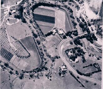
... The aerial photograph shows the market garden situated on the river bend and flat of the Deep Creek at Bulla. In the 19th Century a hotel occupied the site. After World War II...Hume City Civic Collection 44 Macedon Street Sunbury melbourne The aerial photograph shows the market garden situated on the river bend and flat of the Deep Creek at Bulla. In the 19th Century a hotel occupied the site. After World War II ...The aerial photograph shows the market garden situated on the river bend and flat of the Deep Creek at Bulla. In the 19th Century a hotel occupied the site. After World War II the property was owned by the Hughes family, who grew flowers. In 1971 Andrew Vlass purchased the property and it became a market garden until the Vlass family sold it in 1990.A black and white aerial photograph of the river bend and river flat of the Deep Creek at Bulla.scale - 170 feet = 1 inchdeep creek, market gardens, sunbury road, bulla, horticulture, hughes family, vlass, andrew, hotels, george evans collection -
 Ballarat Heritage Services
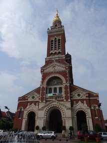
Photograph - Phtotograph - Colour, Ann Gervasoni, Church at Albert, The Somme, France, 2014, 23/07/2014
... war. The underground shelters in which the museum is located served as protective bunkers for Albert's residents during aerial bombardments in World War II. (Wikipedia) albert church the somme world war one Photographs ...Albert was founded as a Roman outpost, in about 54 BC. After being known by various forms of the name of the local river, the Ancre, it was renamed to Albert after it passed to Charles d'Albert, duc de Luynes. It was a key location in the Battle of the Somme in World War I, and World War I tourism is important for the town. During World War I, the statue of Mary and the infant Jesus – designed by sculptor Albert Roze and dubbed the Golden Virgin – on top of the Basilica of Our Lady of Brebières was hit by a shell on 15 January 1915 and slumped to a near-horizontal position, where however it remained until further shelling in 1918 destroyed the tower. The German army recaptured the town in March 1918 during the Spring Offensive; the British, to prevent the Germans from using the church tower as a machine gun post, bombarded and destroyed the basilica.[5] The statue fell in April 1918 and was never recovered. Albert was completely reconstructed after the war, including widening and re-orienting the town's main streets. The Basilica, however, was faithfully rebuilt according to its original design by Eduoard Duthoit, the son of the architect who had overseen its construction in 1885–1895. The present statue is an exact replica of Roze's original design, and a war memorial designed by Roze and featuring an image of the Leaning Virgin can be seen in the Abri (Shelter) Museum, which houses souvenirs of the war. The underground shelters in which the museum is located served as protective bunkers for Albert's residents during aerial bombardments in World War II. (Wikipedia)Photographs of the Church at Albert taken during a tour of the World War One battlefields.albert, church, the somme, world war one -
City of Kingston
Photograph - Colour, Circa 1993
... World War II and in the 1960s. Edithvale is mainly residential with a shopping strip along Nepean Highway but little significant industry was ever established in the area apart from a plaster works and confectionary factory, both now closed. Edithvale Aspendale Chelsea Carrum Carrum Swamp Yellow circular adhesive sticker on plastic Black ink (marker): * (asterisk) Black type on white adhesive sticker: P000108 Aerial colour photograph of Edithvale as viewed from Alexandra Avenue in the north to Ella Grove Chelsea/Edithvale in the south. ...Edithvale is a suburb in the City of Kingston. It is located between Aspendale and Chelsea on the Port Phillip Bay and built within remnant areas of the Carrum Carrum swamp. The foreshore precinct comprises a wide sandy beach, with low sand dunes and numerous historic boat sheds. The suburb consists of older style dwellings and former holiday houses, combined with mid-century housing and newer homes. The large blocks are increasingly subdivided and the existing dwellings demolished to accommodate units and townhouses, thus changing the landscape of the area and reducing the tree canopy.The beachside suburb of Edithvale was previously part of the extensive Carrum Carrum Swamp. The area was once a source of fish and eels for the Mayone-Bulluk clan of the Bunurong people. Over time the area was drained and predominantly devoted to dairy farming and holiday houses. The farms were gradually sold and subdivided with a large number of homes built after World War II and in the 1960s. Edithvale is mainly residential with a shopping strip along Nepean Highway but little significant industry was ever established in the area apart from a plaster works and confectionary factory, both now closed.Aerial colour photograph of Edithvale as viewed from Alexandra Avenue in the north to Ella Grove Chelsea/Edithvale in the south. The area is built-up with residential housing and facilities including Edithvale Primary School, numerous churches and the Edithvale Railway station. Large sections depict the remnant Carrum Carrum swamp. Edithvale Common and the former "Duck Inn" (Melbourne Water/Friends of Edithvale Seaford Wetlands) can be seen. Edithvale Recreational reserve, the velodrome and Edithvale Public Golf Course are prominent. The image shows vacant land in the area now known as Aspendale Gardens and the newer residential section of Chelsea Heights is not developed. A bike path has been established to cover the secondary drain. The Golf Links Court residential development located off Hughes Avenue is a large vacant block.Yellow circular adhesive sticker on plastic Black ink (marker): * (asterisk) Black type on white adhesive sticker: P000108edithvale, aspendale, chelsea, carrum carrum swamp -
City of Kingston
Photograph - Colour, 6 March 1993
... World War II and in the 1960s. Edithvale is mainly residential with a shopping strip along Nepean Highway but little significant industry was ever established in the area apart from a plaster works and confectionary factory, both now closed. Edthvale Carrum Carrum Swamp Aspendale Chelsea Black type on white adhesive label: 6-3-93 Black type on white adhesive label: 25/9211, 6/3/93, 11.20 am Black type on white adhesive label: 9211 Yellow circular adhesive sticker Black pencil: 9211 6-3-93 arrow pointing N Laminated aerial colour photograph of Edithvale as viewed from Alexandra Avenue in the north to Ella Grove Chelsea/Edithvale in the south. regents Park Aspendale can be seen in the top left. ...Edithvale is a suburb in the City of Kingston. It is located between Aspendale and Chelsea on the Port Phillip Bay and built within remnant areas of the Carrum Carrum swamp. The foreshore precinct comprises a wide sandy beach, with low sand dunes and numerous historic boat sheds. The suburb consists of older style dwellings and former holiday houses, combined with mid-century housing and newer homes. The large blocks are increasingly subdivided and the existing dwellings demolished to accommodate units and townhouses, thus changing the landscape of the area and reducing the tree canopy.The beachside suburb of Edithvale was previously part of the extensive Carrum Carrum Swamp. The area was once a source of fish and eels for the Mayone-Bulluk clan of the Bunurong people. Over time the area was drained and predominantly devoted to dairy farming and holiday houses. The farms were gradually sold and subdivided with a large number of homes built after World War II and in the 1960s. Edithvale is mainly residential with a shopping strip along Nepean Highway but little significant industry was ever established in the area apart from a plaster works and confectionary factory, both now closed.Laminated aerial colour photograph of Edithvale as viewed from Alexandra Avenue in the north to Ella Grove Chelsea/Edithvale in the south. regents Park Aspendale can be seen in the top left. The area is built-up with residential housing and facilities including Edithvale Primary School, numerous churches and the Edithvale Railway station. Large sections depict the remnant Carrum Carrum swamp. Edithvale Common and the former "Duck Inn" (Melbourne Water/Friends of Edithvale Seaford Wetlands) can be seen. Edithvale Recreational reserve, the valodrome and Edithvale Public Golf Course are prominent. The image shows vacant land in the area now known as Aspendale Gardens and the newer residential section of Chelsea Heights is not developed. A bike path has been established to cover the secondary drain. The Golf Links Court residential development located off Hughes Avenue is a large vacant block.Black type on white adhesive label: 6-3-93 Black type on white adhesive label: 25/9211, 6/3/93, 11.20 am Black type on white adhesive label: 9211 Yellow circular adhesive sticker Black pencil: 9211 6-3-93 arrow pointing Nedthvale, carrum carrum swamp, aspendale, chelsea