Showing 9 items matching "worlingworth"
-
 Eltham District Historical Society Inc
Booklet, Worlingworth, 10-26 Banoon Road, Eltham, Victoria, 1928, 1928
... Worlingworth, 10-26 Banoon Road, Eltham, Victoria, 1928......Worlingworth...Photographic reproduction of book "Worlingworth", Eltham, home of noted anthropologist the late Professor Donald Thomson ...Eltham District Historical Society Inc 728 Main Rd Eltham melbourne Photographic reproduction of book "Worlingworth", Eltham, home of noted anthropologist the late Professor Donald Thomson Banoon Road Donald Thomson Worlingworth houses Nine-page booklet Worlingworth, 10-26 Banoon Road, Eltham, Victoria, 1928 Booklet Reg. ...Photographic reproduction of book "Worlingworth", Eltham, home of noted anthropologist the late Professor Donald Thomson Nine-page bookletbanoon road, donald thomson, worlingworth, houses -
 Eltham District Historical Society Inc
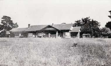
Photograph, Worlingworth, 10-26 Banoon Road, Eltham, Victoria, 1928, 1928
... Worlingworth, 10-26 Banoon Road, Eltham, Victoria, 1928......worlingworth...Extracted from book "Worlingworth", Eltham, home of noted anthropologist the late Professor Donald Thomson ...Eltham District Historical Society Inc 728 Main Rd Eltham melbourne Extracted from book "Worlingworth", Eltham, home of noted anthropologist the late Professor Donald Thomson banoon road donald thomson worlingworth houses Six black and white photographs Worlingworth, 10-26 Banoon Road, Eltham, Victoria, 1928 Photograph ...Extracted from book "Worlingworth", Eltham, home of noted anthropologist the late Professor Donald Thomson Six black and white photographsbanoon road, donald thomson, worlingworth, houses -
 Eltham District Historical Society Inc
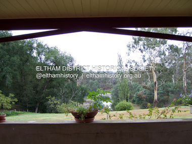
Photograph - Digital Photograph, Marguerite Marshall, View of the Yarra River from 'Worlingworth', 10-26 Banoon Road, Eltham, 30 January 2006
... View of the Yarra River from 'Worlingworth', 10-26 Banoon Road, Eltham......Worlingworth...'Worlingworth', Eltham, home of noted anthropologist the late Professor Donald Thomson and his wife Dorita Thomson. ...Eltham District Historical Society Inc 728 Main Rd Eltham melbourne 'Worlingworth', Eltham, home of noted anthropologist the late Professor Donald Thomson and his wife Dorita Thomson. ...'Worlingworth', Eltham, home of noted anthropologist the late Professor Donald Thomson and his wife Dorita Thomson. Covered under Heritage Overlay, Nillumbik Planning Scheme. Published: Nillumbik Now and Then / Marguerite Marshall 2008; photographs Alan King with Marguerite Marshall.; p127This collection of almost 130 photos about places and people within the Shire of Nillumbik, an urban and rural municipality in Melbourne's north, contributes to an understanding of the history of the Shire. Published in 2008 immediately prior to the Black Saturday bushfires of February 7, 2009, it documents sites that were impacted, and in some cases destroyed by the fires. It includes photographs taken especially for the publication, creating a unique time capsule representing the Shire in the early 21st century. It remains the most recent comprehenesive publication devoted to the Shire's history connecting local residents to the past. nillumbik now and then (marshall-king) collection, banoon road, donald thomson, dorita thomson, eltham, worlingworth -
 Eltham District Historical Society Inc
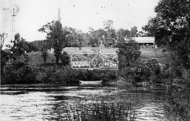
Negative - Photograph, ‘Worlingworth’, Yarra River, Eltham
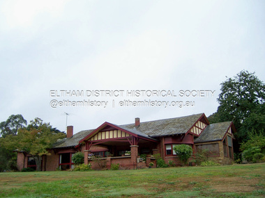
... ‘Worlingworth’, Yarra River, Eltham......worlingworth...‘Worlingworth’, Yarra River, Eltham Original homestead on the property ‘Worlingworth’, a large residence and surrounding farm site standing on a knoll above the River Yarra in Banoon Road, Eltham. ...Eltham District Historical Society Inc 728 Main Rd Eltham melbourne ‘Worlingworth’, Yarra River, Eltham Original homestead on the property ‘Worlingworth’, a large residence and surrounding farm site standing on a knoll above the River Yarra in Banoon Road, Eltham. ...‘Worlingworth’, Yarra River, Eltham Original homestead on the property ‘Worlingworth’, a large residence and surrounding farm site standing on a knoll above the River Yarra in Banoon Road, Eltham. The present house was built about 1922 and was originally owned by Mr A.R. Read, a stock and station agent and member of the Stock Exchange (who left the district in early 1926 to take up permanent residence at his Warburton property). It became the home of notable anthropologist Prof. Dr. Donald Thomson (1901-1971) and Mrs. Gladys Thomson who were married in 1925 and had twin sons in 1934 and is considered historically and aesthetically significant to the Shire of Nillumbik.This photo forms part of a collection of photographs gathered by the Shire of Eltham for their centenary project book, "Pioneers and Painters: 100 years of the Shire of Eltham" by Alan Marshall (1971). The collection of over 500 images is held in partnership between Eltham District Historical Society and Yarra Plenty Regional Library (Eltham Library) and is now formally known as 'The Shire of Eltham Pioneers Photograph Collection.' It is significant in being the first community sourced collection representing the places and people of the Shire's first one hundred years.Digital image 4 x 5 inch B&W Negshire of eltham pioneers photograph collection, a.r. read, banoon road, donald thomson, eltham, gladys thomson, worlingworth, yarra river -
 Eltham District Historical Society Inc
Photograph - Digital Photograph, Marguerite Marshall, 'Worlingworth', 10-26 Banoon Road, Eltham, 30 January 2006
... 'Worlingworth', 10-26 Banoon Road, Eltham......Worlingworth...'Worlingworth', Eltham, home of noted anthropologist the late Professor Donald Thomson and his wife Dorita Thomson. ...Eltham District Historical Society Inc 728 Main Rd Eltham melbourne 'Worlingworth', Eltham, home of noted anthropologist the late Professor Donald Thomson and his wife Dorita Thomson. ...'Worlingworth', Eltham, home of noted anthropologist the late Professor Donald Thomson and his wife Dorita Thomson. Covered under Heritage Overlay, Nillumbik Planning Scheme. Published: Nillumbik Now and Then / Marguerite Marshall 2008; photographs Alan King with Marguerite Marshall.; p127 Dubbed as ‘Australia’s Lawrence of Arabia’ anthropologist Donald Thomson lived much of his life in Eltham, at Banoon Road. On his retirement as Professor of Anthropology in 1968, The University of Melbourne professorial board compared Thomson to Lawrence of Arabia because of his work for Aborigines and his controversial personality. Although Thomson is now recognised for his huge contribution, during his lifetime he suffered opposition and his life has been described as ‘tragic’.1 Thomson failed to gain the recognition as a scientist that he felt he deserved and he failed to alter government policy towards Aboriginal people. But towards the end of his life in 1970, anthropologists were moving towards the type of research he had done and the movement to grant land rights to Aborigines was strengthening. Thomson is best known for his anthropological fieldwork in Cape York, Arnhem Land and Central Australia, but he is also known for his scholarly contributions to ornithology and ecology. Thomson documented every aspect of the daily and ritual life of the Aboriginal world of Cape York and Arnhem Land in the 1930s and 1940s. The huge collection in Museum Victoria includes 11,000 photographs, 7500 items of material culture, 1000 botanical and zoological specimens and 4500 pages of field-notes.2 The film Ten Canoes used Thomson’s photographs as a source. Thomson bought the Eltham property known as Worlingworth in 1934. The single-storey 60-square house standing by the Yarra River was built in 1922-23. It is one of the last in Eltham to survive with its farm setting intact. It is also one of the few substantial residences built in the Eltham Shire from the late 19th century to the early 20th century, which signalled a major change in the area towards the residential municipality it is today.3 The original section, built in the mid 1860s, of rose pink hand-made bricks and stone quarried on the property, was incorporated in the new red-brick house built in 1922. An immense oak tree by the house grew from an acorn brought by Patrick Armstrong who first bought the land in March 14, 1862. Armstrong named Worlingworth after his forbears’ village in Suffolk, England. Worlingworth saw grand days when Commander Alan A Barlee (R.N.) bought it in 1922 after winning the Calcutta Sweep. The property then included a nine-hole golf course, a tennis court, a bowling green, a boathouse and a boat-ramp.4 For most of his career Thomson, who was born in 1901, was attached to The University of Melbourne. In 1935 he represented the Commonwealth Government at Caledon Bay in east Arnhem Land to investigate and mediate for four Aborigines accused of killing five Japanese and three Europeans. In 1938 Thomson was awarded a PhD in Anthropology at Cambridge University, and during his career, he received several medals from British Societies, who perhaps appreciated his work better than their Australian counterparts. From World War Two, Thomson suffered a string of hardships, beginning with severe wounding in Dutch New Guinea (for his military service in New Guinea he was awarded an OBE) and he was invalided from service in 1944. That year he was diagnosed with diabetes. A fire in 1946 destroyed what Thomson regarded as perhaps the best record he had made of Aboriginal life – the 20,000 feet, (6096m) of film he had shot in Arnhem Land. In 1954 he and wife, Gladys, divorced. The next year he married his technical assistant, Dorita McColl. Several times during his career Thomson had major disagreements. For instance Professor P Elkin constantly opposed his work. He also opposed Thomson when he campaigned vigorously in 1947 against the establishment of a rocket range at Woomera, South Australia, because of the threat it posed Aborigines. Thomson resigned in frustration from the Victorian Aborigines Welfare Board in 1967, after serving for ten years, because he found that his advice was disregarded. His ashes were scattered over Caledon Bay from the air.This collection of almost 130 photos about places and people within the Shire of Nillumbik, an urban and rural municipality in Melbourne's north, contributes to an understanding of the history of the Shire. Published in 2008 immediately prior to the Black Saturday bushfires of February 7, 2009, it documents sites that were impacted, and in some cases destroyed by the fires. It includes photographs taken especially for the publication, creating a unique time capsule representing the Shire in the early 21st century. It remains the most recent comprehenesive publication devoted to the Shire's history connecting local residents to the past. nillumbik now and then (marshall-king) collection, banoon road, donald thomson, dorita thomson, eltham, worlingworth -
 Eltham District Historical Society Inc
Negative - Photograph, J.A. McDonald, Eltham, Haldane Road, Mar. 1961
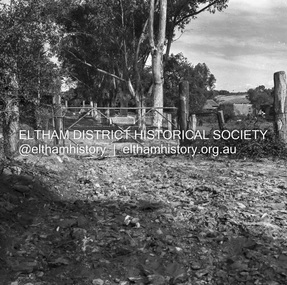
... ...Worlingworth...Dr Donald Thomson's gate and entrance to his property 'Worlingworth' after flooding in March 1961 "Worlingworth", Eltham, was the home of noted anthropologist the late Professor Donald Thomson and his wife Dorita. ...Eltham District Historical Society Inc 728 Main Rd Eltham melbourne Dr Donald Thomson's gate and entrance to his property 'Worlingworth' after flooding in March 1961 "Worlingworth", Eltham, was the home of noted anthropologist the late Professor Donald Thomson and his wife Dorita. ...Dr Donald Thomson's gate and entrance to his property 'Worlingworth' after flooding in March 1961 "Worlingworth", Eltham, was the home of noted anthropologist the late Professor Donald Thomson and his wife Dorita. The entrance gate on Banoon Road is located at the bottom of the hill opposite Haldane Road. The flooding issues were regularly reported to Council following heavy rain. Google Street View Feb 2014 https://goo.gl/maps/SGjsJAAEdjQXgo5V9Record of various Shire of Eltham infrastructure works undertaken during the period of 1952-1962 involving bridge and road reconstruction projects, sometimes with Eltham Shire Council Project Reference numbers quoted. It was during this period that a number of significant improvements were made to roads and new bridges constructed within the shire that remain in place as of present day (2022). In many situations, the photos provide a tangible visible record of infrastructure that existed throughout the early days of the Shire. The album was put together by or under the direction of the Shire Engineer, J.A. McDonald.infrastructure, shire of eltham, 1961-03, flood damage, haldane road, prof donald thomson, worlingworth -
 Eltham District Historical Society Inc
Document - Folder, Thomson, Donald
... Photocopy of old photograph of "Worlingworth", home of Donald Thomson. Booklet: "N.T.S.R.U. 1941-1943: text and photographs from the report of Sqn Leader Donald Thomson." ...Photocopy of old photograph of "Worlingworth", home of Donald Thomson. Booklet: "N.T.S.R.U. 1941-1943: text and photographs from the report of Sqn Leader Donald Thomson." ...Anthropologist and Aboriginal activist Donald Thomson later lived in Eltham with wife Dorita. Contents Photocopy of photograph of Thomson family at "The Oaks", Kinglate 11 November 1891. Photocopy of old photograph of "Worlingworth", home of Donald Thomson. Booklet: "N.T.S.R.U. 1941-1943: text and photographs from the report of Sqn Leader Donald Thomson." Yirrkale Literature Production Centre, 1992. Photocopy of Australian Dictionary of Biography (Vol.16, pp385-386), entry for Thomson, Donald Finlay Fergusson. Newspaper article: "Drought close to city", no source, no date. Donald Thomson wants South Riding of Eltham declared a drought area, photograph of Elaine Thomson. Newspaper article: "Professor dies", The Post, 27 1970. Obituary of Donald Thomson. Photocopy of extracts from "Donald Thomson in Arnhem Land" 1983: Chapter "Donald Thomson: A biographical Sketch". pp1-15; Map; Notes on sources pp141-142. Newspaper article: "Memoirs of an advocate for Aboriginal rights", Diamond Valley News, 8 March 1983. Interview of Dorita Thomson, widow of Donald Thomson, about him and house "Worlingworth". Newspaper article: "Australia's secret Aboriginal 'army". Herald, 2 June 1983. Donald Thomson's life and work, and the book about it, "Donald Thomson of Arnhem Land". Invitation to exhibition of photographs by Donald Thomson, Brighton City Library, 22 July 1983. Publicity for film "Thomson of Arnhem Land" with note from Bruce Nixon, 8 June 2000. Newspaper article: "A crusader before his time", Diamond Valley News, 9 August 2000. Details of life and work of Donald Thomson. Newspaper article: "Outback part. of his life", Diamond Valley News, 9 August 2000. Interview of Dorita Thomson about Donald Thomson's life and work. Newspaper article: "Museum and Aboriginies to meet in stand-off over heritage items", The Age, 29 July 2004. Bark paintings on loan from British Museum in dispute. Magazine article: "Keeping time with Rolf", Time, 20 March 2006. Mentions of Donald Thomson. Newspaper advertisement: "The Thomson House" Templestowe, Emerson Oliver Estate Agent. The Weekly Review, no date (possibly 2017). Flier: "The Thomson House" Templestowe, Emerson Oliver Estate Agent. Newspaper article: "Once upon a time an anthropolgist watched men hunt in 10 canoes", The Age, 16 December 2006. Donald Thomson's work and a new film "Ten Canoes". Newspaper article: "A life's work offers forgotten link to the cultural wealth of nation's first people", The Age, 23 December 2024. The Donald Thomson Ethnohistory Collection. Newspaper clippings, A4 photocopies, etcdonald thomson, northern territory special reconnaissance unit, donald finlay fergusson thomson, "the oaks" kinglake, "worlingworth" eltham, elaine thomson, louise thomson, rosemary thomson, dorita thomson, st margaret's church of england eltham, australian institute of aboriginal studies, brandy creek gippsland, ."donald tomson in arnhem land"., "n.t.s.r.u. 1941-1943", "thomson of arnhem land", victorian aborigines welfare board, thomson collection museum victoria, mia mia aboriginal art gallery, louise thomson-officer, marcia langton, su baker, lake tyers victorian aboriginal reserve gippsland, robert macklin, yintjingga people, 29 edwin road templestowe, royal geographic society, nicholas peterson, mapoon mission, wongo aboriginal man, wuluwirr aboriiginal man, mattuwa aboriginal man, mauwunbol aboriginal man, munguyuma aboriginal man, dja dja wurrung people, gavin jennings, gary murray, film "ten canoes", galanbingu people, mandallpuy people, djinba people, rolf de heer, arnhem land, arafura swamp, ramingining, caledon bay, lindy allen, bunjilaka centre -
 Eltham District Historical Society Inc
Postcard - Photograph postcard, The Rapids, Devils' Bank, Eltham, 1907
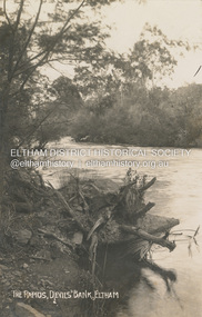
... Only three properties existed in this area in 1945 aerial maps, Worlingworth and the adjoining property on the bank of the Diamond Creek in Banoon Road and No. 2 Kent Hughes Road. ...Only three properties existed in this area in 1945 aerial maps, Worlingworth and the adjoining property on the bank of the Diamond Creek in Banoon Road and No. 2 Kent Hughes Road. ...Devils' Bank was situated some two miles from Eltham. It is probably the section along the Yarra River where there are a series of rapids stretching past Petty's Orchard to Griffiths Park and the confluence with the Diamond Creek. Only three properties existed in this area in 1945 aerial maps, Worlingworth and the adjoining property on the bank of the Diamond Creek in Banoon Road and No. 2 Kent Hughes Road. Devils' Bank. The death of Ann Edwards, 77 years, an old resident of the district was reported who lived in an old hut at Devil's Bank who had been found dead in her bed on 13 May 1897 FOUND DEAD IN BED. (1897, May 28). Evelyn Observer, and South and East Bourke Record (Vic. : 1882 - 1902), p. 2 (MORNING.). Retrieved September 3, 2022, from http://nla.gov.au/nla.news-article60696388 A very similar view was published in the Leader paper in January 1908 - Devil's Bank Falls, Eltham VIEWS ON THE UPPER YARRA. (1908, January 11). Leader (Melbourne, Vic. : 1862 - 1918, 1935), p. 28. Retrieved September 3, 2022, from http://nla.gov.au/nla.news-article198106006 On the reverse of the postcard it appears to be postmarked Eltham, Dec 27, 1907 addressed to Mrs Christie Millmoss of Bull Street, Bendigo "Arrived here 10.45 am - ? ? raining cause of ? - ? till evenings it is lovely - but quite fresh after the (rain - crossed out) great ? - I may assume it all go well"Digital file only Postcards scanned from the collection of Michael Aitken on loan to EDHS, 2 Sep. 2022michael aitken collection, devils bank, eltham, postcards, rapids, yarra river -
 Eltham District Historical Society Inc
Album - Photograph Album, J.A. McDonald, Bridge and Road Reconstruction Works, Shire of Eltham, 1952-1962
... ...Worlingworth...Wolf Waterfall property Watsons Creek Wattletree Road Bridge Wattletree Road Wattletree Road Bridge Worlingworth Yarra Glen York Street yow yow creek 78 foolscap pages containing a sequence of photos, adhered via glue or sticky tape, with typed or handwritten headings and captions in pencil. ...J.A. McDonald produced this record in the course of his responsibilities as Shire Engineer for Eltham Shire Council.Record of various Shire of Eltham infrastructure works undertaken during the period of 1952-1962 involving bridge and road reconstruction projects, sometimes with Eltham Shire Council Project Reference numbers quoted. It was during this period that a number of significant improvements were made to roads and new bridges constructed within the shire that remain in place as of present day (2022). In many situations, the photos provide a tangible visible record of infrastructure that existed throughout the early days of the Shire. The album was put together by or under the direction of the Shire Engineer, J.A. McDonald.a. gillies, alistair knox park, benchmark studies, bend of islands, blease road, box hill state school, box hill teachers college, box hill tip, bridge construction, bridge street bridge, bridge, brisbane street, brougham steet, bulldozer, cecil street, charis pelling, cherry tree road, city of preston, cr. a. brinkkotter, cr. charis pelling, cranes, cromwell street, diamond creek (creek), diamond street, dixons creek bridge, dixon's creek road, drott, eltham leisure centre, eltham north, eltham police station, eltham, eltham-yarra glen road, f. wood, fitzsimons lane bridge, flat rock road, flood damage, floods, floodwater, footpaths and gutters, ford service garage, g. blair, garden hill, glen park bridge, glenauburn road, grand hotel, haldane road, healesville, healesville-yarra glen road, heidelberg-kinglake road, henley road bridge, henley road, hill property, hurstbridge water scheme, hurstbridge, hurstbridge-arthurs creek road, infrastructure, j. jolly, kangaroo ground, kangaroo ground-queenstown road, kangaroo ground-st andrews road, lilydale shire office, long gully bridge, long gully creek, long gully road, long gully, lower plenty bridge, lower plenty footbridge, lower plenty oval, lower plenty road, lower plenty, main road, methodist church, montmorency, mount pleasant road, new holland, old healesville road, opening ceremony, oxley bridge, para road, paul creek bridge, paul creek road, paul krafeznk, pinnacle lane, plaques, plenty river trail, plenty river, presbyterian church, prof donald thomson, pryor street, railway crossing, railway parade, rattray road, reconstruction works, reichelt avenue, research (vic.), research oval, road construction, rymers corner, shire of eltham, shire of whittlesea, silvan road bridge, silver street bridge, silver street, sir dallas brooks, smedley property, st andrews, steels creek, susan street, tarrawarra, tony carberry, uniting church, upper yarra dam, upper yarra reservoir, w.e. wolf, waterfall property, watsons creek, wattletree road bridge, wattletree road, wattletree road bridge, worlingworth, yarra glen, york street, yow yow creek