Showing 41 items matching "wurundjeri council"
-
 Victorian Aboriginal Corporation for Languages
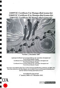
Book, 21859VIC Certificate I in Mumgu-dhal tyama-tiyt 21860VIC Certificate II in Mumgu-dhal tyama-tiyt 21861VIC Certificate III in Mumgu-dhal tyama-tiyt, 2007
... ...Wurundjeri Council...Victorian Aboriginal Corporation for Languages 33 Saxon Street Brunswick melbourne Woiwurrung Keeraywooroong Keerraywoorroong Wurundjeri Council curriculum course guide 21859VIC Certificate I in Mumgu-dhal tyama-tiyt 21860VIC Certificate II in Mumgu-dhal tyama-tiyt 21861VIC Certificate III in Mumgu-dhal tyama-tiyt Book Service Industries Curriculum Maintenance Manager - General Studies and Further Education, Victoria University ...woiwurrung, keeraywooroong, keerraywoorroong, wurundjeri council, curriculum, course guide -
 Greensborough Historical Society
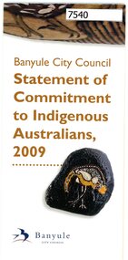
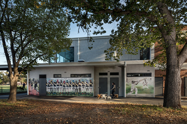
Poster, Banyule City Council, Statement of commitment to Indigenous Australians 2009: Banyule City Council, 2009
... council...wurundjeri willam...Greensborough Historical Society 34A Glenauburn Road Lower Plenty Lower Plenty melbourne A brief history of Banyule Council's commitment to Indigenous Australians and the 2009 statement of commitment. indigenous australians banyule council wurundjeri willam Poster, folded in 6 to pamphlet size. ...A brief history of Banyule Council's commitment to Indigenous Australians and the 2009 statement of commitment.Poster, folded in 6 to pamphlet size. Text and colour images.indigenous australians, banyule council, wurundjeri willam -
 Greensborough Historical Society
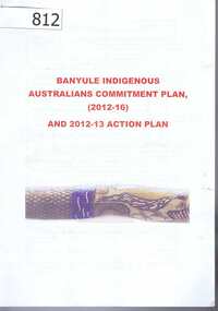
Planning Document, Banyule Indigenous Australians Commitment Plan (2012-2016) and 2012-13 Action Plan, 2012-2016
... council...wurundjeri willam...Contains a short history of the Wurundjeri willam, traditional owners of Banyule. Outlines the Banyule Council's Statement of Commitment to Indigenous members of the community....This document contains both historical information and a plan for moving forward in identifying and promoting the culture and heritage of the Wurundjeri willam in Banyule. banyule city council wurundjeri willam indigenous heritage in banyule Banyule Indigenous Australians Commitment Plan (2012-2016) and 2012-13 Action Plan. ...Contains a short history of the Wurundjeri willam, traditional owners of Banyule. Outlines the Banyule Council's Statement of Commitment to Indigenous members of the community.This document contains both historical information and a plan for moving forward in identifying and promoting the culture and heritage of the Wurundjeri willam in Banyule.banyule city council, wurundjeri willam, indigenous heritage in banyule -
 Sunbury Family History and Heritage Society Inc.
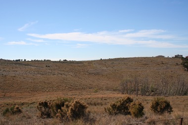
Photograph, Rosa McCall, Sunbury Cultural Ring, May 2018
... They are owned and managed by the Wurundjeri Tribe Land Council....They are owned and managed by the Wurundjeri Tribe Land Council. The rings bear evidence of Aboriginal settlement and land use in the area. ...The photograph is of one of the Sunbury Cultural Rings sites. There are three Aboriginal earthen rings. The one in the foreground which is clear of weeds has been formed as a round dip in the earth and it is thought it was used as an Aboriginal gathering place. They are owned and managed by the Wurundjeri Tribe Land Council.The rings bear evidence of Aboriginal settlement and land use in the area. A coloured landscape photograph of open grassland and hills across the valley with a few native trees growing . aboriginal cultural rings, sunbury, jacksons creek, wurundjeri people -
 Eltham District Historical Society Inc
Photograph, Fay Bridge, Eastern boundary of former Warrandyte Aboriginal Reserve, North Warrandyte, 7 November 2016
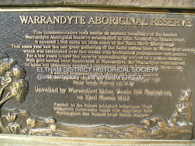
... Two bronze commemorative plaques on rocks, unveiled by Wurundjeri Tribe Council Elders, mark two eastern boundaries of the former Warrandyte Aboriginal Reserve on the north and south sides of the Yarra. ...Eltham District Historical Society Inc 728 Main Rd Eltham melbourne Two bronze commemorative plaques on rocks, unveiled by Wurundjeri Tribe Council Elders, mark two eastern boundaries of the former Warrandyte Aboriginal Reserve on the north and south sides of the Yarra. ...Two bronze commemorative plaques on rocks, unveiled by Wurundjeri Tribe Council Elders, mark two eastern boundaries of the former Warrandyte Aboriginal Reserve on the north and south sides of the Yarra. This project was initiated by Nillumbik Reconciliation Group in close association with Reconciliation Manningham and the Wurundjeri Tribe Council, as a means of commemorating the last great corroboree of the Kulin Nation which was held at Pound Bend in March 1852. This plaque is on the Nillumbuk side of the Yarra, accessed via The Boulevard, North Warrandyte. The plaque is set on a rock approximately 50 metres before the turning circle at the end of The Boulevard. Plaque : Warrandyte Aboriginal Reserve This commemorative rock marks an eastern boundary of the former Warrandyte Aboriginal Reserve established in 1852. Centred on Pound Bend, it covered 1,908 acres on both sides of the Yarra River (Birrarung). That same year saw the last great gathering of the Kulin nation here in Wurundjeri country which was celebrated over two weeks with traditional performance and games. For a few years longer the reserve intermittently served as a ration station.With gold having been discovered at Warrandyte, the Wurundjeri were moved on again but ultimately secured a permanent home at Coranderrk, Healesville. A second commemorative plaque and rock is located on the opposite bank of the Yarra and its confluence with Stony Creek. Melway ref : 23 C 9 Unveiled by Wurundjeri Elder, Uncle Bill Nicholson on 23rd March 2013 Funded by the Robert Bridgford Indigenous Trust (Nillumbik Community Fund) with assistance from Manningham City Council Small Grants Program Ref: Monument Autralia https://monumentaustralia.org.au/themes/culture/indigenous/display/99680-warrandyte-aboriginal-reserve-fay bridge collection, 2016-11-07, aboriginal reserve, north warrandyte, plaques, warrandyte aboriginal reserve -
 Eltham District Historical Society Inc
Film - Video (VHS), Nillumbik Shire Council, The Nillumbik Story, 1996
... CREDITS Music by John Greenfield from the CD Sweet Rain “The Snow Tree”, Uncle Music UNC 2001 Cameras - David Mirabella and Peter Farragher Editor – Olwyn Jones Written and Produced by Jason Cameron A Jason Cameron Proction for Nillumbik Shire Provides a record of the relatively newly created Shire of Nillumbik at the time and the features and attactions of the shire in its people arts, culture and environment video recording Arthurs Creek Arthurs Creek Landcare group Artists artists in residence Arts Arts Festival Authors BlackBerry Brock family Bulldozer Bulleen bushland sanctuary Caledonian gold rush Charles Reddington Clifton Pugh cottlesbridge Cypress rows developer Diamond Creek Diamond Creek Mine Diamond Reef Diamond Valley miniature railway Doncaster dunmoochin Education program EEPS Eltham Eltham East Primary School Eltham East Primary School Band Eltham Library Community Gallery Eltham Lower Park Environment fishing flour mill fruit growing fruiterer Garden Hill Gold mining Green Wedge Greensborough Heritage Trail Hurstbridge Railway Line jazz festival Jock Ryan Kangaroo Ground kangaroo ground tower Kinglake Maroondah Aqueduct Matcham Skipper Memorial Park Ming Mackay (1918-2009) Montsalvat Mudbrick houses Music musicians nesting area Nillumbik Historical Society Nillumbik Shire North Warrandyte Old timer Orchards Peter Brock Plenty River poets Population Recreation recreational activities revegetation Robert Hoddle Sandy Brock Shillinglaw Cottage Shire of Eltham War Memorial Sigmund Jorgensen St Andrews Hotel St Andrews Market Sugarloaf Reservoir Templestowe The Hill tourism Viewing platform Warrandyte water catchment area Watsons Creek Wedgetail eagle Whittlesea Wiregrass Gallery Wurundjeri Yarra River Jack Powell VHS Cassette (five copies) DVD (one copy) Converted to MP4 file format 0:22:00, 1.60GB The Nillumbik Story Film Video (VHS) Nillumbik Shire Council Jason Cameron David Mirabella Peter Farragher Olwyn Jones ...PART 1 – NILLUMBIK (00:00-07:17) Opening features various scenes around Nillumbik Shire. For 40,000 years Nillumbik was the home of the Wurundjeri people. Robert Hoddle gave the district its name. Jock Ryan, then president of Nillumbik Historical Society discusses the names Nillumbik and Diamond Creek. In the late 1830s white occupation began with gold found in Warrandyte in 1851 and 12 years later at Diamond Creek -the Diamond Reef which led to the Caledonian gold rush. Jock Ryan discusses the Diamond Creek mine, which was thriving until it burnt out in 1915. Large numbers of workmen moved into area in late 1870s to construct the Maroondah Aqueduct. With growing population of Melbourne, the nearby Yan Yean system had severely disrupted the flow of the Plenty River, forcing the closure of three flour mills there. The aqueduct came to the rescue carrying water 66km from Healesville to Preston. When the Diamond Creek gold mine burnt down the local economy suffered but fruit growing industry had already been established and Diamond Creek became a thriving fruit growing centre. Interview with Jack Powell, a long-time fruiterer at St Andrews market, his family had lived in the area for a hundred years, 3 to 4 generations, “a lot of hard work”. By the time the railway arrived fruit growing was no longer competitive. The railway brought the city closer and day trippers. The Green Wedge separates the shire from the more densely developed neighbours such as Whittlesea, Doncaster, Templestowe, Bulleen and Greensborough. Population at the time (1996) was 19,000 but links to the past remain strong. Mudbrick houses along the Heritage Trail The saving of Shillinglaw Cottage from demolition in 1963 and relocation brick by brick. PART 2 – ENVIRONMENT (07:18-14:44) Peter Brock (with Bev Brock in background) at St Andrews market discusses his childhood growing up in the district and the environment and the values it instilled upon him and his own family. The Brocks have been in the district since the 1860s. Nillumbik Shire responsible for managing three catchment areas; Diamond Creek, Arthurs Creek and Watsons Creek. Follows the course of the Diamond Creek commencing in Kinglake through the district to its confluence with the Yarra River at Eltham at Eltham Lower Park. Highlights Eltham Lower Park community revegetation program and the newly constructed (1996) viewing platform built of new and recycled timbers at the confluence of the Diamond Creek and Yarra River. Also featured are outdoor recreation on the river and at Eltham Lower Park including the Diamond Valley miniature railway. Sugarloaf reservoir and recreational activities and fishing. Aerial view of Memorial Park and Shire of Eltham War Memorial tower at Garden Hill, Kangaroo Ground. Significant tourism opportunities for the shire with 3 million potential day-trippers in metropolitan Melbourne. Council and community working together to find a way to promote the shires natural and artistic assets. At Arthurs Creek, the Brock family and neighbours working together to take care of their waterway. Peter Brock’s uncle, Sandy Brock talks about environmental management and the Arthurs Creek Landcare group and actions to eradicate blackberry problem. Having previously planted Cypress rows they are replacing them with indigenous species to improve the water supply, keeping cattle out of the creek bed to improve the quality downstream flowing into the Yarra. Eltham East Primary School Band playing “All things bright and beautiful” merges into scenes of the bushland sanctuary set aside by the school in 1980 with unidentified teacher discusses the sanctuary and their education program and school children’s comments. Plight of a family of Wedgetail eagles nesting in the path of a developer’s bulldozer at North Warrandyte and actions to save their nesting areas. PART 3 – ARTS (14:45-22:00) Arts and Jazz festival at Montsalvat featuring interviews with Sigmund Jorgensen discussing Montsalvat and its principles. Also Matcham Skipper. Clifton Pugh’s funeral at Montsalvat and his legacy at Dunmoochin near Cottlesbridge with artists in residence, at the time, Chicago artist Charles Reddington who discusses the benefits of the experience. An unidentified female artist also talks about the program and why people are drawn to the area. Unidentified man on street talking about the amount of talent in the area, artists, poets, musicians, authors. Artist Ming Mackay (1918-2009) interviewed talking about the people she mixes with on “the Hill”. Works of local artists are displayed Eltham Library Community Gallery and Wiregrass gallery with a new coffee shop at the Wiregrass making it an even more popular destination. Music at St Andrews Hotel (may be a little bit country) and the Saturday market where likely to hear anything. Sellers and patrons at the market asked about what attracts them to the market and where they came from. Scenes of poets/authors giving readings. CREDITS Music by John Greenfield from the CD Sweet Rain “The Snow Tree”, Uncle Music UNC 2001 Cameras - David Mirabella and Peter Farragher Editor – Olwyn Jones Written and Produced by Jason Cameron A Jason Cameron Proction for Nillumbik ShireProvides a record of the relatively newly created Shire of Nillumbik at the time and the features and attactions of the shire in its people arts, culture and environmentVHS Cassette (five copies) DVD (one copy) Converted to MP4 file format 0:22:00, 1.60GBvideo recording, arthurs creek, arthurs creek landcare group, artists, artists in residence, arts, arts festival, authors, blackberry, brock family, bulldozer, bulleen, bushland sanctuary, caledonian gold rush, charles reddington, clifton pugh, cottlesbridge, cypress rows, developer, diamond creek, diamond creek mine, diamond reef, diamond valley miniature railway, doncaster, dunmoochin, education program, eeps, eltham, eltham east primary school, eltham east primary school band, eltham library community gallery, eltham lower park, environment, fishing, flour mill, fruit growing, fruiterer, garden hill, gold mining, green wedge, greensborough, heritage trail, hurstbridge railway line, jazz festival, jock ryan, kangaroo ground, kangaroo ground tower, kinglake, maroondah aqueduct, matcham skipper, memorial park, ming mackay (1918-2009), montsalvat, mudbrick houses, music, musicians, nesting area, nillumbik historical society, nillumbik shire, north warrandyte, old timer, orchards, peter brock, plenty river, poets, population, recreation, recreational activities, revegetation, robert hoddle, sandy brock, shillinglaw cottage, shire of eltham war memorial, sigmund jorgensen, st andrews hotel, st andrews market, sugarloaf reservoir, templestowe, the hill, tourism, viewing platform, warrandyte, water catchment area, watsons creek, wedgetail eagle, whittlesea, wiregrass gallery, wurundjeri, yarra river, jack powell -
 Eltham District Historical Society Inc
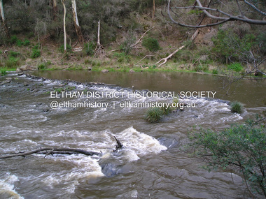
Photograph, Fay Bridge, Ancient Eel trap on the Yarra River at Laughing Waters, Eltham - pre-dating European settlement, 6 September 2023
... Wurundjeri Woi Wurrung Cultural Heritage Aboriginal Corporation - Laughing Waters. (2023, September 3). Retrieved from https://inplace.org.au/laughing-waters/ GARAMBI BAAN LAUGHING WATERS RESIDENCY CENTRE 2020 2024 Strategic Plan, Nillumbik Shire Council (2023, September 3). ...Wurundjeri Woi Wurrung Cultural Heritage Aboriginal Corporation - Laughing Waters. (2023, September 3). Retrieved from https://inplace.org.au/laughing-waters/ GARAMBI BAAN LAUGHING WATERS RESIDENCY CENTRE 2020 2024 Strategic Plan, Nillumbik Shire Council (2023, September 3). ...Laughing Waters is the name for a stretch of the Yarra Valley Parklands consisting of river flats and hilly riparian bushland. With Birrarung (Yarra River) flowing through, Laughing Waters has been an important gathering place for thousands of years. For the Wurundjeri, ‘Garambi Baan’ (the name for Laughing Waters in Woi wurrung) is an important site for growing and harvesting food. Significantly, Wurundjeri iuk (eel) traps remain at Garambi Baan to this day. The Wurundjeri Woi Wurrung People take their name from the Woi wurrung language word ‘wurun’ meaning the Manna Gum (Eucalyptus viminalis) which is common along ‘Birrarung’ (Yarra River), and ‘djeri’, the grub which is found in or near the tree. Wurundjeri are the ‘Manna Gum People’ and their Ancestors have lived on this land for millennia. The site on the Yarra River near the former Morrison property Killeavey was given a language name in 2015 at the instigation of Wurundjeri Elder, Dave Wandin. Garambi Baan means “laughing waters” in the traditional language, Woi wurrung. The site at Warrandyte was rediscovered by Campbell Beardsell OAM in 2007 and is one of only a few known remaining iuk (eel) traps on Country once found the length of the Birrarung (Yarra) and the Maribyrnong. Original Indigenous aquacultural infrastructure was dismantled, taken away from sites and used to build houses, fords and roads by Europeans. The difficult and restricted access to this site is thought to be one of the reasons for its survival. The iuk trap is located within lands managed by Parks Victoria. The Narrap team in partnership with Parks Victoria and Acacia Land Management have been improving the native vegetation with a program of woody weed removal, exclusion fencing and revegetation. Importantly, the team have restored the trap’s infrastructure and have demonstrated its effectiveness.” References: Wurundjeri Woi Wurrung Cultural Heritage Aboriginal Corporation - Laughing Waters. (2023, September 3). Retrieved from https://inplace.org.au/laughing-waters/ GARAMBI BAAN LAUGHING WATERS RESIDENCY CENTRE 2020 2024 Strategic Plan, Nillumbik Shire Council (2023, September 3). Retrieved from https://www.nillumbik.vic.gov.au/files/assets/public/minutes-and-agendas/2020/09-sep/15-sep-cm/ocm.177-20-attachment-1-laughing-waters-arts-program_1.pdffay bridge collection, eel trap, laughing waters, yarra river, wurundjeri woi wurrung, garambi baan, 2023-09-06 -
 Eltham District Historical Society Inc
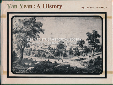
Book, Dianne H. Edwards, Yan Yean: A History, 1978
... Wurundjeri Woi Wurrung Yan Yean Ex Eltham College Library; various library markings Hardback 109p. : ill.(part col.), facs., maps ; 22x29cm. Yan Yean: A History Book Book Dianne H. Edwards Yan Yean School Council ...Wurunjerrai - Baluk tribe in the area; place names.Ex Eltham College Library; various library markings wurundjeri woi wurrung, yan yean -
 Eltham District Historical Society Inc
Photograph, Fay Bridge, Ancient Eel trap on the Yarra River at Laughing Waters, Eltham - pre-dating European settlement, 16 May 2015
... Wurundjeri Woi Wurrung Cultural Heritage Aboriginal Corporation - Laughing Waters. (2023, September 3). Retrieved from https://inplace.org.au/laughing-waters/ GARAMBI BAAN LAUGHING WATERS RESIDENCY CENTRE 2020 2024 Strategic Plan, Nillumbik Shire Council (2023, September 3). ...Wurundjeri Woi Wurrung Cultural Heritage Aboriginal Corporation - Laughing Waters. (2023, September 3). Retrieved from https://inplace.org.au/laughing-waters/ GARAMBI BAAN LAUGHING WATERS RESIDENCY CENTRE 2020 2024 Strategic Plan, Nillumbik Shire Council (2023, September 3). ...Laughing Waters is the name for a stretch of the Yarra Valley Parklands consisting of river flats and hilly riparian bushland. With Birrarung (Yarra River) flowing through, Laughing Waters has been an important gathering place for thousands of years. For the Wurundjeri, ‘Garambi Baan’ (the name for Laughing Waters in Woi wurrung) is an important site for growing and harvesting food. Significantly, Wurundjeri iuk (eel) traps remain at Garambi Baan to this day. The Wurundjeri Woi Wurrung People take their name from the Woi wurrung language word ‘wurun’ meaning the Manna Gum (Eucalyptus viminalis) which is common along ‘Birrarung’ (Yarra River), and ‘djeri’, the grub which is found in or near the tree. Wurundjeri are the ‘Manna Gum People’ and their Ancestors have lived on this land for millennia. The site on the Yarra River near the former Morrison property Killeavey was given a language name in 2015 at the instigation of Wurundjeri Elder, Dave Wandin. Garambi Baan means “laughing waters” in the traditional language, Woi wurrung. The site at Warrandyte was rediscovered by Campbell Beardsell OAM in 2007 and is one of only a few known remaining iuk (eel) traps on Country once found the length of the Birrarung (Yarra) and the Maribyrnong. Original Indigenous aquacultural infrastructure was dismantled, taken away from sites and used to build houses, fords and roads by Europeans. The difficult and restricted access to this site is thought to be one of the reasons for its survival. The iuk trap is located within lands managed by Parks Victoria. The Narrap team in partnership with Parks Victoria and Acacia Land Management have been improving the native vegetation with a program of woody weed removal, exclusion fencing and revegetation. Importantly, the team have restored the trap’s infrastructure and have demonstrated its effectiveness.” References: Wurundjeri Woi Wurrung Cultural Heritage Aboriginal Corporation - Laughing Waters. (2023, September 3). Retrieved from https://inplace.org.au/laughing-waters/ GARAMBI BAAN LAUGHING WATERS RESIDENCY CENTRE 2020 2024 Strategic Plan, Nillumbik Shire Council (2023, September 3). Retrieved from https://www.nillumbik.vic.gov.au/files/assets/public/minutes-and-agendas/2020/09-sep/15-sep-cm/ocm.177-20-attachment-1-laughing-waters-arts-program_1.pdffay bridge collection, 2015-05-16, eel trap, laughing waters, yarra river, wurundjeri woi wurrung, garambi baan -
 Eltham District Historical Society Inc
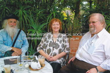
Photograph, Fay Bridge, Book launch of Laughing Waters Road by Jane Woollard at Montsalvat, Eltham, 30 January 2016
... Council funded the book and it was designed by Wayne Rankin of North Warrandyte. The dedication page is to our very own Ranger Campbell Beardsell OAM of Parks Vic who taught Jane to be “passionate about the environment of this special place” (p260). FOWSP members Val Polley, Linda Rogan and Ken Crook contributed to the content and photos. David Wandin, Wurundjeri...Council funded the book and it was designed by Wayne Rankin of North Warrandyte. The dedication page is to our very own Ranger Campbell Beardsell OAM of Parks Vic who taught Jane to be “passionate about the environment of this special place” (p260). FOWSP members Val Polley, Linda Rogan and Ken Crook contributed to the content and photos. David Wandin, Wurundjeri ...Laughing Waters Road , the book was launched at Montsalvat in Eltham. On Saturday, January 30, 2016, Nillumbik Council launched this book. The weather was cool; just as well, considering over 500 people attended this very pleasant event where food and drink were plentiful. The Australian Government and Nillumbik Shire Council funded the book and it was designed by Wayne Rankin of North Warrandyte. The dedication page is to our very own Ranger Campbell Beardsell OAM of Parks Vic who taught Jane to be “passionate about the environment of this special place” (p260). FOWSP members Val Polley, Linda Rogan and Ken Crook contributed to the content and photos. David Wandin, Wurundjeri Elder, gave a Welcome to Country and officially launched the book after the Mayor of Nillumbik, Cr Hattam, made introductions. Jane Woollard followed with a brief outline of how she came to write the book (her very first) and read out loud the last paragraph which focuses on reconciliation and shared culture. Jane declared in her preface that the book “has been formed by attending to the connection between rivulets of memories, creeks of hearsay, rivers of tales, the meanders of local legend and the deep, still pools of the archive.” Very poetic! - Lynda Gilbert Newsletter; Friends of Warrandyte State Park March 2016, Volume 34 Number 2 Laughing Waters Road , the book was launched at Montsalvat in Eltham ON SATURDAY 30 JANUARY Nillumbik Council launched this book. The weather was cool; just as well, considering over 500 people attended this very pleasant event where food and drink were plentiful. The Australian Government and Nillumbik Shire Council funded the book and it was designed by Wayne Rankin of North Warrandyte. The dedication page is to our very own Ranger Campbell Beardsell OAM of Parks Vic who taught Jane to be “passionate about the environment of this special place” (p260). FOWSP members Val Polley, Linda Rogan and Ken Crook contributed to the content and photos. David Wandin, Wurundjeri Elder, gave a Welcome to Country and officially launched the book after the Mayor of Nillumbik, Cr Hattam, made introductions. Jane Woollard followed with a brief outline of how she came to write the book (her very first) and read out loud the last paragraph which focuses on reconciliation and shared culture. Jane declared in her preface that the book “has been formed by attending to the connection between rivulets of memories, creeks of hearsay, rivers of tales, the meanders of local legend and the deep, still pools of the archive.” Very poetic! - Lynda Gilbert Newsletter; Friends of Warrandyte State Park March 2016, Volume 34 Number 2 https://fowsp.org.au/docs/News_2016/34_02_March.pdffay bridge collection, 2016-01-30, book launch, bronnie hattam, jane woollard, laughing waters road, montsalvat, sigmund jorgensen, harry gilham, maurice hurry -
 Eltham District Historical Society Inc
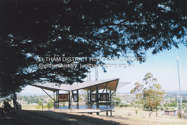
Photograph, Fay Bridge, Moor-rul Viewing Platform, Garden Hill, Kangaroo Ground, n.d
... Council. This project has been guided by an Advisory Committee with volunteer community representatives from the local Historical Societies, the Country Fire Authority, the Returned Services League and the Wurundjeri people. ...Council. This project has been guided by an Advisory Committee with volunteer community representatives from the local Historical Societies, the Country Fire Authority, the Returned Services League and the Wurundjeri people. ...OPENING OF THE VIEWING PLATFORM AT KANGAROO GROUND Nillumbik Council has advised that the viewing platform at Kangaroo Ground 27km NE of Melbourne is to be opened to the public on Wednesday, March 26th 2008 (Melway 271 , G10). The function of the platform is to provide shelter adjacent to the War Memorial Tower whilst allowing all people to enjoy the stunning panoramic views. From the platform you. can see the Dandenongs, the city of Melbourne, the You Yangs, Mount Macedon, the Kinglake Ranges and the Mt Baw-Baw Ranges where the Yarra River starts. This landscape covers all the ancestral lands of the Wurundjeri and some of the wider Kulin nation land. The platform has been given the name Moor-rut, a name which described the fertile soils of the Kangaroo Ground area in contrast to the poorer (Silurian) country of its surrounds, which the Wurundjeri knew as 'Nillumbik' or less rich country. The full 360 degree view can be seen from the adjacent Tower of Remembrance which has 53 stairs. The viewing platform however can be accessed by wheelchair. Inside the viewing platform there are eight double sided interpretive panels giving the history and information regarding this special area. The viewing platform's interpretive panels set out the Aboriginal and European history of the area and also the geology and the local flora and fauna, so that the casual visitor comes away understanding more about this significant part of Victoria. The concept of the viewing platform is part of the refurbishment project for the Kangaroo Ground War Memorial Park which has taken place since 1997 with the active approval and financial assistance of the Nillumbik Shire Council. This project has been guided by an Advisory Committee with volunteer community representatives from the local Historical Societies, the Country Fire Authority, the Returned Services League and the Wurundjeri people. Other allied groups such as the Nillumbik Reconciliation Group have been called upon for their expertise. The initial idea for the viewing platform came from Dean Stewart when he was the caretaker while living at the park. He discussed this idea with local author Mick Woiwod and Harry Gilham of Eltham District Historical Society when they were planning the refurbishment of the War Memorial Park in 1996. When the committee was formalised by the Nillumbik Council in 1997, Nicholas Pelling, representing the CFA and RSL, joined the group. Dennis Ward, local architect, then volunteered to develop the concept plan for the refurbishment of the park and later drew up the plans for the viewing platform. The Kangaroo Ground War Memorial Park and its Tower of Remembrance is located on one of the highest locations in the Yarra Valley. The Tower of Remembrance is a unique war memorial constructed from local stone standing 14 metres high. It was built in the style of a Scottish watchtower reflecting the strong Scottish influence of the first European settlers of the district from the 1840s onward. The park was opened in 1921 and the Tower of Remembrance was dedicated in 1926 recognising the local people who served in the First World War. Those who served in the Second World War were recognised by plaques dedicated in 1951 and more recently those who served in Korea, Borneo, Malaya and Vietnam by plaques unveiled in 2001. Harry Gilham, Advisory Committee Convenor - Eltham District Historical Society Newsletter N0 179 March 2008fay bridge collection, garden hill, kangaroo ground, memorial park, moor-rul viewing platform -
 Greensborough Historical Society
Photograph - Digital Image, Art at WaterMarc, July 2017, 22/07/2017
... Wurundjeri's traditional lands - and today the private sale and division of these farms informs the streetscape and town plan. With soil sourced locally this work reveals some of the area’s history - the text running around the perimeter was written by former resident Val Wilson, a snippet of her recollections of growing up in the area in the 1950s. The arrows and text act like a compass to orientate this site with greater Melbourne. On display in the lobby of Banyule Council...Wurundjeri's traditional lands - and today the private sale and division of these farms informs the streetscape and town plan. With soil sourced locally this work reveals some of the area’s history - the text running around the perimeter was written by former resident Val Wilson, a snippet of her recollections of growing up in the area in the 1950s. The arrows and text act like a compass to orientate this site with greater Melbourne. On display in the lobby of Banyule Council ...Photographs of an art installation by Jessie Stanley at WaterMarc Greensborough on 22/07/2017. From Jessie Stanley's FaceBook page :Dust to Dust is complete... It's an ephemeral site-specific work about how the Melbourne suburb of Greensborough has transformed over time. This area's exceptionally fertile soil [used by] by white settlers for farms, market gardens and orchards reshaped the Wurundjeri's traditional lands - and today the private sale and division of these farms informs the streetscape and town plan. With soil sourced locally this work reveals some of the area’s history - the text running around the perimeter was written by former resident Val Wilson, a snippet of her recollections of growing up in the area in the 1950s. The arrows and text act like a compass to orientate this site with greater Melbourne. On display in the lobby of Banyule Council until chance, time (or a broom) sweeps it away, Many thanks to Banyule City Council, Greensborough Historical Society and Valerie Wilson. "An artistic representation of Greensborough's history.Digital photographs of art installation.jessie stanley, watermarc, greensborough historical society, banyule council -
 Greensborough Historical Society
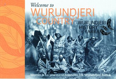
Booklet, Emily Fitzgerald et al, Welcome to Wurundjeri country: the Wurundjeri history of Yarra, 2014
... Council...Daniel Ducrou...Wurundjeri...Welcome to Wurundjeri country: the Wurundjeri history of Yarra Booklet Booklet Emily Fitzgerald Yarra City Council Daniel Ducrou Wurundjeri Tribe Land Compensation and Cultural Heritage Council Incorporated ...Brief history of the Wurundjeri-willam people of the area now known as the City of Yarra, from pre-settlement times to the present.44p., paperback, printed in black and orange, illus.wurundjeri willam, city of yarra, aborigines - victoria -
 Eltham District Historical Society Inc
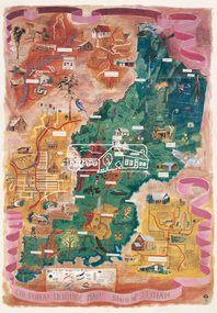
Map (item), Megan Evans, Cultural Heritage Map, Shire of Eltham, 1993
... Copy of artist's map of the Shire of Eltham with numerous historical and cultural places of interest illustrated and notated including evidence of original Wurundjeri occupation and local flora and fauna. The original watercolour is held in the Nillumbik Shire Council Civic Collection. ...Eltham District Historical Society Inc 728 Main Rd Eltham melbourne Copy of artist's map of the Shire of Eltham with numerous historical and cultural places of interest illustrated and notated including evidence of original Wurundjeri occupation and local flora and fauna. The original watercolour is held in the Nillumbik Shire Council Civic Collection. ...Copy of artist's map of the Shire of Eltham with numerous historical and cultural places of interest illustrated and notated including evidence of original Wurundjeri occupation and local flora and fauna. The original watercolour is held in the Nillumbik Shire Council Civic Collection. "Evans remembers being surprised they had asked an artist to create this map rather than a designer. Originally made as a watercolour, the map was later made into posters and adorned many homes around the area. The map creatively interprets the town and provides a wayfinding to both cultural and historical points in the area." Nillumbik Arts News December 2023. artist, buildings, cultural heritage map, fauna, flora, map, megan evans, shire of eltham, wurundjeri -
 Eltham District Historical Society Inc
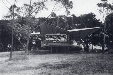
Photograph - Black and White Print, Moor-rul Viewing Platform, March 2007
... Council. This project has been guided by an Advisory Committee with volunteer community representatives from the local Historical Societies, the Country Fire Authority, the Returned Services League and the Wurundjeri people. ...Council. This project has been guided by an Advisory Committee with volunteer community representatives from the local Historical Societies, the Country Fire Authority, the Returned Services League and the Wurundjeri people. ...Early stages - no display panels installed. OPENING OF THE VIEWING PLATFORM AT KANGAROO GROUND Nillumbik Council has advised that the viewing platform at Kangaroo Ground 27km NE of Melbourne is to be opened to the public on Wednesday, March 26th 2008 (Melway 271 , G10). The function of the platform is to provide shelter adjacent to the War Memorial Tower whilst allowing all people to enjoy the stunning panoramic views. From the platform you. can see the Dandenongs, the city of Melbourne, the You Yangs, Mount Macedon, the Kinglake Ranges and the Mt Baw-Baw Ranges where the Yarra River starts. This landscape covers all the ancestral lands of the Wurundjeri and some of the wider Kulin nation land. The platform has been given the name Moor-rut, a name which described the fertile soils of the Kangaroo Ground area in contrast to the poorer (Silurian) country of its surrounds, which the Wurundjeri knew as 'Nillumbik' or less rich country. The full 360 degree view can be seen from the adjacent Tower of Remembrance which has 53 stairs. The viewing platform however can be accessed by wheelchair. Inside the viewing platform there are eight double sided interpretive panels giving the history and information regarding this special area. The viewing platform's interpretive panels set out the Aboriginal and European history of the area and also the geology and the local flora and fauna, so that the casual visitor comes away understanding more about this significant part of Victoria. The concept of the viewing platform is part of the refurbishment project for the Kangaroo Ground War Memorial Park which has taken place since 1997 with the active approval and financial assistance of the Nillumbik Shire Council. This project has been guided by an Advisory Committee with volunteer community representatives from the local Historical Societies, the Country Fire Authority, the Returned Services League and the Wurundjeri people. Other allied groups such as the Nillumbik Reconciliation Group have been called upon for their expertise. The initial idea for the viewing platform came from Dean Stewart when he was the caretaker while living at the park. He discussed this idea with local author Mick Woiwod and Harry Gilham of Eltham District Historical Society when they were planning the refurbishment of the War Memorial Park in 1996. When the committee was formalised by the Nillumbik Council in 1997, Nicholas Pelling, representing the CFA and RSL, joined the group. Dennis Ward, local architect, then volunteered to develop the concept plan for the refurbishment of the park and later drew up the plans for the viewing platform. The Kangaroo Ground War Memorial Park and its Tower of Remembrance is located on one of the highest locations in the Yarra Valley. The Tower of Remembrance is a unique war memorial constructed from local stone standing 14 metres high. It was built in the style of a Scottish watchtower reflecting the strong Scottish influence of the first European settlers of the district from the 1840s onward. The park was opened in 1921 and the Tower of Remembrance was dedicated in 1926 recognising the local people who served in the First World War. Those who served in the Second World War were recognised by plaques dedicated in 1951 and more recently those who served in Korea, Borneo, Malaya and Vietnam by plaques unveiled in 2001. Harry Gilham, Advisory Committee Convenor - Eltham District Historical Society Newsletter N0 179 March 2008 Black and white inkjet print on paper 14 x 21 cmmoor-rul viewing platform, garden hill, kangaroo ground, memorial park -
 Eltham District Historical Society Inc
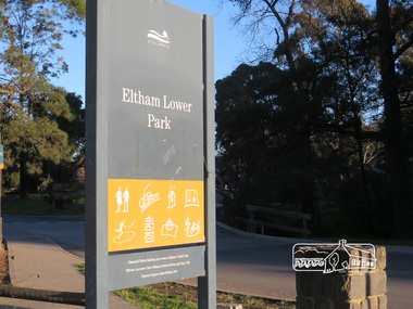
Photograph, Liz Pidgeon, Heritage Excursion; Eltham Lower Park Walk and Talk, 1 July 2017, 1 July 2017
... Council logo at the entrance of the Park. Newsletter No., 234, June 2017 Heritage Excursion - Saturday 1st July - Eltham Lower Park - Walk and Talk Eltham Lower Park has played an important part in the history of our area since the early days of European settlement when it was used by local residents as an informal racecourse. Prior to that its location at the junction of the Diamond Creek and the Yarra River made it an important meeting place for the Wurundjeri...Council logo at the entrance of the Park. Newsletter No., 234, June 2017 Heritage Excursion - Saturday 1st July - Eltham Lower Park - Walk and Talk Eltham Lower Park has played an important part in the history of our area since the early days of European settlement when it was used by local residents as an informal racecourse. Prior to that its location at the junction of the Diamond Creek and the Yarra River made it an important meeting place for the Wurundjeri ...Eltham Lower Park sign with Council logo at the entrance of the Park. Newsletter No., 234, June 2017 Heritage Excursion - Saturday 1st July - Eltham Lower Park - Walk and Talk Eltham Lower Park has played an important part in the history of our area since the early days of European settlement when it was used by local residents as an informal racecourse. Prior to that its location at the junction of the Diamond Creek and the Yarra River made it an important meeting place for the Wurundjeri people. The park combines formal elements and sporting facilities with remnant bushland that is of environmental significance. It is home to sporting and horse riding clubs, popular play spaces and the Diamond Valley Miniature Railway, which attracts large numbers of visitors. The park will be the venue for our July excursion which will comprise a walk of about 3.5 km around the park and adjacent areas. Along the way we will discuss the history and natural history of the area. The path along the creek and the river provides a pleasant and scenic walk. This walk on Saturday 1st July is about 3.5 km in length and will take 2 to 2.5 hours. It will start at 2pm at the Main Road car park at the front of the park. (Melway ref 21 H 10). Born Digitalelection day, heritage excursion, activities, eltham district historical society, eltham lower park, sign -
 Eltham District Historical Society Inc
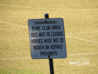
Photograph, Liz Pidgeon, Heritage Excursion; Eltham Lower Park Walk and Talk, 1 July 2017, 1 July 2017
... Sign: Nillumbik Shire Council Pony Club area dogs must be leashed horses must not be ridden on asphalt pathways Newsletter No., 234, June 2017 Heritage Excursion - Saturday 1st July - Eltham Lower Park - Walk and Talk Eltham Lower Park has played an important part in the history of our area since the early days of European settlement when it was used by local residents as an informal racecourse. Prior to that its location at the junction of the Diamond Creek and the Yarra River made it an important meeting place for the Wurundjeri...Eltham District Historical Society Inc 728 Main Rd Eltham melbourne Sign: Nillumbik Shire Council Pony Club area dogs must be leashed horses must not be ridden on asphalt pathways Newsletter No., 234, June 2017 Heritage Excursion - Saturday 1st July - Eltham Lower Park - Walk and Talk Eltham Lower Park has played an important part in the history of our area since the early days of European settlement when it was used by local residents as an informal racecourse. Prior to that its location at the junction of the Diamond Creek and the Yarra River made it an important meeting place for the Wurundjeri ...Sign: Nillumbik Shire Council Pony Club area dogs must be leashed horses must not be ridden on asphalt pathways Newsletter No., 234, June 2017 Heritage Excursion - Saturday 1st July - Eltham Lower Park - Walk and Talk Eltham Lower Park has played an important part in the history of our area since the early days of European settlement when it was used by local residents as an informal racecourse. Prior to that its location at the junction of the Diamond Creek and the Yarra River made it an important meeting place for the Wurundjeri people. The park combines formal elements and sporting facilities with remnant bushland that is of environmental significance. It is home to sporting and horse riding clubs, popular play spaces and the Diamond Valley Miniature Railway, which attracts large numbers of visitors. The park will be the venue for our July excursion which will comprise a walk of about 3.5 km around the park and adjacent areas. Along the way we will discuss the history and natural history of the area. The path along the creek and the river provides a pleasant and scenic walk. This walk on Saturday 1st July is about 3.5 km in length and will take 2 to 2.5 hours. It will start at 2pm at the Main Road car park at the front of the park. (Melway ref 21 H 10). Born Digitalelection day, heritage excursion, activities, eltham district historical society, eltham lower park, sign, eltham pony club -
 Eltham District Historical Society Inc
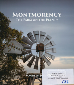
Book, Montmorency: The Farm on the Plenty by Maureen Jones, 2015
... Wurundjeri willam people, through its uptake by white settlers. Ownership of the land remained in the hands of one family for four generations spanning seventy years, before the land evolved through small farmlets into a suburb once part of the former Shire of Eltham, now part of Banyule City Council....Wurundjeri willam people, through its uptake by white settlers. Ownership of the land remained in the hands of one family for four generations spanning seventy years, before the land evolved through small farmlets into a suburb once part of the former Shire of Eltham, now part of Banyule City Council. ...This book lays out the history of Montmorency from its earliest years as a hunting ground the Wurundjeri willam people, through its uptake by white settlers. Ownership of the land remained in the hands of one family for four generations spanning seventy years, before the land evolved through small farmlets into a suburb once part of the former Shire of Eltham, now part of Banyule City Council.Little has been written on the history of this hidden suburb of Melbourne. This book is significant in that it is the first major local history publication devoted to the suburb gathered particularly from local historical society archives and oral histories. ISBN 9780980807912montmorency -
 Eltham District Historical Society Inc
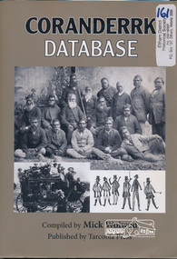
Book, Tarcoola Press, Coranderrk Database compiled by Mick Woiwod, 2012
... Wurundjeri Aboriginal Land Compensation and Cultural Heritage Council...Coranderrk Database compiled by Mick Woiwod Book Tarcoola Press Mick Woiwod Nillumbik Reconciliation Group Andrew Ross Museum Wurundjeri Aboriginal Land Compensation and Cultural Heritage Council ...Chronological timeline detailing activites at Coranderrk aboriginal station between 1867 and 1924. Accompanying CD rom at the back of the book. Sister publication to "Birrarung database." Winner of the Local History Project Award (for activities that enhance access to records of significance to local communities) as part of the Victorian Community History Awards 2012 242 pages : illustrations ; 30 cm + 1 CD-ROM (4 3/4 in.) PDF, Word files.ISBN 9780987157416coranderrk aboriginal station., australian aborginies, wurundjeri woi wurrung -
 Eltham District Historical Society Inc
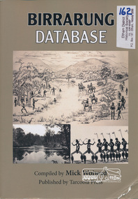
Book, Tarcoola Press, Birrarung Database compiled by Mick Woiwod, 2012
... Wurundjeri Aboriginal Land Compensation and Cultural Heritage Council...Birrarung Database compiled by Mick Woiwod Book Tarcoola Press Mick Woiwod Wurundjeri Aboriginal Land Compensation and Cultural Heritage Council Andrew Ross Museum Nillumbik Reconciliation Group ...A compilation of Woiwod's research material, with information on the history of the Wurundjeri people of the Yarra Valley, from the time of first European contact. Its prime focus is the Yarra River as it has been understood by its Wurundjeri people. Includes a compilation of those difficult to locate "brief snatches of the action" collated under headings with in each instance, the provenance as to source and / or author included. Themes include: agriculture, law, ceremony, language, reconciliation, retribution, lifestyle, art & craft, climate, personalities, disease, death and the river's flora and fauna. Sister publication to "Coranderrk database". 318 pages : illustrations, maps ; 30 cm + 1 CD-ROM (4 3/4 in.) PDF or Microsoft Office Word 97-2003.ISBN 9780987157423wurundjeri, yarra river, indigenous history, wurundjeri woi wurrung, aboriginal australians -
 Yarra City Council
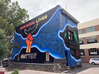
Artwork, other - Mural, Ky-ya Nicholson-Ward, Aboriginal Lives Matter, 2021
... A number of actions were generated from this decision; one of which was for Council to commission a large-scale mural that aligned with the movement. Emerging artist Ky-ya Nicholson-Ward, a proud Wurundjeri, Dja Dja Wurrung, Nguarai Illam-Wurrung, German and Irish woman, created the mural installed on a building in Peel Street Park, Collingwood. ...A number of actions were generated from this decision; one of which was for Council to commission a large-scale mural that aligned with the movement. Emerging artist Ky-ya Nicholson-Ward, a proud Wurundjeri, Dja Dja Wurrung, Nguarai Illam-Wurrung, German and Irish woman, created the mural installed on a building in Peel Street Park, Collingwood. ..."The fist references the Black Lives Matter movement and also represents the strength of Indigenous peoples all over the world and symbolises solidarity and justice for everyone affected by systematic racism. Bunjil (wedge-tailed eagle) is flying high on the building. He is the creator spirit for Wurundjeri people who looks over us and protects us. Bunjil represents healing and power to our people. The blue circles and lines represent revival and waterways; in particular, they depict the Birrarung (Yarra River), which is very significant for the Wurundjeri people. Our people are known as the Manna Gum people. The leaves in the artwork highlight Wurundjeri people and their Country. These leaves also represent the cleansing of negative spirits. The Manna Gum leaf is also an important symbolic offering in our traditional Welcome to Country ceremony. Leaves are offered to visitors as they are granted safe passage through our land. They are made welcome to everything from the tops of the trees to the roots of the earth. We ask that they take care of the land, plants and animals and to respect the protocols and rules of the Traditional Owners whilst on our Country."In 2020 Council declared its support for the global Black Lives Matter (BLM) movement. In consultation with Yarra City Council's Yana Ngargna advisory group a motion was prepared and passed unanimously by all Councillors. A number of actions were generated from this decision; one of which was for Council to commission a large-scale mural that aligned with the movement. Emerging artist Ky-ya Nicholson-Ward, a proud Wurundjeri, Dja Dja Wurrung, Nguarai Illam-Wurrung, German and Irish woman, created the mural installed on a building in Peel Street Park, Collingwood. Selected by Council's Yana Ngargna, Black Lives Matter Working Group the artwork identifies the cultural importance of the local area to the Wurundjeri Woi Wurrung people as the Traditional Owners. With a strong focus on Aboriginal identity the mural outlines the local context of the Black Lives Matter movement, which is connected to racism, policing of Aboriginal and Torres Strait Islander peoples and associated deaths in custody. The artwork acknowledges the ongoing challenges faced by Aboriginal community members and their struggle to survive white systems, policies and institutions. Ky-ya's mural tells the story of Aboriginal resilience, strength and self-determination; and will support the process of healing. It is a celebration of the local Aboriginal and Torres Strait Islander community; the significant Aboriginal history of Fitzroy, Collingwood and surrounds; and community's continuing cultural connection to the area. Importantly, this artwork provides a platform to educate a broader audience about the local context of the Black Lives Matter movement and Aboriginal deaths in custody. The mural will activate this site, enliven the area, promote inclusion, incite conversation and contribute to the creative capital of this locale. A welcoming environment for Aboriginal and non-Aboriginal communities.Aboriginal Lives Matter Ky-ya Nicholson WardOn a black background a hand fist (strength, solidarity and justice) is placed at the centre of the building; Bunjil (wedge-tailed eagle) is depicted flying high on the building; blue circles and lines represent revival and waterways (Birrarung-Yarra River) and the leaves in the artwork highlight Wurundjeri people (cleansing of spirit and welcome to Country)The artist name 'Ky-ya Nicholson Ward' painted in white, low right of the wall facing into Peel Street Park. black lives matter (blm) movement, wurundjeri woi wurrung, bunjil, identity, birrarung, country -
 Yarra City Council
Artwork, other - Mural, Fiona McMonagle, The Park, 2022
... Wurundjeri Woi Wurrung people, the Traditional Owners of the land now known as Yarra. Installed on the Jack Dyer Pavilion at Citizens Park in 2022, 'The Park' celebrates inclusivity and the contemporary sporting activities that this space represents today for the City of Yarra. This commission is a result of Council’s ...'The first panel celebrates the long history of runners that use the park. Richmond Harriers Athletics Club was established in 1913 and is the oldest athletics club in Victoria. The central panel depicts young female footballers and recognises female athletes and the popularity of women and girls' teams in contemporary sports. The final panel depicts a children’s cricket match. The young players are represented through the depiction of a game that is part of our national psyche and firmly entrenched in Australian culture.'Inner-city parks like Citizens Park have many diverse uses. They provide places to play, to exercise and to relax. They are spaces for community and are often subject to competing values and interests. The re-development of the Jack Dyer Pavilion at Citizens Park allows for the growth of the local community’s diverse interests and values and enables participation and interaction. 'The Park' focuses on the recreational uses of Citizens Park and its role as a community space in an area that is changing rapidly. The mural consists of three panels that address inclusivity and access to sport. Three core sporting groups who each utilize the pavilion and park as a public recreational space are represented: children, sport teams and runners. In fostering the representation of these groups, the panels also attest to the past, present, and future of this important space.Three sporting groups are represented: athletics/runners, women footballers in line formation and young cricketers in action/play. Accompanying plaquesport, women, community, richmond, parks -
 Ringwood and District Historical Society
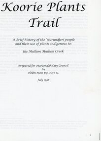
Book, Koori Plants Trail, 1998
... Brief History of the Wurundjeri people and the use of plants indigenous to the Mullum Mullum Creek prepared for Maroondah City Council - July 1998...Ringwood and District Historical Society 125A Warrandyte Road Ringwood North melbourne Brief History of the Wurundjeri people and the use of plants indigenous to the Mullum Mullum Creek prepared for Maroondah City Council - July 1998 Koori Plants Trail Book Helen Moss Helen Moss ...Brief History of the Wurundjeri people and the use of plants indigenous to the Mullum Mullum Creek prepared for Maroondah City Council - July 1998 -
 Greensborough Historical Society
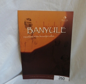
Booklet, Banyule City Council, Banyule: Heartland of the Wurundjeri willam, 2011_
... Wurundjeri willam clan, including William Barak. Illustrations are from La Trobe Picture Collection, State Library of Victoria. Booklet prepared for Banyule City Council...Wurundjeri willam clan, including William Barak. Illustrations are from La Trobe Picture Collection, State Library of Victoria. Booklet prepared for Banyule City Council ...This booklet "looks into Banyule's Aboriginal heritage" by detailing some of the history of the Wurundjeri willam clan, including William Barak. Illustrations are from La Trobe Picture Collection, State Library of Victoria. Booklet prepared for Banyule City Council by Phillippa Sutherland.6 pages, colour illustrations. Cover is mainly orange with line drawings courtesy of the Rare Book collection State Library of Victoria. 2 copiesbanyule, wurundjeriwillam, william barak, phillippa sutherland -
 Greensborough Historical Society
Booklet, Banyule City Council, Banyule: looking into Banyule's aboriginal heritage, 2014_
... wurundjeri willam william barak billi-billeri 8 pages, colour illustrations. Cover is mainly orange with pencil drawing of indigenous people. Banyule: looking into Banyule's aboriginal heritage. Booklet Banyule City Council ...This booklet "looks into Banyule's Aboriginal heritage" by detailing some of the history of the Wurundjeri willam clan, including William Barak. Illustrations are from La Trobe Picture Collection, State Library of Victoria. It appears to be a later edition of the 2011 booklet.8 pages, colour illustrations. Cover is mainly orange with pencil drawing of indigenous people.banyule, wurundjeri willam, william barak, billi-billeri -
 Federation University Historical Collection
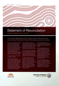
Poster, Univerrsity of Ballarat Statement of Reconciliation, 2012
... Barker Library (top floor) Mount Helen goldfields poster university of ballarat reconciliation aboriginal torres straight islander statement of reconciliation wotjobaluk wergaia japagalk jadawadjali jaadwa wadawurrung dja dja wurrung djabwurrung wurundjeri reconciliation australia poster university of ballarat reconciliation aboriginal torres straight islander statement of reconciliation wotjobaluk wergaia japagalk jadawadjali jaadwa wadawurrung dja dja wurrung djabwurrung wurundjeri reconciliation australia printed "Statement of Reconciliation University of Ballarat Council July 2012...." printed poster Univerrsity of Ballarat Statement of Reconciliation Poster Poster ...printed posterprinted "Statement of Reconciliation University of Ballarat Council July 2012...."poster, university of ballarat, reconciliation, aboriginal, torres straight islander, statement of reconciliation, wotjobaluk, wergaia, japagalk, jadawadjali, jaadwa, wadawurrung, dja dja wurrung, djabwurrung, wurundjeri, reconciliation australia, poster, university of ballarat, reconciliation, aboriginal, torres straight islander, statement of reconciliation, wotjobaluk, wergaia, japagalk, jadawadjali, jaadwa, wadawurrung, dja dja wurrung, djabwurrung, wurundjeri, reconciliation australia -
 Sunshine and District Historical Society Incorporated
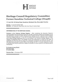
Document - Heritage Council Of Victoria Former Sunshine Technical College Determination 2025, Heritage Victoria, 20th January 2025
... Heritage Council Victoria Heritage Council Regulatory Committee Former Sunshine Technical College (H2458) 111 and 129–133 Derby Road, Sunshine, Brimbank City, Wurundjeri Country Hearing – 21 and 22 October 2024 Members – Dr Ursula de Jong (Chair), Ms Anna Foley, Dr Janine Major...Sunshine Technical School Sunshine Technical College Sunshine Secondary College Heritage Council Victoria Heritage Council Regulatory Committee Former Sunshine Technical College (H2458) 111 and 129–133 Derby Road, Sunshine, Brimbank City, Wurundjeri Country Hearing – 21 and 22 October 2024 Members – Dr Ursula de Jong (Chair), Ms Anna Foley, Dr Janine Major Digital PDF File Document Heritage Council Of Victoria Former Sunshine Technical College Determination 2025 Heritage Victoria ...On 15 January 2024, the Executive Director made a recommendation (‘the Recommendation’) to the Heritage Council, pursuant to Part 3, Division 3 of the Heritage Act 2017 (‘the Act’), that the Former Sunshine Technical College, at 111 and 129–133 Derby Road, Sunshine (‘the Place’), is not of State-level cultural heritage significance and should not be included in the Victorian Heritage Register (‘the Heritage Register’), pursuant to section 49(1)(b) of the Act. An appeal was made by seven submissions. • Albion and Ardeer Community Club (Neil Head), who did not support the Recommendation and requested that a hearing be held • Sunshine and Districts Historical Society (John Pardy), who did not support the Recommendation and wished to participate in any hearing • Sunshine and Districts Historical Society (Olwen Ford), who did not support the Recommendation and requested that a hearing be held • Harwood Andrews Lawyers, on behalf of the Brimbank City Council, who did not support the Recommendation and requested that a hearing be held • Royal Historical Society of Victoria, who did not support the Recommendation and wished to participate in any hearing • Lesley Preston, who did not support the Recommendation and wished to participate in any hearing. After considering the Executive Director’s recommendation and all submissions received, and after conducting a hearing, the Heritage Council has determined, pursuant to section 49(1)(a) of the Heritage Act 2017, that the Former Sunshine Technical College located at 111 and 129–133 Derby Road, Sunshine, Brimbank City is of State-level cultural heritage significance and is to be included in the Victorian Heritage Register in the category of Registered Place. The Heritage Council has determined to include as the extent of registration the area that was the subject of a nomination accepted by the Executive Director, and has determined, pursuant to section 49(3) of the Heritage Act 2017, to include categories of works or activities which may be carried out in relation to the place, for which a permit is not required (permit exemptions).The significance of this successful appeal was a major win for local heritage advocates (including the Sunshine & District Historical Society, RHSV, and Brimbank Council), who argued that the school’s story is inseparable from Sunshine’s identity. As the site had been under threat, with earlier proposals to demolish the buildings, this determination now gives the site strong legal protection. Developers and government agencies must now work within the heritage permit system, ensuring conservation of key buildings.Heritage Council Victoria Heritage Council Regulatory Committee Former Sunshine Technical College (H2458) 111 and 129–133 Derby Road, Sunshine, Brimbank City, Wurundjeri Country Hearing – 21 and 22 October 2024 Members – Dr Ursula de Jong (Chair), Ms Anna Foley, Dr Janine Majorsunshine technical school, sunshine technical college, sunshine secondary college -
 Whitehorse Historical Society Inc.
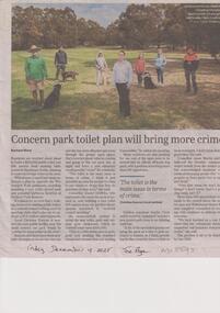
Article, Ward, Rachael, Park Toilet Plan, 19/12/2025
... Whitehorse Council endorsed a plan to upgrade the Wurundjeri Walk parklands including installing a new toilet, gravel path and potential barbecue facilities at Orchard Park Reserve....Whitehorse Council endorsed a plan to upgrade the Wurundjeri Walk parklands including installing a new toilet, gravel path and potential barbecue facilities at Orchard Park Reserve. ...Residents are worried about plans to build a $150,000 public toilet just 200 metres from existing bathrooms in Blackburn South, claiming it could encourage crime.non-fictionResidents are worried about plans to build a $150,000 public toilet just 200 metres from existing bathrooms in Blackburn South, claiming it could encourage crime.city og whitehorse, toilet block, blackburn south, crime, wurundjeri walk, ward rachael -
 Sunshine and District Historical Society Incorporated
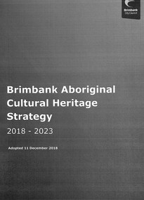
Document - Brimbank City Council Adopted Aboriginal Cultural Heritage Strategy 2018 - 2023, City of Brimbank, 2018
... This Strategy has been informed by consultation with the Wurundjeri Tribe Land and Compensation Cultural Heritage Council, Boon Wurrung Foundation / Yaluk-ut Weelam Elders council and the Bunurong Land Council Aboriginal Corporation....This Strategy has been informed by consultation with the Wurundjeri Tribe Land and Compensation Cultural Heritage Council, Boon Wurrung Foundation / Yaluk-ut Weelam Elders council and the Bunurong Land Council Aboriginal Corporation. ...This Strategy has been informed by consultation with the Wurundjeri Tribe Land and Compensation Cultural Heritage Council, Boon Wurrung Foundation / Yaluk-ut Weelam Elders council and the Bunurong Land Council Aboriginal Corporation.The City of Brimbank has within its boundaries some Aboriginal sites that are a significant part of the heritage of all Australians and are a fundamental part of Victorian Aboriginal community life and cultural identity.Brimbank City Council Adopted Aboriginal Cultural Heritage Strategy 2018 - 2023 Adopted 11 December 2018first nation, aboriginal -
 Nillumbik Shire Council
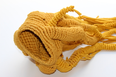
Sculpture (textile): Susan WIRTH (b.1967 Syd AUS), I want to love this country (Murnong), 2017
... Council melbourne Nillumbik Prize finalist (2018, 2016, 2015, 2014). The artist lives and works in Nillumbik. Abstract sculpture inspired by the artist attending a local ceremony in Nillumbik to harvest tubers of the Murnong (yam daisy), a traditional staple of the Wurundjeri people. ...Nillumbik Prize finalist (2018, 2016, 2015, 2014). The artist lives and works in Nillumbik. Abstract sculpture inspired by the artist attending a local ceremony in Nillumbik to harvest tubers of the Murnong (yam daisy), a traditional staple of the Wurundjeri people. Wirth was also inspired by the writing of Bruce Pascoe. Wirth works intuitively with awareness that meaning may be deciphered through the combination of material/mediums/techniques that she uses randomly. Through the process of experimentation and automatism Wirth allows her work to evolve organically. Wirth is represented in public art collections including: Victorian College of the Arts, Victorian Performing Arts Centre and Ararat Regional Gallery. She also completed a residency at Laughing Waters in 2012. Yellow abstract sculpture woven into a vessel with long tentacles using cotton yarn. N/Afinalist, nillumbik prize, abstract, textile, yellow, vessel, yam