Showing 9 items matching "yallambie road watsonia"
-
 Greensborough Historical Society
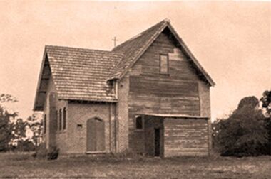
Photograph - Digital Image, Chapel corner Yallambie Road and Greensborough Highway 1950s, 1950s
... yallambie road watsonia...Greensborough Historical Society 34A Glenauburn Road Lower Plenty Lower Plenty melbourne Black and white photograph of an old chapel that stood on the corner of Yallambie Road and Greensborough Highway in the 1950s This chapel has been demolished. yallambie road watsonia greensborough road watsonia Digital copy of black and white photograph Chapel corner Yallambie Road and Greensborough Highway 1950s Photograph - Digital Image ...Black and white photograph of an old chapel that stood on the corner of Yallambie Road and Greensborough Highway in the 1950sThis chapel has been demolished.Digital copy of black and white photographyallambie road watsonia, greensborough road watsonia -
 Greensborough Historical Society
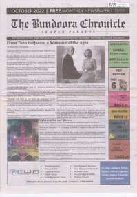
Newspaper, The Chronicle Newspaper Group, The Bundoora Chronicle - Semper Paratus. Edition 01/22. October 2022, 2022_10
... Greensborough Historical Society 34A Glenauburn Road Lower Plenty Lower Plenty melbourne First published in 2022, the Bundoora Chronicle was distributed to Mill Park, Watsonia North, Greensborough, Yallambie, Watsonia, Macleod, Kingsbury. ...First published in 2022, the Bundoora Chronicle was distributed to Mill Park, Watsonia North, Greensborough, Yallambie, Watsonia, Macleod, Kingsbury. During the pandemic in 2020, most local papers ceased production. Unfortunately, although named the Bundoora Chronicle, this newspaper holds no local news and is more an advertising feature for greater Melbourne.Newspaper, 20 pages. Black text, colour and black and white images. 2 copiesnewspapers - melbourne, local newspapers -
 Greensborough Historical Society
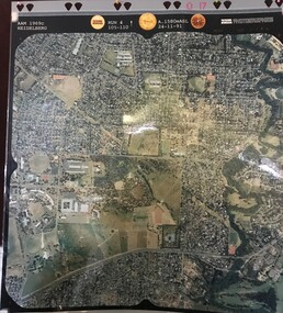
Aerial Photograph, AAM Photographics, Heidelberg AAM1969c 086, 24/11/1991
... One of a series of four overlapping aerial photographs of the Heidelberg/Greensborough areas in 1991, covering Simpson Barracks, Macleod, Rosanna, Viewbank, Watsonia & Yallambie. North boundary Yallambie Road; West boundary Hurstbridge railway....North boundary Yallambie Road; West boundary Hurstbridge railway. simpson barracks yallambie watsonia macleod rosanna viewbank Laminated colour aerial photographs Heidelberg AAM1969c 086 Aerial Photograph AAM Photographics ...One of a series of four overlapping aerial photographs of the Heidelberg/Greensborough areas in 1991, covering Simpson Barracks, Macleod, Rosanna, Viewbank, Watsonia & Yallambie. North boundary Yallambie Road; West boundary Hurstbridge railway.Laminated colour aerial photographssimpson barracks, yallambie, watsonia, macleod, rosanna, viewbank -
 Greensborough Historical Society
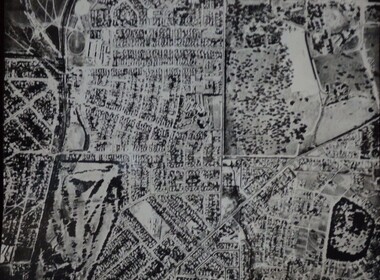
Aerial Photograph, Watsonia and Rosanna, 1945c
... Greensborough Historical Society 34A Glenauburn Road Lower Plenty Lower Plenty melbourne Covers Yallambie (Simpson Barracks) and Macleod areas yallambie macleod simpson barracks Black and white aerial photograph (copy of section) Watsonia and Rosanna Aerial Photograph ...Covers Yallambie (Simpson Barracks) and Macleod areasBlack and white aerial photograph (copy of section)yallambie, macleod, simpson barracks -
![Newspaper Clipping, School salutes principal; and, School shifts, by Fiona Kaegi. Watsonia South Primary [Wa5024], 14/12/1993](/media/collectors/4f729f5697f83e03086015b8/items/5b0f5a9521ea670234c085b5/item-media/5b39836821ea6d0008af4d63/item-fit-380x285.jpg?cb=6) Greensborough Historical Society
Greensborough Historical SocietyNewspaper Clipping, School salutes principal; and, School shifts, by Fiona Kaegi. Watsonia South Primary [Wa5024], 14/12/1993
... Greensborough Historical Society 34A Glenauburn Road Lower Plenty Lower Plenty melbourne Articles on the amalgamation of Watsonia South Primary School and Yallambie Primary School in December 1993. ...Articles on the amalgamation of Watsonia South Primary School and Yallambie Primary School in December 1993. Includes other articles from "In Watsonia with Rosalie Bray". Watsonia South Primary School operated independently from 1971 to 1993 when it amalgamated with Yallambie Primary.Newspaper clippings, black text and one photograph of principal Noel Doveywatsonia south primary school, yallambie primary school -
 Eltham District Historical Society Inc
Photograph, Fred Mitchell, Lower Plenty Road, Yallambie, 1968, 1968
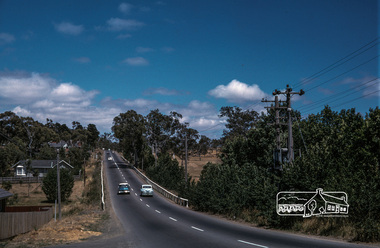
... Road...Watsonia Barracks...yallambie...Road to Rosanna beside Watsonia Army Barracks. Immediately to left is Broadlea Crescent. fred mitchell collection 1968 Broadlea crescent Lower Plenty Road Watsonia Barracks yallambie Digital copy of colour photograph Lower Plenty Road, Yallambie, 1968 Photograph Fred Mitchell ...Road to Rosanna beside Watsonia Army Barracks. Immediately to left is Broadlea Crescent.Digital copy of colour photographfred mitchell collection, 1968, broadlea crescent, lower plenty road, watsonia barracks, yallambie -
 Greensborough Historical Society
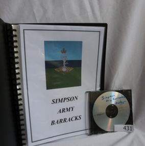
Folder and compact disc, Simpson Army Barracks, 2011_
... Road Lower Plenty Lower Plenty melbourne This document is the result of research into the history of Watsonia Barracks (now Simpson Barracks) by GHS member Marilyn Smith. It details the origin of street names in the surrounding area and includes biographical information on those after whom the streets were named. Updated December 2016. The Watsonia Barracks has been in use since WW2 and is today home to the Defence Force School of Signals. It was built on the property formerly owned by Ainslie Meares. In 1951, surrounding land was purchased for the extension of the barracks. The suburb of Yallambie ...This document is the result of research into the history of Watsonia Barracks (now Simpson Barracks) by GHS member Marilyn Smith. It details the origin of street names in the surrounding area and includes biographical information on those after whom the streets were named. Updated December 2016.The Watsonia Barracks has been in use since WW2 and is today home to the Defence Force School of Signals. It was built on the property formerly owned by Ainslie Meares. In 1951, surrounding land was purchased for the extension of the barracks. The suburb of Yallambie was formerly part of the Barracks. Black spiral bound folder (approx. 32 pages) with accompanying compact disc. Colour illustrations and maps. Updated 2016 in Word document.simpson army barracks, watsonia barracks, yallambie, marilyn smith, watsonia -
 Greensborough Historical Society
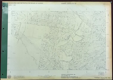
Map, Melbourne and Metropolitan Board of Works. Survey Division, MMBW, Yarra 2500 / 13.19. Lower Plenty, Montmorency, Yallambie, 1979_02
... Yallambie. Parishes of Keelbundora 2856 and Nillumbik 3310. Municipalities of Heidelberg 228, Diamond Valley 257 and Eltham 238. Prominent streets include: Elder Street, Para Road, and Main Road Lower Plenty. Includes Watsonia...Yallambie. Parishes of Keelbundora 2856 and Nillumbik 3310. Municipalities of Heidelberg 228, Diamond Valley 257 and Eltham 238. Prominent streets include: Elder Street, Para Road, and Main Road Lower Plenty. Includes Watsonia ...Melbourne and Metropolitan Board of Works. Yarra 2500 [base map] 13-19. Lower Plenty, Montmorency, Yallambie. Parishes of Keelbundora 2856 and Nillumbik 3310. Municipalities of Heidelberg 228, Diamond Valley 257 and Eltham 238. Prominent streets include: Elder Street, Para Road, and Main Road Lower Plenty. Includes Watsonia Army Barracks.MMBW Map in 1:2500 [scale] series. Cream parchment with green tape reinforcing on edges and punched holes on left edge.mmbw, melbourne and metropolitan board of works, shire of diamond valley, montmorency - maps, yallambie - maps, lower plenty - maps -
 Greensborough Historical Society
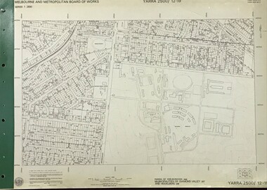
Map, Melbourne and Metropolitan Board of Works. Survey Division, MMBW, Yarra 2500 / 12.19. Watsonia, Simpson Army Barracks, 1983_03
... Watsonia Barracks (Simpson Army Barracks) and environs. Prominent streets: Yallambie Road, Greensborough Road, and Strathallan Road. ...Watsonia Barracks (Simpson Army Barracks) and environs. Prominent streets: Yallambie Road, Greensborough Road, and Strathallan Road. mmbw melbourne and metropolitan board of works shire of diamond valley watsonia - maps MMBW Map in 1:2500 [scale] series. ...Melbourne and Metropolitan Board of Works. Yarra 2500 [base map]. 12-19, Parish of Keelbundora 2856, Municipalities of Diamond Valley 257 and 228. Shows street names, easement sizes, lot numbers, lodged plan numbers, names of prominent features, contour values, creek or river names. Watsonia Barracks (Simpson Army Barracks) and environs. Prominent streets: Yallambie Road, Greensborough Road, and Strathallan Road. MMBW Map in 1:2500 [scale] series. Cream parchment with green tape reinforcing on edges and punched holes on left edge.mmbw, melbourne and metropolitan board of works, shire of diamond valley, watsonia - maps