Showing 141 items matching "yarra crossings"
-
 Port Melbourne Historical & Preservation Society
Photograph - Aerial view showing route of Lower Yarra Crossing Project (West Gate Bridge), Apr 1966
... Aerial view showing route of Lower Yarra Crossing Project (West Gate Bridge)...Black and white aerial photomap showing the proposed route of the Lower Yarra Crossing Project, later to become the West Gate Bridge and Freeway. ...'Lower Yarra Crossing Project' '296769'...April 1966 Photograph Aerial view showing route of Lower Yarra Crossing Project (West Gate Bridge) Department of Lands and Survey ...Black and white aerial photomap showing the proposed route of the Lower Yarra Crossing Project, later to become the West Gate Bridge and Freeway. April 1966'Lower Yarra Crossing Project' '296769'west gate bridge, transport - roads, engineering - bridges -
 Williamstown Historical Society Inc
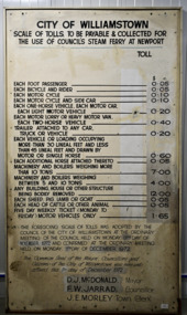
Sign - Sign - Williamstown/Port Melbourne Ferry toll sign
... ...Yarra crossings...Westgate Bridge Newport ferry Williamstown ferry Yarra crossings "CITY OF WILLIAMSTOWN/SCALE OF TOLLS TO BE PAYABLE AND COLLECTED FOR/THE USE OF COUNCIL’S STEAM FERRY AT NEWPORT" Lare white enamelled board with black print listing tolls and fares in dollars and cents for vehicles and animals for the Williamstown/Newport to Port Melbourne steam ferry. ...This board indicated the tolls and fares for the Williamstown/Newport to Port Melbourne steam ferry. The tolls were approved by the Williamstown Council in 1972. The ferry was an important link to the north side of the lower Yarra River before the Westgate bridge opened in November 1978. It closed in January 1974, after a mechanical breakdown.Lare white enamelled board with black print listing tolls and fares in dollars and cents for vehicles and animals for the Williamstown/Newport to Port Melbourne steam ferry. The tolls have been changed over time, and are overwitten with new fares."CITY OF WILLIAMSTOWN/SCALE OF TOLLS TO BE PAYABLE AND COLLECTED FOR/THE USE OF COUNCIL’S STEAM FERRY AT NEWPORT"westgate bridge, newport ferry, williamstown ferry, yarra crossings -
Port Melbourne Historical & Preservation Society
Document - Property valuation working papers, Lower Yarra Crossing Authority, George Levey, 1950 - 1974
... Property valuation working papers, Lower Yarra Crossing Authority......Lower Yarra Crossing Authority...Details are all in manilla folders. .14 - Lower Yarra Crossing Authority (LYCA)...Details are all in manilla folders. .14 - Lower Yarra Crossing Authority (LYCA) Document Property valuation working papers, Lower Yarra Crossing Authority George Levey ...Sample of working papers relating to the valuation of 29 premises in Port Melbourne. These papers were maintained by Mr George LEVEY, who was the City Valuer for PMCC from around the mid 1950s to about 1974. Details are all in manilla folders. .14 - Lower Yarra Crossing Authority (LYCA)built environment - commercial, business and traders, local government - city of port melbourne, industry, george levey, lower yarra crossing authority, west gate bridge -
Port Melbourne Historical & Preservation Society
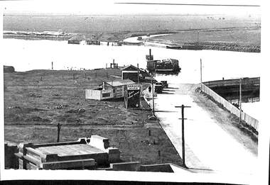
Photograph - Williamstown 'Short Road' ferry (punt) crossing the Yarra River, 1950s
... Williamstown 'Short Road' ferry (punt) crossing the Yarra River...Laser copy of photograph of the Williamstown 'Short Road' ferry (punt) crossing the Yarra River from Newport to Port Melbourne's Williamstown Road....Photograph Williamstown 'Short Road' ferry (punt) crossing the Yarra River ...copied from a photograph held by the City of Port PhillipLaser copy of photograph of the Williamstown 'Short Road' ferry (punt) crossing the Yarra River from Newport to Port Melbourne's Williamstown Road.transport - ferries -
 Port Melbourne Historical & Preservation Society
Photograph - Short Road ferry crossing Yarra from west side, 1930
... Short Road ferry crossing Yarra from west side ...Black and white photograph of Short Road ferry crossing the Yarra, taken from the west side. Roads on both sides with cars. ...Photograph Short Road ferry crossing Yarra from west side ...Black and white photograph of Short Road ferry crossing the Yarra, taken from the west side. Roads on both sides with cars. Buildings on west side.piers and wharves, short road ferry, williamstown road -
 Eltham District Historical Society Inc
Album - Photograph, J.A. McDonald, Eltham-Yarra Glen Road, 18 Oct. 1956
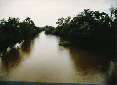
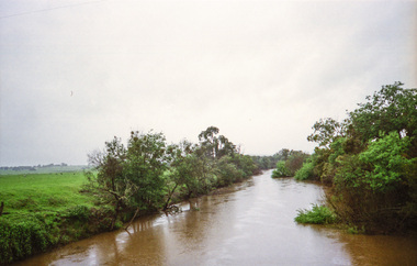
... Eltham-Yarra Glen Road Proposed crossing of Plenty River at Lower Plenty. ...Eltham District Historical Society Inc 728 Main Rd Eltham melbourne Eltham-Yarra Glen Road Proposed crossing of Plenty River at Lower Plenty. ...Eltham-Yarra Glen Road Proposed crossing of Plenty River at Lower Plenty. Floods 18th October 1956.Record of various Shire of Eltham infrastructure works undertaken during the period of 1952-1962 involving bridge and road reconstruction projects, sometimes with Eltham Shire Council Project Reference numbers quoted. It was during this period that a number of significant improvements were made to roads and new bridges constructed within the shire that remain in place as of present day (2022). In many situations, the photos provide a tangible visible record of infrastructure that existed throughout the early days of the Shire. The album was put together by or under the direction of the Shire Engineer, J.A. McDonald.infrastructure, road construction, shire of eltham, bridge construction, eltham-yarra glen road, 1956-10-18, floods, floodwater, lower plenty, plenty river -
 Mission to Seafarers Victoria
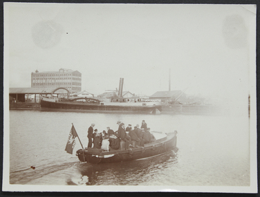
Photograph - Photograph, Sepia, circa 1910
... A group of ladies and seamen sitting on the "Southern Cross", the Mission's motor launch, leaving the Australian Wharf and crossing the Yarra River. In the background we can see the "Robur Tea House" warehouse and the south wharf....Mission to Seafarers Victoria 717 Flinders Street Docklands melbourne The motorboat Southern Cross was used for ship visits and also to Bring sailors back to the Mission or picnics. motor launch southern cross yarra river australian wharf south wharf flag lhlg robur tea house missions to seamen goldsmith album motorboat charles blunt blunt boatbuilders geelong A group of ladies and seamen sitting on the "Southern Cross", the Mission's motor launch, leaving the Australian Wharf and crossing the Yarra River. ...The motorboat Southern Cross was used for ship visits and also to Bring sailors back to the Mission or picnics.A group of ladies and seamen sitting on the "Southern Cross", the Mission's motor launch, leaving the Australian Wharf and crossing the Yarra River. In the background we can see the "Robur Tea House" warehouse and the south wharf.motor launch, southern cross, yarra river, australian wharf, south wharf, flag, lhlg, robur tea house, missions to seamen, goldsmith album, motorboat, charles blunt, blunt boatbuilders, geelong -
Port Melbourne Historical & Preservation Society
Document - Short Road Ferry ticket, c.1974
... A single trip 15 cent ticket for crossing the Yarra River from Williamstown on the Short Road Ferry. ...Yarra River to the bottom of the Strand in Williamstown. The name came from it being the 'short road' between the two places. There was a type of ferry service in operation from around 1873 which was modernised in the 20th century to take cars and trucks across the river. It was operated by two heavy chains which sank to the river bed to allow ships to pass. Transport - Ferries Short Road Ferry Williamstown Transport - Motor Vehicles A single trip 15 cent ticket for crossing ...From the collection of Warren DOUBLEDAY. The Short Road ferry ran between the end of Williamstown Road in Port Melbourne across the narrowest section of the Yarra River to the bottom of the Strand in Williamstown. The name came from it being the 'short road' between the two places. There was a type of ferry service in operation from around 1873 which was modernised in the 20th century to take cars and trucks across the river. It was operated by two heavy chains which sank to the river bed to allow ships to pass.A single trip 15 cent ticket for crossing the Yarra River from Williamstown on the Short Road Ferry. The off white ticket has two diagonal blue stripes and the number P016322 printed on the side. transport - ferries, short road ferry, williamstown, transport - motor vehicles -
Port Melbourne Historical & Preservation Society
Document - Short Road Ferry ticket 1974, 7 Jan1974
... A single trip 20 cent ticket for crossing the Yarra River from Williamstown on the Short Road Ferry. ...Yarra River to the bottom of the Strand in Williamstown. The name came from it being the 'short road' between the two places. There was a type of ferry service in operation from around 1873 which was modernised in the 20th century to take cars and trucks across the river. It was operated by two heavy chains which sank to the river bed to allow ships to pass. Transport - Ferries Short Road Ferry Williamstown Transport - Motor Vehicles On reverse side of ticket -" 8.25 pm trip. 7-1-74 (last East bound for day'" A single trip 20 cent ticket for crossing ...From the collection of Warren DOUBLEDAY. The Short Road ferry ran between the end of Williamstown Road in Port Melbourne across the narrowest section of the Yarra River to the bottom of the Strand in Williamstown. The name came from it being the 'short road' between the two places. There was a type of ferry service in operation from around 1873 which was modernised in the 20th century to take cars and trucks across the river. It was operated by two heavy chains which sank to the river bed to allow ships to pass.A single trip 20 cent ticket for crossing the Yarra River from Williamstown on the Short Road Ferry. The off white ticket has two diagonal blue stripes and the number C049655 printed on the side. On reverse side of ticket -" 8.25 pm trip. 7-1-74 (last East bound for day'"transport - ferries, short road ferry, williamstown, transport - motor vehicles -
Port Melbourne Historical & Preservation Society
Document - Short Road Ferry ticket, c.1974
... A single trip 15 cent ticket for crossing the Yarra River from Williamstown on the Short Road Ferry. ...Yarra River to the bottom of the Strand in Williamstown. The name came from it being the 'short road' between the two places. There was a type of ferry service in operation from around 1873 which was modernised in the 20th century to take cars and trucks across the river. It was operated by two heavy chains which sank to the river bed to allow ships to pass. Transport - Ferries Short Road Ferry Williamstown Transport - Motor Vehicles A single trip 15 cent ticket for crossing ...From the collection of Warren DOUBLEDAY. The short Road ferry ran between the end of Williamstown Road in Port Melbourne across the narrowest section of the Yarra River to the bottom of the Strand in Williamstown. The name came from it being the 'short road' between the two places. There was a type of ferry service in operation from around 1873 which was modernised in the 20th century to take cars and trucks across the river. It was operated by two heavy chains which sank to the river bed to allow ships to pass.A single trip 15 cent ticket for crossing the Yarra River from Williamstown on the Short Road Ferry. The off white ticket has two diagonal blue stripes and the number F 048261 printed on the side. transport - ferries, short road ferry, williamstown, transport - motor vehicles -
 Melbourne Tram Museum
Negative, Wal Jack, 10/02/1941 12:00:00 AM
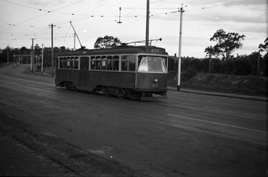
... Black and white negative, by Wal Jack, of No.Y1 611 inbound in Swan St Richmond or Burnley after crossing the Yarra River bridge. Photo dated 10-2-1941 in the Wal Jack album along with details of the location....Melbourne Tram Museum 8 Wallen Road Hawthorn melbourne Trams tramways Swan St Y1 Class Burnley tram 611 Black and white negative, by Wal Jack, of No.Y1 611 inbound in Swan St Richmond or Burnley after crossing the Yarra River bridge. Photo dated 10-2-1941 in the Wal Jack album along with details of the location. ...Black and white negative, by Wal Jack, of No.Y1 611 inbound in Swan St Richmond or Burnley after crossing the Yarra River bridge. Photo dated 10-2-1941 in the Wal Jack album along with details of the location.trams, tramways, swan st, y1 class, burnley, tram 611 -
 Melbourne Tram Museum
Negative, Wal Jack, 1/09/1941 12:00:00 AM
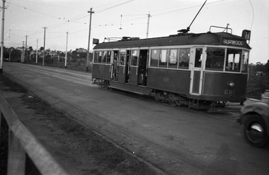
... Black and white negative, by Wal Jack, of CW5 681, (Burwood, Route 74) in Swan St Burnley, prior to crossing the Yarra River. Photo dated 1-9-1941 in the Wal Jack album along with details of the location....Melbourne Tram Museum 8 Wallen Road Hawthorn melbourne Trams tramways Burnley CW5 class Swan St Route 74 tram 681 Black and white negative, by Wal Jack, of CW5 681, (Burwood, Route 74) in Swan St Burnley, prior to crossing the Yarra River. Photo dated 1-9-1941 in the Wal Jack album along with details of the location. ...Black and white negative, by Wal Jack, of CW5 681, (Burwood, Route 74) in Swan St Burnley, prior to crossing the Yarra River. Photo dated 1-9-1941 in the Wal Jack album along with details of the location.trams, tramways, burnley, cw5 class, swan st, route 74, tram 681 -
 Kew Historical Society Inc
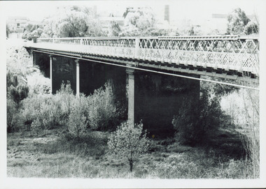
Photograph - Outer Circle Railway Viaduct
... Print copy, enlarged from original snapshot, of the former railway viaduct crossing the Yarra and linking Kew and Fairfield. ...Yarra River between East Kew and Fairfield stations. In the 1930s it was converted for vehicular traffic. In the 2010s a new concrete bridge was erected beside it to increase vehicular capacity. Railway Viaduct -- Kew (Vic.) Fairfield Bridge Fairfield Railway Viaduct Outer Circle Railway Sir John Monash CHANDLER HIGHWAY BRIDGE OVER RIVER / (ORIGINALLY PART OF OUTER CURCLE RAILWAY) / OCTOBER 1977 Print copy, enlarged from original snapshot, of the former railway viaduct crossing the Yarra and linking Kew and Fairfield. ...The heritage listed Fairfield Bridge was originally constructed for the Outer Circle Railway to bridge the Yarra River between East Kew and Fairfield stations. In the 1930s it was converted for vehicular traffic. In the 2010s a new concrete bridge was erected beside it to increase vehicular capacity.Print copy, enlarged from original snapshot, of the former railway viaduct crossing the Yarra and linking Kew and Fairfield. The original photo predates the conversion of the viaduct into the Chandler Highway Bridge in the 1930s, when the Bridge was adapted to carry vehicular traffic. The date on the reverse indicates the date of donation rather than the date on which the photograph was taken. CHANDLER HIGHWAY BRIDGE OVER RIVER / (ORIGINALLY PART OF OUTER CURCLE RAILWAY) / OCTOBER 1977railway viaduct -- kew (vic.), fairfield bridge, fairfield railway viaduct, outer circle railway, sir john monash -
 Melbourne Tram Museum
Document - Report, Graeme Breydon, "Future Development of Tramways in the Melbourne Central Business District", Apr. 1973
... Has references, looks at proposals for underground part of the Swanston St tramway, alternatives for flinders St and a Yarra crossing, St Kilda Road issues, William St, CBD problems and travel issues, shortcomings of proposals, alternatives, Flinders Gate interchanges, associated track improvements, cost benefit ratios, comments and conclusions. 2nd copy contains within a brown manila quarto sized folded marked "Tramways in the Melbourne. ...Has references, looks at proposals for underground part of the Swanston St tramway, alternatives for flinders St and a Yarra crossing, St Kilda Road issues, William St, CBD problems and travel issues, shortcomings of proposals, alternatives, Flinders Gate interchanges, associated track improvements, cost benefit ratios, comments and conclusions. 2nd copy contains within a brown manila quarto sized folded marked "Tramways in the Melbourne. ...Six paged duplicated paper or report titled "Future Development of Tramways in the Melbourne Central Business District", by Graeme Breydon, presented to the AETA 1973 Convention, based on an article prepared for the August 1972 issue of Electric Traction. Has references, looks at proposals for underground part of the Swanston St tramway, alternatives for flinders St and a Yarra crossing, St Kilda Road issues, William St, CBD problems and travel issues, shortcomings of proposals, alternatives, Flinders Gate interchanges, associated track improvements, cost benefit ratios, comments and conclusions. 2nd copy contains within a brown manila quarto sized folded marked "Tramways in the Melbourne. Central Business District" G. Breydon (Aug. 1972). See also Reg Item 3069 and 2812 for further references. .2 - letter - c Jan 1973 - carbon copy of a Letter to the Editor for response to a letter in Electric Traction Dec. 1972 responding to H. Moses and making specific comments. .3 - letter - 29/1/1973 to Graeme Breydon from the Ian Cooper of the AETA responding and accepting an offer of Graeme to present on the Board's plan for the forthcoming AETA Canberra Conference in April 1972. .4 - Report - 17 Quarto pages, stapled on the left hand side titled "Future Development of Melbourne Tramway System, with particular reference to possible improvements to the fixed plant of the Central Business District", written by Graeme Breydon, dated Jan. 1972. Refers to the 1962 report of Risson, and scheme presented to Council, Has hand drawn maps of the central area of Melbourne, Looks at the background, traffic issues, proposed underground loop, employment distribution, an extension to Elisabeth St, reversing loops, St Kilda Road and comments on the MMTB proposals. Refers to a paper delivered by D Lees, MMTB Planning Engineer, Swanston St underground proposal,on outside of the 2nd copy, and on top right hand corner of paper AETA Library mark "4E11"trams, tramways, mmtb, melbourne, traffic control, swanston st, st kilda rd, elizabeth st, bourke st, aeta, transportation, underground tramways -
 Eltham District Historical Society Inc
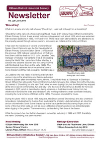
Newsletter, Newsletter, No. 228 June 2016
... Contents: • 'Shoestring' by Jim Connor • Our Next Meeting - Wednesday 8th June • Heritage Excursion - Back-track walk to Fitzsimons Lane - Saturday 2nd July • Crossing the Yarra at Eltham by Russell Yeoman • One Hundred Years Ago: Eltham and District - January-June 1916 by Liz Pidgeon • Recent Book Releases • Subscriptions • Office Bearer 2016-2017 • ... and also • Contacts for the Eltham District Historical Society ...Eltham District Historical Society Inc 728 Main Rd Eltham melbourne Contents: • 'Shoestring' by Jim Connor • Our Next Meeting - Wednesday 8th June • Heritage Excursion - Back-track walk to Fitzsimons Lane - Saturday 2nd July • Crossing the Yarra at Eltham by Russell Yeoman • One Hundred Years Ago: Eltham and District - January-June 1916 by Liz Pidgeon • Recent Book Releases • Subscriptions • Office Bearer 2016-2017 • ... and also • Contacts for the Eltham District Historical Society The Shire of Eltham Historical Society was formed in October 1967. ...Contents: • 'Shoestring' by Jim Connor • Our Next Meeting - Wednesday 8th June • Heritage Excursion - Back-track walk to Fitzsimons Lane - Saturday 2nd July • Crossing the Yarra at Eltham by Russell Yeoman • One Hundred Years Ago: Eltham and District - January-June 1916 by Liz Pidgeon • Recent Book Releases • Subscriptions • Office Bearer 2016-2017 • ... and also • Contacts for the Eltham District Historical Society The Shire of Eltham Historical Society was formed in October 1967. The first newsletter of the Society was issued May 1978 and has been published continuously ever since on a bi-monthly basis. With the cessation of the Shire of Eltham in late 1994, the Society's name was revised to Eltham District Historical Society and this name first appeared with issue No. 103, July 1995. The collection of the Society's newsletters provides a valuable resource on the history of the Society's activities, office bearers and committee members, guest speakers and subjects of historical interest pertinent to the former Shire of Eltham and the Eltham District.A4 photocopied newsletter distributed to membersnewsletter, eltham district historical society, shire of eltham historical society -
 Melbourne Tram Museum
Document - Radio Transcript, Melbourne & Metropolitan Tramways Board (MMTB), "Wireless Report -- Mr. J. D. Barton Staff Officer MMTB", late 1920's
... Looks at the history of public transport in Melbourne, in particular early transport problems, crossing the Yarra, the formation of the Melbourne Omnibus Co, the directors, early horse buses, the formation of the Melbourne Tramway and Omnibus Co and running issues with some stories. ...Looks at the history of public transport in Melbourne, in particular early transport problems, crossing the Yarra, the formation of the Melbourne Omnibus Co, the directors, early horse buses, the formation of the Melbourne Tramway and Omnibus Co and running issues with some stories. ...Radio Transcript or script, 13 foolscap typed pages, double spaced titled "Wireless Report -- Mr. J. D. Barton Staff Officer MMTB". Looks at the history of public transport in Melbourne, in particular early transport problems, crossing the Yarra, the formation of the Melbourne Omnibus Co, the directors, early horse buses, the formation of the Melbourne Tramway and Omnibus Co and running issues with some stories. Item noted dated, presumed late 1920's.trams, tramways, public transport, radio stations, horse buses, mto co, melbourne, cable trams -
 Melbourne Tram Museum
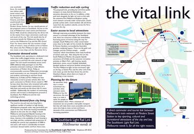
Pamphlet, Committee for the Southbank Light Rail Line, "the vital link", 1993?
... Features an image of 2001 on front cover and crossing the Yarra River....Melbourne Tram Museum 8 Wallen Road Hawthorn melbourne Trams tramways Flinders St Station Clarendon St New Tramway Batman Ave Route 96 Light Rail Yarra River tram 2001 Pamphlet - full colour A3 sheet folded to A4, titled "the vital link", outlining a proposal for a tram line connecting Flinders St station to Clarendon St, Port Junction, via the former railway bridge, connecting Batman Ave tram line. Published by the Committee for the Southbank Light Rail Line. Gives reasons and benefits for such a link. Published based on a printing date 1993. Features an image of 2001 on front cover and crossing ...Pamphlet - full colour A3 sheet folded to A4, titled "the vital link", outlining a proposal for a tram line connecting Flinders St station to Clarendon St, Port Junction, via the former railway bridge, connecting Batman Ave tram line. Published by the Committee for the Southbank Light Rail Line. Gives reasons and benefits for such a link. Published based on a printing date 1993. Features an image of 2001 on front cover and crossing the Yarra River.trams, tramways, flinders st station, clarendon st, new tramway, batman ave, route 96, light rail, yarra river, tram 2001 -
Kew Historical Society Inc
Archive (Sub-series) - Subject File, Bridges (Kew), 1958-present
... Archive file containing information relating to each of the bridges crossing the Yarra In Kew. The file includes correspondence, photocopied photographs and maps, journal articles, research, and printed ephemera. ...Archive file containing information relating to each of the bridges crossing the Yarra In Kew. The file includes correspondence, photocopied photographs and maps, journal articles, research, and printed ephemera. ...Various partiesReference, Research, InformationSecondary Values (KHS Imposed Order)Subject file containing information relating to each of the bridges crossing the Yarra In Kew. The file includes correspondence, photocopied photographs and maps, journal articles, research, and printed ephemera. Bridges referred to and described in the file include Kanes Bridge, Walmer Street Foot Bridge, Johnston Street Bridge, Chandler Bridge, Collins Bridge, Tramway or Zig Zag Bridge, Penny Toll Bridge, Victoria Street Bridge, Burke Road Bridge. The file includes original materials relating to the Victoria Street Bridge Centenary Celebration 1884-1984 -
 Eltham District Historical Society Inc
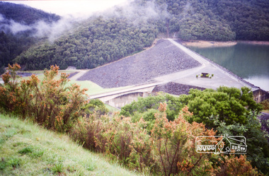
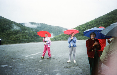
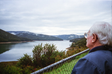
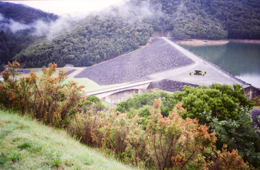
Photograph, Upper Yarra Dam, Spring Tour, 22 Oct 1995, 22/10/1995
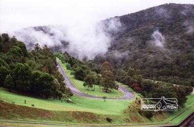
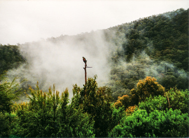
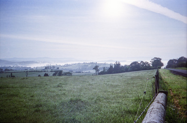
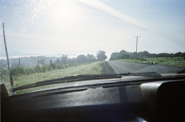
... Everard Park, named after Blanche Shallard's father, a State Member for 17 years, below the Highway Yarra crossing was in need of care. It is 10 miles from Yarra Glen by road but, as "Yarra Marra” canoeists well know, 32 winding miles down by water. ...Everard Park, named after Blanche Shallard's father, a State Member for 17 years, below the Highway Yarra crossing was in need of care. It is 10 miles from Yarra Glen by road but, as "Yarra Marra” canoeists well know, 32 winding miles down by water. ...EXPLORING THE UPPER YARRA (Newsletter No. 105, November 1995, by Bettina Woodburn) We enjoyed the Spring Excursion, this year "Exploring the Upper Yarra" - in spite of the constant rain and the countryside under the cloud cover, especially in the valleys, being mainly shiny shades of green. The occasional fields of buttercups, clumps of arum lilies and splendid rhododendron and other flowering bushes became very special. The Cobb and Co coach was warm and a cosy retreat as we zig-zagged on the highways and byways to glimpse the Yarra River, upstream and down, its secret places, and particularly the many bridges. Russell excelled as 'Poet Laureate', reading from Dacre Smyth's book. This 1979 publication includes paintings of all the bridges along the river with poems and brief descriptions of each one. Some of the bridges are in out of the way places and are not very well known. We looked forward to hearing the poetry as much as seeing the ' constructions'…Big Pat (was he short or tall, lean or fat? He did win the two hundred pound reward for discovering gold and had the creek named after him), about the 'Eddies'?, and the disliked 'meccano' bridge in Warburton, etc. etc. The hot roast lunch in the old Reefton Hotel was also most welcome. It was easy to imagine it peopled by miners and early settlers. Starting by crossing the new (1974) concrete bridge at Warrandyte we headed through Wonga Park with views to the Christmas Hills and to the escarpment of the Yering Gorge, which causes flood waters to back up through the Yarra Glen plain, so avoiding disasters downstream. At the end of a long driveway we found the wooden, privately owned Henley Bridge (1935 after the 1934 floods). This facilitates access to different parts of Henley Farm and to Lilydale. Everard Park, named after Blanche Shallard's father, a State Member for 17 years, below the Highway Yarra crossing was in need of care. It is 10 miles from Yarra Glen by road but, as "Yarra Marra” canoeists well know, 32 winding miles down by water. After more delightful countryside scenes we joined the Warburton Highway at Woori Yallock. From the old Railway Station at Launching Place the Centennial Trail for walkers, cyclists and ' horse riders has replaced the rails. The line from Lilydale was opened in 1901, and the last diesel freight train ran to Warburton in 1965. It continued to rain as we had morning tea in Warburton in a shelter between footbridges. From here we continued upstream past the Bridge to O'Shannasy Lodge and Reservoir, Starvation Creek, and the Peninsular tunnel (miners dug it as at Pound Bend) which we visited (scrambling down those steps!) on our return after lunch. Our furthermost point was the Upper Yarra Dam Reserve (and vast catchment area). Finished in 1957 after ten years work and 100 years after Yan Yean, it supplies much of Melbourne's water. After crossing the 30m Launching Place Bridge to the Eltham side of the Yarra and Healesville, we saw in the distance the Yarra Glen Timber Trestle Bridge over the river flats "the longest for years in the land it was said!" Harry's dream of "better weather over the Divide" unfortunately didn't come true, but I'm sure we 36 members will retain happy memories of a day that was wet and green and filled with Bridges. Bettina Woodburn - October 1995 Record of the Society's history of activities - Spring 1995 excursionColour photographshire of eltham historical society, activities, upper yarra dam, henley bridge -
 Eltham District Historical Society Inc
Photograph, Upper Yarra Dam, Spring Tour, 22 Oct 1995, 22/10/1995
... Everard Park, named after Blanche Shallard's father, a State Member for 17 years, below the Highway Yarra crossing was in need of care. It is 10 miles from Yarra Glen by road but, as "Yarra Marra” canoeists well know, 32 winding miles down by water. ...Everard Park, named after Blanche Shallard's father, a State Member for 17 years, below the Highway Yarra crossing was in need of care. It is 10 miles from Yarra Glen by road but, as "Yarra Marra” canoeists well know, 32 winding miles down by water. ...EXPLORING THE UPPER YARRA (Newsletter No. 105, November 1995, by Bettina Woodburn) We enjoyed the Spring Excursion, this year "Exploring the Upper Yarra" - in spite of the constant rain and the countryside under the cloud cover, especially in the valleys, being mainly shiny shades of green. The occasional fields of buttercups, clumps of arum lilies and splendid rhododendron and other flowering bushes became very special. The Cobb and Co coach was warm and a cosy retreat as we zig-zagged on the highways and byways to glimpse the Yarra River, upstream and down, its secret places, and particularly the many bridges. Russell excelled as 'Poet Laureate', reading from Dacre Smyth's book. This 1979 publication includes paintings of all the bridges along the river with poems and brief descriptions of each one. Some of the bridges are in out of the way places and are not very well known. We looked forward to hearing the poetry as much as seeing the ' constructions'…Big Pat (was he short or tall, lean or fat? He did win the two hundred pound reward for discovering gold and had the creek named after him), about the 'Eddies'?, and the disliked 'meccano' bridge in Warburton, etc. etc. The hot roast lunch in the old Reefton Hotel was also most welcome. It was easy to imagine it peopled by miners and early settlers. Starting by crossing the new (1974) concrete bridge at Warrandyte we headed through Wonga Park with views to the Christmas Hills and to the escarpment of the Yering Gorge, which causes flood waters to back up through the Yarra Glen plain, so avoiding disasters downstream. At the end of a long driveway we found the wooden, privately owned Henley Bridge (1935 after the 1934 floods). This facilitates access to different parts of Henley Farm and to Lilydale. Everard Park, named after Blanche Shallard's father, a State Member for 17 years, below the Highway Yarra crossing was in need of care. It is 10 miles from Yarra Glen by road but, as "Yarra Marra” canoeists well know, 32 winding miles down by water. After more delightful countryside scenes we joined the Warburton Highway at Woori Yallock. From the old Railway Station at Launching Place the Centennial Trail for walkers, cyclists and ' horse riders has replaced the rails. The line from Lilydale was opened in 1901, and the last diesel freight train ran to Warburton in 1965. It continued to rain as we had morning tea in Warburton in a shelter between footbridges. From here we continued upstream past the Bridge to O'Shannasy Lodge and Reservoir, Starvation Creek, and the Peninsular tunnel (miners dug it as at Pound Bend) which we visited (scrambling down those steps!) on our return after lunch. Our furthermost point was the Upper Yarra Dam Reserve (and vast catchment area). Finished in 1957 after ten years work and 100 years after Yan Yean, it supplies much of Melbourne's water. After crossing the 30m Launching Place Bridge to the Eltham side of the Yarra and Healesville, we saw in the distance the Yarra Glen Timber Trestle Bridge over the river flats "the longest for years in the land it was said!" Harry's dream of "better weather over the Divide" unfortunately didn't come true, but I'm sure we 36 members will retain happy memories of a day that was wet and green and filled with Bridges. Bettina Woodburn - October 1995 Record of the Society's history of activities - Spring 1995 excursionRoll of 35mm colour negative film, 3 stripsKodak Gold 200-4shire of eltham historical society, activities, upper yarra dam, henley bridge -
 Eltham District Historical Society Inc
Photograph, Upper Yarra Dam, Spring Tour, 22 Oct 1995, 22/10/1995
... Everard Park, named after Blanche Shallard's father, a State Member for 17 years, below the Highway Yarra crossing was in need of care. It is 10 miles from Yarra Glen by road but, as "Yarra Marra” canoeists well know, 32 winding miles down by water. ...Everard Park, named after Blanche Shallard's father, a State Member for 17 years, below the Highway Yarra crossing was in need of care. It is 10 miles from Yarra Glen by road but, as "Yarra Marra” canoeists well know, 32 winding miles down by water. ...EXPLORING THE UPPER YARRA (Newsletter No. 105, November 1995, by Bettina Woodburn) We enjoyed the Spring Excursion, this year "Exploring the Upper Yarra" - in spite of the constant rain and the countryside under the cloud cover, especially in the valleys, being mainly shiny shades of green. The occasional fields of buttercups, clumps of arum lilies and splendid rhododendron and other flowering bushes became very special. The Cobb and Co coach was warm and a cosy retreat as we zig-zagged on the highways and byways to glimpse the Yarra River, upstream and down, its secret places, and particularly the many bridges. Russell excelled as 'Poet Laureate', reading from Dacre Smyth's book. This 1979 publication includes paintings of all the bridges along the river with poems and brief descriptions of each one. Some of the bridges are in out of the way places and are not very well known. We looked forward to hearing the poetry as much as seeing the ' constructions'…Big Pat (was he short or tall, lean or fat? He did win the two hundred pound reward for discovering gold and had the creek named after him), about the 'Eddies'?, and the disliked 'meccano' bridge in Warburton, etc. etc. The hot roast lunch in the old Reefton Hotel was also most welcome. It was easy to imagine it peopled by miners and early settlers. Starting by crossing the new (1974) concrete bridge at Warrandyte we headed through Wonga Park with views to the Christmas Hills and to the escarpment of the Yering Gorge, which causes flood waters to back up through the Yarra Glen plain, so avoiding disasters downstream. At the end of a long driveway we found the wooden, privately owned Henley Bridge (1935 after the 1934 floods). This facilitates access to different parts of Henley Farm and to Lilydale. Everard Park, named after Blanche Shallard's father, a State Member for 17 years, below the Highway Yarra crossing was in need of care. It is 10 miles from Yarra Glen by road but, as "Yarra Marra” canoeists well know, 32 winding miles down by water. After more delightful countryside scenes we joined the Warburton Highway at Woori Yallock. From the old Railway Station at Launching Place the Centennial Trail for walkers, cyclists and ' horse riders has replaced the rails. The line from Lilydale was opened in 1901, and the last diesel freight train ran to Warburton in 1965. It continued to rain as we had morning tea in Warburton in a shelter between footbridges. From here we continued upstream past the Bridge to O'Shannasy Lodge and Reservoir, Starvation Creek, and the Peninsular tunnel (miners dug it as at Pound Bend) which we visited (scrambling down those steps!) on our return after lunch. Our furthermost point was the Upper Yarra Dam Reserve (and vast catchment area). Finished in 1957 after ten years work and 100 years after Yan Yean, it supplies much of Melbourne's water. After crossing the 30m Launching Place Bridge to the Eltham side of the Yarra and Healesville, we saw in the distance the Yarra Glen Timber Trestle Bridge over the river flats "the longest for years in the land it was said!" Harry's dream of "better weather over the Divide" unfortunately didn't come true, but I'm sure we 36 members will retain happy memories of a day that was wet and green and filled with Bridges. Bettina Woodburn - October 1995 Record of the Society's history of activities - Spring 1995 excursionRoll of 35mm colour negative film, 2 stripsKodak Gold 100-4shire of eltham historical society, activities, upper yarra dam, henley bridge -
 Eltham District Historical Society Inc
Photograph, Upper Yarra Dam, Spring Tour, 22 Oct 1995, 22/10/1995
... Everard Park, named after Blanche Shallard's father, a State Member for 17 years, below the Highway Yarra crossing was in need of care. It is 10 miles from Yarra Glen by road but, as "Yarra Marra” canoeists well know, 32 winding miles down by water. ...Everard Park, named after Blanche Shallard's father, a State Member for 17 years, below the Highway Yarra crossing was in need of care. It is 10 miles from Yarra Glen by road but, as "Yarra Marra” canoeists well know, 32 winding miles down by water. ...EXPLORING THE UPPER YARRA (Newsletter No. 105, November 1995, by Bettina Woodburn) We enjoyed the Spring Excursion, this year "Exploring the Upper Yarra" - in spite of the constant rain and the countryside under the cloud cover, especially in the valleys, being mainly shiny shades of green. The occasional fields of buttercups, clumps of arum lilies and splendid rhododendron and other flowering bushes became very special. The Cobb and Co coach was warm and a cosy retreat as we zig-zagged on the highways and byways to glimpse the Yarra River, upstream and down, its secret places, and particularly the many bridges. Russell excelled as 'Poet Laureate', reading from Dacre Smyth's book. This 1979 publication includes paintings of all the bridges along the river with poems and brief descriptions of each one. Some of the bridges are in out of the way places and are not very well known. We looked forward to hearing the poetry as much as seeing the ' constructions'…Big Pat (was he short or tall, lean or fat? He did win the two hundred pound reward for discovering gold and had the creek named after him), about the 'Eddies'?, and the disliked 'meccano' bridge in Warburton, etc. etc. The hot roast lunch in the old Reefton Hotel was also most welcome. It was easy to imagine it peopled by miners and early settlers. Starting by crossing the new (1974) concrete bridge at Warrandyte we headed through Wonga Park with views to the Christmas Hills and to the escarpment of the Yering Gorge, which causes flood waters to back up through the Yarra Glen plain, so avoiding disasters downstream. At the end of a long driveway we found the wooden, privately owned Henley Bridge (1935 after the 1934 floods). This facilitates access to different parts of Henley Farm and to Lilydale. Everard Park, named after Blanche Shallard's father, a State Member for 17 years, below the Highway Yarra crossing was in need of care. It is 10 miles from Yarra Glen by road but, as "Yarra Marra” canoeists well know, 32 winding miles down by water. After more delightful countryside scenes we joined the Warburton Highway at Woori Yallock. From the old Railway Station at Launching Place the Centennial Trail for walkers, cyclists and ' horse riders has replaced the rails. The line from Lilydale was opened in 1901, and the last diesel freight train ran to Warburton in 1965. It continued to rain as we had morning tea in Warburton in a shelter between footbridges. From here we continued upstream past the Bridge to O'Shannasy Lodge and Reservoir, Starvation Creek, and the Peninsular tunnel (miners dug it as at Pound Bend) which we visited (scrambling down those steps!) on our return after lunch. Our furthermost point was the Upper Yarra Dam Reserve (and vast catchment area). Finished in 1957 after ten years work and 100 years after Yan Yean, it supplies much of Melbourne's water. After crossing the 30m Launching Place Bridge to the Eltham side of the Yarra and Healesville, we saw in the distance the Yarra Glen Timber Trestle Bridge over the river flats "the longest for years in the land it was said!" Harry's dream of "better weather over the Divide" unfortunately didn't come true, but I'm sure we 36 members will retain happy memories of a day that was wet and green and filled with Bridges. Bettina Woodburn - October 1995 Record of the Society's history of activities - Spring 1995 excursionRoll of 35mm colour negative film, 4 of 5 stripsKodak Gold 400-5shire of eltham historical society, activities, upper yarra dam, henley bridge -
 Eltham District Historical Society Inc
Photograph, Spring Excursion, Exploring the Upper Yarra, 22 October 1995, 22/10/1995
... Everard Park, named after Blanche Shallard's father, a State Member for 17 years, below the Highway Yarra crossing was in need of care. It is 10 miles from Yarra Glen by road but, as "Yarra Marra” canoeists well know, 32 winding miles down by water. ...Everard Park, named after Blanche Shallard's father, a State Member for 17 years, below the Highway Yarra crossing was in need of care. It is 10 miles from Yarra Glen by road but, as "Yarra Marra” canoeists well know, 32 winding miles down by water. ...[article by Bettina Woodburn in EDHS Newsletter No. 105, November 1995:] EXPLORING THE UPPER YARRA - We enjoyed the Spring Excursion, this year "Exploring the Upper Yarra" - in spite of the constant rain and the countryside under the cloud cover, especially in the valleys, being mainly shiny shades of green. The occasional fields of buttercups, clumps of arum lilies and splendid rhododendron and other flowering bushes became very special. The Cobb and Co coach was warm and a cosy retreat as we zig-zagged on the highways and byways to glimpse the Yarra River, upstream and down, its secret places, and particularly the many bridges. Russell excelled as 'Poet Laureate', reading from Dacre Smyth's book. This 1979 publication includes paintings of all the bridges along the river with poems and brief descriptions of each one. Some of the bridges are in out-of-the-way places and are not very well known. We looked forward to hearing the poetry as much as seeing the 'constructions'… Big Pat (was he short or tall, lean or fat? - he did win the £200 reward for discovering gold and had the creek named after him), about the 'Eddies'?, and the disliked 'meccano' bridge in Warburton, etc. etc. The hot roast lunch in the old Reefton Hotel was also most welcome. It was easy to imagine it peopled by miners and early settlers. Starting by crossing the new (1974) concrete bridge at Warrandyte we headed through Wonga Park with views to the Christmas Hills and to the escarpment of the Yering Gorge, which causes flood waters to back up through the Yarra Glen plain, so avoiding disasters downstream. At the end of a long driveway we found the wooden, privately owned Henley Bridge (1935 after the 1934 floods). This facilitates access to different parts of Henley Farm and to Lilydale. Everard Park, named after Blanche Shallard's father, a State Member for 17 years, below the Highway Yarra crossing was in need of care. It is 10 miles from Yarra Glen by road but, as "Yarra Marra” canoeists well know, 32 winding miles down by water. After more delightful countryside scenes we joined the Warburton Highway at Woori Yallock. From the old Railway Station at Launching Place the Centennial Trail for walkers, cyclists and horse riders has replaced the rails. The line from Lilydale was opened in 1901, and the last diesel freight train ran to Warburton in 1965. It continued to rain as we had morning tea in Warburton in a shelter between footbridges. From here we continued upstream past the Bridge to O'Shannassy Lodge and Reservoir, Starvation Creek, and the Peninsular tunnel (miners dug it as at Pound Bend) which we visited (scrambling down those steps!) on our return after lunch. Our furthermost point was the Upper Yarra Dam Reserve (and vast catchment area). Finished in 1957 after ten years' work and 100 years after Yan Yean, it supplies much of Melbourne's water. After crossing the 30m Launching Place Bridge to the Eltham side of the Yarra and Healesville, we saw in the distance the Yarra Glen Timber Trestle Bridge over the river flats "the longest for years in the land it was said!" Harry's dream of "better weather over the Divide" unfortunately didn't come true, but I'm sure we 36 members will retain happy memories of a day that was wet and green and filled with Bridges.Two colour photographsactivities, upper yarra, upper yarra dam -
 Eltham District Historical Society Inc
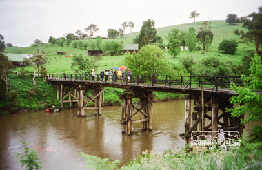
Photograph, Yarra River from Henley Bridge, Kangaroo Ground, Spring Excursion, Exploring the Upper Yarra, 22 October 1995, 22/10/1995
... Everard Park, named after Blanche Shallard's father, a State Member for 17 years, below the Highway Yarra crossing was in need of care. It is 10 miles from Yarra Glen by road but, as "Yarra Marra” canoeists well know, 32 winding miles down by water. ...Everard Park, named after Blanche Shallard's father, a State Member for 17 years, below the Highway Yarra crossing was in need of care. It is 10 miles from Yarra Glen by road but, as "Yarra Marra” canoeists well know, 32 winding miles down by water. ...[article by Bettina Woodburn in EDHS Newsletter No. 105, November 1995:] EXPLORING THE UPPER YARRA - We enjoyed the Spring Excursion, this year "Exploring the Upper Yarra" - in spite of the constant rain and the countryside under the cloud cover, especially in the valleys, being mainly shiny shades of green. The occasional fields of buttercups, clumps of arum lilies and splendid rhododendron and other flowering bushes became very special. The Cobb and Co coach was warm and a cosy retreat as we zig-zagged on the highways and byways to glimpse the Yarra River, upstream and down, its secret places, and particularly the many bridges. Russell excelled as 'Poet Laureate', reading from Dacre Smyth's book. This 1979 publication includes paintings of all the bridges along the river with poems and brief descriptions of each one. Some of the bridges are in out-of-the-way places and are not very well known. We looked forward to hearing the poetry as much as seeing the 'constructions'… Big Pat (was he short or tall, lean or fat? - he did win the £200 reward for discovering gold and had the creek named after him), about the 'Eddies'?, and the disliked 'meccano' bridge in Warburton, etc. etc. The hot roast lunch in the old Reefton Hotel was also most welcome. It was easy to imagine it peopled by miners and early settlers. Starting by crossing the new (1974) concrete bridge at Warrandyte we headed through Wonga Park with views to the Christmas Hills and to the escarpment of the Yering Gorge, which causes flood waters to back up through the Yarra Glen plain, so avoiding disasters downstream. At the end of a long driveway we found the wooden, privately owned Henley Bridge (1935 after the 1934 floods). This facilitates access to different parts of Henley Farm and to Lilydale. Everard Park, named after Blanche Shallard's father, a State Member for 17 years, below the Highway Yarra crossing was in need of care. It is 10 miles from Yarra Glen by road but, as "Yarra Marra” canoeists well know, 32 winding miles down by water. After more delightful countryside scenes we joined the Warburton Highway at Woori Yallock. From the old Railway Station at Launching Place the Centennial Trail for walkers, cyclists and horse riders has replaced the rails. The line from Lilydale was opened in 1901, and the last diesel freight train ran to Warburton in 1965. It continued to rain as we had morning tea in Warburton in a shelter between footbridges. From here we continued upstream past the Bridge to O'Shannassy Lodge and Reservoir, Starvation Creek, and the Peninsular tunnel (miners dug it as at Pound Bend) which we visited (scrambling down those steps!) on our return after lunch. Our furthermost point was the Upper Yarra Dam Reserve (and vast catchment area). Finished in 1957 after ten years' work and 100 years after Yan Yean, it supplies much of Melbourne's water. After crossing the 30m Launching Place Bridge to the Eltham side of the Yarra and Healesville, we saw in the distance the Yarra Glen Timber Trestle Bridge over the river flats "the longest for years in the land it was said!" Harry's dream of "better weather over the Divide" unfortunately didn't come true, but I'm sure we 36 members will retain happy memories of a day that was wet and green and filled with Bridges.Colour photographactivities, upper yarra, henley bridge -
 Eltham District Historical Society Inc
Photograph, Upper Yarra Dam, Spring Tour, 22 Oct 1995, 22/10/1995
... Everard Park, named after Blanche Shallard's father, a State Member for 17 years, below the Highway Yarra crossing was in need of care. It is 10 miles from Yarra Glen by road but, as "Yarra Marra” canoeists well know, 32 winding miles down by water. ...Everard Park, named after Blanche Shallard's father, a State Member for 17 years, below the Highway Yarra crossing was in need of care. It is 10 miles from Yarra Glen by road but, as "Yarra Marra” canoeists well know, 32 winding miles down by water. ...EXPLORING THE UPPER YARRA (Newsletter No. 105, November 1995, by Bettina Woodburn) We enjoyed the Spring Excursion, this year "Exploring the Upper Yarra" - in spite of the constant rain and the countryside under the cloud cover, especially in the valleys, being mainly shiny shades of green. The occasional fields of buttercups, clumps of arum lilies and splendid rhododendron and other flowering bushes became very special. The Cobb and Co coach was warm and a cosy retreat as we zig-zagged on the highways and byways to glimpse the Yarra River, upstream and down, its secret places, and particularly the many bridges. Russell excelled as 'Poet Laureate', reading from Dacre Smyth's book. This 1979 publication includes paintings of all the bridges along the river with poems and brief descriptions of each one. Some of the bridges are in out of the way places and are not very well known. We looked forward to hearing the poetry as much as seeing the ' constructions'…Big Pat (was he short or tall, lean or fat? He did win the two hundred pound reward for discovering gold and had the creek named after him), about the 'Eddies'?, and the disliked 'meccano' bridge in Warburton, etc. etc. The hot roast lunch in the old Reefton Hotel was also most welcome. It was easy to imagine it peopled by miners and early settlers. Starting by crossing the new (1974) concrete bridge at Warrandyte we headed through Wonga Park with views to the Christmas Hills and to the escarpment of the Yering Gorge, which causes flood waters to back up through the Yarra Glen plain, so avoiding disasters downstream. At the end of a long driveway we found the wooden, privately owned Henley Bridge (1935 after the 1934 floods). This facilitates access to different parts of Henley Farm and to Lilydale. Everard Park, named after Blanche Shallard's father, a State Member for 17 years, below the Highway Yarra crossing was in need of care. It is 10 miles from Yarra Glen by road but, as "Yarra Marra” canoeists well know, 32 winding miles down by water. After more delightful countryside scenes we joined the Warburton Highway at Woori Yallock. From the old Railway Station at Launching Place the Centennial Trail for walkers, cyclists and ' horse riders has replaced the rails. The line from Lilydale was opened in 1901, and the last diesel freight train ran to Warburton in 1965. It continued to rain as we had morning tea in Warburton in a shelter between footbridges. From here we continued upstream past the Bridge to O'Shannasy Lodge and Reservoir, Starvation Creek, and the Peninsular tunnel (miners dug it as at Pound Bend) which we visited (scrambling down those steps!) on our return after lunch. Our furthermost point was the Upper Yarra Dam Reserve (and vast catchment area). Finished in 1957 after ten years work and 100 years after Yan Yean, it supplies much of Melbourne's water. After crossing the 30m Launching Place Bridge to the Eltham side of the Yarra and Healesville, we saw in the distance the Yarra Glen Timber Trestle Bridge over the river flats "the longest for years in the land it was said!" Harry's dream of "better weather over the Divide" unfortunately didn't come true, but I'm sure we 36 members will retain happy memories of a day that was wet and green and filled with Bridges. Bettina Woodburn - October 1995 Record of the Society's history of activities - Spring 1995 excursionRoll of 35mm colour negative film, 3 stripsKodak Gold 200-4shire of eltham historical society, activities, upper yarra dam, henley bridge -
 Eltham District Historical Society Inc
Photograph, Upper Yarra Dam, Spring Tour, 22 Oct 1995, 22/10/1995
... Everard Park, named after Blanche Shallard's father, a State Member for 17 years, below the Highway Yarra crossing was in need of care. It is 10 miles from Yarra Glen by road but, as "Yarra Marra” canoeists well know, 32 winding miles down by water. ...Everard Park, named after Blanche Shallard's father, a State Member for 17 years, below the Highway Yarra crossing was in need of care. It is 10 miles from Yarra Glen by road but, as "Yarra Marra” canoeists well know, 32 winding miles down by water. ...EXPLORING THE UPPER YARRA (Newsletter No. 105, November 1995, by Bettina Woodburn) We enjoyed the Spring Excursion, this year "Exploring the Upper Yarra" - in spite of the constant rain and the countryside under the cloud cover, especially in the valleys, being mainly shiny shades of green. The occasional fields of buttercups, clumps of arum lilies and splendid rhododendron and other flowering bushes became very special. The Cobb and Co coach was warm and a cosy retreat as we zig-zagged on the highways and byways to glimpse the Yarra River, upstream and down, its secret places, and particularly the many bridges. Russell excelled as 'Poet Laureate', reading from Dacre Smyth's book. This 1979 publication includes paintings of all the bridges along the river with poems and brief descriptions of each one. Some of the bridges are in out of the way places and are not very well known. We looked forward to hearing the poetry as much as seeing the ' constructions'…Big Pat (was he short or tall, lean or fat? He did win the two hundred pound reward for discovering gold and had the creek named after him), about the 'Eddies'?, and the disliked 'meccano' bridge in Warburton, etc. etc. The hot roast lunch in the old Reefton Hotel was also most welcome. It was easy to imagine it peopled by miners and early settlers. Starting by crossing the new (1974) concrete bridge at Warrandyte we headed through Wonga Park with views to the Christmas Hills and to the escarpment of the Yering Gorge, which causes flood waters to back up through the Yarra Glen plain, so avoiding disasters downstream. At the end of a long driveway we found the wooden, privately owned Henley Bridge (1935 after the 1934 floods). This facilitates access to different parts of Henley Farm and to Lilydale. Everard Park, named after Blanche Shallard's father, a State Member for 17 years, below the Highway Yarra crossing was in need of care. It is 10 miles from Yarra Glen by road but, as "Yarra Marra” canoeists well know, 32 winding miles down by water. After more delightful countryside scenes we joined the Warburton Highway at Woori Yallock. From the old Railway Station at Launching Place the Centennial Trail for walkers, cyclists and ' horse riders has replaced the rails. The line from Lilydale was opened in 1901, and the last diesel freight train ran to Warburton in 1965. It continued to rain as we had morning tea in Warburton in a shelter between footbridges. From here we continued upstream past the Bridge to O'Shannasy Lodge and Reservoir, Starvation Creek, and the Peninsular tunnel (miners dug it as at Pound Bend) which we visited (scrambling down those steps!) on our return after lunch. Our furthermost point was the Upper Yarra Dam Reserve (and vast catchment area). Finished in 1957 after ten years work and 100 years after Yan Yean, it supplies much of Melbourne's water. After crossing the 30m Launching Place Bridge to the Eltham side of the Yarra and Healesville, we saw in the distance the Yarra Glen Timber Trestle Bridge over the river flats "the longest for years in the land it was said!" Harry's dream of "better weather over the Divide" unfortunately didn't come true, but I'm sure we 36 members will retain happy memories of a day that was wet and green and filled with Bridges. Bettina Woodburn - October 1995 Record of the Society's history of activities - Spring 1995 excursionRoll of 35mm colour negative film, 3 stripsKodak Gold 200-4shire of eltham historical society, activities, upper yarra dam, henley bridge