Showing 105 items matching "yarra gum"
-
 Eltham District Historical Society Inc
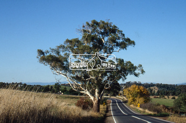
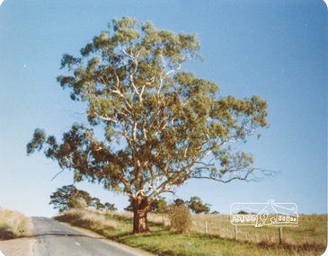
Slide - Photograph, Basalt Manna Gum, Eltham-Yarra Glen Road, Kangaroo Ground, c.1992
... Basalt Manna Gum, Eltham-Yarra Glen Road, Kangaroo Ground...Gum...Eltham-Yarra Glen Road...Eltham District Historical Society Inc 728 Main Rd Eltham melbourne Basalt Manna Gum Eltham-Yarra Glen Road Kangaroo Ground Significant tree roads infrastructure 35mm colour positive transparency Mount - Black and White Basalt Manna Gum, Eltham-Yarra Glen Road, Kangaroo Ground Slide Photograph ...35mm colour positive transparency Mount - Black and Whitebasalt manna gum, eltham-yarra glen road, kangaroo ground, significant tree, roads, infrastructure -
 Eltham District Historical Society Inc
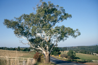
Slide - Photograph, Basalt Manna Gum, Eltham-Yarra Glen Road, Kangaroo Ground, c.1992
... Basalt Manna Gum, Eltham-Yarra Glen Road, Kangaroo Ground...gum...eltham-yarra glen road...Eltham District Historical Society Inc 728 Main Rd Eltham melbourne basalt manna gum eltham-yarra glen road kangaroo ground significant tree roads infrastructure 35mm colour positive transparency Mount - Black and White Basalt Manna Gum, Eltham-Yarra Glen Road, Kangaroo Ground Slide Photograph ...35mm colour positive transparency Mount - Black and Whitebasalt manna gum, eltham-yarra glen road, kangaroo ground, significant tree, roads, infrastructure -
 Eltham District Historical Society Inc
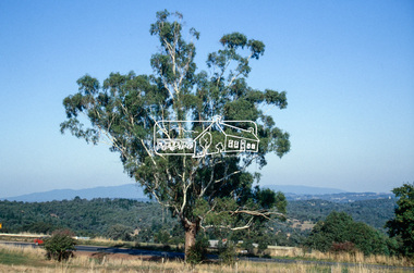
Slide - Photograph, Basalt Manna Gum, Eltham-Yarra Glen Road, Kangaroo Ground, c.1992
... Basalt Manna Gum, Eltham-Yarra Glen Road, Kangaroo Ground...gum...eltham-yarra glen road...Eltham District Historical Society Inc 728 Main Rd Eltham melbourne basalt manna gum eltham-yarra glen road kangaroo ground significant tree roads infrastructure 35mm colour positive transparency Mount - Black and White Basalt Manna Gum, Eltham-Yarra Glen Road, Kangaroo Ground Slide Photograph ...35mm colour positive transparency Mount - Black and Whitebasalt manna gum, eltham-yarra glen road, kangaroo ground, significant tree, roads, infrastructure -
 Eltham District Historical Society Inc
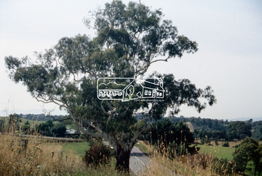
Slide - Photograph, Basalt Manna Gum, Eltham-Yarra Glen Road, Kangaroo Ground, c.Mar. 1993
... Basalt Manna Gum, Eltham-Yarra Glen Road, Kangaroo Ground...gum...eltham-yarra glen road...Eltham District Historical Society Inc 728 Main Rd Eltham melbourne significant tree basalt manna gum eltham-yarra glen road kangaroo ground Production Code "MAR M" 35mm colour positive transparency (1 of 4) Mount - Kodak Ektachrome Basalt Manna Gum, Eltham-Yarra Glen Road, Kangaroo Ground Slide Photograph ...35mm colour positive transparency (1 of 4) Mount - Kodak EktachromeProduction Code "MAR M"significant tree, basalt manna gum, eltham-yarra glen road, kangaroo ground -
 Federation University Historical Collection
Document - Plan, Mathew Gibson, Centre for Environmental Management, Ballarat Technology Park Conservation Plan, 1997, 1997
... ...yarra gum...Barker Library (top floor) Mount Helen goldfields The Ballarat Technology Park is on the Mount Helen Campus. ballarat technology park greenhill enterprise centre ibm global enterprises ballarat-buninyong railway line canadian wetlands brick railway culvert canadian creek riparian woodland yarra gum swamp gum blackwood remnant vegetation scent bark narrow-leaf peppermint messmate centre for environmental management Mount Helen Campus A4 photocopy of a plan of the Ballarat Technology Park showing features of conservation significance. ...The Ballarat Technology Park is on the Mount Helen Campus.A4 photocopy of a plan of the Ballarat Technology Park showing features of conservation significance. The plan includes the Canadian Creek, an historic hand-made brick culvert, Canadian Wetland Development, early wooden bridge, old path of the Ballarat-Buninyong Railway line, Greenhill Enterprise Centre and IBM Global Services.ballarat technology park, greenhill enterprise centre, ibm global enterprises, ballarat-buninyong railway line, canadian wetlands, brick railway culvert, canadian creek, riparian woodland, yarra gum, swamp gum, blackwood, remnant vegetation, scent bark, narrow-leaf peppermint, messmate, centre for environmental management, mount helen campus -
 Federation University Herbarium
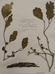
Plant specimen, Alexander Clifford Beauglehole, Eucalyptus yarraensis Maiden & Cambage, 8/11/1978
... ...Yarra Gum...Beauglehole Herbarium Herbarium specimen Botany Herbarium Plant Science Plant Specimen Field Naturalists' Club Ballarat Federation University Herbarium Eucalyptus yarraensis Yarra Gum Myrtaceae A mounted botanical specimen. ...Cliff Beauglehole was an orchardist at Portland, Victoria, who throughout hislife took an intense interest in the plants of Victoria. Over his lifetime he collected 90,000 plant specimens as part of a comprehensive study of Victoria's plants and wrote thirteen books under the heading The Distribution and Conservation of Vascular Plants in Victoria, each written to cover the 13 study areas of the Victorian and Conservation Council.A mounted botanical specimen.beauglehole herbarium, herbarium specimen, botany, herbarium, plant science, plant specimen, field naturalists' club ballarat, federation university herbarium, eucalyptus yarraensis, yarra gum, myrtaceae -
 Emerald Museum & Nobelius Heritage Park
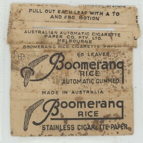
Functional object - Cigarette Paper Packet, Australian Automatic Cigarette Paper Company, 1940s
... yarra-valley-and-the-dandenong-ranges This Boomerang packet originally contained 60 leaves of pre-cut paper made from rice straw to be used for rolling cigarettes by hand or machine. It was manufactured by the Australian Automatic Cigarette Paper Company, Richmond, Victoria until 1948. Rolling one's own cigarettes was a practice of many smokers over many decades. Boomerang brand Australian Automatic Cigarette Paper Company Richmond 1948 cigarette papers '60 LEAVES / Boomerang / RICE / AUTOMATIC GUMMED ...This Boomerang packet originally contained 60 leaves of pre-cut paper made from rice straw to be used for rolling cigarettes by hand or machine. It was manufactured by the Australian Automatic Cigarette Paper Company, Richmond, Victoria until 1948.Rolling one's own cigarettes was a practice of many smokers over many decades. Boomerang Cigarette Papers packet flattened out. White but discolored. Brown Art Deco style lettering with boomerang motif. No papers.'60 LEAVES / Boomerang / RICE / AUTOMATIC GUMMED / MADE IN AUSTRALIA'boomerang brand, australian automatic cigarette paper company, richmond, 1948, cigarette papers -
 Marysville & District Historical Society
THE TRIANGLE NEWS-VOL 3 NO 13-MAY 12 1978
... Marysville & District Historical Society 39 Darwin Street Marysville yarra-valley-and-the-dandenong-ranges marysville victoria australia water-all clear community care centre brownies a hit football indoor bowls guess the weight-pumpkin golf manna gum happy birthday lost crossways restaurant & motel miss australia quest cacamboura's ladies guild golf club dinner dance marysville primary school marysville primary school mothers' club help-transport handyman fruit salad farm THE TRIANGLE NEWS-VOL 3 NO 13-MAY 12 1978 ...marysville, victoria, australia, water-all clear, community care centre, brownies a hit, football, indoor bowls, guess the weight-pumpkin, golf, manna gum, happy birthday, lost, crossways restaurant & motel, miss australia quest, cacamboura's, ladies guild, golf club dinner dance, marysville primary school, marysville primary school mothers' club, help-transport, handyman, fruit salad farm -
Marysville & District Historical Society
THE TRIANGLE NEWS-VOL 38 NO 13-APRIL 29 2011
... Marysville & District Historical Society 39 Darwin Street Marysville yarra-valley-and-the-dandenong-ranges marysville victoria australia beeches trail parks victoria meeting of the waters lush rainforest lady talbot drive phantom falls cambarville cathedral range state park community walks whitefoot dunnart dse camera survey points set up lake eildon national park gallipoli park reopens the reflective garden victorian bushfire appeal fund gallipolli park committee of management advertisements buxton silver gum secrets revealed by fires council to hold budget meeting murrindindi shire council THE TRIANGLE NEWS-VOL 38 NO 13-APRIL 29 2011 ...marysville, victoria, australia, beeches trail, parks victoria, meeting of the waters, lush rainforest, lady talbot drive, phantom falls, cambarville, cathedral range state park, community walks, whitefoot dunnart, dse, camera survey points set up, lake eildon national park, gallipoli park reopens, the reflective garden, victorian bushfire appeal fund, gallipolli park committee of management, advertisements, buxton silver gum secrets revealed by fires, council to hold budget meeting, murrindindi shire council -
Upper Yarra Museum
Wooden Serviette holder
... Upper Yarra Museum Old Railway Station 2415C Warburton Highway Yarra Junction yarra-valley-and-dandenong-ranges Used by The Mayer Chalet, Warburton. Serviette Holder Mayer Chalet Two Mountain Ash Gum trunks in fore ground with blue mountains another tree in the background. ...Used by The Mayer Chalet, Warburton.Wooden two tone, serviette Holder, hand painted on the sideTwo Mountain Ash Gum trunks in fore ground with blue mountains another tree in the background. In creme writing "From Mayer Chalet"serviette holder, mayer chalet -
Upper Yarra Museum
Serviette holder
... Upper Yarra Museum Old Railway Station 2415C Warburton Highway Yarra Junction yarra-valley-and-dandenong-ranges Used at the Mayer Chalet, Warburton. Serviette Holder Mayer Chalet Red Gum flowers with green gum leaves hanging down, creme writing "From Mayer Chalet" Wooden Serviette holder made from 2 tone wood.with hand painting on the side Serviette holder ...Used at the Mayer Chalet, Warburton.Wooden Serviette holder made from 2 tone wood.with hand painting on the sideRed Gum flowers with green gum leaves hanging down, creme writing "From Mayer Chalet"serviette holder, mayer chalet -
 Eltham District Historical Society Inc
Photograph, Fay Bridge, Ancient Eel trap on the Yarra River at Laughing Waters, Eltham - pre-dating European settlement, 6 September 2023
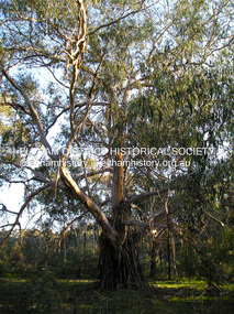
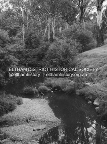
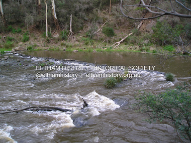
... (Eucalyptus viminalis) which is common along ‘Birrarung’ (Yarra River), and ‘djeri’, the grub which is found in or near the tree. Wurundjeri are the ‘Manna Gum People’ and their Ancestors have lived on this land for millennia. ... (Eucalyptus viminalis) which is common along ‘Birrarung’ (Yarra River), and ‘djeri’, the grub which is found in or near the tree. Wurundjeri are the ‘Manna Gum People’ and their Ancestors have lived on this land for millennia. ...Laughing Waters is the name for a stretch of the Yarra Valley Parklands consisting of river flats and hilly riparian bushland. With Birrarung (Yarra River) flowing through, Laughing Waters has been an important gathering place for thousands of years. For the Wurundjeri, ‘Garambi Baan’ (the name for Laughing Waters in Woi wurrung) is an important site for growing and harvesting food. Significantly, Wurundjeri iuk (eel) traps remain at Garambi Baan to this day. The Wurundjeri Woi Wurrung People take their name from the Woi wurrung language word ‘wurun’ meaning the Manna Gum (Eucalyptus viminalis) which is common along ‘Birrarung’ (Yarra River), and ‘djeri’, the grub which is found in or near the tree. Wurundjeri are the ‘Manna Gum People’ and their Ancestors have lived on this land for millennia. The site on the Yarra River near the former Morrison property Killeavey was given a language name in 2015 at the instigation of Wurundjeri Elder, Dave Wandin. Garambi Baan means “laughing waters” in the traditional language, Woi wurrung. The site at Warrandyte was rediscovered by Campbell Beardsell OAM in 2007 and is one of only a few known remaining iuk (eel) traps on Country once found the length of the Birrarung (Yarra) and the Maribyrnong. Original Indigenous aquacultural infrastructure was dismantled, taken away from sites and used to build houses, fords and roads by Europeans. The difficult and restricted access to this site is thought to be one of the reasons for its survival. The iuk trap is located within lands managed by Parks Victoria. The Narrap team in partnership with Parks Victoria and Acacia Land Management have been improving the native vegetation with a program of woody weed removal, exclusion fencing and revegetation. Importantly, the team have restored the trap’s infrastructure and have demonstrated its effectiveness.” References: Wurundjeri Woi Wurrung Cultural Heritage Aboriginal Corporation - Laughing Waters. (2023, September 3). Retrieved from https://inplace.org.au/laughing-waters/ GARAMBI BAAN LAUGHING WATERS RESIDENCY CENTRE 2020 2024 Strategic Plan, Nillumbik Shire Council (2023, September 3). Retrieved from https://www.nillumbik.vic.gov.au/files/assets/public/minutes-and-agendas/2020/09-sep/15-sep-cm/ocm.177-20-attachment-1-laughing-waters-arts-program_1.pdffay bridge collection, eel trap, laughing waters, yarra river, wurundjeri woi wurrung, garambi baan, 2023-09-06 -
 Eltham District Historical Society Inc
Photograph, Fay Bridge, Yellow Box Gum tree near junction of Main Yarra Trail and Mullum-Mullum Trail, Templestowe, 7 July 2019
... Yellow Box Gum tree near junction of Main Yarra Trail and Mullum-Mullum Trail, Templestowe... (Eucalyptus Melliodora) 1 image - born digital Yellow Box Gum tree near junction of Main Yarra Trail and Mullum-Mullum Trail, Templestowe Photograph Photograph Fay Bridge ...Situated in the wetlands on the trail opposite the Pontville Homestead, former home of Major Charles Newman and across the Yarra River from Sweeneys Flats, Eltham. Newman also purchased Allotment 5, Section 2 (in Ely Street, Eltham) at public autction on 17 September 1851. It was the only Section 2 allotment purchased at the firts Elthan Town Allotments public auction.fay bridge collection, sweeneys flats, 2019-07-07, major charles newman, mullum mullum creek, pontville homestead, significant tree, yellow box gum (eucalyptus melliodora) -
 Eltham District Historical Society Inc
Photograph - Digital Photograph, Alan King, Diamond Creek, Barak Bushlands, Eltham, 2008
... They form part of an important habitat corridor linking the Yarra River to the Kinglake National Park.1 Manna Gums, tawny frogmouths and platypuses are some of the indigenous plants and animals that have made their home there. ...They form part of an important habitat corridor linking the Yarra River to the Kinglake National Park.1 Manna Gums, tawny frogmouths and platypuses are some of the indigenous plants and animals that have made their home there. ...A habitat corridor and it strengthens the community. Published: Nillumbik Now and Then / Marguerite Marshall 2008; photographs Alan King with Marguerite Marshall.; p185 Barak Bushlands lie west of the Diamond Creek on the corner of Falkiner Street and busy, noisy Main Road. They form part of an important habitat corridor linking the Yarra River to the Kinglake National Park.1 Manna Gums, tawny frogmouths and platypuses are some of the indigenous plants and animals that have made their home there. The bushlands are the result of more than nine years of hard work by the local community with the Nillumbik Council, to transform a degraded flood plain into this refuge of natural beauty. In 1997, shortly after moving into the new Riverside Estate on Falkiner Street, Eltham, several residents noticed the sorry state of the Diamond Creek and surrounding area. Part of it was used as a cow paddock and although small patches of vegetation survived, the area was infested with weeds, rabbits, rubbish and drainage from the housing estate. At various times the 4.4 hectares had been used as a market garden and for shire stock piles. The residents began to restore the area by revegetating land along the Diamond Creek. In 1998 they established the Friends of the Diamond Creek Falkiner Street Reserve2 and 35 families joined from the 90-house Estate. Carolyn Mellor, as the Friends’ Land Manager, undertook a four-year horticulture course to guide this massive project for a volunteer organisation. Since 1999, she has been the Friends’ President. In 1999 the Friends urged the Nillumbik Council to undertake a feasibility study into establishing a wetland system and urban forest. Work began in 2002 with Nillumbik Council funding the project, supplemented by government grants. The Friends also received grants from Melbourne Water and Parks Victoria. Aided by the Friends and other community members, the Council created the Barak Bushlands consisting of a forest, a wetland, a bridge, a path and open space. The beautiful wetland treats most of the estate’s stormwater runoff. Storm water is filtered through plants in the wetland ponds then is released slowly into the billabong, before flowing into the Diamond Creek. The wetland also helps to minimise flooding and the improved water quality provides a flora and fauna habitat. The Friends and other volunteers planted more than 27,000 plants, more than one third of which they grew from seeds they collected at Lower Eltham and Wingrove Parks. Eltham High School students planted thousands of these through a Year Eight program introduced for this purpose. Other groups who assisted were: Green Corps, local Scouts and Guides – 2nd Montmorency, 1st Diamond Creek and 1st Eltham Cub Packs, Eltham College students, Eltham East Primary School, Landcare members, Eltham Lions Club and the Eltham Baptist Church. To maintain enthusiasm for the mammoth task, the Friends and other volunteers ‘adopted’ trees to water and wrote their names on the stakes. In 2004, to recognise the area’s original occupiers, the reserve was named Barak Bushlands. William Barak, who lived from 1824 to 1903, was the last chief of the Yarra Yarra tribe of the Wurundjeri-willam people. Traces of these original inhabitants remain in scar trees (bark sections removed to make a shield or canoe). That same year the Friends’ group was a finalist in the prestigious Federal Government, Banksia Environmental Awards. The Friends have also participated in Clean Up Australia, removing tonnes of rubbish and regularly testing the billabong, wetland and creek, for pollutants. For years the Friends, together with the Australian Platypus Conservancy, have tagged, measured and checked the health of platypuses from the Diamond and Mullum Mullum Creeks. With Latrobe University the Friends have conducted night walks to view owls, possums, bats and sugar gliders. Challenges for the council and the Friends continue with a large rabbit population, some vandalism, weed eradication and maintenance. However, thanks to this community effort, locals can now escape confined urban living on small blocks of land and enjoy the beauty of indigenous plants and animals. Working together has also strengthened the local community,This collection of almost 130 photos about places and people within the Shire of Nillumbik, an urban and rural municipality in Melbourne's north, contributes to an understanding of the history of the Shire. Published in 2008 immediately prior to the Black Saturday bushfires of February 7, 2009, it documents sites that were impacted, and in some cases destroyed by the fires. It includes photographs taken especially for the publication, creating a unique time capsule representing the Shire in the early 21st century. It remains the most recent comprehenesive publication devoted to the Shire's history connecting local residents to the past. nillumbik now and then (marshall-king) collection, barak bushlands, diamond creek (creek), eltham -
Eltham District Historical Society Inc
Document - Folder, Panton, Joseph Anderson
... Yarra River and Panton Hill is named for him. Contents Map: J A Panton's landholding with surrounding landholders. Printout and photocopy: Panton, Joseph Anderson, Australian Dictionary of Biography entry. Notes: Joseph Anderson Panton, brief biographical notes. Research Enquiry Form: Vivienne Worthington, seeking sources of information regarding Joseph Anderson Panton, 14 June 2017. Email and associated documents: Michael Kennedy seeking assistance of Eltham Gateway Action Group regarding proposed felling of manna gum...Yarra River and Panton Hill is named for him. Contents Map: J A Panton's landholding with surrounding landholders. Printout and photocopy: Panton, Joseph Anderson, Australian Dictionary of Biography entry. Notes: Joseph Anderson Panton, brief biographical notes. Research Enquiry Form: Vivienne Worthington, seeking sources of information regarding Joseph Anderson Panton, 14 June 2017. Email and associated documents: Michael Kennedy seeking assistance of Eltham Gateway Action Group regarding proposed felling of manna gum ...Joseph Anderson Panton (1831-1913) came from Scotland to Australia in 1851. In Bendigo, he was appointed assistant gold commissioner 1852 and senior commissioner 1854. Over the years, he served as magistrate at Jamieson-Wood's Point, Anderson's Creek, Heidelberg, Geelong and Melbourne. He owned land on the Yarra River and Panton Hill is named for him. Contents Map: J A Panton's landholding with surrounding landholders. Printout and photocopy: Panton, Joseph Anderson, Australian Dictionary of Biography entry. Notes: Joseph Anderson Panton, brief biographical notes. Research Enquiry Form: Vivienne Worthington, seeking sources of information regarding Joseph Anderson Panton, 14 June 2017. Email and associated documents: Michael Kennedy seeking assistance of Eltham Gateway Action Group regarding proposed felling of manna gum tree near bridge across Diamond Creek, on land once held by Joseph Anderson Panton. Newspaper article: "Historic painting might be lost to Victoria," The Age, 22 October 1985. Painting by Joseph Anderson Panton of Captain William Lonsdale's house, Victoria's first Government House, to be in forthcoming auction. Newspaper clippings, A4 photocopies, etcjoseph anderson panton, william b burnley, w walsh, r hall, r a davidson, j orford, b speers, a speers, william bell, t baillie, d mcloughlin, t prior, g e hodgkins, n rodda, w r belcher, g d boursiquot, j p imley, t b darling, h g jones, t sweny, r lane, w gordon, a e morris, d w thring, j carfrae, thomas sweeney, michael kennedy, vivienne worthington, william crozier, j frank, p carrucan, panton hill -
 Eltham District Historical Society Inc
Photograph, Fay Bridge, Ancient Eel trap on the Yarra River at Laughing Waters, Eltham - pre-dating European settlement, 16 May 2015
... (Eucalyptus viminalis) which is common along ‘Birrarung’ (Yarra River), and ‘djeri’, the grub which is found in or near the tree. Wurundjeri are the ‘Manna Gum People’ and their Ancestors have lived on this land for millennia. ... (Eucalyptus viminalis) which is common along ‘Birrarung’ (Yarra River), and ‘djeri’, the grub which is found in or near the tree. Wurundjeri are the ‘Manna Gum People’ and their Ancestors have lived on this land for millennia. ...Laughing Waters is the name for a stretch of the Yarra Valley Parklands consisting of river flats and hilly riparian bushland. With Birrarung (Yarra River) flowing through, Laughing Waters has been an important gathering place for thousands of years. For the Wurundjeri, ‘Garambi Baan’ (the name for Laughing Waters in Woi wurrung) is an important site for growing and harvesting food. Significantly, Wurundjeri iuk (eel) traps remain at Garambi Baan to this day. The Wurundjeri Woi Wurrung People take their name from the Woi wurrung language word ‘wurun’ meaning the Manna Gum (Eucalyptus viminalis) which is common along ‘Birrarung’ (Yarra River), and ‘djeri’, the grub which is found in or near the tree. Wurundjeri are the ‘Manna Gum People’ and their Ancestors have lived on this land for millennia. The site on the Yarra River near the former Morrison property Killeavey was given a language name in 2015 at the instigation of Wurundjeri Elder, Dave Wandin. Garambi Baan means “laughing waters” in the traditional language, Woi wurrung. The site at Warrandyte was rediscovered by Campbell Beardsell OAM in 2007 and is one of only a few known remaining iuk (eel) traps on Country once found the length of the Birrarung (Yarra) and the Maribyrnong. Original Indigenous aquacultural infrastructure was dismantled, taken away from sites and used to build houses, fords and roads by Europeans. The difficult and restricted access to this site is thought to be one of the reasons for its survival. The iuk trap is located within lands managed by Parks Victoria. The Narrap team in partnership with Parks Victoria and Acacia Land Management have been improving the native vegetation with a program of woody weed removal, exclusion fencing and revegetation. Importantly, the team have restored the trap’s infrastructure and have demonstrated its effectiveness.” References: Wurundjeri Woi Wurrung Cultural Heritage Aboriginal Corporation - Laughing Waters. (2023, September 3). Retrieved from https://inplace.org.au/laughing-waters/ GARAMBI BAAN LAUGHING WATERS RESIDENCY CENTRE 2020 2024 Strategic Plan, Nillumbik Shire Council (2023, September 3). Retrieved from https://www.nillumbik.vic.gov.au/files/assets/public/minutes-and-agendas/2020/09-sep/15-sep-cm/ocm.177-20-attachment-1-laughing-waters-arts-program_1.pdffay bridge collection, 2015-05-16, eel trap, laughing waters, yarra river, wurundjeri woi wurrung, garambi baan -
 Eltham District Historical Society Inc
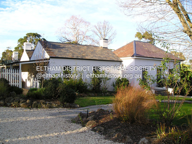
Photograph, Fay Bridge, Rosehill Homestead, EDHS Heritage Excursion, 6 July 2019
... Gums that line the route. These trees are of the spreading woodland form of this species indicating that they must have been originally growing in a reasonably open setting. The walk also includes parts of the historic Cleveland Estate and the homestead “Rosehill” established by pioneer farmer Henry Stooke. This area was the site of the first recorded European settlement in what was to become the Shire of Eltham when the Willis brothers arrived in the late 1830s. From the southern part of Cleveland Avenue there are extensive views across and along the Yarra...Gums that line the route. These trees are of the spreading woodland form of this species indicating that they must have been originally growing in a reasonably open setting. The walk also includes parts of the historic Cleveland Estate and the homestead “Rosehill” established by pioneer farmer Henry Stooke. This area was the site of the first recorded European settlement in what was to become the Shire of Eltham when the Willis brothers arrived in the late 1830s. From the southern part of Cleveland Avenue there are extensive views across and along the Yarra ...July Excursion July 6, 2019 - Exploring Lower Plenty The predominant feature of this walk in the Bonds Road area, Lower Plenty is the large number of magnificent old River Red Gums that line the route. These trees are of the spreading woodland form of this species indicating that they must have been originally growing in a reasonably open setting. The walk also includes parts of the historic Cleveland Estate and the homestead “Rosehill” established by pioneer farmer Henry Stooke. This area was the site of the first recorded European settlement in what was to become the Shire of Eltham when the Willis brothers arrived in the late 1830s. From the southern part of Cleveland Avenue there are extensive views across and along the Yarra Valley. An article on the history of this area was contained in Newsletter edition 201, November 2011. The walk will start at the at the corner of Bonds and Stawell Roads, Lower Plenty - EDHS Newsletter No. 246 June 2019fay bridge collection, 2019-07-06, blackburn bricks, eltham district historical society, heritage excursion, rosehill homestead, lower plenty -
 Eltham District Historical Society Inc
Photograph, Peter Bassett-Smith, White Gum, Main Road Eltham-Yarra Glen, Kangaroo Ground, June 1977, 1977
... White Gum, Main Road Eltham-Yarra Glen, Kangaroo Ground, June 1977...Colour photograph of a Eucalyptus Viminalis (White Gum or Ribbony Gum or Manna Gum) on Main Road, Eltham-Yarra Glen (Melways Directory Map 23 D1) looking west approximately 1 mile from Kangaroo Ground approx. opposite Andy Avard's gate....Eltham District Historical Society Inc 728 Main Rd Eltham melbourne eltham yarra glen road kangaroo ground Colour photograph of a Eucalyptus Viminalis (White Gum or Ribbony Gum or Manna Gum) on Main Road, Eltham-Yarra Glen (Melways Directory Map 23 D1) looking west approximately 1 mile from Kangaroo Ground approx. opposite Andy Avard's gate. ...Colour photograph of a Eucalyptus Viminalis (White Gum or Ribbony Gum or Manna Gum) on Main Road, Eltham-Yarra Glen (Melways Directory Map 23 D1) looking west approximately 1 mile from Kangaroo Ground approx. opposite Andy Avard's gate.eltham yarra glen road, kangaroo ground -
 Eltham District Historical Society Inc
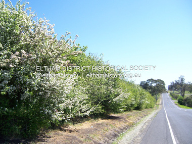
Photograph - Digital Photograph, Marguerite Marshall, Hawthorn hedges, Eltham-Yarra Glen Road, Kangaroo Ground, 3 October 2006
... Yarra Glen Road beside Wellers Restaurant, ‘dipped down into the upper reaches of Stony Creek’.4 Later some corners were compulsorily cut for the increasing motor traffic. As late as the 1960s, corners were cut to form sweeping curves above and alongside the Kangaroo Ground Cemetery and opposite the Emergency Operations Centre. In the latter case, the farmers – understanding their hedgerows as important heritage – insisted upon their reinstatement to conform to the altered road alignment. Kangaroo Ground’s ancient manna gums...Yarra Glen Road beside Wellers Restaurant, ‘dipped down into the upper reaches of Stony Creek’.4 Later some corners were compulsorily cut for the increasing motor traffic. As late as the 1960s, corners were cut to form sweeping curves above and alongside the Kangaroo Ground Cemetery and opposite the Emergency Operations Centre. In the latter case, the farmers – understanding their hedgerows as important heritage – insisted upon their reinstatement to conform to the altered road alignment. Kangaroo Ground’s ancient manna gums ...Hawthorn hedges are important reminders of Kangaroo Ground's Scottish heritage. They are Registered on the Victorian Heritage Register. They are "historically significant because the planting of hawthorn hedges reflects the adoption of Eurorpean farming techniques by the Kangaroo Ground population in the period following settlement and because the grid pattern of paddocks that the Hawthorn hedges define is very different to today's farm landscapes." Covered under Heritage Overlay, Nillumbik Planning Scheme. Published: Nillumbik Now and Then / Marguerite Marshall 2008; photographs Alan King with Marguerite Marshall.; p21 Hawthorn hedges bordering Kangaroo Ground’s gently rolling farmlands are important reminders of its Scottish heritage and are rare so close to Melbourne.1 As early as the 1840s newly arrived farmers from Scotland planted hawthorn hedges around their properties, to protect crops from the numerous kangaroos and wallabies. Many of these hedges survive today. These farmers had the good fortune to settle some of the most fertile land available for cropping in the Colony of Victoria. At that time the black volcanic soil could sustain an amazing two crops a year. By the mid 1850s, 500 acres (202ha) of wheat were growing in Kangaroo Ground. But the crops were threatened by kangaroos, which were so plentiful, that Surveyor-General, Robert Hoddle, named the district Kangaroo Ground in 1838. As post-and-rail fences proved inadequate barriers for the bounding kangaroos, the Scots planted hawthorn hedgerows as they had done in Scotland. Some also used the hedges to net birds, presumably for the table. Interestingly the farmers in the bordering townships of Panton Hill and Christmas Hills, did not plant hawthorn hedges around their properties. Perhaps it was because by the time they settled in the 1860s and 1870s most of the wildlife had been gunned down by residents.2 The canny Scots planted the hedges on public land outside their own farms, as the hedgerows could spread to about five yards (five m) in width. With this impenetrable barrier Kangaroo Ground’s industrious farmers flourished to gain the economic power that saw the Shire of Eltham governed from Kangaroo Ground for 79 years (1858-1937). The Scots jealously guarded their land, so hard to get in Scotland. That is why they refused to release any of it ‘for local roads to follow easier grades as was the case in surrounding districts where roads generally followed ridgelines or streams’.3 Instead the roads were built in accordance with the magnetic bearings of their first survey in 1847 whether that suited the steep topography or not. This could force traffic to diverge when wet through Greensborough and Diamond Creek. Until 1921, the Eltham-Yarra Glen Road beside Wellers Restaurant, ‘dipped down into the upper reaches of Stony Creek’.4 Later some corners were compulsorily cut for the increasing motor traffic. As late as the 1960s, corners were cut to form sweeping curves above and alongside the Kangaroo Ground Cemetery and opposite the Emergency Operations Centre. In the latter case, the farmers – understanding their hedgerows as important heritage – insisted upon their reinstatement to conform to the altered road alignment. Kangaroo Ground’s ancient manna gums also point to the district’s history and to that of the hedgerows. The Aboriginal people had transformed the original forests into grasslands with the fires they lit to attract kangaroos, (which the Scots were to exclude by planting hedgerows). But the Wurundjeri hunters left the gums (Eucalyptus vimminalis cygnetensis), on the grasslands as ‘stalking trees’ to hunt kangaroos. The hawthorn hedges in Kangaroo Ground were neglected for around 60 years from about the middle of the 20th century. Bushfires had created gaps and the hedgerows were not trimmed. Then in late 2005, local historian Mick Woiwod, formed a group to lobby the Nillumbik Shire to restore the hedges, which could last for many centuries. Some hedges in parts of Britain date back to AD 800.5 Although the original Scottish farmers have gone, the hedges are a reminder of when they flourished in the district, which has changed little in 150 years.This collection of almost 130 photos about places and people within the Shire of Nillumbik, an urban and rural municipality in Melbourne's north, contributes to an understanding of the history of the Shire. Published in 2008 immediately prior to the Black Saturday bushfires of February 7, 2009, it documents sites that were impacted, and in some cases destroyed by the fires. It includes photographs taken especially for the publication, creating a unique time capsule representing the Shire in the early 21st century. It remains the most recent comprehenesive publication devoted to the Shire's history connecting local residents to the past. nillumbik now and then (marshall-king) collection, eltham-yarra glen road, hawthorn hedgerow, kangaroo ground -
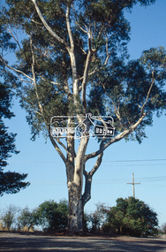
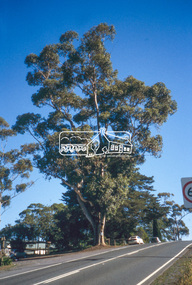
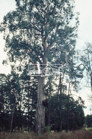 Eltham District Historical Society Inc
Slide - Photograph, Sugar Gum, 295 Eltham-Yarra Glen Road, Kangaroo Ground, c.1992
... Sugar Gum, 295 Eltham-Yarra Glen Road, Kangaroo Ground...Yarra Glen Road...Heritage tree...Kangaroo Ground...Significant tree...Sugar Gum...Eltham District Historical Society Inc 728 Main Rd Eltham melbourne Eltham-Yarra Glen Road Heritage tree Kangaroo Ground Significant tree Sugar Gum 35mm colour positive transparency Mount - Black and White Sugar Gum, 295 Eltham-Yarra Glen Road, Kangaroo Ground Slide Photograph ...35mm colour positive transparency Mount - Black and Whiteeltham-yarra glen road, heritage tree, kangaroo ground, significant tree, sugar gum -
 Eltham District Historical Society Inc
Slide - Photograph, Sugar Gum, 295 Eltham-Yarra Glen Road, Kangaroo Ground, c.1992
... Sugar Gum, 295 Eltham-Yarra Glen Road, Kangaroo Ground...yarra glen road...heritage tree...kangaroo ground...significant tree...sugar gum...Eltham District Historical Society Inc 728 Main Rd Eltham melbourne eltham-yarra glen road heritage tree kangaroo ground significant tree sugar gum 35mm colour positive transparency Mount - Black and White Sugar Gum, 295 Eltham-Yarra Glen Road, Kangaroo Ground Slide Photograph ...35mm colour positive transparency Mount - Black and Whiteeltham-yarra glen road, heritage tree, kangaroo ground, significant tree, sugar gum -
 Eltham District Historical Society Inc
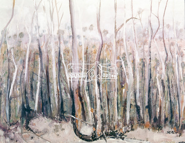
Photograph, "Pindarri" - John Serle, 1968, 1971
... These areas were all heavily timbered, associated grasslands and eucalyptus extending from the thick forest country across undulating hills to the Yarra... The timber in general is gum, oak and Banksia, the two later are small, the gum two to four feet of diameter and from then to thirty feet high; on some of the low ground somewhat larger. ...These areas were all heavily timbered, associated grasslands and eucalyptus extending from the thick forest country across undulating hills to the Yarra... The timber in general is gum, oak and Banksia, the two later are small, the gum two to four feet of diameter and from then to thirty feet high; on some of the low ground somewhat larger. ...Pindarri was the name of the property on which artist John Serle lived on Pindari Road, St. Andrews. Colour painting reproduced on page 11 of "Pioneers & Painters: One hundred years of Eltham and its Shire" by Alan Marshall (1971). This chapter 1 "In the beginning" gives a physical description of the area: "Thick forest covered all the higher mountain ranges .. These areas were all heavily timbered, associated grasslands and eucalyptus extending from the thick forest country across undulating hills to the Yarra... The timber in general is gum, oak and Banksia, the two later are small, the gum two to four feet of diameter and from then to thirty feet high; on some of the low ground somewhat larger. The forest was open with little scrub..." The artist John Serle (born 1928) was the first local artist to become a councilor for the Shire of Eltham. He also worked for the Shire of Eltham grading roads. The Shire of Nillumbik hold a similiar painting in their collection (access via Victorian Collections) titled: Untitled (bush) Donor details on file. Location of original painting unknown. Most probably held in Serle family collection. Painting produced in 1968. Reproduced in "Pioneers and Painters", 1971 This photo forms part of a collection of photographs gathered by the Shire of Eltham for their centenary project book,"Pioneers and Painters: 100 years of the Shire of Eltham" by Alan Marshall (1971). The collection of over 500 images is held in partnership between Eltham District Historical Society and Yarra Plenty Regional Library (Eltham Library) and is now formally known as the 'The Shire of Eltham Pioneers Photograph Collection.' It is significant in being the first community sourced collection representing the places and people of the Shire's first one hundred years.4 x 5 inch colour reversal film (1) Condition: May not be true to colour of original work. Scanned from a 4 x 5 inch colour transparency which was taken c.1970 (approx. 50 years old) and which has undergone significant colour degradation towards the red spectrum. Allowances made for colour cast correction in scan with best guess for white balance. Significant light flare is reflected off glossy surface of original work at camera lens at lower left and right sides causing quality issues.pioneers and painters, sepp, shire of eltham pioneers photograph collection, john serle, pindarrri, bush -
 Eltham District Historical Society Inc
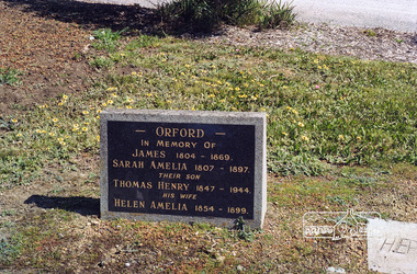
Negative - Photograph, Harry Gilham, Orford family graves, Eltham Cemetery, Victoria, Sep 2009
... Following the death of his wife Helen in 1899, Thomas was appointed by Joseph Panton to look after ‘Panton Park’, a 429-acre bushland property at the fork of Reynolds and Laughing Waters Roads, extending down to the Yarra River. His work entailed ringbarking the manna gums on the property to clear the land for pasture. ...Following the death of his wife Helen in 1899, Thomas was appointed by Joseph Panton to look after ‘Panton Park’, a 429-acre bushland property at the fork of Reynolds and Laughing Waters Roads, extending down to the Yarra River. His work entailed ringbarking the manna gums on the property to clear the land for pasture. ...One of Eltham's earliest settlers was James Orford. Born 1804 in Bedfordshire, the son of George, a carpenter and Lydia Barret, he and wife Sarah Amelia nee Moull (1807) arrived as Assisted Immigrants aboard the ship, ‘Orestes’, November 28, 1839 accompanied by their children, George (14), Mary Ann (11), and James (2). Originally settling in New South Wales, daughter Sarah Amelia was born at Braidwood in 1843 and son, Thomas Henry at Pambula in 1847. James was a carpenter who is known to have built the original gates to Eltham Cemetery. He died in 1869. Around 1890, his son Thomas Henry Orford was living in Pitt Street. Following the death of his wife Helen in 1899, Thomas was appointed by Joseph Panton to look after ‘Panton Park’, a 429-acre bushland property at the fork of Reynolds and Laughing Waters Roads, extending down to the Yarra River. His work entailed ringbarking the manna gums on the property to clear the land for pasture. Thomas lived in a slab hut with his son Ernie, who helped with the work. When Gordon Lyon purchased Panton Park in 1908, Thomas then worked for Lyon at both Panton Park and at ‘Banyule’, Lyon's stud farm at Heidelberg. In 1915 Lyon gave Thomas six acres of land in Reynolds Road with a two-roomed cottage. Thomas died in 1944 and is buried in Eltham Cemetery with his wife and his parents. Another of James Orford's sons was James Matthias Orford. He tried to grow food on land at the end of Laughing Waters Road, but without success. Reputedly the Wurundjeri taught him to swim. He was once imprisoned; when his friend Constable Lawlor invited him to inspect the new bluestone lock-up, Lawlor locked him in and wouldn't release him until he was promised two gallons of beer! ORFORD In Memory Of James 1804 -1869 Sarah Amelia 1807 - 1897 Their son Thomas Henry 1847 - 1944 His wife Helen Amelia 1854 - 1899Roll of 35mm colour negative film, 6 stripsKodak GC 400-9eltham cemetery, gravestones, helen amelia orford, james orford, sarah amelia orford, thomas henry orford, cemetery gates -
 Eltham District Historical Society Inc
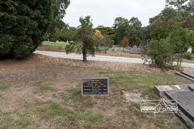
Photograph, Peter Pidgeon, Orford family graves, Eltham Cemetery, Victoria, 5 April 2021
... Following the death of his wife Helen in 1899, Thomas was appointed by Joseph Panton to look after ‘Panton Park’, a 429-acre bushland property at the fork of Reynolds and Laughing Waters Roads, extending down to the Yarra River. His work entailed ringbarking the manna gums on the property to clear the land for pasture. ...Following the death of his wife Helen in 1899, Thomas was appointed by Joseph Panton to look after ‘Panton Park’, a 429-acre bushland property at the fork of Reynolds and Laughing Waters Roads, extending down to the Yarra River. His work entailed ringbarking the manna gums on the property to clear the land for pasture. ...One of Eltham's earliest settlers was James Orford. Born 1804 in Bedfordshire, the son of George, a carpenter and Lydia Barret, he and wife Sarah Amelia nee Moull (1807) arrived as Assisted Immigrants aboard the ship, ‘Orestes’, November 28, 1839 accompanied by their children, George (14), Mary Ann (11), and James (2). Originally settling in New South Wales, daughter Sarah Amelia was born at Braidwood in 1843 and son, Thomas Henry at Pambula in 1847. James was a carpenter who is known to have built the original gates to Eltham Cemetery. He died in 1869. Around 1890, his son Thomas Henry Orford was living in Pitt Street. Following the death of his wife Helen in 1899, Thomas was appointed by Joseph Panton to look after ‘Panton Park’, a 429-acre bushland property at the fork of Reynolds and Laughing Waters Roads, extending down to the Yarra River. His work entailed ringbarking the manna gums on the property to clear the land for pasture. Thomas lived in a slab hut with his son Ernie, who helped with the work. When Gordon Lyon purchased Panton Park in 1908, Thomas then worked for Lyon at both Panton Park and at ‘Banyule’, Lyon's stud farm at Heidelberg. In 1915 Lyon gave Thomas six acres of land in Reynolds Road with a two-roomed cottage. Thomas died in 1944 and is buried in Eltham Cemetery with his wife and his parents. Another of James Orford's sons was James Matthias Orford. He tried to grow food on land at the end of Laughing Waters Road, but without success. Reputedly the Wurundjeri taught him to swim. He was once imprisoned; when his friend Constable Lawlor invited him to inspect the new bluestone lock-up, Lawlor locked him in and wouldn't release him until he was promised two gallons of beer! ORFORD In Memory Of James 1804 -1869 Sarah Amelia 1807 - 1897 Their son Thomas Henry 1847 - 1944 His wife Helen Amelia 1854 - 1899Born Digitaleltham cemetery, gravestones, helen amelia orford, james orford, sarah amelia orford, thomas henry orford -
 Eltham District Historical Society Inc
Book, Diamond Creek Basin Study. Part 1, A Compendium of Factors Relevant to Stormwater Flows, 1980
... gum glade...hurstbridge...kangaroo ground...kinglake escarpment...kinglake national park...latiners hat factory...main road bridge...main road...masons falls...melbourne metropolitan board of works, monash bridge...mount sugarloaf...nillumbik park...orchards...railway culvert...railway line...ramptons road...real estate advertisement...research creek...st helena east drain...st helena road...st helena...storm sewers...stormwater...sugarloaf-preston transfer main crossing...susan street...union mine...village pond...water flow...watkins street...wattletree road...weidlich road...wingrove park...yarra...Eltham District Historical Society Inc 728 Main Rd Eltham melbourne Basin Studies are studies to evaluate water supply and demand and help ensure reliable water supplies by identifying strategies to address imbalances in water supply and demand. aerial photographs allendale road arthurs creek mine arthurs creek road bridge arthurs creek bald spur look-out bank protection bolton steet bridge street bridge bridge street bridges challenger street chute street construction coolaroo drive culvert deep creek diamond creek basin diamond creek region diamond creek diamond street bridge drainage works eltham lower park eltham town park eltham trestle bridge eltham west drains eltham erosion flood management floods footbridge glen katherine estate gold mining gum glade hurstbridge kangaroo ground kinglake escarpment kinglake national park latiners hat factory main road bridge main road masons falls melbourne metropolitan board of works, monash bridge mount sugarloaf nillumbik park orchards railway culvert railway line ramptons road real estate advertisement research creek st helena east drain st helena road st helena storm sewers stormwater sugarloaf-preston transfer main crossing susan street union mine village pond water flow watkins street wattletree road weidlich road wingrove park yarra river zig zag road water supply basin study Spiral Bound. 157 leaves in various foliations (some folded) : illustrated. ...Basin Studies are studies to evaluate water supply and demand and help ensure reliable water supplies by identifying strategies to address imbalances in water supply and demand.Spiral Bound. 157 leaves in various foliations (some folded) : illustrated. (some colour.), maps (some colour.)aerial photographs, allendale road, arthurs creek mine, arthurs creek road bridge, arthurs creek, bald spur look-out, bank protection, bolton steet, bridge street bridge, bridge street, bridges, challenger street, chute street, construction, coolaroo drive, culvert, deep creek, diamond creek basin, diamond creek region, diamond creek, diamond street bridge, drainage works, eltham lower park, eltham town park, eltham trestle bridge, eltham west drains, eltham, erosion, flood management, floods, footbridge, glen katherine estate, gold mining, gum glade, hurstbridge, kangaroo ground, kinglake escarpment, kinglake national park, latiners hat factory, main road bridge, main road, masons falls, melbourne metropolitan board of works, monash bridge, mount sugarloaf, nillumbik park, orchards, railway culvert, railway line, ramptons road, real estate advertisement, research creek, st helena east drain, st helena road, st helena, storm sewers, stormwater, sugarloaf-preston transfer main crossing, susan street, union mine, village pond, water flow, watkins street, wattletree road, weidlich road, wingrove park, yarra river, zig zag road, water supply, basin study -
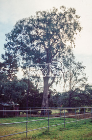
 Eltham District Historical Society Inc
Slide - Photograph, Sugar Gum, 295 Eltham-Yarra Glen Road, Kangaroo Ground, c.2004
... Sugar Gum, 295 Eltham-Yarra Glen Road, Kangaroo Ground...Yarra Glen Road...Heritage tree...Kangaroo Ground...Sugar Gum...Eltham District Historical Society Inc 728 Main Rd Eltham melbourne Part of a presentation on "Significant Trees, Wildflowers and Local Gardens" by Russell Yeoman to the 10 November 2004 Eltham District Historical Society meeting significant tree Eltham-Yarra Glen Road Heritage tree Kangaroo Ground Sugar Gum 35mm colour positive transparency (1 of 36) Mount - white (Pakon) Sugar Gum, 295 Eltham-Yarra Glen Road, Kangaroo Ground Slide Photograph ...Part of a presentation on "Significant Trees, Wildflowers and Local Gardens" by Russell Yeoman to the 10 November 2004 Eltham District Historical Society meeting35mm colour positive transparency (1 of 36) Mount - white (Pakon)significant tree, eltham-yarra glen road, heritage tree, kangaroo ground, sugar gum -
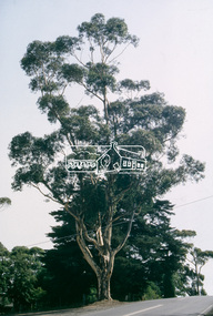 Eltham District Historical Society Inc
Slide - Photograph, Sugar Gum, 295 Eltham-Yarra Glen Road, Kangaroo Ground, c.Mar. 1993
... Sugar Gum, 295 Eltham-Yarra Glen Road, Kangaroo Ground...gum...eltham-yarra glen road...Eltham District Historical Society Inc 728 Main Rd Eltham melbourne significant tree basalt manna gum eltham-yarra glen road kangaroo ground heritage tree sugar gum Production Code "MAR M" 35mm colour positive transparency (1 of 4) Mount - Kodak Ektachrome Sugar Gum, 295 Eltham-Yarra Glen Road, Kangaroo Ground Slide Photograph ...35mm colour positive transparency (1 of 4) Mount - Kodak EktachromeProduction Code "MAR M"significant tree, basalt manna gum, eltham-yarra glen road, kangaroo ground, heritage tree, sugar gum -
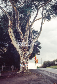 Eltham District Historical Society Inc
Slide - Photograph, World Environment Day 1993, Sugar Gum, 295 Eltham-Yarra Glen Road, Kangaroo Ground, 5 June 1993
... World Environment Day 1993, Sugar Gum, 295 Eltham-Yarra Glen Road, Kangaroo Ground...Yarra Glen Road...Kangaroo Ground...Sugar Gum...According to United Nations, "The celebration of this day provides us with an opportunity to broaden the basis for an enlightened opinion and responsible conduct by individuals, enterprises, and communities in preserving and enhancing the environment." world environment day 1993 heritage tree significant tree Eltham-Yarra Glen Road Kangaroo Ground Sugar Gum 35mm colour positive transparency (1 of 23) Mount - Black and White World Environment Day 1993, Sugar Gum, 295 Eltham-Yarra Glen Road, Kangaroo Ground Slide Photograph ...World Environment Day was established by in 1972 by the United Nations General Assembly on the first day of the Stockholm Conference on the Human Environment. Two years later, in 1974 the first World Environment Day was held with the theme "Only One Earth" and is observed every year on June 5 to encourage awareness and environmental protection. According to United Nations, "The celebration of this day provides us with an opportunity to broaden the basis for an enlightened opinion and responsible conduct by individuals, enterprises, and communities in preserving and enhancing the environment." 35mm colour positive transparency (1 of 23) Mount - Black and Whiteworld environment day 1993, heritage tree, significant tree, eltham-yarra glen road, kangaroo ground, sugar gum -
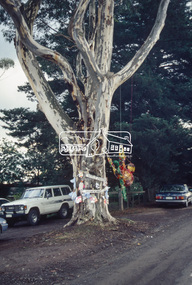 Eltham District Historical Society Inc
Slide - Photograph, World Environment Day 1993, Sugar Gum, 295 Eltham-Yarra Glen Road, Kangaroo Ground, 5 June 1993
... World Environment Day 1993, Sugar Gum, 295 Eltham-Yarra Glen Road, Kangaroo Ground...yarra glen road...kangaroo ground...sugar gum...According to United Nations, "The celebration of this day provides us with an opportunity to broaden the basis for an enlightened opinion and responsible conduct by individuals, enterprises, and communities in preserving and enhancing the environment." world environment day 1993 heritage tree significant tree eltham-yarra glen road kangaroo ground sugar gum 35mm colour positive transparency (1 of 23) Mount - Black and White World Environment Day 1993, Sugar Gum, 295 Eltham-Yarra Glen Road, Kangaroo Ground Slide Photograph ...World Environment Day was established by in 1972 by the United Nations General Assembly on the first day of the Stockholm Conference on the Human Environment. Two years later, in 1974 the first World Environment Day was held with the theme "Only One Earth" and is observed every year on June 5 to encourage awareness and environmental protection. According to United Nations, "The celebration of this day provides us with an opportunity to broaden the basis for an enlightened opinion and responsible conduct by individuals, enterprises, and communities in preserving and enhancing the environment." 35mm colour positive transparency (1 of 23) Mount - Black and Whiteworld environment day 1993, heritage tree, significant tree, eltham-yarra glen road, kangaroo ground, sugar gum