Showing 31 items matching "yarra river -- kew east (vic.)"
-
 Kew Historical Society Inc
Photograph - Yarra River at Kew East, Ron Setford, 1960
... Kew (Vic.) -- 1960s...Yarra River -- Kew East (Vic.)...Yarra Valley over a five year period from c.1972 to c.1977. This important collection was donated to the Society by his granddaughter in 2025. This collection of 175 35mm slides is of local and statewide significance, owing to its subject matter, particularly the major development of road transport infrastructure during the 1970s with the construction of the Eastern Freeway. The photographer also took care to annotate and date most of his slides which enable the researcher to pinpoint temporal and spatial locations. Ron Setford Photographs -- Kew (Vic.) -- 1960s Yarra River -- Kew East ...Ron Setford and his wife Grace Setford lived in Tanner Avenue, East Kew, from c.1946 to c.1995. A keen photographer, he recorded the changing face of Kew over a 20 year period. Apart from 30 photographs of built structures and places in Kew dating from 1960 and 1961, 145 of his 35mm colour slides chronicle the development of the Eastern Freeway through the Yarra Valley over a five year period from c.1972 to c.1977. This important collection was donated to the Society by his granddaughter in 2025.This collection of 175 35mm slides is of local and statewide significance, owing to its subject matter, particularly the major development of road transport infrastructure during the 1970s with the construction of the Eastern Freeway. The photographer also took care to annotate and date most of his slides which enable the researcher to pinpoint temporal and spatial locations.Nilron setford, photographs -- kew (vic.) -- 1960s, yarra river -- kew east (vic.) -
 Kew Historical Society Inc
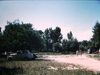
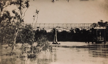
Photograph - Beach near Chipperfield's floating 'Pontoon', Ron Setford, 1960
... Kew (Vic.) -- 1960s...Yarra River -- Kew East (Vic.)...Yarra Valley over a five year period from c.1972 to c.1977. This important collection was donated to the Society by his granddaughter in 2025. This collection of 175 35mm slides is of local and statewide significance, owing to its subject matter, particularly the major development of road transport infrastructure during the 1970s with the construction of the Eastern Freeway. The photographer also took care to annotate and date most of his slides which enable the researcher to pinpoint temporal and spatial locations. Ron Setford Photographs -- Kew (Vic.) -- 1960s Yarra River -- Kew East ...Ron Setford and his wife Grace Setford lived in Tanner Avenue, East Kew, from c.1946 to c.1995. A keen photographer, he recorded the changing face of Kew over a 20 year period. Apart from 30 photographs of built structures and places in Kew dating from 1960 and 1961, 145 of his 35mm colour slides chronicle the development of the Eastern Freeway through the Yarra Valley over a five year period from c.1972 to c.1977. This important collection was donated to the Society by his granddaughter in 2025.This collection of 175 35mm slides is of local and statewide significance, owing to its subject matter, particularly the major development of road transport infrastructure during the 1970s with the construction of the Eastern Freeway. The photographer also took care to annotate and date most of his slides which enable the researcher to pinpoint temporal and spatial locations.Nilron setford, photographs -- kew (vic.) -- 1960s, yarra river -- kew east (vic.), chipperfield's boat house, chipperfield's floating pontoon -
 Kew Historical Society Inc
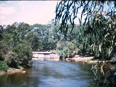
Photograph - Chipperfield's floating 'Pontoon' on the Yarra River, Ron Setford, 1960
... Kew (Vic.) -- 1960s...Yarra River -- Kew East (Vic.)...Yarra Valley over a five year period from c.1972 to c.1977. This important collection was donated to the Society by his granddaughter in 2025. This collection of 175 35mm slides is of local and statewide significance, owing to its subject matter, particularly the major development of road transport infrastructure during the 1970s with the construction of the Eastern Freeway. The photographer also took care to annotate and date most of his slides which enable the researcher to pinpoint temporal and spatial locations. Ron Setford Photographs -- Kew (Vic.) -- 1960s Yarra River -- Kew East ...Ron Setford and his wife Grace Setford lived in Tanner Avenue, East Kew, from c.1946 to c.1995. A keen photographer, he recorded the changing face of Kew over a 20 year period. Apart from 30 photographs of built structures and places in Kew dating from 1960 and 1961, 145 of his 35mm colour slides chronicle the development of the Eastern Freeway through the Yarra Valley over a five year period from c.1972 to c.1977. This important collection was donated to the Society by his granddaughter in 2025.This collection of 175 35mm slides is of local and statewide significance, owing to its subject matter, particularly the major development of road transport infrastructure during the 1970s with the construction of the Eastern Freeway. The photographer also took care to annotate and date most of his slides which enable the researcher to pinpoint temporal and spatial locations.Nilron setford, photographs -- kew (vic.) -- 1960s, yarra river -- kew east (vic.), chipperfield's boat house, chipperfield's floating pontoon -
 Kew Historical Society Inc
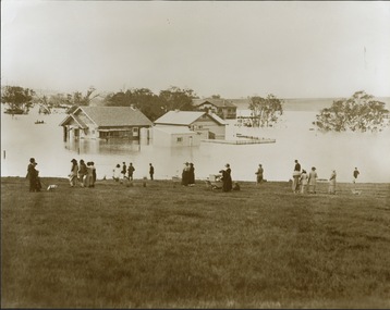
Photograph - Yarra in Flood from Willsmere, North Kew, 1923
... yarra river valley...Kew East (vic...Yarra bordering Kew and Kew East in the north and west of the municipality, was a regular occurrence. Extreme flood events of the Yarra River are recorded to have occurred in 1891, 1901, 1916, 1923 and 1934. The Municipality of Kew's response to these floods was to enact planning decisions restricting residential development in flood prone areas following the floods of 1916, 1921, and 1934. While floods continued after the development of the Upper Yarra Reservoir (construction 1948-57), the regularity and extent of these inundations diminished. yarra river valley Kew East (vic ...Flooding of the Yarra Valley, including that section of the Yarra bordering Kew and Kew East in the north and west of the municipality, was a regular occurrence. Extreme flood events of the Yarra River are recorded to have occurred in 1891, 1901, 1916, 1923 and 1934. The Municipality of Kew's response to these floods was to enact planning decisions restricting residential development in flood prone areas following the floods of 1916, 1921, and 1934. While floods continued after the development of the Upper Yarra Reservoir (construction 1948-57), the regularity and extent of these inundations diminished. Original, large sepia photograph showing men, women and children who have gathered on a grassy verge, probably farm land, to look out across the flooded Yarra Valley at Willsmere, North Kew. In the medium distance are three houses that are largely submerged by the flood waters as well as a number of Eucalypts. Inscribed reverse: "Gift of Kerrie Woollard (KCC) (P)C.1923yarra river valley, kew east (vic.), floods, willsmere -
 Kew Historical Society Inc
Photograph, Marnie McLeod, Floods of the River Yarra at Kew, 1916
... river flats in East Kew are under water. One or two low-lying houses have been flooded. Chipperfield's boat shed at Willsmere is nearly covered, and some Chinese gardens in the vicinity are several feet under water." This, and the other three photographs donated of floods in Kew are believed to be the earliest in the collection. Together with our original MMBW River Yarra map showing flood levels, these items, when compared allow researchers to gain a visual perspective of the extent of the flood in 1916. river yarra kew floods 1916 Inscription on reverse in pencil: "Flood River Yarra Kew Vic" Black and white photograph of flooded trees in Kew with rising dry ground in distance. ...The donation was accompanied by the following letter from the donor: "Hi. I found these in with family photos. Taken by family as Mamie McLeod was living in Fellows Street, Kew, so would be near there. Retain (or discard) as you see fit." [Donor's name and address withheld from public view]. To gain an insight into the flood levels at Kew, it is worth reading newspaper accounts of the event. The Age published an article - Valuable Gardens Destroyed at Kew - on 25 September 1916: "VALUABLE GARDENS DESTROYED AT KEW. From the heights of Studley Park, Kew, a splendid view of the flood waters can be obtained, and yesterday afternoon, despite continuous rain, crowds of citizens assembled there to witness the spectacle. There is a vast stretch of water some 300 or 400 yards broad, above the foot bridge connecting Gipps-street, Collingwood, and Studley Park. The river is only about 3 feet from the top of the embankment connecting with the ramp of the bridge on the Studiey Park side. When the upper llood waters come down it is almost a certainty that tne embankment will be submerged and the bridge rendered impassible. Below the bridge the waters again stretch out, and have submerged all the low-lying land on the Collingwood side and invaded the back premises ot the Kodak Co., Phoenix Biscuit Factory, a tannery adjoining thereto, the Shamrock Brewery, and Chinese gardens in the vicinity. At Walmer-street-bridge, at the end of Studley Park, the low-lying land on the Kew side is covered with water to the depth of many feet. Tlie land in question is owned in a great part by Mr Frank Lavers who haa gone in for intense culture on a pretty liberal scale on both the slopes of the hill and on the river flat. On the latter he is cultivating many acres of asparagus, and has at a considerable cost spent three years in preparing the ground and installing an irrigation system, reticulated from the Yan Yean water supply. This year the asparagus was put down, and the plants were in a promising condition. Tlie flood waters are now flowing fast over the land. The crop is ruined, and three years' work and expenditure destroyed. Mr. Laver's private residence fortunately is high above flood level, but two houses he owns off Young-street have been flooded out. Having been warned in time, the tenants removed their furniture hefore the water came down to Mr. Laver's residence, where they themselves have been given accommodation in the meantime. All the river flats in East Kew are under water. One or two low-lying houses have been flooded. Chipperfield's boat shed at Willsmere is nearly covered, and some Chinese gardens in the vicinity are several feet under water."This, and the other three photographs donated of floods in Kew are believed to be the earliest in the collection. Together with our original MMBW River Yarra map showing flood levels, these items, when compared allow researchers to gain a visual perspective of the extent of the flood in 1916. Black and white photograph of flooded trees in Kew with rising dry ground in distance.Inscription on reverse in pencil: "Flood River Yarra Kew Vic"river yarra, kew, floods 1916 -
 Kew Historical Society Inc
Photograph, Marnie McLeod, Flood, River Yarra, Kew, 1916
... river flats in East Kew are under water. One or two low-lying houses have been flooded. Chipperfield's boat shed at Willsmere is nearly covered, and some Chinese gardens in the vicinity are several feet under water." This, and the other three photographs donated of floods in Kew are believed to be the earliest in the collection. Together with our original MMBW River Yarra map showing flood levels, these items, when compared allow researchers to gain a visual perspective of the extent of the flood in 1916. river yarra kew floods 1916 Inscription on reverse in ink "Flood R. Yarra Kew Vic ...The donation was accompanied by the following letter from the donor: "Hi. I found these in with family photos. Taken by family as Mamie McLeod was living in Fellows Street, Kew, so would be near there. Retain (or discard) as you see fit." [Donor's name and address withheld from public view]. To gain an insight into the flood levels at Kew, it is worth reading newspaper accounts of the event. The Age published an article - Valuable Gardens Destroyed at Kew - on 25 September 1916: "VALUABLE GARDENS DESTROYED AT KEW. From the heights of Studley Park, Kew, a splendid view of the flood waters can be obtained, and yesterday afternoon, despite continuous rain, crowds of citizens assembled there to witness the spectacle. There is a vast stretch of water some 300 or 400 yards broad, above the foot bridge connecting Gipps-street, Collingwood, and Studley Park. The river is only about 3 feet from the top of the embankment connecting with the ramp of the bridge on the Studiey Park side. When the upper llood waters come down it is almost a certainty that tne embankment will be submerged and the bridge rendered impassible. Below the bridge the waters again stretch out, and have submerged all the low-lying land on the Collingwood side and invaded the back premises ot the Kodak Co., Phoenix Biscuit Factory, a tannery adjoining thereto, the Shamrock Brewery, and Chinese gardens in the vicinity. At Walmer-street-bridge, at the end of Studley Park, the low-lying land on the Kew side is covered with water to the depth of many feet. Tlie land in question is owned in a great part by Mr Frank Lavers who haa gone in for intense culture on a pretty liberal scale on both the slopes of the hill and on the river flat. On the latter he is cultivating many acres of asparagus, and has at a considerable cost spent three years in preparing the ground and installing an irrigation system, reticulated from the Yan Yean water supply. This year the asparagus was put down, and the plants were in a promising condition. Tlie flood waters are now flowing fast over the land. The crop is ruined, and three years' work and expenditure destroyed. Mr. Laver's private residence fortunately is high above flood level, but two houses he owns off Young-street have been flooded out. Having been warned in time, the tenants removed their furniture hefore the water came down to Mr. Laver's residence, where they themselves have been given accommodation in the meantime. All the river flats in East Kew are under water. One or two low-lying houses have been flooded. Chipperfield's boat shed at Willsmere is nearly covered, and some Chinese gardens in the vicinity are several feet under water."This, and the other three photographs donated of floods in Kew are believed to be the earliest in the collection. Together with our original MMBW River Yarra map showing flood levels, these items, when compared allow researchers to gain a visual perspective of the extent of the flood in 1916. Small black and white photograph of flooded trees in Kew.Inscription on reverse in ink "Flood R. Yarra Kew Vicriver yarra, kew, floods 1916 -
 Kew Historical Society Inc
Postcard, Macauleys' Boat House, Kew, c.1900
... Kew East. Others depict locations in Victoria or internationally. postcards recreation - yarra river - kew (vic) yarra river - kew (vic) Macauley's boat house -- boat shed "Lower Molesworth Street, 1900. ...The Kew Historical Society's Pictures Collection is comprised of photographs, postcards and original works of art. The postcards include original (mainly) images dating from the 1900s to the present. A number of postcards, some of which have numerous variants, were published as parts of series. Others are original images customised as postcards. Many of the postcards in the collection depict places within the suburbs of Kew and Kew East. Others depict locations in Victoria or internationally.View of two women and two children in a canoe at Macauleys' Boat Shed at the end of Molesworth Street, Kew. At the left of the image stands a man and his dog, presumably the manager of the boat shed. On the bak of the seat of one of the canoes is its name - sunbeam. Another item in the collection includes one of these name boards."Lower Molesworth Street, 1900. Home restored still standing 1980."postcards, recreation - yarra river - kew (vic), yarra river - kew (vic), macauley's boat house -- boat shed -
 Kew Historical Society Inc
Postcard, Yarra Towards Fairfield, 1905-1914
... East. They date from the 1890s to the 2000s. These postcards may or may not include the name of the publisher or printer. A number of the cards were published as parts of popular series. A way of dating early postcards is to identify whether the reverse was divided by a central line which became the norm after 1902 in the United Kingdom. However, other postcards produced after this date do not always conform to this print layout. postcards - kew (vic) river yarra ...The Kew Historical Society's postcard collection includes views of Kew, Melbourne and Greater Melbourne as well as those including overseas scenes sent or received from Europe or the Middle East. They date from the 1890s to the 2000s. These postcards may or may not include the name of the publisher or printer. A number of the cards were published as parts of popular series. A way of dating early postcards is to identify whether the reverse was divided by a central line which became the norm after 1902 in the United Kingdom. However, other postcards produced after this date do not always conform to this print layout.Monochrome postcard showing two men in a rowboat on the River Yarra at Kew in the area of Macaulay's Boat Shed.Handwritten later annotations: "Reg No KH-384. Yarra towards Fairfield. Macaulay's Boat House, Kew"postcards - kew (vic), river yarra - kew (vic), sport and recreation - kew (vic), recreation - kew (vic), boat sheds - kew (vic) -
 Kew Historical Society Inc
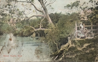
Postcard, River Yarra, Kew, 1905-1914
... East. They date from the 1890s to the 2000s. These postcards may or may not include the name of the publisher or printer. A number of the cards were published as parts of popular series. A way of dating early postcards is to identify whether the reverse was divided by a central line which became the norm after 1902 in the United Kingdom. However, other postcards produced after this date do not always conform to this print layout. One of a series of pictorial postcards showing a woman on a bicycle near to the River Yarra in Kew. postcards -- kew (vic ...The Kew Historical Society's postcard collection includes views of Kew, Melbourne and Greater Melbourne as well as those including overseas scenes sent or received from Europe or the Middle East. They date from the 1890s to the 2000s. These postcards may or may not include the name of the publisher or printer. A number of the cards were published as parts of popular series. A way of dating early postcards is to identify whether the reverse was divided by a central line which became the norm after 1902 in the United Kingdom. However, other postcards produced after this date do not always conform to this print layout.One of a series of pictorial postcards showing a woman on a bicycle near to the River Yarra in Kew.Polychrome postcard of the River Yarra at Kew, showing a woman with a bike (right) looking away from the River.My dear friend I suppose you will think I am a "beauty", but I have no excuse to offer for not writing, only the longer I put it off the longer I want to. I hope the change did you a lot of good & that you feel quite well & strong. Everything here is something about the same. Our two new ministers are nice but I like Mr Dowsing better so far. The weather lately is glorious, just the thing for long walks. Jane Rowe & I go for a walk after church on Sunday nights. That is the most walking I do lately. No room for more. Love from your friend C.G.[sic]postcards -- kew (vic.), postcards -- yarra river -- kew (vic.), colour postcards -- kew (vic.) -
 Kew Historical Society Inc
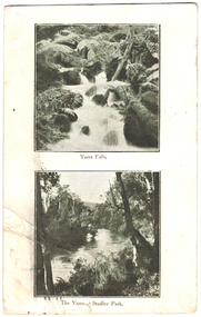
Postcard, Yarra Falls, The Yarra at Studley Park, 1920-1950
... Kew melbourne The Yarra River was a major subject for the producers of postcards in Melbourne. This dual image postcard shows images of the Yarra in two locations. Studley Park in Kew was a major location for recreation activities by the people of Melbourne. Image of the Yarra at Sudley Park shows remnant vegetation preserved on the banks of the Yarra in this part of Kew. yarra falls dual image postcards yarra river -- studley park -- melbourne (vic.) monochrome postcards "Mrs Clark, Harp Road, East Kew / Wishing Mother a very happy Birthday and many returns / from Eileen" Monochrome postcard with two images of the Yarra River, the lower image showing the Yarra at Studley Park. ...The Yarra River was a major subject for the producers of postcards in Melbourne. This dual image postcard shows images of the Yarra in two locations. Studley Park in Kew was a major location for recreation activities by the people of Melbourne.Image of the Yarra at Sudley Park shows remnant vegetation preserved on the banks of the Yarra in this part of Kew.Monochrome postcard with two images of the Yarra River, the lower image showing the Yarra at Studley Park. The reverse has a handwritten birthday greeting from Eileen to her mother Mrs Clark. Original postage stamp has been removed and slight tearing in top right corner. Two ink stamps KEW HISTORICAL SOCIETY have been added."Mrs Clark, Harp Road, East Kew / Wishing Mother a very happy Birthday and many returns / from Eileen"yarra falls, dual image postcards, yarra river -- studley park -- melbourne (vic.), monochrome postcards -
 Kew Historical Society Inc
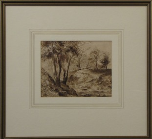
Work on paper - Sepia Wash & Ink, G B Richardson, Creek and Old Watering Stage, on the Yarra, East Collingwood, 1854, 1854
... From 1874 he taught drawing and watercolour painting at Adelaide, where he died on 28 Nov. 1877. gb richardson blind creek - abbotsford yarra river - abbotsford (vic) - kew (vic) colonial artists australian art - 19th century george bouchier richardson Inscribed verso 'Creek and Old Watering stage, on the Yarra East Collingwood 1854 / Trees, stage, &c have long since disappeared / [Artist Signature] / FT 110 / Creek itself now being filled in 1903. ...Blind Creek was located between the Abbotsford Convent and what is now the Collins Bridge in Studley Park. In an 1858 map of East Collingwood by Clement Hodgkinson, in the State Library of Victoria, one can see how the creek was originally a significant landmark in Collingwood; remaining vacant land until a barrel drain enclosed it. The area was later filled in, surveyed and developed. The position where Blind Creek entered the Yarra was in the immediate vicinity of Hodgson’s Punt, which had linked Kew to the other side of the Yarra from 1839. The Punt was purchased by the Colonial Government in 1852 and was in use until the opening of the Studley Park Road (Johnston Street) Bridge in 1858 made its continued use redundantThe point of view selected by the artist for the watercolour is from the banks of Blind Creek in East Collingwood, looking across the Yarra to the Kew side of the river.Inscribed verso 'Creek and Old Watering stage, on the Yarra East Collingwood 1854 / Trees, stage, &c have long since disappeared / [Artist Signature] / FT 110 / Creek itself now being filled in 1903.gb richardson, blind creek - abbotsford, yarra river - abbotsford (vic) - kew (vic), colonial artists, australian art - 19th century, george bouchier richardson -
 Kew Historical Society Inc
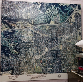
Photograph - Aerial Photograph, Division of Survey and Mapping, Department of Property and Services, City of Kew, Scale 1 : 3,000, 1989, 1989
... Kew Historical Society Inc Kew Court House 188 High Street Kew melbourne The City of Kew was a local government area about 4 kilometres east of Melbourne, the state capital of Victoria, Australia, on the southeast bank of the Yarra River. The city covered an area of 14.56 square kilometres, and existed from 1860 until 1994. city of kew kew (Vic.) aerial photography “City of Kew” Scale 1 : 3,000. 1989. ...The City of Kew was a local government area about 4 kilometres east of Melbourne, the state capital of Victoria, Australia, on the southeast bank of the Yarra River. The city covered an area of 14.56 square kilometres, and existed from 1860 until 1994.Very large aerial photograph of “City of Kew” Scale 1 : 3,000. 1989. “City of Kew” Scale 1 : 3,000. 1989. Photomosaic compiled by Division of Survey and Mapping, Department of Property and Services. © Crown (State of Victoria) Copyright 1990.city of kew, kew (vic.), aerial photography -
 Kew Historical Society Inc
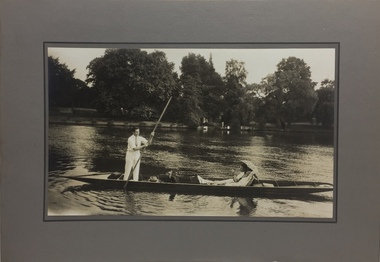
Photograph - John Duncan Brownlee and friends, Yarra River, The Artorium, 1920s
... yarra river (kew) james beament the artorium -- 362 burwood road -- hawthorn (vic.) Three labels on reverse. 1. "John Duncan Brownlee, Operatic Star, originally of Geelong later resident of Kew at Belmont Av, on the pole. Also in the punt - Edith Gardner a friend. The Gardners lived on the east ...This mounted and framed photograph of a group of friends punting on the River Yarra has a number of historic and artistic associations. The photograph is primarily important as an informal photograph of the Australian baritone John Donald Mackenzie Brownlee (1900-1969), whose international career at the world's major opera houses from 1927 until his retirement in 1958 included singing at Melba's Covent Garden farewell in 1926, to recordings in the 1930s of a major series of Mozart operas in Glyndebourne Festival productions, conducted by Fritz Busch. Brownlee, born in Geelong, won the gold medal as champion vocalist at the South Street competitions in Ballarat in 1921. Moving to Paris in 1923 he began study with the French baritone, Dinh Gilly, making his operatic debut at the Trianon Lyrique in Montmartre in 1926. The most significant periods of his operatic career were with the Paris Opera from 1927 to 1936, and at the Metropolitan Opera from 1937 to 1957. After his move to Paris in 1923, he is recorded as revisiting Australia in 1928 as a member of the Melba-Williamson Company, and 24 years later in 1952. The photograph of Brownlee and the Gardners in a punt on the Yarra, while putatively dated to 1925, must be from earlier in the 1920s before his move to Paris, or later during the Melba-Williamson Company season. Before his move to Paris in 1923, Brownlee had lived in Belmont Avenue, Kew, where he must have developed a friendship with the Gardners. The photograph has additional artistic significance as it was produced at 'The Artorium', James Beament's design studio next to the Hawthorn Town Hall at 362 Burwood Road. With a home at 33 Uvadale Road (designed by Eric Nicholls, who managed the architectural practice of Walter Burley and Marion Mahony Grifffin from 1924 to 1932), Beament painted a number of significant murals for the Griffin practice, including those at the Capitol Theatre in Melbourne.A photograph of recreational activities on the River Yarra. The photograph is historically significant as a professionally produced photograph of the Australian operatic baritone John Brownlee, either before his move to Paris in 1923, or in 1928 during the Melba-Williamson Company operatic tour of Australia. The photograph has additional aesthetic significance as it was produced in James Beament's Hawthorn Studio - The Artorium - at 362 Burwood Road, next to the Hawthorn Town Hall.Framed photograph of John Duncan Brownlee, the Australian tenor, with Enid Gardner and friend in a punt on the Yarra River. Brownlee was born in Geelong but before his move to Paris in 1923, he lived for a period in Belmont Avenue, Kew. Three labels on reverse. 1. "John Duncan Brownlee, Operatic Star, originally of Geelong later resident of Kew at Belmont Av, on the pole. Also in the punt - Edith Gardner a friend. The Gardners lived on the east corner of Edgevale Rd. & Cotham. Approx. 1925." 2. "This picture is the property of Kew Historical Society 1/4/79". 3. Tel. Hawthorn 842 THE ARTORIUM ...."john brownlee (tenor), punting, recreation - yarra river (kew), james beament, the artorium -- 362 burwood road -- hawthorn (vic.) -
 Kew Historical Society Inc
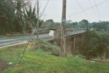
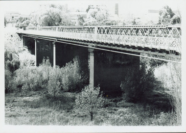
Photograph - Former Chandler Highway Bridge, 2001
... Kew Historical Society Inc Kew Court House 188 High Street Kew melbourne The heritage listed Fairfield Bridge was originally constructed for the Outer Circle Railway to bridge the Yarra River between East Kew and Fairfield stations. In the 1930s it was converted for vehicular traffic. In the 2010s a new concrete bridge was erected beside it to increase vehicular capacity. bridges -- kew (Vic ...The heritage listed Fairfield Bridge was originally constructed for the Outer Circle Railway to bridge the Yarra River between East Kew and Fairfield stations. In the 1930s it was converted for vehicular traffic. In the 2010s a new concrete bridge was erected beside it to increase vehicular capacity. Original colour print positive of the (former) Chandler Highway bridge in 2001. The point of view is from the Fairfield side of the river looking towards Kew. The heritage listed bridge was originally constructed for the Outer Circle Railway to bridge the Yarra River between East Kew and Fairfield stations. In the 1930s it was converted for vehicular traffic. In the 2010s a new concrete bridge was erected beside it to increase vehicular capacity. Ink inscription on reverse: "Chandler Highway bridge / (Originally Outer Circle Railway Bridge) / From Fairfield side towards Kew / July 2001"bridges -- kew (vic), fairfield bridge, chandler highway bridge, outer circle railway viaduct -
 Kew Historical Society Inc
Postcard - Zig-Zag Bridge
... Kew Historical Society Inc Kew Court House 188 High Street Kew melbourne bridges - yarra river -- kew (vic.) zig-zag bridge Reverse: "Old Tramway Bridge / erected early 1850s / Zig Zag Bridge below mental grounds / washed away in flood / linked the mental asylums / donated by G.L. Beard" Sepia postcard of the Zig-Zag Bridge at Kew. The bridge was constructed in the 1870s to link the Yarra Bend Asylum and Kew Asylum. Initially it transported bluestone from the west side of the Yarra to the east ...Sepia postcard of the Zig-Zag Bridge at Kew. The bridge was constructed in the 1870s to link the Yarra Bend Asylum and Kew Asylum. Initially it transported bluestone from the west side of the Yarra to the east during the construction of the Kew Asylum.Reverse: "Old Tramway Bridge / erected early 1850s / Zig Zag Bridge below mental grounds / washed away in flood / linked the mental asylums / donated by G.L. Beard"bridges - yarra river -- kew (vic.), zig-zag bridge -
 Kew Historical Society Inc
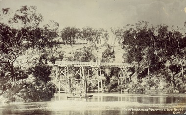
Postcard, J.W.K. & Co, River Yarra near Macauleys' Boathouse Kew, c.1910
... Kew melbourne The Zig-Zag Bridge which was constructed in the 1870s to link the Yarra Bend Asylum and Kew Asylum. Initially it transported bluestone from the west side of the Yarra to the east during the construction of the Kew Asylum. Bridges -- river yarra bridges - kew (vic ...The Zig-Zag Bridge which was constructed in the 1870s to link the Yarra Bend Asylum and Kew Asylum. Initially it transported bluestone from the west side of the Yarra to the east during the construction of the Kew Asylum.Real photo postcard of the Zig-Zag Bridge at Kew. In the middle ground there is a rowboat.Obverse: "River Yarra near Macauleys' Boathouse Kew". Reverse: "Gift from L Bennett"bridges -- river yarra, bridges - kew (vic.), zig-zag bridge -
 Kew Historical Society Inc
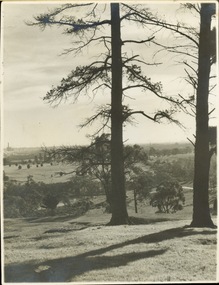
Photograph - Golf course viewed from East Kew, 1940s?
... Kew and Fairfield. Undated but possibly 1930s. Kew (Vic.) Latrobe Golf Course Inscribed reverse: "M Holmes" View of Latrobe Course from the Kew side of the River Yarra. River in middle foreground. Aged pine tree central foreground. Photograph Golf course viewed from East ...Landscape photograph of Kew and Fairfield. Undated but possibly 1930s.View of Latrobe Course from the Kew side of the River Yarra. River in middle foreground. Aged pine tree central foreground. Inscribed reverse: "M Holmes"kew (vic.), latrobe golf course -
 Kew Historical Society Inc
Journal, The Kewriosity Sheet Vol.2 No.3 : August 1980
... Kew in the period 1979-1983. community publications --- kew (vic.) the kewriosity sheet newsletters - kew (vic.) What's doing in Kew for August / p1. Kew Historical Society [George Allan WW2 memorial; Kew Library] / Mavis Rolley p1. St Anne's School - East Kew [50th anniversary of laying of foundation stone] / p1. Epilepsy month / p1. Studley Park Progress Association [Yarra River ...What's doing in Kew for August / p1. Kew Historical Society [George Allan WW2 memorial; Kew Library] / Mavis Rolley p1. St Anne's School - East Kew [50th anniversary of laying of foundation stone] / p1. Epilepsy month / p1. Studley Park Progress Association [Yarra River, Environmental conservation] / Marshall Slattery p2. Greenacres Golf Club / p1. St Hilary's Youth Club / p1. Kintore Social Club / p2. Early landmark of Kew [Kew Court House; Kew Post Office] / Elizabeth Mackie p2. Kew Garden Club / p2. Bowling Club nears century [Kew Bowling Club] / p2.Council News [Kindergarten enrolments; Funds available for local groups; Promoting Kew; Entertainment in Parks; What is R.A.A.V? (Rheumatism and Arthritis Association of Victoria)] / p2. Where have all the people gone? / Rev Stan Simmons p2. Scrabble [Kew Scrabble Club] / p2. Kew & Hawthorn Citizens' Advice Bureau / p2.The Kewriosity Sheet (1979-83) was first published in the City of Kew (Victoria) in June 1979 as a two-sided 'community newssheet'. It aimed to: 'share news about Kew happenings and Kew people, and to exchange ideas about living in Kew'. Later issues gradually evolved into a 4-page, quarto sized publication. The Kewriosity Sheet was superseded by the Kew Council publication 'Kewriosity' (1983-1994).non-fictionWhat's doing in Kew for August / p1. Kew Historical Society [George Allan WW2 memorial; Kew Library] / Mavis Rolley p1. St Anne's School - East Kew [50th anniversary of laying of foundation stone] / p1. Epilepsy month / p1. Studley Park Progress Association [Yarra River, Environmental conservation] / Marshall Slattery p2. Greenacres Golf Club / p1. St Hilary's Youth Club / p1. Kintore Social Club / p2. Early landmark of Kew [Kew Court House; Kew Post Office] / Elizabeth Mackie p2. Kew Garden Club / p2. Bowling Club nears century [Kew Bowling Club] / p2.Council News [Kindergarten enrolments; Funds available for local groups; Promoting Kew; Entertainment in Parks; What is R.A.A.V? (Rheumatism and Arthritis Association of Victoria)] / p2. Where have all the people gone? / Rev Stan Simmons p2. Scrabble [Kew Scrabble Club] / p2. Kew & Hawthorn Citizens' Advice Bureau / p2. community publications --- kew (vic.), the kewriosity sheet, newsletters - kew (vic.) -
 Kew Historical Society Inc
Photograph - Outer Circle Railway Viaduct
... Kew Historical Society Inc Kew Court House 188 High Street Kew melbourne The heritage listed Fairfield Bridge was originally constructed for the Outer Circle Railway to bridge the Yarra River between East Kew and Fairfield stations. In the 1930s it was converted for vehicular traffic. In the 2010s a new concrete bridge was erected beside it to increase vehicular capacity. Railway Viaduct -- Kew (Vic ...The heritage listed Fairfield Bridge was originally constructed for the Outer Circle Railway to bridge the Yarra River between East Kew and Fairfield stations. In the 1930s it was converted for vehicular traffic. In the 2010s a new concrete bridge was erected beside it to increase vehicular capacity.Print copy, enlarged from original snapshot, of the former railway viaduct crossing the Yarra and linking Kew and Fairfield. The original photo predates the conversion of the viaduct into the Chandler Highway Bridge in the 1930s, when the Bridge was adapted to carry vehicular traffic. The date on the reverse indicates the date of donation rather than the date on which the photograph was taken. CHANDLER HIGHWAY BRIDGE OVER RIVER / (ORIGINALLY PART OF OUTER CURCLE RAILWAY) / OCTOBER 1977railway viaduct -- kew (vic.), fairfield bridge, fairfield railway viaduct, outer circle railway, sir john monash -
 Kew Historical Society Inc
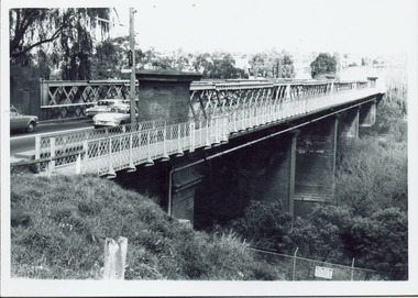
Photograph - Chandler Highway Bridge, 1977
... Kew melbourne The heritage listed Fairfield Bridge was originally constructed for the Outer Circle Railway to bridge the Yarra River between East Kew and Fairfield stations. In the 1930s it was converted for vehicular traffic. In the 2010s a new concrete bridge was erected beside it to increase vehicular capacity. chandler highway bridge outer circle railway viaduct bridges -- kew (Vic.) ...The heritage listed Fairfield Bridge was originally constructed for the Outer Circle Railway to bridge the Yarra River between East Kew and Fairfield stations. In the 1930s it was converted for vehicular traffic. In the 2010s a new concrete bridge was erected beside it to increase vehicular capacity.Print copy of the Chandler Highway Bridge, [formerly the Fairfield Viaduct of the Outer Circle Railway] showing the original position of the walkway beside the bridge. The POV is from the Fairfield side looking towards Kew. CHANDLER HWY BRIDGE OVER YARRA / OCTOBER 1977 / ORIGINALLY BUILT FOR OUTER CIRCLE RWYchandler highway bridge, outer circle railway viaduct, bridges -- kew (vic.) -
 Kew Historical Society Inc
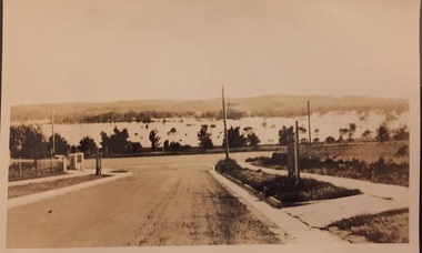
Photograph - River Yarra in Flood from Kilby Road
... Yarra bordering Kew and Kew East in the north and west of the municipality, was a regular occurrence. Extreme flood events of the Yarra River are recorded to have occurred in 1891, 1901, 1916, 1923 and 1934. The Municipality of Kew's response to these floods was to enact planning decisions restricting residential development in flood prone areas following the floods of 1916, 1921 and 1934. While floods continued after the development of the Upper Yarra Reservoir (construction 1948-57), the regularity and extent of these inundations diminished. Kilby Road Floods -- Kew (Vic ...Flooding of the Yarra Valley, including that section of the Yarra bordering Kew and Kew East in the north and west of the municipality, was a regular occurrence. Extreme flood events of the Yarra River are recorded to have occurred in 1891, 1901, 1916, 1923 and 1934. The Municipality of Kew's response to these floods was to enact planning decisions restricting residential development in flood prone areas following the floods of 1916, 1921 and 1934. While floods continued after the development of the Upper Yarra Reservoir (construction 1948-57), the regularity and extent of these inundations diminished.Print copy of an original photo of the River Yarra in Flood, taken from Kilby Road.VIEW ACROSS YARRA IN FLOOD / FROM KILBY RD KEWkilby road, floods -- kew (vic.), kilby farm -
 Kew Historical Society Inc
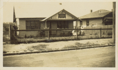
Photograph - 8 Kellett Grove, North Kew, 1929
... Kew East, bordered the Yarra River. As such, it was a region subject to flooding in the Yarra Valley. Development beyond this point (ie Kellett Grove) was limited by the City of Kew's planning regulations. Prior to urban development, the area since European settlement and the first land sales in the district in the 1840s, had been used for dairy farming. 8 Kellett Gove -- North Kew Californian bungalows Houses -- Kellett Grove -- Kew (Vic.) ...North Kew, now divided between Kew and Kew East, bordered the Yarra River. As such, it was a region subject to flooding in the Yarra Valley. Development beyond this point (ie Kellett Grove) was limited by the City of Kew's planning regulations. Prior to urban development, the area since European settlement and the first land sales in the district in the 1840s, had been used for dairy farming. Small sepia snapshot taken of the front of 8 Kellett Grove, in what was then known as North Kew. Verso: 8 KELLETT GROVE / NORTH KEW / 1929 / 418 kellett gove -- north kew, californian bungalows, houses -- kellett grove -- kew (vic.) -
 Kew Historical Society Inc
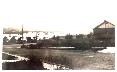
Photograph - Yarra Valley Floods: Kew East, 1916
... Yarra in Kew was devoted to dairy farming. In the twentieth century, before and after the construction of the Eastern Freeway, much of this low-lying area was used as golf courses and public parks. One of a collection of photographs of flooding in the Kew section of the Yarra Valley which are in important research resource for the location and extent of flooding in the first half of the twentieth century. yarra river yarra valley floods -- kew kilby road -- kew (vic.) kew golf club Verso: "Floods along Kilby Road / near Birdwood St? & Kilby Road / 1917? / 87 Flooding of the Yarra Valley at East ...Flooding of the Yarra Valley, including that section of the Yarra bordering Kew and Kew East in the north and west of the municipality, was a regular occurrence. Extreme flood events of the Yarra River are recorded to have occurred in 1891, 1901, 1916, 1923 and 1934. The Municipality of Kew's response to these floods was to enact planning decisions restricting residential development in flood prone areas following the floods of 1916, 1921 and 1934. While floods continued after the development of the Upper Yarra Reservoir (construction 1948-57), the regularity and extent of these inundations diminished. During the nineteenth century, the land abutting the south side of the Yarra in Kew was devoted to dairy farming. In the twentieth century, before and after the construction of the Eastern Freeway, much of this low-lying area was used as golf courses and public parks.One of a collection of photographs of flooding in the Kew section of the Yarra Valley which are in important research resource for the location and extent of flooding in the first half of the twentieth century. Flooding of the Yarra Valley at East Kew in 1916. The view is taken from the intersection of Kilby Road with what is believed to be Birdwood Street, looking across the flood waters to Ivanhoe. The extensive flooded area shown in the photograph would have included the Kew Golf Club. Verso: "Floods along Kilby Road / near Birdwood St? & Kilby Road / 1917? / 87yarra river, yarra valley, floods -- kew, kilby road -- kew (vic.), kew golf club -
 Kew Historical Society Inc
Photograph - Yarra Valley Floods: Kew East, 1916
... Yarra in Kew was devoted to dairy farming. In the twentieth century, before and after the construction of the Eastern Freeway, much of this low-lying area was used as golf courses and public parks. One of a collection of photographs of flooding in the Kew section of the Yarra Valley which are in important research resource for the location and extent of flooding in the first half of the twentieth century. yarra river yarra valley floods -- kew kilby road -- kew (vic.) kew golf club Verso: "Floods / Yarra River / East Kew / Kilby Road / 1917? ...Flooding of the Yarra Valley, including that section of the Yarra bordering Kew and Kew East in the north and west of the municipality, was a regular occurrence. Extreme flood events of the Yarra River are recorded to have occurred in 1891, 1901, 1916, 1923 and 1934. The Municipality of Kew's response to these floods was to enact planning decisions restricting residential development in flood prone areas following the floods of 1916, 1921 and 1934. While floods continued after the development of the Upper Yarra Reservoir (construction 1948-57), the regularity and extent of these inundations diminished. During the nineteenth century, the land abutting the south side of the Yarra in Kew was devoted to dairy farming. In the twentieth century, before and after the construction of the Eastern Freeway, much of this low-lying area was used as golf courses and public parks.One of a collection of photographs of flooding in the Kew section of the Yarra Valley which are in important research resource for the location and extent of flooding in the first half of the twentieth century. Flooding of the Yarra Valley at East Kew in 1916. The view is taken from a street (maybe Birdwood Avenue) intersecting with Kilby Road looking northeast across the flood waters to Ivanhoe and Heidelberg. The extensive flooded area shown in the photograph would have included remnant dairy farms and the Kew Golf Club. Verso: "Floods / Yarra River / East Kew / Kilby Road / 1917? / 87"yarra river, yarra valley, floods -- kew, kilby road -- kew (vic.), kew golf club -
 Kew Historical Society Inc
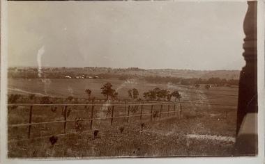
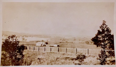
Photograph - Yarra Valley at Kew, 1912
... Yarra in Kew was devoted to dairy farming. In the twentieth century, before and after the construction of the Eastern Freeway, much of this low-lying area was used as golf courses and public parks. yarra river yarra valley farming -- kew (vic.) Verso: "Willsmere / East ...During the nineteenth century, the land abutting the south side of the Yarra in Kew was devoted to dairy farming. In the twentieth century, before and after the construction of the Eastern Freeway, much of this low-lying area was used as golf courses and public parks.Real-photo postcard of the farmland in the Yarra Valley in what is believed to be North Kew in 1912. Verso: "Willsmere / East Kew / 1912"yarra river, yarra valley, farming -- kew (vic.) -
 Kew Historical Society Inc
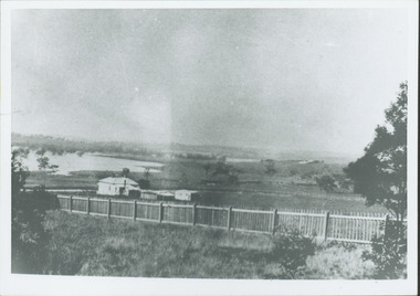
Photograph - Yarra in Flood - Belford & Kilby Farms, 1903
... East Kew, (Vic). Dearly loved wife of the late Harold Bennett, loved mother and mother in law of Laurie and Shirley (Melbourne), Kevin and Doreen (Canberra), grandmother of Linda, Stephen, Paul, Gabrielle, Peter, Mark and Jon." Part of a large collection of photographs and postcards in the collection laurie bennett eileen mary bennett eileen mary clark floods -- yarra -- 1903 Panoramic photographic positive of North Kew where the Belford and Kilby Farms were located on the south side of the Yarra River. ...In 1980, Mr Laurie Bennett presented the Kew Historical Society with a number of photographs and postcards from the estate of his mother Eileen Mary Bennett (nee Clark). His mother was the daughter of Lawrence FH Clark(?-1946) and Mary Clark (?-1925) of 22 Harp Road, East Kew, in whose yard the photograph was taken. A year before the donation occurred a notice appeared in the Canberra Times stating that: "BENNETT, Eileen Mary. — May 8th at Tuross Heads, N.S.W. Late of 22 Harp Rd, East Kew, (Vic). Dearly loved wife of the late Harold Bennett, loved mother and mother in law of Laurie and Shirley (Melbourne), Kevin and Doreen (Canberra), grandmother of Linda, Stephen, Paul, Gabrielle, Peter, Mark and Jon."Part of a large collection of photographs and postcards in the collectionPanoramic photographic positive of North Kew where the Belford and Kilby Farms were located on the south side of the Yarra River. This photo, donated in 1980 by Laurie Bennett is the original of the two identical photos in the collection.laurie bennett, eileen mary bennett, eileen mary clark, floods -- yarra -- 1903 -
 Kew Historical Society Inc
Photograph - Studley Park, 1937
... kew (vic.) Inscribed verso: "Studley Park 1937" Original, black and white positive print of what is said to represent Studley Park in 1937. If the attribution and date is literally to be understood, then it would appear that the photograph may have been taken from the Kew side of the river looking across to open farmland in the Yarra Bend Park. If the designation of Studley Park is to be understood more loosely, then it might be a view of what is now East ...Those sections of Studley Park closest to the River Yarra were set aside as parkland in the 1850s. After initial discussions about whether it was a suitable site for a Government House, much of the land was instead gazetted in the 1860s as the location for a new lunatic asylum, to expand overcrowded mental health facilities at the Yarra Bend Asylum on the other side of the river at Fairfield. Those sections of Studley Park bounded by the Yarra River, Studley Park Road, Princess Street and Fellows Street were subdivided and sold at the Crown Land Sales in 1851. Much of this urban area remained open farmland until the twentieth century, apart from mansions, largely located along the main roads.Original, black and white positive print of what is said to represent Studley Park in 1937. If the attribution and date is literally to be understood, then it would appear that the photograph may have been taken from the Kew side of the river looking across to open farmland in the Yarra Bend Park. If the designation of Studley Park is to be understood more loosely, then it might be a view of what is now East Kew, taken from a section of Kilby Road. Inscribed verso: "Studley Park 1937" studley park -- kew (vic.) -
 Kew Historical Society Inc
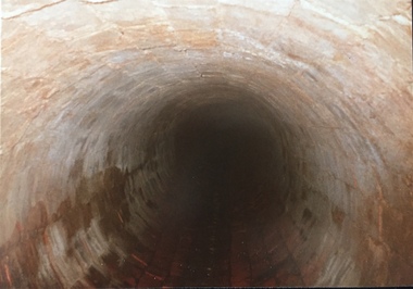
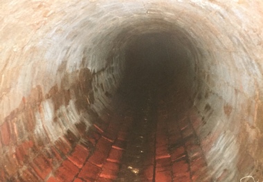
Photograph - Kew Main Drain, 1984
... Kew High School before discharging into the Yarra River. The fourth drain, Kew Main Drain connects directly with the Yarra River to the West of Glass Creek.' The Kew Main Drain is a barrel drain that was created in the 1930s, and follows the route of the former Connor's Creek from the vicinity of Genazzano FCJ College to the Yarra River in East Kew Important and verifiable evidence of the construction methods used by the Melbourne & Metropolitan Board of Works in building the Kew Main Drain, before its reconstruction in c.1985. kew main drain stormwater drains -- kew (vic.) connor's creek -- kew (vic.) ...'Kew, Kew East, Balwyn & Balwyn North are located approximately 7km north east of Melbourne. Four main stormwater drains service the area flowing from south to north. Three of the drains: Deepdene Drain; Balwyn Drain & Glass Creek converge in Kew East just west of Burke Road at Kew High School before discharging into the Yarra River. The fourth drain, Kew Main Drain connects directly with the Yarra River to the West of Glass Creek.' The Kew Main Drain is a barrel drain that was created in the 1930s, and follows the route of the former Connor's Creek from the vicinity of Genazzano FCJ College to the Yarra River in East KewImportant and verifiable evidence of the construction methods used by the Melbourne & Metropolitan Board of Works in building the Kew Main Drain, before its reconstruction in c.1985.Original print colour positive photograph of the Kew Main Drain, provided on 14/12.84 to the Chief Engineer of the City of Kew, Ian Poulter, by the Supervising Engineer (Works), Southern and Eastern Drainage, Melbourne & Metropolitan Board of Works. The record includes an image of the reverse as well as the donation document from the MMBW."A84/1855-9 / 750mm council drain looking D/S [down stream] and across Parkhill Road. To be replaced with 1200 mm R.C.P. [reinforced concrete pipe] as part of MMBW Kew Main Drain reconstruction works"kew main drain, stormwater drains -- kew (vic.), connor's creek -- kew (vic.) -
 Kew Historical Society Inc
Photograph - Kew Main Drain, 1984
... Kew High School before discharging into the Yarra River. The fourth drain, Kew Main Drain connects directly with the Yarra River to the West of Glass Creek.' The Kew Main Drain is a barrel drain that was created in the 1930s, and follows the route of the former Connor's Creek from the vicinity of Genazzano FCJ College to the Yarra River in East Kew Important and verifiable evidence of the construction methods used by the Melbourne & Metropolitan Board of Works in building the Kew Main Drain, before its reconstruction in c.1985. kew main drain stormwater drains -- kew (vic.) connor's creek -- kew (vic.) ...'Kew, Kew East, Balwyn & Balwyn North are located approximately 7km north east of Melbourne. Four main stormwater drains service the area flowing from south to north. Three of the drains: Deepdene Drain; Balwyn Drain & Glass Creek converge in Kew East just west of Burke Road at Kew High School before discharging into the Yarra River. The fourth drain, Kew Main Drain connects directly with the Yarra River to the West of Glass Creek.' The Kew Main Drain is a barrel drain that was created in the 1930s, and follows the route of the former Connor's Creek from the vicinity of Genazzano FCJ College to the Yarra River in East KewImportant and verifiable evidence of the construction methods used by the Melbourne & Metropolitan Board of Works in building the Kew Main Drain, before its reconstruction in c.1985.Original print colour positive photograph of the Kew Main Drain, provided on 14/12.84 to the Chief Engineer of the City of Kew, Ian Poulter, by the Supervising Engineer (Works), Southern and Eastern Drainage, Melbourne & Metropolitan Board of Works. The record includes an image of the reverse as well as the donation document from the MMBW."A84/1855-10 / 750mm council drain looking U/S [up stream] from Parkhill Road, Kew."kew main drain, stormwater drains -- kew (vic.), connor's creek -- kew (vic.) -
 Kew Historical Society Inc
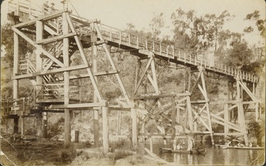
Photograph - Zig-zag Bridge, Kew, Henry Beater Christian, 1920s
... In addition to their aesthetic value, the albums are historically significant records within the State of Victoria, of what is now a distant point in time, and of places that have become radically altered through human intervention. yarra river -- kew (vic) zig-zag bridge -- kew (vic.) henry beater christian christian-washfold collection Sepia photograph of the wooden trestle Zig-Zag Bridge across the River Yarra. The bridge was built in the 1870s to transport stone from the west side of the Yarra to the east ...An item from an outstanding and diverse photographic collection, assembled by members of the Christian family of Pakington Street, Kew, comprising professional and amateur photography, depicting individuals, natural and settled environments and the interactions between these worlds. Many of the photographs vividly capture the worlds of three generations of men - Henry Christian, his son Orlando Henry Beater Christian, and his grandson of Henry Beater Christian. The most important photographer was the youngest, Henry Christian, who was a keen explorer, not just of his immediate environment but also of the Victorian wilderness. His major opus is contained in two albums in which he records, sometimes in majestic detail and on other occasions the intimate features of the natural world. His photographic travels during the 1920s, often in solitary ramblings but on other occasions with companions, recall the heroic landscape photography of an earlier era, pioneered by Nicholas Caire. In addition to their aesthetic value, the albums are historically significant records within the State of Victoria, of what is now a distant point in time, and of places that have become radically altered through human intervention.Sepia photograph of the wooden trestle Zig-Zag Bridge across the River Yarra. The bridge was built in the 1870s to transport stone from the west side of the Yarra to the east side. The stone was used in the construction of the Kew Asylum. The bridge continued to link the two asylums on each side of the river. yarra river -- kew (vic), zig-zag bridge -- kew (vic.), henry beater christian, christian-washfold collection