Showing 21 items matching "yarra yarra golf club"
-
 Heidelberg Golf Club
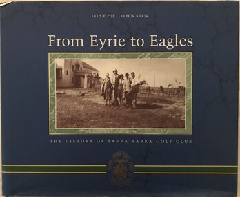
Book, Yarra Yarra Golf Club Ltd, From Eyrie to Eagles: the history of Yarra Yarra Golf Club, 1998
... From Eyrie to Eagles: the history of Yarra Yarra Golf Club...Yarra Yarra Golf Club..."Presented to Heidelberg Golf Club (our sister club) by Yarra Yarra Golf Club. 18th April 1998. ...Yarra Yarra Golf Club Ltd....Heidelberg Golf Club 8 Main Road Lower Plenty 3093 Numbered (00846) edition. Yarra Yarra Golf Club Golf Clubs - History A history of Yarra Yarra Golf Club, founded 1898. ...A history of Yarra Yarra Golf Club, founded 1898.250 p., illus. (some col,)non-fictionA history of Yarra Yarra Golf Club, founded 1898.yarra yarra golf club, golf clubs - history -
 Heidelberg Golf Club
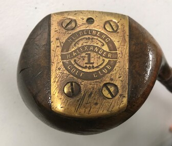
Leisure object - Golf club, Harry Alexander No.1 wood, 1927-1932
... Previously greenkeeper at Yarra Yarra Golf Club, Harry Alexander joined Heidelberg Golf Club in June 1927 to 'set out the new links'. ...Heidelberg Golf Club 8 Main Road Lower Plenty 3093 Previously greenkeeper at Yarra Yarra Golf Club, Harry Alexander joined Heidelberg Golf Club in June 1927 to 'set out the new links'. ...Previously greenkeeper at Yarra Yarra Golf Club, Harry Alexander joined Heidelberg Golf Club in June 1927 to 'set out the new links'. He was the golf professional at HGC from 1927-1932. This club is inscribed with his name and that of the HGCMetal shaft and wooden head, leather grip.On brass plate on base of head: "H. Alexander Heidelberg Golf Club 1"heidelberg golf club, golf clubs, woods, harry alexander, golf professionals -
 Marysville & District Historical Society
THE TRIANGLE NEWS-VOL 39 NO 16-MAY 4 2012
... Marysville & District Historical Society 39 Darwin Street Marysville yarra-valley-and-the-dandenong-ranges marysville victoria australia women encouraged to stand for council nillumbik shire council yarra valley practitioners project new government funding what's on when in may the committee of management of the gallipoli park precinct advertisements creative triangle triangle bushwalkers marysville villains football club marysville triangle branch liberal party of australia progressive lunch church notices vale rev. andrew schreuder st john's church alexandra tributes for rev andrew schreuder marysville golf report narbethong fire brigade black spur inn marysville play group marysville pharmacy marysville medibank clinic call answered for cathedral range triangle community pot luck dinner councillor comment men's big breakfast b.u.i.l.t. narbethong reunion narbethong community hall mother's day lunch marysville triangle real estate old skool all stars band marysville beer & platter garden maryton park b & b kings banquet crossways inn narbethong fire brigade general meeting adventurous cooks string theory marysville cultural community anzac day march marysville & triangle update report acoustic concert expressions of interest worksafe murrindindi shire council morning tea at miss fusspots marysville & district historical society update THE TRIANGLE NEWS-VOL 39 NO 16-MAY 4 2012 ...marysville, victoria, australia, women encouraged to stand for council, nillumbik shire council, yarra valley practitioners project, new government funding, what's on when in may, the committee of management of the gallipoli park precinct, advertisements, creative triangle, triangle bushwalkers, marysville villains football club, marysville triangle branch, liberal party of australia, progressive lunch, church notices, vale rev. andrew schreuder, st john's church alexandra, tributes for rev andrew schreuder, marysville golf report, narbethong fire brigade, black spur inn, marysville play group, marysville pharmacy, marysville medibank clinic, call answered for cathedral range, triangle community pot luck dinner, councillor comment, men's big breakfast, b.u.i.l.t., narbethong reunion, narbethong community hall, mother's day lunch, marysville triangle real estate, old skool all stars band, marysville beer & platter garden, maryton park b & b, kings banquet, crossways inn, narbethong fire brigade general meeting, adventurous cooks, string theory, marysville cultural community, anzac day march, marysville & triangle update report, acoustic concert, expressions of interest, worksafe, murrindindi shire council, morning tea at miss fusspots, marysville & district historical society update -
Marysville & District Historical Society
THE TRIANGLE NEWS-VOL 26 NO 11-26 MARCH 1999
... Marysville & District Historical Society 39 Darwin Street Marysville yarra-valley-and-the-dandenong-ranges marysville victoria australia grapes on the vine golf news fire brigade news country club bowls section country club golf shop sport easter dawn service lions club of upper yarra narbethong c.f.a. autumn golf tournament international einstein year 2005 manical mechanics draft dse fire code at toolangi natural therapies alexandra time out travel healesville from the mayor's chair marysville & district historical society john steavenson photo from england advertisments mary kenealy THE TRIANGLE NEWS-VOL 26 NO 11-26 MARCH 1999 ...marysville, victoria, australia, grapes on the vine, golf news, fire brigade news, country club bowls section, country club golf shop, sport, easter dawn service, lions club of upper yarra, narbethong c.f.a., autumn golf tournament, international einstein year 2005, manical mechanics, draft dse fire code at toolangi, natural therapies alexandra, time out travel healesville, from the mayor's chair, marysville & district historical society, john steavenson photo from england, advertisments, mary kenealy -
Marysville & District Historical Society
THE TRIANGLE NEWS-VOL 27 NO 43-3 NOVEMBER 2000
... Marysville & District Historical Society 39 Darwin Street Marysville yarra-valley-and-the-dandenong-ranges marysville victoria australia our link with history keppel family marysville & district historical society the australia hotel australia day 2001 lions club diary dates mystic mountains tourism marysville & district ratepayers' & residents' assocn advertising rates advertising deadline narbethong fire brigade marysville & district horse riders novelty & games day fire calls murrindindi shire council time out travel healesville advertisements church notices mops old yarra track tea rooms 2001 kinder enrolments street stall community carols minefield campaign igloo roadhouse fm 88 smooth jazz marysville art exhibition golf report cricket club duck race marysville country club bowls section gardening corner flower plot farm nursery mystic mountains open gardens festival murrindindi community health services remembrance day fire brigade news murrindindi valley economic project councillor lyn gunter comments vic roads bike ride grants to boost lake eildon summer fire safety strategy country touch marysville s.e.s. news n.y.e. gallipoli park public notices for sale rural & lifestyle property marketing triangle property news THE TRIANGLE NEWS-VOL 27 NO 43-3 NOVEMBER 2000 ...marysville, victoria, australia, our link with history, keppel family, marysville & district historical society, the australia hotel, australia day 2001, lions club, diary dates, mystic mountains tourism, marysville & district ratepayers' & residents' assocn, advertising rates, advertising deadline, narbethong fire brigade, marysville & district horse riders, novelty & games day, fire calls, murrindindi shire council, time out travel healesville, advertisements, church notices, mops, old yarra track tea rooms, 2001 kinder enrolments, street stall, community carols, minefield campaign, igloo roadhouse, fm 88 smooth jazz, marysville art exhibition, golf report, cricket club, duck race, marysville country club, bowls section, gardening corner, flower plot farm nursery, mystic mountains open gardens festival, murrindindi community health services, remembrance day, fire brigade news, murrindindi valley economic project, councillor lyn gunter comments, vic roads bike ride, grants to boost lake eildon, summer fire safety strategy, country touch, marysville s.e.s. news, n.y.e. gallipoli park, public notices, for sale, rural & lifestyle property marketing, triangle property news -
Marysville & District Historical Society
THE TRIANGLE NEWS-VOL 36 NO 25-JULY 10 2009
... Marysville & District Historical Society 39 Darwin Street Marysville yarra-valley-and-the-dandenong-ranges marysville victoria australia narbethong moving on black spur inn mystic mountain ski hire & outdoors marysville central update marysville triangle real estate emergency services teams james fragga the lolly shop reopens community meetings matdg marysville & triangle phoenix workshop marysville golf and bowls club marysville cricket club marysville & district lions club regional arts funding murrindindi shire council positions vacant advertisements mobile vet service horse property owners narbethong distribution & fire relief store closed after school kid's arts programme festival of healthy living fhl royal children's hospital triangle arts formcraft vic shire of yarra ranges lilydale showgrounds councillor comment church notices interstate support langhorne creek community south australia marysville art show blaney nsw donations buxton strength training marysville medical clinic marysville cricket club trophy presentation THE TRIANGLE NEWS-VOL 36 NO 25-JULY 10 2009 ...marysville, victoria, australia, narbethong moving on, black spur inn, mystic mountain ski hire & outdoors, marysville central update, marysville triangle real estate, emergency services teams, james fragga, the lolly shop reopens, community meetings, matdg, marysville & triangle phoenix workshop, marysville golf and bowls club, marysville cricket club, marysville & district lions club, regional arts funding, murrindindi shire council, positions vacant, advertisements, mobile vet service, horse property owners, narbethong distribution & fire relief store closed, after school kid's arts programme, festival of healthy living, fhl, royal children's hospital, triangle arts, formcraft vic, shire of yarra ranges, lilydale showgrounds, councillor comment, church notices, interstate support, langhorne creek community south australia, marysville art show, blaney nsw donations, buxton strength training, marysville medical clinic, marysville cricket club trophy presentation -
Marysville & District Historical Society
THE TRIANGLE NEWS-VOL 44-NOVEMBER 20 2009
... Marysville & District Historical Society 39 Darwin Street Marysville yarra-valley-and-the-dandenong-ranges marysville victoria australia marysville golf club ilhan charity day challenge marysville community golf and bowls club new school building buxton ridge winery rochford yarra valley alexandra quality meats marysville bakery wildflowers dr lachlan fraser marysville caravan park advertisements ken and christine adams murrindindi shire council THE TRIANGLE NEWS-VOL 44-NOVEMBER 20 2009 ...marysville, victoria, australia, marysville golf club, ilhan charity day challenge, marysville community golf and bowls club, new school building, buxton ridge winery, rochford yarra valley, alexandra quality meats, marysville bakery, wildflowers, dr lachlan fraser, marysville caravan park, advertisements, ken and christine adams, murrindindi shire council -
 Eltham District Historical Society Inc
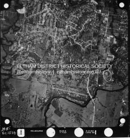
Photograph - Aerial Photograph, Landata, Montmorency / Lower Plenty, Jan. 1962
... Yarra River to south, Main Road, Eltham to east and Heidelberg Golf Club to west. Historic Aerial Imagery Source: Landata.vic.gov.au Aerial Photo Details: Project No : 539 Project : MELBOURNE-GEELONG PROJECT Run : 6 Frame : 81 Date : 01/1962 Film Type : B/W Camera : RC5 Flying Height : 6000 Scale : 15840 Film Number : 1524 GDA2020 : 37°43'52"S, 145°07'26"E MGA2020 : 334685, 5822354 (55) Melways : 21 D9 (ed. 42) Aerial Photo Lower Plenty Main Road Montmorency Phoebe Mason Collection Eltham Eltham Lower Park Heidelberg Golf Club Hurstbridge Railway Line Main Road Eltham Yarra River Electronic PDF file Montmorency / Lower Plenty Photograph Aerial Photograph Landata ...Centred on 147 Old Eltham Road, Lower Plenty bounded by Hurstbridge Railway Line to north, Yarra River to south, Main Road, Eltham to east and Heidelberg Golf Club to west. Historic Aerial Imagery Source: Landata.vic.gov.au Aerial Photo Details: Project No : 539 Project : MELBOURNE-GEELONG PROJECT Run : 6 Frame : 81 Date : 01/1962 Film Type : B/W Camera : RC5 Flying Height : 6000 Scale : 15840 Film Number : 1524 GDA2020 : 37°43'52"S, 145°07'26"E MGA2020 : 334685, 5822354 (55) Melways : 21 D9 (ed. 42)aerial photo, lower plenty, main road, montmorency, phoebe mason collection, eltham, eltham lower park, heidelberg golf club, hurstbridge railway line, main road eltham, yarra river -
 Eltham District Historical Society Inc
Negative - Photograph, J.A. McDonald, Eltham-Yarra Glen Road, Lower Plenty, c. July 1962
... Yarra Glen Road approaching the Lower Plenty Bridge near turn-off for the Golf Club Hotel. Present-day Lower Plenty Road follows a revised alignment across a new bridge. The former bridge is now part of the Plenty River Trail and Edward Willis Court now follows this section of the original Eltham-Yarra Glen Road.. ...Yarra Glen Road approaching the Lower Plenty Bridge near turn-off for the Golf Club Hotel. Present-day Lower Plenty Road follows a revised alignment across a new bridge. The former bridge is now part of the Plenty River Trail and Edward Willis Court now follows this section of the original Eltham-Yarra Glen Road.. The Golf Club Hotel is gone and a new Lower Plenty Hotel was built slightly further up the hill. Record of various Shire of Eltham infrastructure works undertaken during the period of 1952-1962 involving bridge and road reconstruction projects, sometimes with Eltham Shire Council Project Reference numbers quoted. It was during this period that a number of significant improvements were made to roads and new bridges constructed within the shire that remain in place as of present day (2022). In many situations, the photos provide a tangible visible record of infrastructure that existed throughout the early days of the Shire. The album was put together by or under the direction of the Shire Engineer, J.A. McDonald. 1962-07 shire of eltham Old Eltham Road Edward Willis Court Eltham-Yarra ...View looking west across the Eltham-Yarra Glen Road approaching the Lower Plenty Bridge near turn-off for the Golf Club Hotel. Present-day Lower Plenty Road follows a revised alignment across a new bridge. The former bridge is now part of the Plenty River Trail and Edward Willis Court now follows this section of the original Eltham-Yarra Glen Road.. The Golf Club Hotel is gone and a new Lower Plenty Hotel was built slightly further up the hill.Record of various Shire of Eltham infrastructure works undertaken during the period of 1952-1962 involving bridge and road reconstruction projects, sometimes with Eltham Shire Council Project Reference numbers quoted. It was during this period that a number of significant improvements were made to roads and new bridges constructed within the shire that remain in place as of present day (2022). In many situations, the photos provide a tangible visible record of infrastructure that existed throughout the early days of the Shire. The album was put together by or under the direction of the Shire Engineer, J.A. McDonald.1962-07, shire of eltham, old eltham road, edward willis court, eltham-yarra glen road, golf club hotel, infrastructure, lower plenty, road construction -
 Heidelberg Golf Club
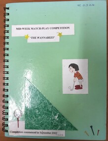
Administrative record - Book, Heidelberg Golf Club, Heidelberg Ladies Pennant mid-week match play "The Wannabees", 2002-2012: Ladies Pennant Book 11, 2002-2012
... Original handwritten names and results of HGC competing in the Yarra courses mid-week match play competition between Rosanna, Heidelberg, Latrobe, Kew, Greenacres and Yarra Valley Golf Clubs, 2002-2012...Heidelberg Golf Club 8 Main Road Lower Plenty 3093 Original handwritten names and results of HGC competing in the Yarra courses mid-week match play competition between Rosanna, Heidelberg, Latrobe, Kew, Greenacres and Yarra Valley Golf Clubs, 2002-2012 Volume 11 of a set of women's pennant results Women's Golf Associates Ladies' Golf Pennant Green spiral bound hardcover notebook. ...Original handwritten names and results of HGC competing in the Yarra courses mid-week match play competition between Rosanna, Heidelberg, Latrobe, Kew, Greenacres and Yarra Valley Golf Clubs, 2002-2012Volume 11 of a set of women's pennant resultsGreen spiral bound hardcover notebook. Handwritten and typed results pasted into book.women's golf, associates, ladies' golf, pennant -
 Heidelberg Golf Club
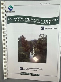
Book, Melbourne Parks and Waterways, Lower Plenty River concept plan: Maroondah Pipe Track to Yarra River, 1994
... Golf Club 8 Main Road Lower Plenty 3093 Lower Plenty River concept plan: Maroondah Pipe Track to Yarra River. Includes suggestion of Plenty River Trail along the west boundary of the Heidelberg Golf Club. Plenty River Trail Lower Plenty River Heidelberg Golf Club MMBW Melbourne Parks and Waterways 66 p., illus., colour map. Also, Draft copy of document. Lower Plenty River concept plan: Maroondah Pipe Track to Yarra ...Lower Plenty River concept plan: Maroondah Pipe Track to Yarra River. Includes suggestion of Plenty River Trail along the west boundary of the Heidelberg Golf Club.66 p., illus., colour map. Also, Draft copy of document.plenty river trail, lower plenty river, heidelberg golf club, mmbw, melbourne parks and waterways -
Box Hill Historical Society
Book, Editor - Catherine Turnbull, Favourite Escapes to the Outer-East. 100 Years of Holidays. Picnics, Excursions and Sporting Carnivals held in the Outer Eastern Region of Melbourne
... Yarra Flats Sabbath School...Bell's Gulf Station...Yarra Glen...McLean> Jack...Box Hill Historical Society...Surrey Hills...Hephzibah Villa...Wilson Hill...Albert Hill...Wilson> Alfred...Wilson> Joseph...Wilson> Caroline (Mrs.)...Smith's gully...Hildebrand> Mr....Hirt> Mr....Harris> R.J. (Mr.)...Dandenong Ranges...Herman> - (Mr.)...Trains...Duncanson> - (Mr.)...Jones> - (Mr.)...Ward> - (Mr.)...Charman> - (Mr.)...Electric Tram...Golf...Huntingdale Golf Club...Head> Isabel Head's Tea Rooms> Ferntree Gully Lilydale Ferntree Gully Yarra Flats Sabbath School Bell's Gulf Station Yarra Glen McLean> Jack Box Hill Historical Society Surrey Hills Hephzibah Villa Wilson Hill Albert Hill Wilson> Alfred Wilson> Joseph Wilson> Caroline (Mrs.) Smith's gully Hildebrand> Mr. Hirt> Mr. Harris> R.J. (Mr.) Dandenong Ranges Herman> - (Mr.) Trains Duncanson> - (Mr.) Jones> - (Mr.) Ward> - (Mr.) Charman> - (Mr.) Electric Tram Golf Huntingdale Golf Club ...Articles submitted by member societies of the Association of Eastern (regional) Historical societies, covering one hundred years of holidays, picnics, excursions and sporting carnivals held in the Outer Eastern regions of Melbourne, 1865-1960. Note the article on "Empire Day Train Services to Surrey Hills 24 th May, 1907" written by Jack Mclean, a member of Box Hill Historical Society.bailey> william, cole> harry, haywood> charlie, gomm> henry t., head> isabel, head's tea rooms> ferntree gully, lilydale, ferntree gully, yarra flats sabbath school, bell's gulf station, yarra glen, mclean> jack, box hill historical society, surrey hills, hephzibah villa, wilson hill, albert hill, wilson> alfred, wilson> joseph, wilson> caroline (mrs.), smith's gully, hildebrand> mr., hirt> mr., harris> r.j. (mr.), dandenong ranges, herman> - (mr.), trains, duncanson> - (mr.), jones> - (mr.), ward> - (mr.), charman> - (mr.), electric tram, golf, huntingdale golf club, metropolitan golf club, reilly> j.l. (mr.), mcculloch family, eastern golf club, maroondah aquaduct, guest houses, sport, golf -
 Kew Historical Society Inc
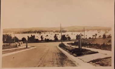
Photograph - Yarra Valley Floods: Kew East, 1916
... yarra river...yarra valley...floods -- kew...kilby road -- kew (vic.)...kew golf club...Yarra in Kew was devoted to dairy farming. In the twentieth century, before and after the construction of the Eastern Freeway, much of this low-lying area was used as golf courses and public parks. One of a collection of photographs of flooding in the Kew section of the Yarra Valley which are in important research resource for the location and extent of flooding in the first half of the twentieth century. yarra river yarra valley floods -- kew kilby road -- kew (vic.) kew golf club Verso: "Floods along Kilby Road / near Birdwood St? ...Flooding of the Yarra Valley, including that section of the Yarra bordering Kew and Kew East in the north and west of the municipality, was a regular occurrence. Extreme flood events of the Yarra River are recorded to have occurred in 1891, 1901, 1916, 1923 and 1934. The Municipality of Kew's response to these floods was to enact planning decisions restricting residential development in flood prone areas following the floods of 1916, 1921 and 1934. While floods continued after the development of the Upper Yarra Reservoir (construction 1948-57), the regularity and extent of these inundations diminished. During the nineteenth century, the land abutting the south side of the Yarra in Kew was devoted to dairy farming. In the twentieth century, before and after the construction of the Eastern Freeway, much of this low-lying area was used as golf courses and public parks.One of a collection of photographs of flooding in the Kew section of the Yarra Valley which are in important research resource for the location and extent of flooding in the first half of the twentieth century. Flooding of the Yarra Valley at East Kew in 1916. The view is taken from the intersection of Kilby Road with what is believed to be Birdwood Street, looking across the flood waters to Ivanhoe. The extensive flooded area shown in the photograph would have included the Kew Golf Club. Verso: "Floods along Kilby Road / near Birdwood St? & Kilby Road / 1917? / 87yarra river, yarra valley, floods -- kew, kilby road -- kew (vic.), kew golf club -
 Kew Historical Society Inc
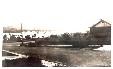
Photograph - Yarra Valley Floods: Kew East, 1916
... yarra river...yarra valley...floods -- kew...kilby road -- kew (vic.)...kew golf club...Yarra in Kew was devoted to dairy farming. In the twentieth century, before and after the construction of the Eastern Freeway, much of this low-lying area was used as golf courses and public parks. One of a collection of photographs of flooding in the Kew section of the Yarra Valley which are in important research resource for the location and extent of flooding in the first half of the twentieth century. yarra river yarra valley floods -- kew kilby road -- kew (vic.) kew golf club Verso: "Floods / Yarra River / East Kew / Kilby Road / 1917? ...Flooding of the Yarra Valley, including that section of the Yarra bordering Kew and Kew East in the north and west of the municipality, was a regular occurrence. Extreme flood events of the Yarra River are recorded to have occurred in 1891, 1901, 1916, 1923 and 1934. The Municipality of Kew's response to these floods was to enact planning decisions restricting residential development in flood prone areas following the floods of 1916, 1921 and 1934. While floods continued after the development of the Upper Yarra Reservoir (construction 1948-57), the regularity and extent of these inundations diminished. During the nineteenth century, the land abutting the south side of the Yarra in Kew was devoted to dairy farming. In the twentieth century, before and after the construction of the Eastern Freeway, much of this low-lying area was used as golf courses and public parks.One of a collection of photographs of flooding in the Kew section of the Yarra Valley which are in important research resource for the location and extent of flooding in the first half of the twentieth century. Flooding of the Yarra Valley at East Kew in 1916. The view is taken from a street (maybe Birdwood Avenue) intersecting with Kilby Road looking northeast across the flood waters to Ivanhoe and Heidelberg. The extensive flooded area shown in the photograph would have included remnant dairy farms and the Kew Golf Club. Verso: "Floods / Yarra River / East Kew / Kilby Road / 1917? / 87"yarra river, yarra valley, floods -- kew, kilby road -- kew (vic.), kew golf club -
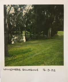 Kew Historical Society Inc
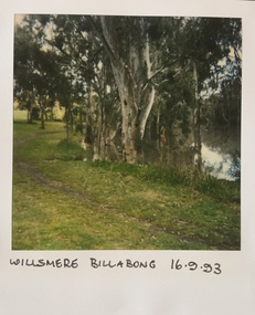
Photograph - Willsmere [Kew] Billabong, 1993
... Yarra River, Green Acres Golf Club, Willow Grove and the Eastern Freeway. The land on which the park is now situated was bought by Thomas Wills at the Crown Land Sales of 1846 (Section 56). From the 1840s to the 1940s it was intensively farmed. The park is dominated by very large playing fields, while planting to the southern boundary was undertaken when the Eastern Freeway was built. It is only along the banks of the Yarra...Yarra River, Green Acres Golf Club, Willow Grove and the Eastern Freeway. The land on which the park is now situated was bought by Thomas Wills at the Crown Land Sales of 1846 (Section 56). From the 1840s to the 1940s it was intensively farmed. The park is dominated by very large playing fields, while planting to the southern boundary was undertaken when the Eastern Freeway was built. It is only along the banks of the Yarra that there is any remnant native vegetation. Willsmere Park is of significance as an area of open land that remains from the flood plain that once dominated northern Kew. (Source: Kew Conservation Study, 1988) kew billabong willsmere park yarra ...Willsmere Park is bounded by the the Yarra River, Green Acres Golf Club, Willow Grove and the Eastern Freeway. The land on which the park is now situated was bought by Thomas Wills at the Crown Land Sales of 1846 (Section 56). From the 1840s to the 1940s it was intensively farmed. The park is dominated by very large playing fields, while planting to the southern boundary was undertaken when the Eastern Freeway was built. It is only along the banks of the Yarra that there is any remnant native vegetation. Willsmere Park is of significance as an area of open land that remains from the flood plain that once dominated northern Kew. (Source: Kew Conservation Study, 1988)Original colour small format polaroid photograph of the 'Kew Billabong' in the Willsmere Park, taken on 16 September 1993."Willsmere Billabong 16.9.93"kew billabong, willsmere park, yarra river -- billabongs -
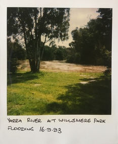 Kew Historical Society Inc
Photograph - Yarra River in flood at the Willsmere Park, 1993
... Yarra River, Green Acres Golf Club, Willow Grove and the Eastern Freeway. The land on which the park is now situated was bought by Thomas Wills at the Crown Land Sales of 1846 (Section 56). From the 1840s to the 1940s it was intensively farmed. The park is dominated by very large playing fields, while planting to the southern boundary was undertaken when the Eastern Freeway was built. It is only along the banks of the Yarra...Yarra River, Green Acres Golf Club, Willow Grove and the Eastern Freeway. The land on which the park is now situated was bought by Thomas Wills at the Crown Land Sales of 1846 (Section 56). From the 1840s to the 1940s it was intensively farmed. The park is dominated by very large playing fields, while planting to the southern boundary was undertaken when the Eastern Freeway was built. It is only along the banks of the Yarra that there is any remnant native vegetation. Willsmere Park is of significance as an area of open land that remains from the flood plain that once dominated northern Kew. (Source: Kew Conservation Study, 1988) willsmere park yarra ...Willsmere Park is bounded by the the Yarra River, Green Acres Golf Club, Willow Grove and the Eastern Freeway. The land on which the park is now situated was bought by Thomas Wills at the Crown Land Sales of 1846 (Section 56). From the 1840s to the 1940s it was intensively farmed. The park is dominated by very large playing fields, while planting to the southern boundary was undertaken when the Eastern Freeway was built. It is only along the banks of the Yarra that there is any remnant native vegetation. Willsmere Park is of significance as an area of open land that remains from the flood plain that once dominated northern Kew. (Source: Kew Conservation Study, 1988)Original colour small format polaroid photograph of the Yarra River in flood at the Willsmere Park, taken on 16 September 1993."Yarra River at Willsmere Park Flooding 16.9.93"willsmere park, yarra river -- floods -- kew (vic.) -
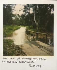 Kew Historical Society Inc
Photograph - Flooding in the Willsmere Park, 1993
... Yarra River, Green Acres Golf Club, Willow Grove and the Eastern Freeway. The land on which the park is now situated was bought by Thomas Wills at the Crown Land Sales of 1846 (Section 56). From the 1840s to the 1940s it was intensively farmed. The park is dominated by very large playing fields, while planting to the southern boundary was undertaken when the Eastern Freeway was built. It is only along the banks of the Yarra...Yarra River, Green Acres Golf Club, Willow Grove and the Eastern Freeway. The land on which the park is now situated was bought by Thomas Wills at the Crown Land Sales of 1846 (Section 56). From the 1840s to the 1940s it was intensively farmed. The park is dominated by very large playing fields, while planting to the southern boundary was undertaken when the Eastern Freeway was built. It is only along the banks of the Yarra that there is any remnant native vegetation. Willsmere Park is of significance as an area of open land that remains from the flood plain that once dominated northern Kew. (Source: Kew Conservation Study, 1988) willsmere park yarra ...Willsmere Park is bounded by the the Yarra River, Green Acres Golf Club, Willow Grove and the Eastern Freeway. The land on which the park is now situated was bought by Thomas Wills at the Crown Land Sales of 1846 (Section 56). From the 1840s to the 1940s it was intensively farmed. The park is dominated by very large playing fields, while planting to the southern boundary was undertaken when the Eastern Freeway was built. It is only along the banks of the Yarra that there is any remnant native vegetation. Willsmere Park is of significance as an area of open land that remains from the flood plain that once dominated northern Kew. (Source: Kew Conservation Study, 1988)Original colour small format polaroid photograph of flooding in the Willsmere Park, taken on 16 September 1993."Flooding of shared path from Willsmere Billabong 16.9.93"willsmere park, yarra river -- floods -- kew (vic.), kew billabong -
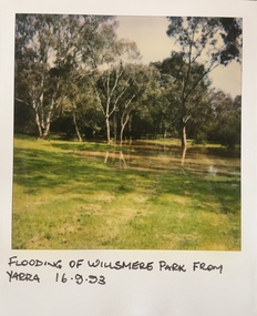 Kew Historical Society Inc
Photograph - Flooding in the Willsmere Park, 1993
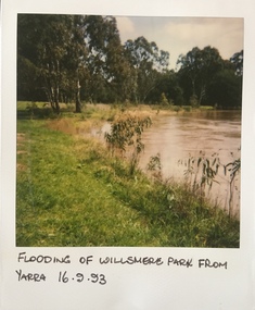
... Yarra River, Green Acres Golf Club, Willow Grove and the Eastern Freeway. The land on which the park is now situated was bought by Thomas Wills at the Crown Land Sales of 1846 (Section 56). From the 1840s to the 1940s it was intensively farmed. The park is dominated by very large playing fields, while planting to the southern boundary was undertaken when the Eastern Freeway was built. It is only along the banks of the Yarra...Yarra River, Green Acres Golf Club, Willow Grove and the Eastern Freeway. The land on which the park is now situated was bought by Thomas Wills at the Crown Land Sales of 1846 (Section 56). From the 1840s to the 1940s it was intensively farmed. The park is dominated by very large playing fields, while planting to the southern boundary was undertaken when the Eastern Freeway was built. It is only along the banks of the Yarra that there is any remnant native vegetation. Willsmere Park is of significance as an area of open land that remains from the flood plain that once dominated northern Kew. (Source: Kew Conservation Study, 1988) willsmere park yarra ...Willsmere Park is bounded by the the Yarra River, Green Acres Golf Club, Willow Grove and the Eastern Freeway. The land on which the park is now situated was bought by Thomas Wills at the Crown Land Sales of 1846 (Section 56). From the 1840s to the 1940s it was intensively farmed. The park is dominated by very large playing fields, while planting to the southern boundary was undertaken when the Eastern Freeway was built. It is only along the banks of the Yarra that there is any remnant native vegetation. Willsmere Park is of significance as an area of open land that remains from the flood plain that once dominated northern Kew. (Source: Kew Conservation Study, 1988)Original colour small format polaroid photograph of flooding in the Willsmere Park, taken on 16 September 1993."Flooding of Willsmere Park from Yarra 16.9.93"willsmere park, yarra river -- floods -- kew (vic.) -
 Kew Historical Society Inc
Photograph - Flooding of Willsmere Park from Yarra, 1993
... Yarra River, Green Acres Golf Club, Willow Grove and the Eastern Freeway. The land on which the park is now situated was bought by Thomas Wills at the Crown Land Sales of 1846 (Section 56). From the 1840s to the 1940s it was intensively farmed. The park is dominated by very large playing fields, while planting to the southern boundary was undertaken when the Eastern Freeway was built. It is only along the banks of the Yarra...Yarra River, Green Acres Golf Club, Willow Grove and the Eastern Freeway. The land on which the park is now situated was bought by Thomas Wills at the Crown Land Sales of 1846 (Section 56). From the 1840s to the 1940s it was intensively farmed. The park is dominated by very large playing fields, while planting to the southern boundary was undertaken when the Eastern Freeway was built. It is only along the banks of the Yarra that there is any remnant native vegetation. Willsmere Park is of significance as an area of open land that remains from the flood plain that once dominated northern Kew. (Source: Kew Conservation Study, 1988) yarra ...Willsmere Park is bounded by the the Yarra River, Green Acres Golf Club, Willow Grove and the Eastern Freeway. The land on which the park is now situated was bought by Thomas Wills at the Crown Land Sales of 1846 (Section 56). From the 1840s to the 1940s it was intensively farmed. The park is dominated by very large playing fields, while planting to the southern boundary was undertaken when the Eastern Freeway was built. It is only along the banks of the Yarra that there is any remnant native vegetation. Willsmere Park is of significance as an area of open land that remains from the flood plain that once dominated northern Kew. (Source: Kew Conservation Study, 1988)Original colour small format polaroid photograph of flooding in Willsmere Park resulting from heavy rain on 15 September 1993."Flooding of Willsmere Park from Yarra 16.9.93"yarra river -- floods -- kew (vic.), willsmere park -
 Kew Historical Society Inc
Photograph - Willsmere [Kew] Billabong, 1993
... Yarra River, Green Acres Golf Club, Willow Grove and the Eastern Freeway. The land on which the park is now situated was bought by Thomas Wills at the Crown Land Sales of 1846 (Section 56). From the 1840s to the 1940s it was intensively farmed. The park is dominated by very large playing fields, while planting to the southern boundary was undertaken when the Eastern Freeway was built. It is only along the banks of the Yarra...Yarra River, Green Acres Golf Club, Willow Grove and the Eastern Freeway. The land on which the park is now situated was bought by Thomas Wills at the Crown Land Sales of 1846 (Section 56). From the 1840s to the 1940s it was intensively farmed. The park is dominated by very large playing fields, while planting to the southern boundary was undertaken when the Eastern Freeway was built. It is only along the banks of the Yarra that there is any remnant native vegetation. Willsmere Park is of significance as an area of open land that remains from the flood plain that once dominated northern Kew. (Source: Kew Conservation Study, 1988) yarra ...Willsmere Park is bounded by the the Yarra River, Green Acres Golf Club, Willow Grove and the Eastern Freeway. The land on which the park is now situated was bought by Thomas Wills at the Crown Land Sales of 1846 (Section 56). From the 1840s to the 1940s it was intensively farmed. The park is dominated by very large playing fields, while planting to the southern boundary was undertaken when the Eastern Freeway was built. It is only along the banks of the Yarra that there is any remnant native vegetation. Willsmere Park is of significance as an area of open land that remains from the flood plain that once dominated northern Kew. (Source: Kew Conservation Study, 1988)Original colour small format polaroid photograph of Willsmere [Kew] Billabong on September 1993."Willsmere Billabong 16.9.93"yarra river -- floods -- kew (vic.), willsmere park -
 Eltham District Historical Society Inc
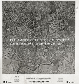
Photograph - Aerial Photograph, Central Plan Office, Eltham, Jan. 1960
... Golf Club...Hurstbridge Railway Line...Main Road Eltham...Yarra River...1960-01...Andrews Street...Arthur Street...Bolton Street...Briar Hill...Brougham Steet...Dave Lyon House...Eltham North...Eltham-Yarra...Yarra River to south, Andrews Street and Euclyptus Road to east and Greensborough Railway Station to west. Historic Aerial Imagery Source: Central Plan Office Neg. No. 21451 (Print) Dept. of Lands & Survey and the Melb. & Metro. Board of Works. Aerial Photo Details: MELBOURNE METROPOLITAN AREA Section : 12 G West Date : Jan./Feb. 1960 Scale : 800 feet to 1 inch 37°43'18.2"S 145°08'13.0"E Melways : 21 J6 (ed. 42) Aerial Photo Lower Plenty Main Road Montmorency Eltham Eltham Lower Park Heidelberg Golf Club Hurstbridge Railway Line Main Road Eltham Yarra River 1960-01 Andrews Street Arthur Street Bolton Street Briar Hill Brougham Steet Dave Lyon House Eltham North Eltham-Yarra Glen Road Ernie Andrew house Eucalyptus Road Greensborough Railway Station henry street Karingal Road Melway 21J6 Montmorency Railway Station Mount Pleasant Road Progress Road railway road Southernwood Were Street Photo print on card 61 x 76 cm Eltham Photograph Aerial Photograph Central Plan Office ...Centred on Bolton Street and Brougham Street, Eltham bounded by Progress Road to north, Yarra River to south, Andrews Street and Euclyptus Road to east and Greensborough Railway Station to west. Historic Aerial Imagery Source: Central Plan Office Neg. No. 21451 (Print) Dept. of Lands & Survey and the Melb. & Metro. Board of Works. Aerial Photo Details: MELBOURNE METROPOLITAN AREA Section : 12 G West Date : Jan./Feb. 1960 Scale : 800 feet to 1 inch 37°43'18.2"S 145°08'13.0"E Melways : 21 J6 (ed. 42)aerial photo, lower plenty, main road, montmorency, eltham, eltham lower park, heidelberg golf club, hurstbridge railway line, main road eltham, yarra river, 1960-01, andrews street, arthur street, bolton street, briar hill, brougham steet, dave lyon house, eltham north, eltham-yarra glen road, ernie andrew house, eucalyptus road, greensborough railway station, henry street, karingal road, melway 21j6, montmorency railway station, mount pleasant road, progress road, railway road, southernwood, were street