Showing 9 items
matching maps, themes: 'creative life','gold rush','immigrants and emigrants'
Diverse state (22)
Aboriginal culture (9)
Built environment (4)
Creative life (3)
Family histories (4)
Gold rush (3)
Immigrants and emigrants (5)
Land and ecology (10)
Local stories (8)
Service and sacrifice (3)
-
Mapping Great Change
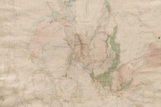
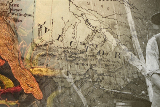
... maps...This series of films and stories is centred on a beautiful and complex map with the ungainly name: Plan of the General Survey from the Town of Malmsbury to the Porcupine Inn, from the sources of Forest Creek to Golden Point, shewing the Alexandrian ...This series of films and stories is centred on a beautiful and complex map with the ungainly name: Plan of the General Survey from the Town of Malmsbury to the Porcupine Inn, from the sources of Forest Creek to Golden Point, shewing the Alexandrian Range, also Sawpit Gully, Bendigo and Bullock Creeks.
In many ways, the map is a mirror of our times: the map is a record of the 'critical years' between 1835 and 1852 in which the dispossession of Aboriginal people of Victoria was allowed to occur; we contemporary people are in the "critical decade" for making the changes necessary to avoid catastrophic climate change.
If we fail to act effectively in this decade, it will be as loaded with moral and practical consequences for coming generations as the moral and policy failures of our colonial ancestors was for the Traditional Owners of the land.
-
 Judy Scurfield
Journey's End
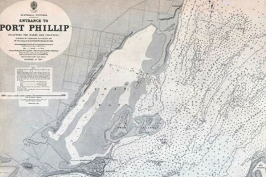
... maps ...Try to imagine yourself on board a sailing ship in the 19th century...
Approaching the entrance to Port Phillip Bay, which is known to be a particularly dangerous harbour entrance, being very narrow (only 2 and a half kilometers across), fringed with rocky reefs, and turbulent because of the tides meeting the ocean swells of Bass Strait.
If you were the Captain you needed an accurate chart showing sea-depths, the coastline and its hazards, but also the navigational aids such as lighthouses and beacons which would guide you into port. You would also have needed a book of sailing directions...
Judy Scurfield, librarian at the State Library of Victoria, asks us to imagine the entry through the most hazardous Port Phillip Heads.
Further material can be found at the State Library of Victoria's Ergo site: Thomas Pierson (Diaries of an early arrival chronicle first impressions of Melbourne).
-
Language, A Key to Survival: Cantonese-English Phrasebooks in Australia
... Map: Locations listed in Zhu's 'English through the Vernaculars of the Canton and Shiuhing Prefectures'..., lists of the English letters written in upper and lower case and in different fonts, lists of key goldfield locations in California and Victoria [see map] and then a selection of useful phrases. Four lines of information are offered for each phrase...Click this link to go to an interactive Google map showing the location of mining sites listed in Zhu's English through the Vernaculars of the Canton and Shiuhing Prefectures (c. 1862). Some place names were misspelled in the phrasebook and so ...Most international travellers today are familiar with phrasebooks. These books provide a guide to pronunciation, useful vocabulary, but most importantly lists of useful phrases to help travellers negotiate their way around a country where they don't speak the language.
Anyone who has tried to communicate across the language divide without such a tool knows how valuable they are.
This web story explores how Chinese from the gold rush period onwards have used phrasebooks to help them find their way in Australia. You can compare examples of Cantonese-English phrasebooks from different eras; watch Museum volunteers Nick and David speak English using a gold-rush era phrasebook; learn a little about the lives of some of the people who owned these phrasebooks; and hear Mr Ng and Mr Leong discuss their experiences learning English in Australia and China in the early to mid-twentieth century.
This project is supported through funding from the Australian Government's Your Community Heritage Program.
-
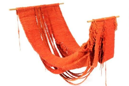
Textiles and Fibre Art
... Art Gallery’s collection provides an invaluable history of textiles and fibre arts, and in doing so, it maps the influential role fibre and textiles have played in extending the boundaries both of visual art and social parameters. Contemporary works ...Established in 1968, Ararat Regional Art Gallery has a unique collection of textiles and fibre art dating from the 1970s, '80s and '90s through to now.
The gallery started collecting work in the 70’s arising from Australia’s growing craft movement – including glass and ceramics. A decision was later made to focus the collection on textiles to reflect the region’s historical association with fine merino wool production. The gallery now has over 1,200 items in its collection, with pivotal works by leading Australian and international artists working in fibre and textiles.
Textiles have been woven from fibre to create clothing and other items since prehistoric times. The 1960’s were a time of great change, with feminism entering the general lexicon and encouraging a questioning of the status quo. Initially aligned with 'women’s work', textiles have become a rich field for both male and female artists to examine gendered roles and social mores, as well as the boundaries of artistic practice.
Ararat Regional Art Gallery’s collection provides an invaluable history of textiles and fibre arts, and in doing so, it maps the influential role fibre and textiles have played in extending the boundaries both of visual art and social parameters.
Contemporary works featured in the gallery’s collection continue this tradition, with Lucas Grogan’s hand embroidered quilt offering a critique of contemporary culture.
Featured here are twenty representative works from the gallery’s textile and fibre art collection. Watch a video to learn about the history of Ararat Regional Art Gallery’s collection and see works by artists John Corbett (Australia), Olga de Amaral (Columbia), Tony Dyer (Australia), Kate Just (USA/Australia), Sebastian Di Mauro (Australia) and Yvonne Koolmatrie (Australia/Ngarrandjeri).
-
Murray Darling Palimpsest #6
... and fittings, auto butyl (inner tube rubber) “Hide nor Hair” - Cowhide, watercolour “Hide Maps” - Cowskins, watercolour (Watercourses and coastlines from Burnt Flat Creek to the sea, sourced from topographic maps of the Central Mapping Authority of NSW ...In 2006, Mildura Palimpsest became the Murray Darling Palimpsest, emphatically underscoring the identity of the region and its environmental interdependence.
The Murray Darling Palimpsest, staged in locations throughout the Murray Darling Basin, continues Palimpsest’s direct engagement with issues of environmental and social sustainability. With land and water use no longer in the background, Palimpsest is remarkable in its recognition that art affects attitudes, and reflects the engagement and connection many contemporary artists have to the environment; perhaps the most pressing issue we now face.
In 2006, Palimpsest brought together artists, scientists, environmentalists and other academics and commentators with the future of the Murray Darling Basin firmly in sight.
-
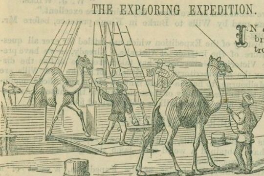
Burke and Wills: Have Camels Will Travel
... map...Map: Wills’s map from Coopers Creek to the Gulf of Carpentaria...This is a detail of Wills' map of the Expedition's route from Cooper's Creek to the Gulf of Carpentaria. Camp CVIII on the Cloncurry River, is named Golah's Camp after one of the camels left behind by the exploration party because ...Dromedary camels were introduced to Australia in 1840. The first significant shipment, however, was made to service the Burke and Wills expedition, which was the first exploring party to use camels, as well as horses, for transporting supplies.
In 1858, George Landells, who had worked as a horse trader in India, wrote to the Victorian Government explaining how the camel was ideally suited to the Australian landscape. He offered to travel to India and purchase camels on behalf of the Victorian government for use in exploration, and as the basis of a breeding stud. The government’s Board of Science and Zoological Gardens Committee agreed that the camel would be useful on the Australian continent, and Landells was authorised to borrow money from the Indian Government and make the purchase.
Landells traveled through India, Pakistan and Afghanistan to source the animals, engaging eight camel drivers to assist him on the journey from Karachi to Melbourne in December 1859, arriving mid-June 1860.
He was hailed for his travels through the ‘very unsettled’ lands by the English Scindian Newspaper, and similarly lauded in Melbourne where the ‘exotic’ animals caused a sensation, as did their handlers, identified variously as Indians, Sepoys, and Malays.
Partly in response to his fame, Landells was appointed second in command of the Burke and Wills expedition. He was also appointed officer in charge of the camels.
Landells recruited John Drakeford and John King, who had helped him bring the animals from Karachi to Melbourne, and four of the eight handlers: Samla (described by Becker as a Hindu), Dost Mahomet (or Botan), from Guznee; Esau Khan (or Hissand or Isaah), Belooch, who came from Mahadpoor in the Punjab, and another man from Kelat.
The expedition party departed Melbourne with 26 camels. As the expedition progressed, Landells and Burke disagreed over their treatment and Landells resigned in Menindee.
Four of the 26 camels were left at Menindee. Dost Mahomet stayed with 16 at the Coopers Creek depot. Burke and Wills took six animals with them on their trek to the Gulf and John King, travelled with them, to care for. Some of the animals strayed or were lost, others were abandoned. Burke, Wills, Charlie Gray and John King ate the last of them, as they struggled back from the Gulf of Carpentaria.
However the Burke and Wills Expedition was not the end of the story. Camels had proved their worth in negotiating the harsh and dry Australian interior and camels became an increasingly important form of transport in the Australian inland. Between 1870 and 1900, over 15,000 camels and 2000 cameleers were brought to Australia. The cameleers were commonly known as “Afghans” although small in number, they made a vital contribution to Australia’s exploration and development.
Feral camels now roam across outback Australia. In response, markets for live camels and camel meat have developed. It is more than likely that the descendents of Landells’ camels are among those that now roam the Australian continent.
-
Possum Skin Cloaks
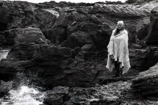
... We made our cloak from willert, which is the possum skin. If we prepared these possum skins in the traditional manner, we would have tanned them with the water bark and then carved the shell or the stone with images of maps of our Country ...CULTURAL WARNING: Aboriginal and Torres Strait Islander users are warned that this material may contain images and voices of deceased persons, and images of places that could cause sorrow.
Continuing the practice of making and wearing possum skin cloaks has strengthened cultural identity and spiritual healing in Aboriginal communities across Victoria.Embodying 5,000 years of tradition, cultural knowledge and ritual, wearing a possum skin cloak can be an emotional experience. Standing on the barren escarpment of Thunder Point with a Djargurd Wurrong cloak around his shoulders, Elder Ivan Couzens felt an enormous sense of pride in what it means to be Aboriginal.
In this story, eight Victorian Elders are pictured on Country and at home in cloaks that they either made or wore at the 2006 Melbourne Commonwealth Games Opening Ceremony.
In a series of videos, the Elders talk about the significance of the cloaks in their lives, explain the meanings of some of the designs and motifs, and reflect on how the cloaks reinforce cultural identity and empower upcoming generations.
Uncle Ivan’s daughter, Vicki Couzens, worked with Lee Darroch, Treahna Hamm and Maree Clarke on the cloak project for the Games. In the essay, Vicki describes the importance of cloaks for spiritual healing in Aboriginal communities and in ceremony in mainstream society.
Traditionally, cloaks were made in South-eastern Australia (from northern NSW down to Tasmania and across to the southern areas of South Australia and West Australia), where there was a cool climate and abundance of possums. From the 1820s, when Indigenous people started living on missions, they were no longer able to hunt and were given blankets for warmth. The blankets, however, did not provide the same level of waterproof protection as the cloaks.
Due to the fragility of the cloaks, and because Aboriginal people were often buried with them, there are few original cloaks remaining. A Gunditjmara cloak from Lake Condah and a Yorta Yorta cloak from Maiden's Punt, Echuca, are held in Museum Victoria's collection. Reproductions of these cloaks are held at the National Museum of Australia.
A number of international institutions also hold original cloaks, including: the Smithsonian Institute (Washington DC), the Museum of Ethnology (Berlin), the British Museum (London) and the Luigi Pigorini National Museum of Prehistory and Ethnography (Rome).
Cloak-making workshops are held across Victoria, NSW and South Australia to facilitate spiritual healing and the continuation of this traditional practice.
-
 Kate Luciano
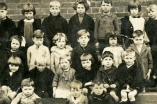
School Days: Education in Victoria
... This 1847 sketch map shows the location of the ‘Mission’ or Merri Creek Aboriginal School. The creek crossing and Protector’s quarters are also shown. ...The exhibition, School Days, developed by Public Record Office Victoria and launched at Old Treasury Building in March 2015, is a history of more than 150 years of schooling in Victoria.
It is a history of the 1872 Education Act - the most significant education reform in Victoria, and a world first! It is a history of early schooling, migrant schooling, Aboriginal schools, women in education, rural education and, of course, education during war time (1914-1918).
This online exhibition is based on the physical exhibition School Days originally displayed at Old Treasury Building, 20 Spring Street, Melbourne, www.oldtreasurybuilding.org.au and curated by Kate Luciano in collaboration with Public Record Office Victoria.
-
 Wind & Sky Productions
Many Roads: Stories of the Chinese on the goldfields
... Map: Complete geographical map of the great Qing Dynasty ...In the 1850s tens of thousands of Chinese people flocked to Victoria, joining people from nations around the world who came here chasing the lure of gold.
Fleeing violence, famine and poverty in their homeland Chinese goldseekers sought fortune for their families in the place they called ‘New Gold Mountain’. Chinese gold miners were discriminated against and often shunned by Europeans. Despite this they carved out lives in this strange new land.
The Chinese took many roads to the goldfields. They left markers, gardens, wells and place names, some which still remain in the landscape today. After a punitive tax was laid on ships to Victoria carrying Chinese passengers, ship captains dropped their passengers off in far away ports, leaving Chinese voyagers to walk the long way hundreds of kilometres overland to the goldfields. After 1857 the sea port of Robe in South Australia became the most popular landing point. It’s estimated 17,000 Chinese, mostly men, predominantly from Southern China, walked to Victoria from Robe following over 400kms of tracks.
At the peak migration point of the late 1850s the Chinese made up one in five of the male population in fabled gold mining towns of Victoria such as Ballarat, Bendigo, Castlemaine, Beechworth and Ararat. It was not just miners who took the perilous journey. Doctors, gardeners, artisans and business people voyaged here and contributed to Victoria’s economy, health and cultural life. As the nineteenth century wore on and successful miners and entrepreneurs returned home, the Chinese Victorian population dwindled. However some chose to settle here and Chinese culture, family life, ceremony and work ethic became a distinctive feature of many regional Victorian towns well into the twentieth century.
By the later twentieth century many of the Chinese relics, landscapes and legacy of the goldrush era were hidden or forgotten. Today we are beginning to unearth and celebrate the extent of the Chinese influence in the making of Victoria, which reaches farther back than many have realised.