Showing 3 items
matching maps, themes: 'service and sacrifice'
-

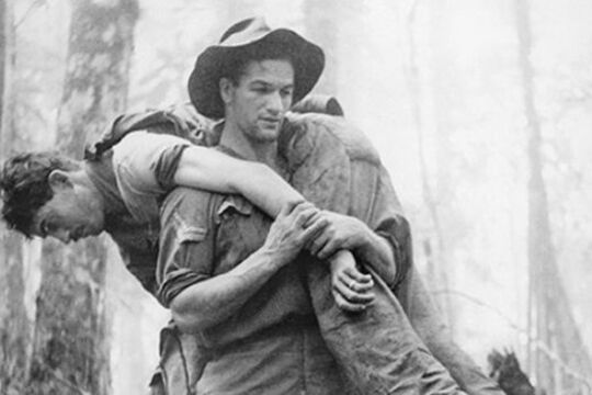
Bull Allen
... Maps...Map: 'New Guinea and Papua', 1934...Map of New Guinea, 1934, at the time the territory was administered by the Australian Commonwealth, before the Japanese invasion of 1942. Australians were significant combatants in the New Guinea campaigns of World War 2. Important campaigns include...Compiled and drawn by Property and Survey Branch, Dept. of the Interior, Canberra, 1933 Map: col., mounted on card ; 55 x 84 cm., on sheet 61 x 89 cm ...Leslie ‘Bull’ Allen was a stretcher-bearer in the Middle East and New Guinea in the Second World War who displayed great bravery in rescuing the wounded.
His most celebrated act of heroism took place on the 30th July 1943 on Mount Tambu in New Guinea. He walked alone into a live battlefield and carried twelve wounded American soldiers out on his shoulders. Bull’s heroism was documented in a famous photograph by war correspondent Gordon Short. Bull was decorated by the US Government and awarded a US Silver Star for bravery, but his action on Tambu was never recognised by the Australian Government.
Born in Ballarat in 1916, Allen came from a background of hardship and poverty. He survived the war, returning home to Ballarat and raising a family, but suffered significant post-traumatic stress from his war experience. He died in 1982.
-
 Walter Barber
The Dreamer & the Cheerful Thing
... stories, a poem or two, much of it typed, some of it hand-written, some official-looking documents and some music scores roughly sorted into manila folders, and a variety of souvenirs and ephemera. There were also half a dozen ordnance maps, aerial ...Some months after my grandfather Bob Snape’s death in 1977 I collected two old trunks full of memorabilia from his last home, in Sandringham.
What a treasure it turned out to be: jammed full of papers, comprising correspondence, diaries, short stories, a poem or two, much of it typed, some of it hand-written, some official-looking documents and some music scores roughly sorted into manila folders, and a variety of souvenirs and ephemera. There were also half a dozen ordnance maps, aerial photographs of some Western Front battlefields and some battered old albums containing postcards, of WW1 France and Belgium, but also of England and Wales. These have since been catalogued on the Warrnambool RSL Victorian Collections page.
Bob’s treasure trove tells the story of his experiences during the war, and that of his younger brother Harold who also fought. Bob was a prolific correspondent and diarist, whilst Harold’s own tiny pocket diary alone ran to approximately 40,000 words. Near the end of his life, Bob told me, “You can burn the lot for all I care. You decide when I’m gone....”
Walter J.R. Barber
-
 Kate Luciano
School Days: Education in Victoria
... This 1847 sketch map shows the location of the ‘Mission’ or Merri Creek Aboriginal School. The creek crossing and Protector’s quarters are also shown. ...The exhibition, School Days, developed by Public Record Office Victoria and launched at Old Treasury Building in March 2015, is a history of more than 150 years of schooling in Victoria.
It is a history of the 1872 Education Act - the most significant education reform in Victoria, and a world first! It is a history of early schooling, migrant schooling, Aboriginal schools, women in education, rural education and, of course, education during war time (1914-1918).
This online exhibition is based on the physical exhibition School Days originally displayed at Old Treasury Building, 20 Spring Street, Melbourne, www.oldtreasurybuilding.org.au and curated by Kate Luciano in collaboration with Public Record Office Victoria.
