Showing 19 items
matching rivers, themes: 'land and ecology'
-

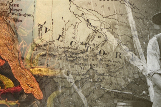
Murray Darling Palimpsest #5
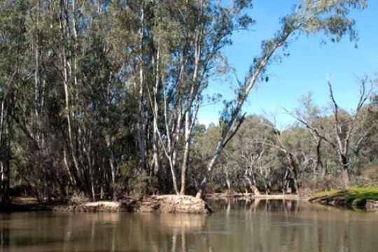
... rivers...Mildura is situated just south-east of the confluence of two of Australia’s great rivers: the Darling and the Murray. As water and land use creep up to the top of our national agenda, the Mildura region emerges as one of Australia’s most contested ...Mildura is situated just south-east of the confluence of two of Australia’s great rivers: the Darling and the Murray.
As water and land use creep up to the top of our national agenda, the Mildura region emerges as one of Australia’s most contested places, with small ‘block’ farmers, multinational companies, State and Federal politics, among others, entering the debate.
As such, it was perhaps the most natural place for the biennial Palimpsest expositions and symposiums to arise. Following on from Mildura’s famous sculpture triennials, Palimpsest plays on the idea of the landscape as palimpsest, written and rewritten over both physically and with layers of meaning. Palimpsest engages directly with land, land use, water and issues of sustainability, involving artists, and scientists and other experts, spearheading the creative exploration of key environmental issues.
-
Drought Stories
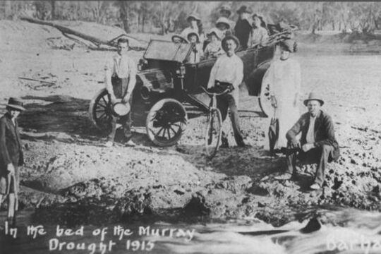
... State Rivers and Water Supply Commission...Audio: Lindsay Smith talks about river health and how farmers have adapted to drought...Lindsay Smith, retired farmer and Chairman of Snape Reserve, near Little Desert National Park, talks to John Francis about the impact of drought, mineral sands mining and tree planting on river health, and how farmers have adapted to drought.... of the River Murray. Drought hit again during World War Two, and then in the period 1965-8. The drought of 1982-3 was short but devastating. Our most recent drought, lasting more than a decade, broke late in 2010 with extensive flooding. Policy responses have ...“The social impact it has is huge, but the footy club survives," says Charlie Gillingham, mixed farmer from Murrabit.
In this story the community talks about drought: its social impact, resilience, changes to farming practises, changing weather patterns and water trading.
The median annual rainfall of the Wimmera and northern plains of Victoria is 420mm. But this median does not convey the deluges that sometimes double the figure, or the dry spells that can halve it. Like semi-arid places elsewhere, the climate cycle of this region is variable.
Aboriginal people have had thousands of years to adapt to the fluctuations, whilst recent settlers are still learning.
The introduction of the Land Act of 1869 accompanied by the high rainfall La Niña years of the early 1870s brought selectors to northern Victoria and the Wimmera. A series of dry years in the 1880s initiated storage and channel projects to assist them to stay.
Irrigation was introduced in 1886 to settle the northern plains and was expanded under closer settlement legislation. The drought years from 1895 to 1902 came to be known as the Federation Drought. Water supplies dried up completely in the El Niño years of 1914 and 1915 and people took the opportunity to picnic in the empty bed of the River Murray.
Drought hit again during World War Two, and then in the period 1965-8. The drought of 1982-3 was short but devastating. Our most recent drought, lasting more than a decade, broke late in 2010 with extensive flooding.
Policy responses have changed over the years and with the recent onset of human induced climate change, continual adaptation will be required.
In 2009, the History Council of Victoria captured resident’s experiences in the project titled Drought Stories: a spoken and visual history of the current drought in Victoria. There were two aims to the project: to create a historic record of the experience, and to strengthen community capacity in rural and regional areas through telling and listening to local stories.
Two types of collections were produced: Drought Stories Local Collections, held by historical societies, and the Drought Stories Central Archive, a selection of interviews held by the State Library of Victoria.
The History Council of Victoria believes that the project material provides a rich resource to assist researchers understand Australian society at a crucial and revealing stage of adjustment to the Australian environment.
Legislation and other land records are held at the Public Record Office Victoria.
-
Murray Darling Palimpsest #6
... rivers...Once was River...Photograph: Once was a River (1)...Alison Coulston & Boyd 'Adrift' Field recordings from Burnt Flat Creek, Wollondilly River, Tasman Sea. Duet for soprano saxophones, composed by Boyd and performed by Paul Cutlan and Sandy Evans. “Coracles” - Cowhide, soldered copper water pipe ...In 2006, Mildura Palimpsest became the Murray Darling Palimpsest, emphatically underscoring the identity of the region and its environmental interdependence.
The Murray Darling Palimpsest, staged in locations throughout the Murray Darling Basin, continues Palimpsest’s direct engagement with issues of environmental and social sustainability. With land and water use no longer in the background, Palimpsest is remarkable in its recognition that art affects attitudes, and reflects the engagement and connection many contemporary artists have to the environment; perhaps the most pressing issue we now face.
In 2006, Palimpsest brought together artists, scientists, environmentalists and other academics and commentators with the future of the Murray Darling Basin firmly in sight.
-
Digital Stories of the Land
... rivers ...Stories of the Land is a collection produced as part of the Australian Centre for the Moving Image (ACMI) digital storytelling program.
These stories explore the land as a thread that connects people to their surroundings. The personal narratives provide a way for understanding place on its own terms and often those terms can be challenging; drought bushfires and isolation for those who live on the land.
People across Victoria have shared stories as part of this ACMI collection capturing the essence of the land as a setting to their lives inextricably linked to the experiences and events that have shaped them.
-
Seeing the Land from an Aboriginal Canoe
... Map: C.J. Tyers and T.S. Townsend, Country between Melbourne and the River Glenelg, Inscription, 1840... and Rick discuss the life of 'King Tommy', an Aboriginal man who lived close by, never far from the Loddon River, in the 19th century....This project explores the significant contribution Aboriginal people made in colonial times by guiding people and stock across the river systems of Victoria. Before European colonisation Aboriginal people managed the place we now know as Victoria ...This project explores the significant contribution Aboriginal people made in colonial times by guiding people and stock across the river systems of Victoria.
Before European colonisation Aboriginal people managed the place we now know as Victoria for millennia. Waterways were a big part of that management. Rivers and waterholes were part of the spiritual landscape, they were valuable sources of food and resources, and rivers were a useful way to travel. Skills such as swimming, fishing, canoe building and navigation were an important aspect of Aboriginal Victorian life.
European explorers and colonists arrived in Victoria from the 1830s onwards. The newcomers dispossessed the Aboriginal people of their land, moving swiftly to the best sites which tended to be close to water resources. At times it was a violent dispossession. There was resistance. There were massacres. People were forcibly moved from their traditional lands. This is well known. What is less well known is the ways Aboriginal people helped the newcomers understand and survive in their new environment. And Victoria’s river system was a significant part of that new environment.
To understand this world we need to cast ourselves back into the 19th century to a time before bridges and cars, where rivers were central to transport and movement of goods and people. All people who lived in this landscape needed water, but water was also dangerous. Rivers flooded. You could drown in them. And in that early period many Europeans did not know how to swim. So there was a real dilemma for the newcomers settling in Victoria – how to safely cross the rivers and use the rivers to transport stock and goods.
The newcomers benefited greatly from Aboriginal navigational skills and the Aboriginal bark canoe.
CULTURAL WARNING: Aboriginal and Torres Strait Islander users are warned that this material may contain images of deceased persons and images of places that could cause sorrow.
-
Pangerang Country with Freddie Dowling
... stories and sites. The Pangerang people were a nation of sub-clans who occupied much of what is now North Eastern Victoria stretching along the Tongala (Murray) River to Echuca and into the areas of the southern Riverina in New South Wales. Their land ...Indigenous Warning: Please be aware that this story contains imagery and representation of people that may be deceased, and images of places that could cause sorrow.
In this story Freddie Dowling, Pangerang Elder, introduces us to several Pangerang stories and sites.
The Pangerang people were a nation of sub-clans who occupied much of what is now North Eastern Victoria stretching along the Tongala (Murray) River to Echuca and into the areas of the southern Riverina in New South Wales. Their land includes the Wangaratta, Yarrawonga and Shepparton areas through which the Kialla (Goulburn) and Torryong (Ovens) Rivers flow. The approximate boundaries are south to Mansfield, west to Echuca, east to Chiltern and north to near Narrandera in New South Wales.
Freddie Dowling learnt the stories of the indigenous people of this area from his grandmother, Annie Lewis, and his father, Frank ‘Munja’ Dowling.
The Pangerang words used in this story were written down by Annie Lewis in 1900. She learned them from her mother, Luana ‘Lily’ Milawa. Freddie remembers that both his grandmother and father spoke these words. His father also taught him to speak while hunting and travelling in the bush of their country.
The word Pangerang is often written and known as Bangerang, and Banerang, 'because, in our language, "puh" and "buh" sound similar' (Freddie Dowling).
-
Early Photographs - Landscapes and Streetscapes
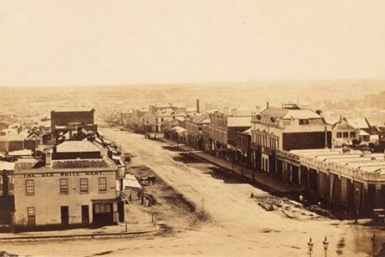
... Yarra River... waterfalls, to the already altered Yarra River, to the dusty corner of Spring and Bourke Streets. Further material can be found at the State Library of Victoria's Ergo site: Early Street Names of Melbourne ...Antoine Fauchery and Richard Daintree's images offer rare fine quality images of early Victorian landscapes and Melbourne streets of the late 1850s.
Antoine Fauchery and Richard Daintree's Sun Pictures of Victoria was the first photographic album of Australian scenes made available for sale to the public.
Using the latest in photographic techniques of the time, the Fauchery-Daintree images offer rare fine quality images of early Victorian landscapes and Melbourne streets of the late 1850s; from pristine waterfalls, to the already altered Yarra River, to the dusty corner of Spring and Bourke Streets.
Further material can be found at the State Library of Victoria's Ergo site: Early Street Names of Melbourne
-
1956 Flood
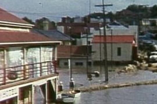
... Murray River...In 1956, a monster flood overwhelmed the banks of the Murray and Darling Rivers, producing floodwaters in surrounding towns and rural areas that reached over 30 feet above normal levels. The Murray Darling Environmental Foundation's 1956 Flood video ...In 1956, a monster flood overwhelmed the banks of the Murray and Darling Rivers, producing floodwaters in surrounding towns and rural areas that reached over 30 feet above normal levels.
The Murray Darling Environmental Foundation's 1956 Flood video features historical footage - including photographs and wonderful super8 film from personal collections - that document the rise and flow of the waters, and the monumental effort mobilised to tackle them.
It is presented here in 3 extracts.
The full video is over 25 minutes long, and copies can be obtained from:
Emma Bradbury, Murray Darling Association, Post Office Box 1268, Echuca 3564
Email: [email protected]
-
But That's Another Story
... This innovative collaboration between community museums and local artists captures the unique living memories and rich cultural heritage of communities along the Murray River between Wodonga and Corryong. Seven short films were created as part ...This innovative collaboration between community museums and local artists captures the unique living memories and rich cultural heritage of communities along the Murray River between Wodonga and Corryong.
Seven short films were created as part of the project:
Nox-All Rabbits: How do you deal with a plague of rabbits? With Nox-All. Rabbiting was a way of life in Victoria, especially during the plague of 1932. Rabbits were a source of food and income (the felt from their pelts used in Akubra hats), and thought by some to be "better than chickens".
Jim Simpson's knitted war trophy: During World War II Jim Simpson's aircraft was shot down over Germany and he became a prisoner of war at Stalag IVB. Jim's ingenuity helped to keep prisoners warm, and ultimately resulted in an extraordinary memorial.
Old time music in the blood: Nariel Creek residents have music in the blood, so much so that they've been told their accordion style is special, using all four fingers at once. The Nariel old time style of Australian traditional music and dance continues with the Nariel Creek Folk Festival.
A history of engine power: Watch out... refurbishing engines can become an addiction. The gem of this collection of over 150 engines is an 1866 Ransom Sims engine, one of only 5 in the world, which has been lovingly restored.
The Saleyards Made Wodonga: Cattle were one of the biggest industries in Wodonga, and the saleyards a focal point town, not least because plum pudding was served in the luncheon room all year round.
The Icon of Wodonga: You need more than a trickle of water to fight a fire. The Wodonga water tower was welcomed as it brought the 'luxury' of water to town, and when it was decommissioned the community rallied to prevent its demolition.
The Saw Doctor's Wagon: The 'Sharpening King' and his family travelled throughout eastern Australia sharpening knives in their 'road urchin'. A circus-like wagon, the urchin was first pulled by horses, then a Chevron truck, and finally, by a David Brown tractor.
Participating museums: Granya Pioneer Museum, Man From Snowy River Museum, Tallangatta & District Heritage Group, Wodonga Historical Society.
Supported by: the Commonwealth Government’s Regional Arts Fund, Regional Arts Victoria, National Museum of Australia, City of Wodonga, Shire of Towong, Museums Australia (Vic) and Arts Victoria. Auspice organisation: Murray Arts
-
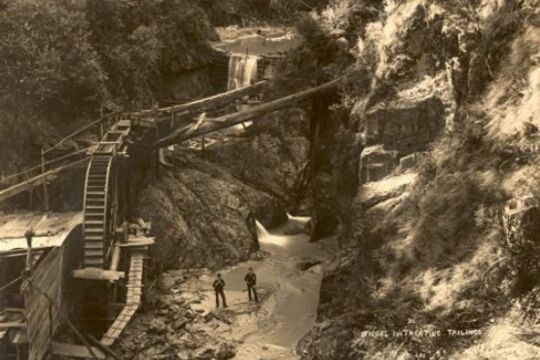
Walhalla: fires, floods and tons of gold
... In a remote, steep, and heavily timbered valley in the Victorian Alps, in the summer of 1862-63, a small party of prospectors found encouraging signs of gold at the fork of a tributary of the Thomson River. It was December. By February of the next ...In a remote, steep, and heavily timbered valley in the Victorian Alps, in the summer of 1862-63, a small party of prospectors found encouraging signs of gold at the fork of a tributary of the Thomson River. It was December. By February of the next year an immense quartz reef had been discovered.
This reef – Cohen’s Reef - yielded over 50 tonnes of gold, making Walhalla one of Victoria’s richest and most vibrant towns, and home to thousands: with hotels, shops, breweries, churches, school, jail and its own newspaper. It also had its own photographic studio, headed by the Lee brothers.
Several albums still survive of Walhalla at its peak, providing a fascinating, evocative photographic record of a 19th century mining town; capturing a moment that was to be shortlived.
In 1910 the railway arrived, but too late: the gold was disappearing. The town emptied out and began its long sleep, until the 1980s when restorations began in earnest, and electricity finally arrived in 1998.
William Joseph Bessell (ex Councillor of the Shire of Walhalla) was presented this series of photos in 1909 on the eve of his departure from Walhalla.
-
 Elizabeth Downes
Tallangatta: The town that moved
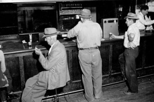
... of water after the Hume Dam was expanded. During 1954 the State Rivers and Water Supply Commission took more than 180 photos in and around the town, documenting houses, businesses and facilities before they were moved. Other images capture the remarkable ...Every now and then, when the Hume Dam is at a low ebb, the ghostly remains of old Tallangatta, in northern Victoria, can be seen above the water. Now located 39 kilometres east of Wodonga, Tallangatta is known as 'the town that moved'.
In 1956, 2 hotels, 4 petrol stations, numerous shops and businesses, 4 churches, more than 900 residents and all the usual public amenities of a country town were relocated 8 kilometres west of the old site. The original location was then flooded under 6 feet of water after the Hume Dam was expanded.
During 1954 the State Rivers and Water Supply Commission took more than 180 photos in and around the town, documenting houses, businesses and facilities before they were moved. Other images capture the remarkable feat of transporting the buildings to the new site, such as a weatherboard house being carefully towed toward a narrow bridge. Many photos give a vivid picture of the commercial centre of a small country town in the mid-1950s. Advertising signs promote Sennitts Icecream and The Argus newspaper, cluttered shops are packed to the gunnels with equipment and staples for small town life before large chain stores, supermarkets and cars changed country towns forever.
The shops and houses are distributed along straight Towong Street. Cars were scarce and bicycles were an important form of transport in the wide and mostly empty streets. Men and women in the 2 hotels were still segregated in the ladies lounge and main bar; and the hotel’s kitchen equipment was basic. The town offered butchers, barbers, and hairdressers, while the garages, plumbers, and hardware stores served both town and farming needs.
The Tallangatta photographs are part of The Rural Water Corporation Collection of more than 50,000 photographs held at The State Library of Victoria. This collection covers a range of water management projects and activities during the first half of the 20th century.
-
 Jary Nemo and Lucinda Horrocks
Collections & Climate Change
... or not ancient glaciers, seas, volcanos, rivers or deserts contributed to the formations we see today. Palaeontology, the study of ancient past life, adds to this understanding of the upheavals caused by climate shifts in Victoria. Fossils, pollens, spores ...The world is changing. Change is a natural part of the Earth’s cycle and of the things that live on it, but what we are seeing now is both like and unlike the shifts we have seen before.
Anthropogenic change, meaning change created by humans, is having an impact on a global scale. In particular, human activity has altered the composition of the Earth’s atmosphere, causing the world’s climate to change.
Already in the state of Victoria we are seeing evidence of this change around us. In the natural world, coastal waters are warming and bringing tropical marine species to our bays. Desert animals are migrating to Victoria. Alpine winters are changing, potentially putting plants and animals at risk of starvation and pushing species closer to the margins. In the world of humans, island and coastal dwellers deal with the tangible and intangible impacts of loss as sea levels rise, bush dwellers live with an increased risk of life-threatening fires, farmers cope with the new normal of longer droughts, and we all face extreme weather events and the impacts of social and economic change.
This Collections and Climate Change digital story explores how Victoria’s scientific and cultural collections help us understand climate change. It focuses on three Victorian institutions - Museums Victoria, the Royal Botanic Gardens Victoria and Parks Victoria. It looks at how the information gathered and maintained by a dedicated community of researchers, curators, scientists, specialists and volunteers can help us understand and prepare for a hotter, drier, more inundated world.
The story is made up of a short documentary film and twenty-one examples highlighting how botanical records, geological and biological specimens and living flora and fauna provide a crucial resource for scientists striving to map continuity, variability and change in the natural world. And it helps us rethink the significance of some of Victoria’s cultural collections in the face of a changing climate.
-
 Isaac Douglas Hermann & Heather Arnold
Carlo Catani: An engineering star over Victoria
... Map: Yarra River improvements... and progressed to the Public Works Department as an assistant engineer. From there Checchi transferred to the Department of Water Supply, and later to the State Rivers & Water Supply Commission, where his significant achievements concerned Murray River ...After more than forty-one years of public service that never ended with his retirement, through surveying and direct design, contracting, supervision, and collaborative approaches, perhaps more than any other single figure, Carlo Catani re-scaped not only parts of Melbourne, but extensive swathes of Victoria ‘from Portland to Mallacoota’, opening up swamplands to farming, bringing access to beauty spots, establishing new townships, and the roads to get us there.
-

Savoy Ladies Group
... and surrounding river valleys – now known as the Ovens, King, Buffalo, Kiewa and Mitta-Mitta Valleys - for tens of thousands of years. European settlers arrived seeking grazing lands for sheep and cattle in the 1830s. The discovery of Gold in Beechworth ...The Italian community of Myrtleford, in the picturesque Ovens Valley in alpine North Eastern Victoria, arrived mainly to work in the tobacco industry which once thrived in the area. The region now has a distinctive Italian-Australian culture with settled second, third and fourth generation Italian families.
Tobacco farming was a lonely experience for many of the Italian women who migrated to Myrtleford. Unlike their husbands, the women stayed largely on the farms and lacked social contact outside of their immediate circle. Once their children grew up and mechanisation changed the labour requirements on the farms, women were frequently on their own.
The Myrtleford Savoy Ladies Group was founded in 1983 by nuns concerned about the social isolation of women in the area. It has been a great success, forming a network of companionship amongst women of Italian heritage to this day.
Cultural Warning: Aboriginal and Torres Strait Islander users of this website are warned that this story contains images of deceased persons and places that could cause sorrow.
-
 Wind & Sky Productions
Many Roads: Stories of the Chinese on the goldfields
... Dynasty's Imperial centre hundreds of kilometres to the north. Guangzhou (Canton) itself was only a short river journey from the Portuguese sea port of Macau and Britain's new island sea port of Hong Kong, established in 1842 as a prize ...In the 1850s tens of thousands of Chinese people flocked to Victoria, joining people from nations around the world who came here chasing the lure of gold.
Fleeing violence, famine and poverty in their homeland Chinese goldseekers sought fortune for their families in the place they called ‘New Gold Mountain’. Chinese gold miners were discriminated against and often shunned by Europeans. Despite this they carved out lives in this strange new land.
The Chinese took many roads to the goldfields. They left markers, gardens, wells and place names, some which still remain in the landscape today. After a punitive tax was laid on ships to Victoria carrying Chinese passengers, ship captains dropped their passengers off in far away ports, leaving Chinese voyagers to walk the long way hundreds of kilometres overland to the goldfields. After 1857 the sea port of Robe in South Australia became the most popular landing point. It’s estimated 17,000 Chinese, mostly men, predominantly from Southern China, walked to Victoria from Robe following over 400kms of tracks.
At the peak migration point of the late 1850s the Chinese made up one in five of the male population in fabled gold mining towns of Victoria such as Ballarat, Bendigo, Castlemaine, Beechworth and Ararat. It was not just miners who took the perilous journey. Doctors, gardeners, artisans and business people voyaged here and contributed to Victoria’s economy, health and cultural life. As the nineteenth century wore on and successful miners and entrepreneurs returned home, the Chinese Victorian population dwindled. However some chose to settle here and Chinese culture, family life, ceremony and work ethic became a distinctive feature of many regional Victorian towns well into the twentieth century.
By the later twentieth century many of the Chinese relics, landscapes and legacy of the goldrush era were hidden or forgotten. Today we are beginning to unearth and celebrate the extent of the Chinese influence in the making of Victoria, which reaches farther back than many have realised.
-
Burke and Wills: Have Camels Will Travel
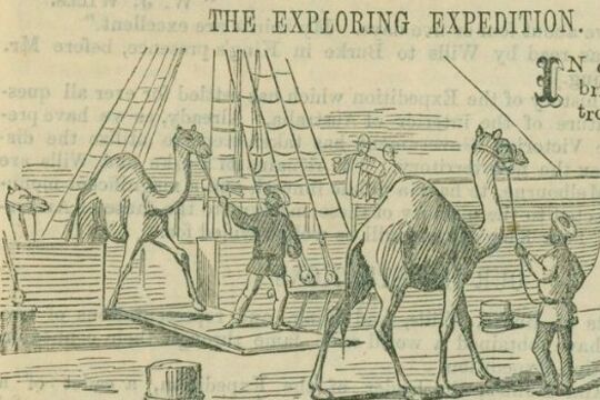
... This is a detail of Wills' map of the Expedition's route from Cooper's Creek to the Gulf of Carpentaria. Camp CVIII on the Cloncurry River, is named Golah's Camp after one of the camels left behind by the exploration party because ...Dromedary camels were introduced to Australia in 1840. The first significant shipment, however, was made to service the Burke and Wills expedition, which was the first exploring party to use camels, as well as horses, for transporting supplies.
In 1858, George Landells, who had worked as a horse trader in India, wrote to the Victorian Government explaining how the camel was ideally suited to the Australian landscape. He offered to travel to India and purchase camels on behalf of the Victorian government for use in exploration, and as the basis of a breeding stud. The government’s Board of Science and Zoological Gardens Committee agreed that the camel would be useful on the Australian continent, and Landells was authorised to borrow money from the Indian Government and make the purchase.
Landells traveled through India, Pakistan and Afghanistan to source the animals, engaging eight camel drivers to assist him on the journey from Karachi to Melbourne in December 1859, arriving mid-June 1860.
He was hailed for his travels through the ‘very unsettled’ lands by the English Scindian Newspaper, and similarly lauded in Melbourne where the ‘exotic’ animals caused a sensation, as did their handlers, identified variously as Indians, Sepoys, and Malays.
Partly in response to his fame, Landells was appointed second in command of the Burke and Wills expedition. He was also appointed officer in charge of the camels.
Landells recruited John Drakeford and John King, who had helped him bring the animals from Karachi to Melbourne, and four of the eight handlers: Samla (described by Becker as a Hindu), Dost Mahomet (or Botan), from Guznee; Esau Khan (or Hissand or Isaah), Belooch, who came from Mahadpoor in the Punjab, and another man from Kelat.
The expedition party departed Melbourne with 26 camels. As the expedition progressed, Landells and Burke disagreed over their treatment and Landells resigned in Menindee.
Four of the 26 camels were left at Menindee. Dost Mahomet stayed with 16 at the Coopers Creek depot. Burke and Wills took six animals with them on their trek to the Gulf and John King, travelled with them, to care for. Some of the animals strayed or were lost, others were abandoned. Burke, Wills, Charlie Gray and John King ate the last of them, as they struggled back from the Gulf of Carpentaria.
However the Burke and Wills Expedition was not the end of the story. Camels had proved their worth in negotiating the harsh and dry Australian interior and camels became an increasingly important form of transport in the Australian inland. Between 1870 and 1900, over 15,000 camels and 2000 cameleers were brought to Australia. The cameleers were commonly known as “Afghans” although small in number, they made a vital contribution to Australia’s exploration and development.
Feral camels now roam across outback Australia. In response, markets for live camels and camel meat have developed. It is more than likely that the descendents of Landells’ camels are among those that now roam the Australian continent.