-
 Heidelberg Golf Club
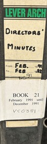
Administrative record - Reports, Heidelberg Golf Club, Directors' Reports: Book 21: February 1991 - December 1991, 1991
Typed reports to Directors of Heidelberg Golf Club from the various sub committees: February 1991 - December 1991Volume 21 of a set of reports to Directors. Black arch file binder, multiple pages, unnumbered. committee reports, directors' reports -
 Bendigo Historical Society Inc.
Map - CITY OF BENDIGO SHEET NO. 4, Circa 1900
Map: City of Bendigo sheet No. 4. Parish plan ( number 218 in Map Cupboard 1)map, bendigo, parish plan, bendigo -
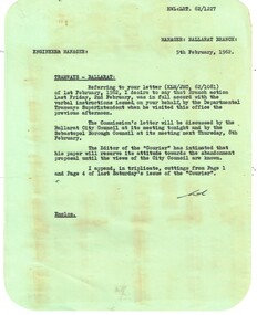 Ballarat Tramway Museum
Administrative record - Memorandum, State Electricity Commission of Victoria (SECV), re letter to City of Ballaarat, Feb. 1962
Yields information about the method of advising SEC Management of letters to the Editor concerning the possible closure of the SEC Ballarat system., Yields information about the method of advising SEC Management of letters to the Editor concerning the possible closure of the SEC Ballarat system.Memorandum to the Engineer & Manager from the Ballarat Manager, on green paper - all with rounded corners, dated 5/2/62, reporting on the Commission's letter to the City Council, that it will be discussed tonight. Editor of Courier holding its attitude until Council's known. Enclosing cuttings - see Reg Item . 7955.trams, tramways, closure, letter to the editor, editorial -
 Bendigo Historical Society Inc.
Map - JACK FLYNN COLLECTION: LAANACOORIE, No date visible
Map: Parish of Laanacoorie, County of Bendigo. Parish plan. Half of the sheet is missing.By Authority H.J. Green. Govt, Printer.map, bendigo, parish plan, laanacoorie -
 Bendigo Historical Society Inc.
Map - JACK FLYNN COLLECTION: BEALIBA, 15/09/1931
Map: Parish of Bealiba, County of Gladstone. Parish plan.By Authority H.J. Green, Government Printer. Photo Lithographed at the Government of Lands and Survey Melbourne. 15.9.31map, gladstone, parish plan, bealiba, gladstone -
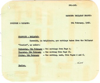 Ballarat Tramway Museum
Administrative record - Memorandum, State Electricity Commission of Victoria (SECV), cuttings from The Courier re possible closure, Feb. 1962
Yields information about the method of advising SEC Management of letters to the Editor concerning the possible closure of the SEC Ballarat system., Yields information about the method of advising SEC Management of letters to the Editor concerning the possible closure of the SEC Ballarat system.Memorandum to the Engineer & Manager from the Ballarat Manager, on green paper - all with rounded corners. 1 - enclosing cuttings from The Courier, 7, 8 and 9/2 (dated 9/2/62) See Reg Item 7950 for these items. trams, tramways, closure, letter to the editor, editorial -
Bendigo Historical Society Inc.
Map - SANDHURST (PART), Circa 1880's
Map: Parish plan showing the area Specimen Hill Road and Inglewood St. ( number 222 in Map Cupboard 1)map, bendigo, parish plan, specimen hill rd. inglewood st. -
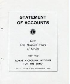 Vision Australia
Administrative record - Text, RVIB Statement of Accounts 1969-1970
Financial information for the Royal Victorian Institute for the Blind, presented as an appendix to the annual report of the institution.1 printed volume of financial information for the RVIBroyal victorian institute for the blind, annual reports -
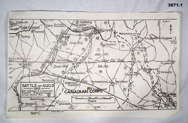 Bendigo Military Museum
Map - MAPS FRANCE WW1, All 1918
(.2) Areas on map relate to : The Hindenburg line on the left, from the top, Bony to Bellicourt to Bellenglise, Estrees to Brancourt. (.3) The River Somme runs through from top corner left bottom corner right. Main areas are Belloy, Picquigny, Bertangles, Montieres. The map finishes just short of “Amiens” Items in the collection relating to F.A.W Hutson No 3539 AIF. refer Cat No 922 for his service history.(.1) Map on paper showing the “Battle of August 1918”, Map C, The Advance to “Lions & Proyart”. (.2) Trench map, gauze lined, sheet 62B N.W, trenches corrected to 8.2.1918, German trenches in blue, scale 1:20,000, France. (.3) Ordnance survey map, May 1918, France, Edition 1, sheet 62 E N.E, scale 1:20,000, a canal and river runs through the centre(.2) On rear hand written “62 B N.W” (.3) On rear hand written “D.M.F 62 E N.E”august 1918, maps, somme -
 Bendigo Historical Society Inc.
Administrative record - Camp Hill State School Collections: Mother's Club Minute Book, June 1967
The Camp Hill State School is a gothic inspired building, completed in 1877, with an initial enrolment of over 1200 students. A deputation had previously been made in 1875 proposing that a school be built. As well as regular classes, night classes for boys were held at Camp Hill from 1879.Red covered Minutes Book, handwritten in ink, from June 1967 to April 1976. known as Camp Hill state School until Feb 1972 when it was changed to Camp Hill Primary School.Written on inside first page "Minute Book, Camp Hill state School, Mother's Club". Price of book $1.79 written in pencil on fly leaf.minutes, mothers'club, 1960s, camp hill state school -
Bendigo Historical Society Inc.
Map - SNOB'S HILL - PLAN OF SNOB'S HILL AREA
Plan drawn on tracing film of sand heap, dams, trig point and mines. Some un-named streets are also drawn in. Piece of notepaper has mines drawn in on a larger scale.map, bendigo, goldfields, snob's hill, plan of snob's hill area, new st mungo mullock heap, duchess trib, s devonshire, duchess of edinburough, w u devonshire, hopewell, phoenix, unicorn, princess alice, lady barkly, sadowa, e u devonshire, united devonshire, l?, ellenborough, belmont & saxby, snob's hill -
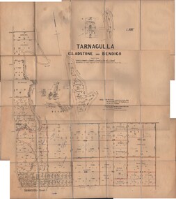 Bendigo Historical Society Inc.
Map - JACK FLYNN COLLECTION: TARNAGULLA SHEET 1, No date visible
Map: Parish of Tarnagulla Sheet 1, Counties of Gladstone and Bendigo.map, gladstone, parish plan, tarnagulla sheet 1 -
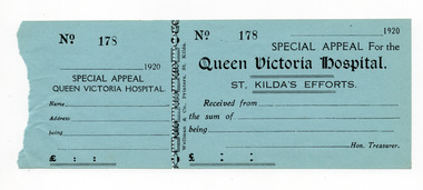 St Kilda Historical Society
Financial record - Receipt form, Special Appeal for the Queen Victoria Hospital, 1920
Unused receipt forms that have been removed from a receipt book for St Kilda's contributions to an appeal in 1920 for the Queen Victoria Hospital.Blue paper, printed in black on one side, perforated vertically at about one third along its length. Four copies heldqueen victoria hospital, wwi fund-raising, hospital fundraising -
Whitehorse Historical Society Inc.
Map, Municipality of Nunawading, c1950
Plan No 234, compiled and photo-lithographed at the Melbourne and Metropolitan Board of Works under the direction of G.R. McGowan, Chief Surveyor.Plan No 234, compiled and photo-lithographed at the Melbourne and Metropolitan Board of Works under the direction of G.R. McGowan, Chief Surveyor. Covers the area each Side of Canterbury Road from Orchard Grove to Vernon Street. Includes detail of creeks.Plan No 234, compiled and photo-lithographed at the Melbourne and Metropolitan Board of Works under the direction of G.R. McGowan, Chief Surveyor. blackburn south, gardiners creek, blackburn, blackburn creeklands -
Bendigo Historical Society Inc.
Map - CAMPBELL COLLECTION: BENDIGO & DISTRICT MAPS
Map. Lockwood, Parishes of Lockwood and Shelbourne. Scale 20 chains to 1 inch.Total area 4405 acres. Bullock Creek to the right, Spring Creek at Centre. Newbridge is 11 miles N E, To Marong, Bendigo Lockwood roads are on the left. (number 375 in map cupboard 1)map, bendigo, agricultural lands -
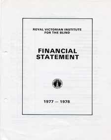 Vision Australia
Administrative record - Text, RVIB Financial Statement 1977-1978
Financial information for the Royal Victorian Institute for the Blind, presented as an appendix to the annual report of the institution.1 printed volume of financial information for the RVIBroyal victorian institute for the blind, annual reports -
 Melbourne Tram Museum
Administrative record - Correspondence, Met Tram, "Letter to all Met Tram Employees", 27/03/1997 12:00:00 AM
Photocopy of a letter, single A4 sheet - "Letter to all Met Tram Employees", signed by Russell Nathan, 27/3/1997 about the sale of Met Bus operations and discussions with PTU regarding a new EBA. Notes Footscray and Sandringham depots would be sold as part of the process.trams, tramways, ptc, met tram, unions, employees, met bus, sale of land, buses, wages -
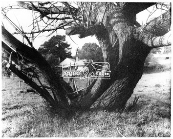 Eltham District Historical Society Inc
Negative - Photograph, George W. Bell, Gahan house, Main Road, Eltham, c.1964
View of Gahan house originally known as 'Derril' framed by an old tree. Part of a collection of photos donated by George W. Bell to the former Shire of Eltham, c.1970. In 1964 the Shire of Eltham acquired the land upon which Shillinglaw Cottage stood for the purposes of building a new Shire Office. Shillinglaw Cottage was to be demolished but a campaign was managed by the local community to save Shillinglaw Cottage which was relocated to its present day site, (Panther Place, Eltham) immediately in front of the Gahan house as viewed in the photo. The Gahan house was subsequently demolished.This photo forms part of a collection of photographs gathered by the Shire of Eltham for their centenary project book, "Pioneers and Painters: 100 years of the Shire of Eltham" by Alan Marshall (1971). The collection of over 500 images is held in partnership between Eltham District Historical Society and Yarra Plenty Regional Library (Eltham Library) and is now formally known as 'The Shire of Eltham Pioneers Photograph Collection.' It is significant in being the first community sourced collection representing the places and people of the Shire's first one hundred years.Digital image 4 x 5 inch B&W Negsepp, shire of eltham pioneers photograph collection, eltham, shillinglaw cottage, gahan, gahan house, george w. bell collection, houses, main road, panther place, significant tree -
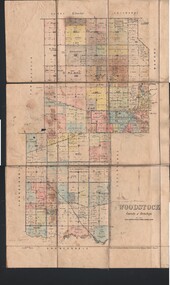 Bendigo Historical Society Inc.
Map - JACK FLYNN COLLECTION: WOODSTOCK, 4/07/1935
Map: Parish of Woodstock, County of Bendigo. Parish plan.By Authority H.J. Green. Govt Printer. Drawn and Reproduced at the Dept of Lands and Survey, Melbourne Victoria. 4.7.35map, bendigo, parish plan, woodstock -
 Ballan Shire Historical Society
Map - Map. Bungal, Department of Lands and Survey, Bungal, County of Grant, 09/09/1926
A map of Bungal in the 1920's showing the allotments, and the size, with the names of the residents. It shows the roads and the Western and Eastern Moorarbool River, and the Whipstick State Forest.Cream coloured map of Bungal in the County of Grant, bounded by the the East Moorarbool River on the East, and the State Forest on the South. It is marked with the scale of chains and the number L.358. Lithographed at the Department of Lands and Survey. Melbourne by W. J. Butson on 9.9.1926. It shows the land allotments with names of owners.Coloured pen marks and circled numbers on various areas. Price 2 shillings marked on bottom right hand edge.bungal, kerrit bareet, egerton, lal lal, borhoneyghurk, bungeeltap, ballark, yaloak, gorong, moorarbool west -
Stawell Historical Society Inc
Map, Locality Plan, Shewing Lands for Sale, 1866
Locality Plan, Shewing Lands for Sale stawell -
 Bendigo Military Museum
Administrative record - LOGBOOK, 1942 - 45
Item relates to Reginald Charles ALLARDICE No 418577 RAAF. Refer Cat No 3627.5 for his service history.Flight log book re R.C.Allardice. Book contains details re training, courses, aeroplane types flown, Training bases, flight hours. Entries are all in ink. A list at the rear shows postings that amounted to some 20 Stations.flight records, units -
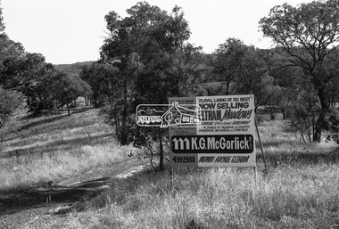 Eltham District Historical Society Inc
Negative - Photograph, Shire of Eltham, Eltham Meadows Estate, Zig Zag Road subdivision, Jan. 1980
eltham, eltham meadows estate, k.g. mcgorlick pty ltd, mcgorlick real estate, zig zag road subdivision -
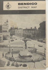 Ballarat Tramway Museum
Map, Royal Automobile Club of Victoria, "Bendigo District Map - RACV", c1971
Printed street map titled "Bendigo District Map", published by the RACV, showing the central part of Bendigo, Bendigo Outlets, streets, principal attractions, Bendigo and district maps and information, and a list of sporting and entertainment facilities. Has the tram lines shown dotted, only shows the full extent of the Golden Square line. The main map has the number "0171" in the bottom left hand corner, indicating the publication date.in ink on the Bendigo Outlet map, "3/4" along bottom edge.trams, tramways, map, bendigo, racv, railways -
Moorabbin Air Museum
Financial record (Item) - Ansett Motors Ltd Prospectus Of Issue Of 20,000 6% Preferred Ordinary Shares ........ At 1.00 Pound Each
-
 Bendigo Military Museum
Administrative record - Royal Australian Survey Corps Report on Activities - 1 Jul 1992 - 30 Jun 1994, DSvy - A, Circa 1994
Report is a summary of activities of the R0yal Australian Survey Corps Financial Years 92/9411 Pages stapled, reports and diagramsroyal australian survey corps, rasvy, fortuna, army survey regiment, army svy regt, asr -
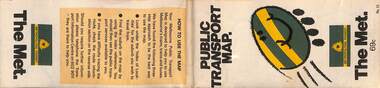 Melbourne Tram Museum
Map, The Met, "Public Transport Map - No. 13", 1984
Map No. 13 undated with the buzzing bee symbol on the front and throughout at the time of the introduction of the neighbourhoods. Includes description of tram and bus routes, private bus routes. Has contact details for bookings and lost property etc and how to use the map. Gives extensive details of the neighbourhood tickets and their used. C1984.Yields information about Melbourne public transport services in 1984.Fold out map (36 sections 9 across x 4 deep), "Public Transport Map", coloured of Melbourne's Tram and Bus routes, route numbers, rail lines, detailed for the central part of Melbourne and the outer Metropolitan services.tramways, melbourne, tram services, bus services, maps -
Glenelg Shire Council Cultural Collection
Administrative record - Ledger - Prescription Book, February 1960 - September 1961, 1960-1961
Local Chemist - Suttons, PortlandFront: n/asuttons chemist, prescriptions, ledger record, 1960s -
Bendigo Historical Society Inc.
Map - SANDHURST SHEET 5, Circa 1940's
Map: Sandhurst sheet 5. Parish plan ( number 197 in Map Cupboard 1)map, bendigo, city streets, sandhurst -
Bendigo Historical Society Inc.
Map - TARNAGULLA SHEET 2, No date visible
Map: Tarnagulla Sheet 2. Parish plan (number 307 in map cupboard 1)map, parish plan, tarnagulla