-
 Bendigo Historical Society Inc.
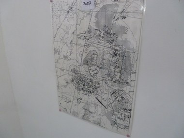
Map - BENDIGO (PART), No date visible
Map:Part of Sandhurst City streets, showing west side of High St. between Ophir St. and View Place. Parish plan.map, bendigo, city streets, bendigo city streets, sandhurst city streets -
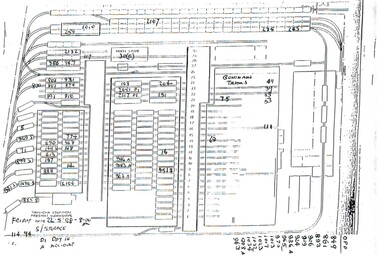 Melbourne Tram Museum
Administrative record - Depot List, Melbourne & Metropolitan Tramways Board (MMTB), "Tramcar location Preston Workshops", May. 1998
A4 photocopied sheet providing the location of tramcars at Preston Workshops, dated 22-5-1998. Has notes whether in for "day in" or "accident repairs".trams, tramways, preston workshops, lists -
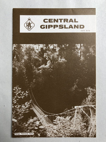 Robin Boyd Foundation
Map, RACV, Central Gippsland
walsh st library -
Bendigo Historical Society Inc.
Map - GOLDFIELD MAP
Portion of the map of the Bendigo Goldfield with the Paddy's Gully Line of Reef near the centre. Streets, contours and gullies are included. Underlined in red is the North Johnson Shaft.map, bendigo, goldfields, goldfield map, paddy's gully line of reef, north johnson shaft, mine shafts -
Whitehorse Historical Society Inc.
Map, Bruce, 1989
Map of the Commonwealth Electoral Division of BruceMap of the Commonwealth Electoral Division of BruceMap of the Commonwealth Electoral Division of Bruceelectoral boundaries, bruce (commonwealth electoral division) -
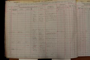 Ringwood and District Historical Society
Administrative record - Rate Books, Borough of Ringwood Valuation & Rate Book for 1924 (Assessments 1001-1160), March 2012
Originally stored at Ringwood Council offices, then taken to PROV.Only source of ratepayers in the Borough of RingwoodDigital images -
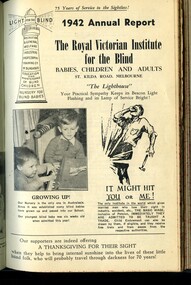 Vision Australia
Administrative record - Text, Royal Victorian Institute for the Blind annual report 1942, 1942
From it's beginning in 1867, the Royal Victorian Institute for the Blind grew in size and its number of employees and benefactors. These bound volumes of annual reports contain the information sent to subscribers of the Institute and outline the notable events and difficulties facing the blind and the RVIB. These include the acquisition of Ormond Hall, nursery and school buildings by the Commonwealth and the transferal of infants and pupils to 'The Georgian' at Olinda with the need for more staff due to more residential staff required, blind pupils formed a 'Junior Red Cross Circle' raising money and also contributed knitwear and splints for mine-sweepers, the loss of Headmaster Garnet Dent, Miss Lenna Bryson and Mrs E Dunkerton on or after the move to Olinda, the appointment of Headmaster Geoffrey E Green, Miss Betty De Huggard and Miss Dulcie Allen, with Mrs Rita Nightingall and Miss Vera Hopton visiting Olinda to provide lessons, Arthur McKay passed his Diploma of Music, 1400 pianos and harmoniums were tuned this year, as most sighted employees are engaged in war work an application was successful with the Director of Manpower to keep some sighted workers in key positions as they may be required to help those blinded by war action, around 25 partially sighted workers have been placed in other factories, several workers passed the Junior First Aid Certificate of St John's Ambulance, and the loss of Dr W.B. Vance who was Honorary Medical Officer for 39 years.1 volume bound with illustrations.royal victorian institute for the blind, annual reports -
Moorabbin Air Museum
Administrative record (item) - RAAF Wirraway Aircraft Servicing And Maintenance Form E/E.77 Travel Copy - A20-747, Royal Australian Air Force, Travel Copy: Aeroplane Maintenance Form E/E. 77, 22/08/56
Contains daily inspection and test flight records. -
Glen Eira Historical Society
Map - Victorian Railways
This file contains three items. 1. Original railways grid map of Victoria with passenger mileages (in miles) which shows railway stations in Glen Eira as part of the rail network. 2. Original pamphlet titled ‘Pocket History Vicrail 1839 – 1981’, dated 1981. Chronological history of milestones and dates, ie. 1981 Caulfield loop opened 24/01/1981 as part of underground rail loop. Image on front cover shows 2 images (steam train and stainless steel train). 3. Original pamphlet by Ministry of Transport titled ‘Your neighbourhood Public Transport System’ outlining fare structure. Stylised map of Caulfield (Glen Eira) neighbourhood.carnegie, bentleigh, caulfield, elsternwick, glenhuntly, ormond, murrumbeena, railways, public transport, bus, train, tram, railway stations, ‘vicrail’, underground rail loop -
National Vietnam Veterans Museum (NVVM)
Journal, RSL News
veterans – australia – periodicals -
 National Vietnam Veterans Museum (NVVM)
Map, Map of Area Surround Luscombe Airfield
Laminated map of military installations surrounding Luscombe Airfield. No identification of the map.luscombe field -
 Kew Historical Society Inc
Plan, Melbourne and Metropolitan Board of Works, Borough of Kew : Detail Plan No.1562, 1905
The Melbourne and Metropolitan Board of Works (MMBW) plans were produced from the 1890s to the 1950s. They were crucial to the design and development of Melbourne's sewerage and drainage system. The plans, at a scale of 40 feet to 1 inch (1:480), provide a detailed historical record of Melbourne streetscapes and environmental features. Each plan covers one or two street blocks (roughly six streets), showing details of buildings, including garden layouts and ownership boundaries, and features such as laneways, drains, bridges, parks, municipal boundaries and other prominent landmarks as they existed at the time each plan was produced. (Source: State Library of Victoria). This plan forms part of a large group of MMBW plans and maps that was donated to the Society by the Mr Poulter, City Engineer of the City of Kew in 1989. Within this collection, thirty-five hand-coloured plans, backed with linen, are of statewide significance as they include annotations that provide details of construction materials used in buildings in the first decade of the 20th century as well as additional information about land ownership and usage. The copies in the Public Record Office Victoria and the State Library of Victoria are monochrome versions which do not denote building materials so that the maps in this collection are invaluable and unique tools for researchers and heritage consultants. A number of the plans are not held in the collection of the State Library of Victoria so they have the additional attribute of rarity.Original survey plan, issued by the MMBW to a contractor with responsibility for constructing sewers in the area identified on the plan within the Borough of Kew. The plan was at some stage hand-coloured, possibly by the contractor, but more likely by officers working in the Engineering Department of the Borough and later Town, then City of Kew. The hand-coloured sections of buildings on the plan were used to denote masonry or brick constructions (pink), weatherboard constructions (yellow), and public buildings (grey). MMBW detail plan No.1562, in contrast to No.1561 includes the names of a large number of houses: in Barkers Road: ‘Ashwick’, ‘Owasso’, ‘Anadiha’, ‘Eurobin’, ‘Carlsruhe’, ‘Arlington’ and ‘Altyre’. Unnamed but clearly represented on the plan is what was then known as the ‘Auburn Heights Recreation Club’, which at this stage included a Bowling Green, a Croquet Green and two Tennis Courts. On the plan, Brougham Place, as it was then known, is represented. It was later renamed Daniell Place. The aforementioned Arlington is now the junior campus of Preshil. melbourne and metropolitan board of works, detail plans, mmbw 1562, cartography -
Bendigo Historical Society Inc.
Map - WELLSFORD, 4/07/1876
Map: Parish of Wellsford, County of Bendigo. Strathfieldsaye, Wellsford , Bagshot (number 311 in map cupboard 1)map, bendigo, parish plan, wellsford -
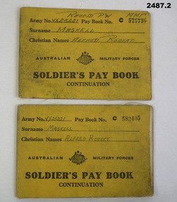 Bendigo Military Museum
Administrative record - BOOK, Soldiers pay, 22.6.40 - 12.12.45
Alfred Robert Maskell VX25221 4th Anti Tank Regt 2nd AIF. Refer 2485 medals and service history also 1076, 1100.2, 2484P..1) Pay book, yellow covers, No C575736 re VX25221 Maskell Alfred Robert, 24 pages. .2) Pay book, yellow covers, No C582405 re VX25221 Maskell Alfred Robert, 24 pages..1) "RECOVD PW AMF" (Recovered Prisoner of War)records, pay, military -
Whitehorse Historical Society Inc.
Map, State Electoral Provinces, 1978
State Electoral Provinces 1975 redivision (1977 subdivisions) Scale 1:90,0000State Electoral Provinces 1975 redivision (1977 subdivisions) Scale 1:90,0000State Electoral Provinces 1975 redivision (1977 subdivisions) Scale 1:90,0000victoria. parliament. legislative council, electoral boundaries -
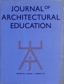 Robin Boyd Foundation
Journal, Journal of Architectural Education, Vol. 12, No.2, Summer 1957
This contains a Boyd article titled ‘These Critical Times’ p.33-36. Prof Albert Bush-Brown from MIT is the Editor of this Journal. This issue appeared the year Boyd was Bemis Professor at MIT. The same issue also has articles by Walter Gropius ('History and the Student') and Sigfried Giedion ('History and the Architect').architecture, education, walsh st library -
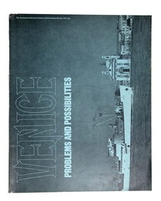 Robin Boyd Foundation
Journal, The Architectural Review, Volume 149 No 891, May-71
This issue is devoted to Venice Problems and Possibilities.architecture, walsh st library -
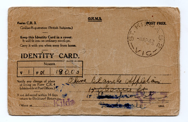 St Kilda Historical Society
Administrative record - Identification card, Identity Card, 1942
An identity card issued for civilian registration of British Subjects during World War II. This card was issued to Olive Blanche Appelton, 15 Morrie Street, Caulfield North.Brown card printed in black on both sidesPostmarked 8 April 1942 St Kilda. Card number 18003. Handwritten name, address and signatures of cardholder and witness. Handwritten additional reference numbers for official purposes.wwii, world war ii, civilian identification, id cards -
Bendigo Historical Society Inc.
Map - CAMPBELL COLLECTION: BENDIGO AND DISTRICT MAPS, 1962
Map. Mandurang, County of Bendigo. Scale 40 chains to 1 inch. Sandhurst, Strathfieldsaye, Sedgwick, Sutton Grange, Ravenswood, Lockwood, Township of Kangaroo Flat, Township of Mandurang. By Authority A.C. Brooks, Government Printer, Melbourne. Drawn and Reproduced at the Department of Lands and Survey, Melbourne,1962, Price 2/-. (number 401 in map cupboard 1)A.C. Brooks, Government Printer.map, bendigo, allotments -
Federation University Historical Collection
Plan, Ballaarat Common, 1898
Plan showing Ballaarat Common, Police Reserve, Industrial School Reserve, Cattleyards Railway, Powder Magazine, Scarsdale and Ballarat Railway, Ararat and Ballarat Railway and Mr Comries House. Robert Davidson was the surveyor. WGS 84ballaarat common, police reserve, industrial school reserve, cattleyards railway, powder magazine, scarsdale and ballarat railway, ararat and ballarat railway, comrie, ballarat common, robert davidson, ballarat industrial school -
Port Melbourne Historical & Preservation Society
Plan - Crockford Street, Ingles Street and Raglan Street, Port Melbourne, Sep 1947
Plan of area Ingles St; Crockford St and Raglan St, 1947built environment - commercial, sue pentland, william pentland -
National Vietnam Veterans Museum (NVVM)
Journal, Far Eastern Economic Review, April 11, 1975
vietnam war, 1961-1975 - participation, american -
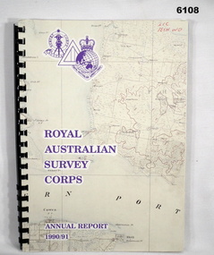 Bendigo Military Museum
Administrative record - Royal Australian Survey Corps - Annual Report 1990/91, Royal Australian Survey Corps, Late 1991
Annual Report detailing the status of Australian mapping, charting and geodesy for the period 1 Jul 90 - 30 Jun 91A4 soft covered book, glossy paper pages and plastic pockets containing maps. Plastic ring bindingTop right hand corner "2IC Tech WO"royal australian survey corps, rasvy, fortuna, army survey regiment, army svy regt, asr -
Federation University Historical Collection
Plan, University of Ballarat Camp Street Precinct, 2000, c2000
The university aspect of the Camp Street Precinct was named the arts AcademyFramed plans of the Univesity of Ballarat (later Federation University) Camp Street Precinct. .1) Drawing of elevations for the university of Ballarat and the City of Ballarat Camp Street Precinct elevations including a new performing arts Building, Mining Exchange, Visual Arts Building, and Alfred Deakin Place. .2) Camp Street Precinct elevations including the Ballarat Post Office, State Offices and Old Courthouse. camp street, camp street precinct, plans, daryl jackson, arts academy -
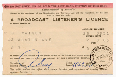 St Kilda Historical Society
Administrative record - Licence, Broadcast Listener's Licence, 1964
Authorisation to use all broadcast receivers (wireless radios) that are ordinarily kept at the address shown on the licence (including any installed in a vehicle). Licences were issued by the Postmaster General under the Commonwealth Broadcasting and Television Act. The stamp on this licence indicates that the fee was paid at Elsternwick Post Office. Separate licences were required to view television.Buff card printed in black on both sides with a red stripe along the top front edge. Date stamped in black ink, and signed in blue ink.Details of licence holder: G Watson 12 Austin Ave S3 Licence number: 15 3931 Fee: £2 15 0 Expiry: 2 8 65 Signature of issuing officer: indecipherable Time issued: 1045 am Stamped: Eltsernwick Vic 27 Au 64wireless licence, radio licence, listener's licence -
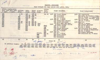 Melbourne Tram Museum
Administrative record - Reports, Melbourne & Metropolitan Tramways Board (MMTB), "Preston Workshops - Tram Summary", April 1963
Set of three Preston Workshops reports for April 1963; 1 - Preston Workshops Tram Summary - week ending 20 April 1963 - detailing the tramcars awaiting attention, lifting shop, body shop, paint shop, trams receiving attention, trams received and trams dispatched with their work done. Lists tram that are held out of service, including those sold. Has ink notes regarding cracked axles. 2 - Sheet reporting on cracked axles supplied by Thompsons in 1923 and Hadfields 3 - Axle survey - 19-4-1963 - in workshops availed for processing of in use - lists by type of gear - BTH, GE, Metro Vickers and by axle status. Has ink notes along bottom edge.Yields information about Preston Workshops reporting, axles and general management.Set of 3 typed documents - foolscap sheets.tramcars, tramways, preston workshops, tramcar maintenance, axles -
 Ballarat Heritage Services
Map, Central Europe and the Mediterranean during World War One
Map of the World as it was during World War One. map of the world, world war one, france, spain, england, ireland, germany, austria-hungary, rumania, servia, albania, greece, bulgaria, russia, asia minor, turkey, egypt, tripoli, morocco, algeria, tunis -
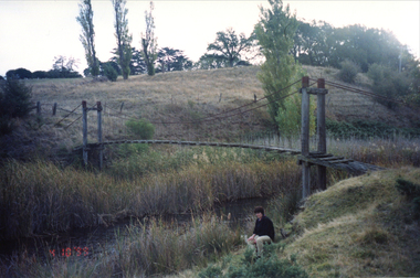 Ballarat Heritage Services
Plan - Photograph - Colour, Clare Gervasoni, Bridge at Scarsdale, Golden Plains Shire, 1999, 04/10/1999
ncil.vic.gov.au/places/67986)Colour photograph of a bridge.bridge, scarsdale -
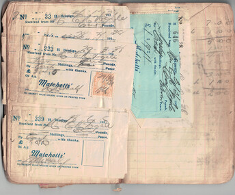 Bendigo Historical Society Inc.
Administrative record - Ledger of Groceries, 1929-1937
Initially John Matchett had a grocery store in Pall Mall. In 1893, he advertised as a hay and corn dealer. When he retired to a farm in Kamarooka, the business was taken over by his son Robert Matchett (1864-1928). In 1904 the business moved to the Corner of Mitchell St., and Bath Lane. As well as a grocers this was a wine and spirit merchant. After Robert Snr. died the shop and the liquor licence was transferred to his son Robert Jnr. (1899-1967)Joan Filbey Collection: Book - Ledger of Groceries with hand-written entries and receipts attached to some pages; entries cover 1929 to 1937history, bendigo, scouts, joan filbey collection, grocery ledger -
Federation University Historical Collection
Plan, Michael Adermann
A number of photos of Michael Adermannmichael adermann