-
 Warrnambool and District Historical Society Inc.
Journal - Diary, Diary of Augustus Bostock 1896-1904, Circa 1896
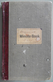
Augustus Bostock was the 9th child of Robert & Rachael Bostock of Vaucluse Epping Forest, Van Diemen’s Land. He was only 4 years old when his mother died. He was inspired by his father to seek his fortune in the Western District of Victoria. He arrived around 1850. He married Margaret Aitkin in July 1865. Augustus owned several properties in the district and leased others. He sat on the court of Warrnambool, Mortlake or Hexham as required. He resided at Marramook in Hawkesdale and later moved to Vaucluse in Hopetoun Road Warrnambool, where he died in 1920 at the age of 87. He was involved in many aspects of life in the Western District, racing, cricket, and social activities to name a few. This diary shows the daily entries over a long period of time with activities ranging from fencing, visiting neighbours and weather details. It mentions many local people and many properties he visited. Augustus Bostock along with a number of his brothers was one of the earliest pioneers in the Western District of Victoria. This diary sheds considerable light onto the life of Augustus and people of his era. There is a wealth of information on a range of topics relating to early life in Warrnambool and district.Grey cloth cover over card with maroon leather binding. Blue pages inside front and back covers. Pages are all handwritten with dates in margin. Edges of pages orange blue and yellow. Label on front cover has Minute Book printed on cream label. Marramook Diary 1896 hand written in pen. 286 pages.Marramook Sept 15th 1896 Augustus Bostock. diary of augustus bostock 1896-1904, warrnambool -
 Greensborough Historical Society
Map - Map (Copy), C. Hodgkinson, District Surveyor et al, Parish of Yan Yean 1856: Village site during construction of the Yan Yean Reservoir, 1978
Copy of map part Sec. 13, Parish of Yan Yean 1856, Map 3, Village site... Scale: 8 chains to 1 inch. Drawn by C. Hodgkinson, District Surveyor, redrawn by A. R. Blair 1978. 1 p. photocopy of map. yan yean reservoir, yan yean -
 Glenelg Shire Council Cultural Collection
Plan - Ship Plan / Mould, n.d
Wooden pattern for mould for boat fittings. Solid cylinder in two halves joined by wooden dowels. Smaller diameter cylinder attached to either end of larger cylinder. Triangular shaped 'wings' on sides of large cylinder. Painted green, inner flat sides unpainted. -
Moorabbin Air Museum
Journal - Pilot's Guide to Aerodynamics, Bradley Jones, Aerodynamics for Pilots, 09/1940
Grey softcover book.non-fiction -
Canterbury History Group
Map - Township of Canterbury and Township of Balwyn, 1900
Copies of the maps of Canterbuy and Balwyn copied and enlarged from Sands and Mcdougall Directory 1900canterbury, balwyn, sands and mcdougall directories -
National Vietnam Veterans Museum (NVVM)
Journal, Australian & NZ Defender, No. 22
vietnam war, 1961-1975 - personal narratives - australian, australia. army. royal australian regiment battalion, 7th -
 Ringwood and District Historical Society
Archive, Southwood Primary School, Ringwood Archive Collection of Photographs and Documents 1965-1997 (Parent Record)
This is the parent record of the archives collection of Southwood Primary School, Ringwood. -
Clunes Museum
Map
A MAP OF THE BOROUGH OF CLUNES. SCALE 20 CHAINS TO 1 INCH. MAIN HIGHWAYS NAMED. NO STREET NAMESdocument maps, borough of clunes map -
Port Melbourne Historical & Preservation Society
Plan - New port workers dining room and alterations, Station Pier, Port Melbourne, Godfrey, Spowers, Hughes, Mewton & Lobb, Feb 1956
Plan new port workers dining room and alterations and additions to existing offices and stores at Station Pier, 1956melbourne harbor trust - port of melbourne authority -
 University of Melbourne, Burnley Campus Archives
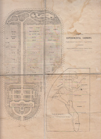
Plan, Alfred Lynch, Plan of the Experimental Gardens of the Horticultural Society of Victoria. Survey Paddock. Richmond, 1861
Subsequently the area was not fully developed in this manner following flooding in 1863. Some remnants remain.Plan on paper with cloth backing. Inscription, "Designed by Alfred Lynch. Landscape Gardener, Prahran. Printed by De Guchy & Leigh." An inset plan shows position of Experimental Gardens related to the City of Melbourne and Bay. Plan shows layout and plantings of the designated area - fruit, vegetables: the conservatory, nursery, exhibition buildings. This plan was owned by E.E. Pescott. Inscription on cover, "Burnley. E.E.P.." "Ed. E. Pescott." Subsequently the area was not developed in this manner. See inscription on copy made for Centenary Exhibition B92.633. Other copies given to College by N. Lothian (graduated 1934). Jim Sanders, a friend of his, gave them to Dr. G. Moore in 1991. A larger copy, inscribed on reverse, '1861', 'Early proposals for Horticultural Gardens for Horticultural Society of Victoria (now Royal). The lithograph was included as an insert in the Farmers Journal and Gardeners Chronicle 21 June, 1862. It is only in one of the copies held by the State Library of Victoria. 1 large and 1 small photographs of plan. Several photocopies of the plan.Inscription, "Designed by Alfred Lynch. Landscape Gardener, Prahran. Printed by De Gruchy & Leigh." / Inscription on cover, "Burnley. E.E.P.." "Ed. E. Pescott."alfred lynch, experimental gardens, conservatory, nursery, e.e. pescott, n. lothian, jim sanders, dr. g. moore, horticultural socoety of victoria -
 Ballan Shire Historical Society
Map - Map. Bungal, Department of Lands and Survey, Bungal, County of Grant, 09/09/1926
A map of Bungal in the 1920's showing the allotments, and the size, with the names of the residents. It shows the roads and the Western and Eastern Moorarbool River, and the Whipstick State Forest.Cream coloured map of Bungal in the County of Grant, bounded by the the East Moorarbool River on the East, and the State Forest on the South. It is marked with the scale of chains and the number L.358. Lithographed at the Department of Lands and Survey. Melbourne by W. J. Butson on 9.9.1926. It shows the land allotments with names of owners.Coloured pen marks and circled numbers on various areas. Price 2 shillings marked on bottom right hand edge.bungal, kerrit bareet, egerton, lal lal, borhoneyghurk, bungeeltap, ballark, yaloak, gorong, moorarbool west -
 Federation University Historical Collection
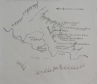
Plan, Dunn's Map of Early Gold Diggers at Golden Point, Ballarat, not dated
Hand drawn map in colour showing Yarrowee River and claims including James Oddie and Highett.dunn, dunn's map, comissioner's tent, oddie's claim, highett's claim, macdonald, suter & co claim, james oddie, golden point, gold discovery -
Stawell Historical Society Inc
Map, Shire of Stawell, Shire of Stawell Interim development Order, C 1930
Planning MapColoured Map of Stawell Shire showing Zoning AreasGuttering Haskings & Davey Pty Ltd Division of Urban and Environmental Planninglocal development -
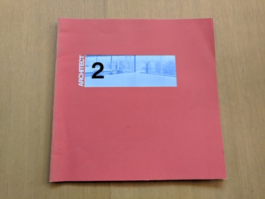 Robin Boyd Foundation
Journal, Robin Boyd et al, Architect: Issue 2, 1969
Soft Cover Magazine, Robin Boyd was the Senior Vice-Presidentarchitecture, australian architecture, walsh st library -
Stawell Historical Society Inc
Archive - Laboratory Books, Proficiency Testing
Norwellan / Aunde Now Closed Books from Dye Laboratory - Proficiency Testing North Western Woolen Mills became Norwellan Textiles then AUNDEmanufacturing -
Glenelg Shire Council Cultural Collection
Plan - Ships Plans/Moulds, n.d
Wooden pattern for mould for boat fitting. Half cylinder with rectangular section attached on angle, Smaller ½ cylinder each end. Holes on underside, to attach to other half of pattern piece. Painted brown, underside unpainted. -
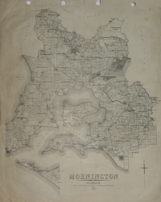 Federation University Historical Collection
Plan, Mornington, 1926
Printed plan on papermornington, phillip island, western port bay, bass straight, wonthaggi, lang lang, sherwood, nepean, narre worran, ringwood -
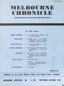 Kadimah Jewish Cultural Centre and National Library
Journal, Kadimah Jewish Cultural Centre and National Library, Melbourner Bleter / Melbourne Chronicle September 1978, ADD DATE
Journal published by the Kadimah Jewish Cultural Centre and National Library, Melbourne. Contains essays, reviews, fiction and poetry in both English and Yiddish.44 pages, A4, Softbound, Paper covers. non-fictionJournal published by the Kadimah Jewish Cultural Centre and National Library, Melbourne. Contains essays, reviews, fiction and poetry in both English and Yiddish.serge i. liberman, israel knox, prof. moshe pelli, matylda engelman, yoni ryan, juliet r. segal, yvette bentata -
Kew Historical Society Inc
Journal, The Kewriosity Sheet Vol.2 No.1 : June 1980
What's doing in Kew for June / p1. Q Crop [Youth Group, Holy Trinity Church of England Kew.] / p1. All day and long term parking for the Fenton Ave. Car Park - Kew Junction Shopping Centre / p1. Where to pick up your Kewriosity Sheet / p1. Henry Pride Volunteer Service / Mrs Jean Oswald p1. Your news is good news / p1. Kew Op Shop / p1. Do it yourself duplication [The Copy Shop] / p1. What do you do if no-one seems to have the right answer? [Citizens' Advice Bureau] p1. Kew Historical Society / p2. The friendly stranger [Stranger danger] / p2. Swimming - even in the Winter! / Maureen Meyers p2. Backgammon [Kew Backgammon Club] / p2. Diplomacy [Decision Games] / p2. 'Anything Goes [Cole Porter, Starlight Theatrical Co.] / p2. Kew Croquet Club / p2. Family tea – "Indian Style" [East Kew Baptist Church] p2. Playgroup [Uniting Church , Highbury Grove] / p2. Youth Clubs [St Hilary’s Church of England] / p2. Nominations for Council [Cr Robert Pritchard, Cr Phyllis Hore, Cr Jack Gervasoni, Cr Jack Ryan, Cr.Walter Haldun / p3. Appointment of traffic engineering consultant. [DT Grogan & Associates] / p2.The Kewriosity Sheet (1979-83) was first published in the City of Kew (Victoria) in June 1979 as a two-sided 'community newssheet'. It aimed to: 'share news about Kew happenings and Kew people, and to exchange ideas about living in Kew'. Later issues gradually evolved into a 4-page, quarto sized publication. The Kewriosity Sheet was superseded by the Kew Council publication 'Kewriosity' (1983-1994).non-fictionWhat's doing in Kew for June / p1. Q Crop [Youth Group, Holy Trinity Church of England Kew.] / p1. All day and long term parking for the Fenton Ave. Car Park - Kew Junction Shopping Centre / p1. Where to pick up your Kewriosity Sheet / p1. Henry Pride Volunteer Service / Mrs Jean Oswald p1. Your news is good news / p1. Kew Op Shop / p1. Do it yourself duplication [The Copy Shop] / p1. What do you do if no-one seems to have the right answer? [Citizens' Advice Bureau] p1. Kew Historical Society / p2. The friendly stranger [Stranger danger] / p2. Swimming - even in the Winter! / Maureen Meyers p2. Backgammon [Kew Backgammon Club] / p2. Diplomacy [Decision Games] / p2. 'Anything Goes [Cole Porter, Starlight Theatrical Co.] / p2. Kew Croquet Club / p2. Family tea – "Indian Style" [East Kew Baptist Church] p2. Playgroup [Uniting Church , Highbury Grove] / p2. Youth Clubs [St Hilary’s Church of England] / p2. Nominations for Council [Cr Robert Pritchard, Cr Phyllis Hore, Cr Jack Gervasoni, Cr Jack Ryan, Cr.Walter Haldun / p3. Appointment of traffic engineering consultant. [DT Grogan & Associates] / p2. community publications --- kew (vic.), the kewriosity sheet, newsletters - kew (vic.) -
Stawell Historical Society Inc
Archive, Stawell High School. Ex Students reunion Committee Visitors Book presented to SHS ex-Students Association, 1982 - 1987
"Visitors book. Presented to SHS Ex Students Assoc.. Signatures from booth reunuions 1982 -87.Red Covered with leather trimstawell, education -
 Kew Historical Society Inc
Plan - Subdivision Plan, Charteris Estate, East Ivanhoe, 1939
The Charteris Estate in Ivanhoe was sold in a number of sections. Copies of a subdivision plan of the first section is in the State Library of Victoria collection. This later section of the Charteris Estate includes lots in the Government Boulevard, Castella Street, McArthur Road, Burke Road North, Charteris Drive and Warncliff Road.Subdivision plans like that for the Charteris Estate are invaluable records for local historians identifying when lots in streets were promoted for sale.Four-fold brochure advertising the Charteris Estate in East Ivanhoe in 1939. Streets named on the plan include: the Government Boulevard, Castella Street, McArthur Road, Burke Road North, Charteris Drive and Warncliff Road. The brochure contains photos of Charterisville, the home of F De Castella Esq and also of attractive rolling hills. Annotations in pencilcharteris estate - east ivanhoe (vic), subdivision plans - east ivanhoe (vic) -
University of Melbourne, Burnley Campus Archives
Journal, Victorian Horticulture Digest, 1967-1970
Issued by Victorian Dept. of Agriculture. Issues: Vol. 11, No. 3 (1967, Vol. 13, No. 4 (1969-70)department of agriculture -
Stawell Historical Society Inc
Archive, Electric Supply
stawell -
Port Melbourne Historical & Preservation Society
Archive - BayLinks, Ian McKAY Archive, 1985 - 1992
These papers document Ian McKAY's involvement in the above. Filed & indexed by J BOLITHO.Ian McKAY key documents and themes - BayLinks, concept plan for Port Phillip Boulevard, info sheet from Swallow & Bain Street Residents Association, material about ESS, Port Melbourne Citizens Action Group, a response to the Bayside Development project, National Trust submissions (1985-92).public action campaigns, local government - city of port melbourne, town planning - proposals shelved - bayside, melbourne harbor trust - port of melbourne authority, ian mckay, janet bolitho -
Kew Historical Society Inc
Archive (Sub-series) - Subject File, Kew Historical Society et al, Australian Natives Association, 1958
Various partiesReference, Research, InformationSecondary Values (KHS Imposed Order)Subject file containing a single item from the former Kew Branch No 153. The file is a handbill inviting members to a branch meeting on 11 November 1907 in the Kew Town Hall. The handbill lists the names of members standing as office-bearers for the 1907-08 year. They include Messrs H Simmons, CS Clark, WJ Clark, HC Crouch, CW Ward, C Shacklock, R Church, JC Lawn, W Tredinnick, WR Church, TG Coventry, WJ Perry, H Heymanson, E Jellis, H Wentworth, CS Clark, EA Atkyns, A Cleary, H Don, L Virtue, S Abbott, T Blackburn, ? Watson, and J Gidley. The bill is annotated to show which candidates were unsuccessful. Other known members of the association include Henry Kellett.australian natives association, ana kew branch 153, mutual societies - kew (vic.)australian natives association, ana kew branch 153, mutual societies - kew (vic.) -
Bendigo Historical Society Inc.
Map - MAP: VIRGINIA MINE GARDEN GULLY LINE OF REEF
Map of Virginia Mine on the Garden Gully line of reef, Eaglehawk, transverse section. Shaft, levels and Garden Gully anticlinal axial line drawn. Key shows types of formations - quartz, spurs, sandstone, slate, cleavage, lava. This map forms part of the Geological Survey of Victoria, Structure of Bendigo Goldfield report, No. 47, 1923. H.Herman, late Director of Geological Survey.Geological Survey Victoria, Geological Survey Office, Bendigo.bendigo, gold mining, virgina mine eaglehawk, eaglehawk, bendigo, gold mining, virginia mine, garden gully line of reef. -
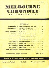 Kadimah Jewish Cultural Centre and National Library
Journal, Kadimah Jewish Cultural Centre and National Library, Melbourner Bleter / Melbourne Chronicle August/September 1983, ADD DATE
Journal published by the Kadimah Jewish Cultural Centre and National Library, Melbourne. Contains essays, reviews, fiction and poetry in both English and Yiddish.40 pages, A4, Softbound, Paper covers. non-fictionJournal published by the Kadimah Jewish Cultural Centre and National Library, Melbourne. Contains essays, reviews, fiction and poetry in both English and Yiddish.moshe ajzenbud, serge lieberman, michael liffman, annette buchbinder, j.e. shenfield, colin golvan, harry marks, alan collins, ken bandman, josie stainsby, graeme hetherington -
 Bacchus Marsh & District Historical Society
Map, Lerderderg District Proposed Irrigation and Water Supply Trust (C). Plan showing overlap in boundaries of the Trust District
The 1886 Irrigation Act in Victoria introduced the first legislation in Australia designed to enable the creation of a detailed scheme for agricultural irrigation. Part of the legislation saw the use of government funds for local irrigation projects. These local projects were managed by local irrigation trusts. The Lerderderg Irrigation and Water Supply Trust was formed in 1890. Printed paper map of the proposed Lerderderg District Irrigation and Water Supply. Plan showing overlap in boundaries of Trust District referred to in Mr Burke's report. The Lerderderg District lies within the Parishes of Korkuperrumul and Merrimu in the County of Bourke. At the top of the map above its title is the letter 'C; in capital lettering. A note on this map states: 'Portion of Bacchus MarshUrban District included in area of proposed Trust District shown by hatched shaded lines thus /////////////irrigation, water supply, lerderderg irrigation and water supply trust -
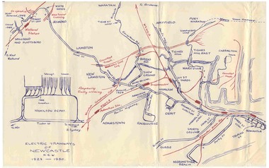 Ballarat Tramway Museum
Map, Ken McCarthy, Electric Tramways of Newcastle 1923 - 1950, c1960
Hand drawn red and blue biro map of Newcastle electric tram lines - period 1923 - 1950, showing principal railway lines, tram tracks, crossovers depot layout, level crossings on plain foolscap paper.trams, tramways, newcastle, steam trams, trams, map -
Whitehorse Historical Society Inc.
Map, Bruce, 1989
Map of the Commonwealth Electoral Division of BruceMap of the Commonwealth Electoral Division of BruceMap of the Commonwealth Electoral Division of Bruceelectoral boundaries, bruce (commonwealth electoral division)