-
 Bendigo Historical Society Inc.
Archive - MCCOLL, RANKIN AND STANISTREET COLLECTION: DEBORAH EXTENDED GMC N L - MINING BOX, 1940s
Mining box. Metal box, painted dark blue, formerly box number 476 - Now Deborah Extended Mining Box 20. Tag affixed to front 'box 476' Printed on door in white paint 'Deborah Extended'. Box contains various documents relating to Deborah Extended Mine. Documents are individually catalogued within box.mining, business, mining box 20, mccoll, rankin & stanistreet, deborah extended gmc n l, gold mining, mining box -
Stawell Historical Society Inc
Archive, Book 5. Bible Society (British & Foreign) Stawell Group. Minutes 1986 - 2002, 1986 - 2002
stawell, religion -
Port Melbourne Historical & Preservation Society
Archive - Alan Mathews and family, 7 Jul 1964
The Mathews family have been in continuous ownership of 395 Howe Parade (was 8 Howe Parade until 1964 when addresses re-assigned), Port Melbourne from 1938 to the present (Sept 2019)Six folders of assorted documents relating to the life of Alan Mathews and his family. Documents relating to the purchase of residence on Howe Parade. Building and contents Insurance from Scottish Union and National insurance Co for 395 Howe parade. (Note the changed address.)built environment - domestic, banking, utilities - water, alan mathews, j e mathews, melbourne and metropolitan board of works, mmbw -
Stawell Historical Society Inc
Archive, Stawell Business & Professional Women, Minute Books, 9/9/1968 - 3/7/1979
4 Books Various sizes etcstawell, business -
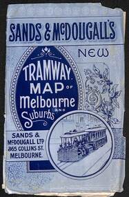 Melbourne Tram Museum
Map, Sands McDougall, "Tramway Map of Melbourne and Suburbs", c1906
Shows railways, cable and electric tram lines c1906. One of a number of maps produced by Sands McDougall of Collins St. Includes the MTOCo horse tram lines and the Caulfield horse tram lines. See items 2885 and 6573 for other editions. Yields information about Melbourne c1906 and its public transport lines. Map - folded sheet of paper 5 sections wide x 4 sections or folds deep contained within a light grey paper cover titled "Tramway Map of Melbourne and Suburbs"maps, melbourne, cable trams, tramways, railways, horse trams, nmetl, vr trams, sands mcdougall -
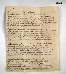 Bendigo Military Museum
literary work - POEM
Rhyming poem written by LT. John Bartlett PERRY VX 25088 2nd Light Anti Aircraft regiment. Subject is his daily task of censoring his soldiers letters. 4 pages of lined paper containing a hand written Poe o 15 paragraphs each with 6 lines. Writing in pen black ink. Stapled together with a small sewing pin. Poem signed at end with “Copyright VX 25088 J.B. PERRY”poem, censoring -
Port Melbourne Historical & Preservation Society
Archive - Alan Mathews and family, 21 May 1960
The Mathews family have been in continuous ownership of 395 Howe Parade (was 8 Howe Parade until 1964 when addresses re-assigned), Port Melbourne from 1938 to the present (Sept 2019)Six folders of assorted documents relating to the life of Alan Mathews and his family. Details of insurances and purchases Order for supply of goods on extended terms of payment. James McEwan & Co & Mr Alan Mathewsdomestic life, alan mathews -
Federation University Historical Collection
Map - Map - Geological, Kejimkujik Lake, Nova Scotia: Geological Map 94-05, 1994
Produced by Nova Scotia Department of Natural Resources, Mines and Energy Branches. The Minister of the Department was the Honourable Donald R Downe and the Deputy Minister was Darrell D HiltzLarge coloured map depicting different areas and deposits. Includes a legend, symbols used, mineral abbreviations and alteration abbreviations.Symbolskejimkujik lake, nova scotia -
Port Melbourne Historical & Preservation Society
Archive - Alan Mathews and family
The Mathews family have been in continuous ownership of 395 Howe Parade (was 8 Howe Parade until 1964 when addresses re-assigned), Port Melbourne from 1938 to the present (Sept 2019)Six folders of assorted documents relating to the life of Alan Mathews and his family. Collected items, paper notes, drawings from Alan's childhood. Nestle's Picture Album, Pictorial Atlas. Picture no 88 Rhineland castle Germanydomestic life, alan mathews -
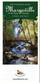 Marysville & District Historical Society
Map (Item) - Map and touring guide, Murrindindi Regional Tourism Association Inc, Marysville & The Mystic Mountains VICTORIA-AUSTRALIA, 08-2002
A fold out map and touring guide of Marysville and the surrounding district published in 2002 by Murrindindi Regional Tourism Association Inc.A fold out map and touring guide of Marysville and the surrounding district published in 2002 by Murrindindi Regional Tourism Association Inc.marysville, victoria, australia, map and touring guide, mystic mountains tourism, the beeches rainforest walk, lake mountain, cambarville, cathedral range state park, the cumberland, abbey green b&b cottages, anastasia fairytale cottage, ashlar cottage b&b, somerled mountain retreat, baree mudbrick cottages, blackwood cottages, camellia cottage, cathedral view b&b, cottage riverside, crossways country inn, dalrymples guest cottages, esa country ministries, hillcrest, keppels hotel motel, kerami house, lomatia lodge, lyell guest cottages, marylands country house, marysville caravan park, marysville holiday cottages, maryton park, melina cottage, moondai farm b&b, mountain lodge marysville, mount cathedral lodge, mystic mountains holiday cottages, nanda binya lodge, rendezvous on murchison, scenic b&b, the hermitage, tower motel, waratah house, willowbank at taggerty, woodlands of narbethong, keppels, lake mountain resort cafe, lanterns at willowbank, mantirri blueberry farm, marysville country bakery, the old woolshed cafe, clearstream olives, uncle fred & aunty val's old style lolly shop, acheron valley alpacas country store & gallery, bruno's art and sculpture garden, country touch, things of sand & stone, willowbank gallery, marysville auto & hardware, marysville newsagency & general store, marysville visitor information centre, narbethong visitor information centre, gallipoli park, keppels lookout, lady talbot drive, steavenson falls, steavenson river, taggerty river, acheron river, black spur trail riding centre, buxton trout farm, lake mountain resort ski hire, lake mountain ski school, marysville district country club, marysville ski centre, narbethong ski hire, rubicon horse riding, country touch tours, murrindindi regional tourism association inc -
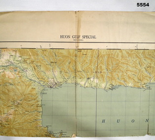 Bendigo Military Museum
Map - MAP, HUON GULF AREA, Aust Survey Corps et al, Aug 43
Refer Cat 5547 - Matheson.This is a single sided map, printed in colour. Scale 1:253,440, 4 miles to an inch, grid squares are 10mm x 10mm. Top right side shows Finschafen. Top centre is Lae, Middle is Salamau. Bottom is Lasanga Island. Top left vicinity is Nadzab and Markham River.There are four "corner" marks in pencil. Two on land and two out in the gulf.ww2, new guinea, map -
Stawell Historical Society Inc
Archive, C.W. Carter, C. W. Carter Large Shop Journal. Used by C W Carter General Store-Keeper Lamont Street. Stawell c 1937 -1963. Customer Purchase Record, 1937 - 1963
Customer Purchase Record. Large Shop Journal - Used by Mr. C.W. Carter - General Store keeper. Lamont St Stawell Phone 142Large Shop Journal Inside Cover - On Scalloped blue oval. Andrew Jack Dyson Pty. Ltd. Wholesale 54662 Stationers 596 - 610 Lonsdale Street Melbournestawell, business -
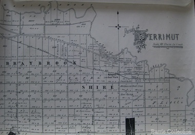 Melton City Libraries
Map, Parish of Derrimut, 1931
Map of the Parish of Derrimutcouncil -
Bendigo Historical Society Inc.
Map - HUNTLY (PART) RESURVEY, Circa 1877
Map: Huntly [part) resurvey, Parish of Huntly, County of Bendigo. Parish plan ( number 243 in Map Cupboard 1)map, bendigo, parish plan, huntly -
Whitehorse Historical Society Inc.
Map, Nunawading Map. Large Scale, 1960's?
Sheet 4 Nunawading map sections 117B -120, 125 -130 and 138B and 148. Scale 1 inch = 4 chainsSheet 4 Nunawading map sections 117B -120, 125 -130 and 138B and 148. Scale 1 inch = 4 chainsSheet 4 Nunawading map sections 117B -120, 125 -130 and 138B and 148. Scale 1 inch = 4 chainsmaps, nunawading -
 Federation University Historical Collection
Map, Lancefield, 1947
Printed coloured map on paperlancefield -
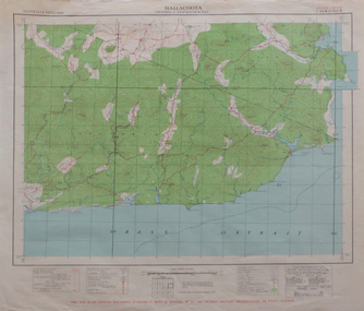 Federation University Historical Collection
Map, Mallacoota, 1942
Printed colour map on paperThis map is an official document, if found, it must be handed in to the nearest military headquarters or police stationmallacoota, bass straight, cape evarard, cann river, genoa river, disaster bay -
 Stawell Historical Society Inc
Archive, Stawell Hospital Records Board of Management Minutes 1975 – 1980. Book7, 17/12/1975 - 18/03/1980
MinutesMinute Book 7stawell health medical -
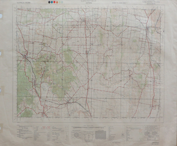
 Nhill Aviation Heritage Centre
Map - Aeronautical Maps x 9, May 1943
Typical of the maps used during navigation training here at Nhill during WW2Aeronautical maps of Victoria, Printed on light card green text and markingsThird Edition May 1943, Sheet K8, Australian Aeronautical Map, Equatorial scale 1:1000,000map, aeronaughtical map, navigation -
Port Melbourne Historical & Preservation Society
Financial record - Wage rates, Waterside Workers, 1942
Waterside Workers Wage Rate Book, 1942piers and wharves - waterside workers, percy allan may -
Stawell Historical Society Inc
Archive, Yacht Club Stawell 1955 - 1994 Prepared for 40th Anniversary, 1994
Blue Folder containing Copied Newspaper Articles 1955 - 1994stawell -
 Federation University Historical Collection
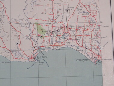
Map, Portland, 1941
Printed colour map on paperportland, port fairy, warrnambool, kirkstall, crossley, koroit, tower hill, woolsthorp -
Bendigo Historical Society Inc.
Map - HARCOURT, 2/04/1917
Map: Town of Harcourt, County of Talbot. Parish plan (number 264 in map cupboard 1)map, talbot, township, harcourt -
 Halls Gap & Grampians Historical Society
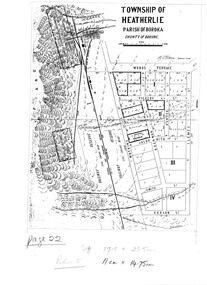
Map - Photocopy
Photocopy of map of Heatherlie TownshipTownship of Heatherlie; Parish of Boroka; County of Borung; scale measurement; R.O. Robson Authorised Surveyormaps, heatherlie township -
Kew Historical Society Inc
Archive (series) - Subject File, Liberal Party of Australia
Kew Historical Society IncSince its foundation in 1958, members of the Kew Historical Society have been compiling and storing information about subjects relating to the history of Kew and its environs, of which this file is an example. Arranged by Secondary Values (value of records to users)Subject file containing information about the Australian Liberal Party and its predecessors particularly relating to Kew. The file includes newsletters, agendas, how to vote cards, invitations to rallies etc. The information relates to three levels of government - local, state and federal.liberal party of australia -- kew (vic.), liberal and country party of victoria, political parties -- kew -- victoria -- australialiberal party of australia -- kew (vic.), liberal and country party of victoria, political parties -- kew -- victoria -- australia -
Kew Historical Society Inc
Archive (Series) - RATTEN Family
Various PartiesReference, Research, InformationArranged by Secondary Values (value of records to users)The Ratten family were an early pioneer family of the Kew area, arriving from Ireland sometime in the mid-19th century. Richard Ratten, the first of many, was a prominent Kew house builder, responsible for many of the early houses erected in Kew. He and his wife, Fanny, built and lived in the ‘Barrington’ house along Cotham Road where they would have ten children. One of his sons, Fredrick Ratten, would follow his father’s trade before taking part in local government, and serving as the Mayor of Kew in the years of 1914-1916, being known as a generous and philanthropic man. The file includes: A letter addressed to the Kew Historical society from Rosamond Barber, a descendant of the Rattens looking for information regarding her family, and an excerpt from ‘The Birds of Barrington and Beyond’, a book on the history of the Ratten family and other descendants.ratten – kew (vic.), barrington – kew (vic.), richard ratten – kew (vic.), fredrick ratten – kew (vic.), pioneers – kew (vic.)ratten – kew (vic.), barrington – kew (vic.), richard ratten – kew (vic.), fredrick ratten – kew (vic.), pioneers – kew (vic.) -
Kew Historical Society Inc
Archive (Series) - Pear Trees [Oswin Farm]
Various PartiesReference, Research, InformationArranged by Secondary Values (value of records to users)John J. Higgins, Superintendent of Parks and Gardens for the City of Kew, fought for Pear Trees marked for clearing, and argued that they were too historically significant to remove, being a part of the vegetation near the Burke Road Bridge planted by early settler Richard Oswin. The file includes: Two identical letters from John J. Higgins.pear trees – kew (vic.), john j. higgins – kew (vic.), richard oswin -- kew (vic.), kilby fram -- kew (vic.)pear trees – kew (vic.), john j. higgins – kew (vic.), richard oswin -- kew (vic.), kilby fram -- kew (vic.) -
Bendigo Historical Society Inc.
Map - BENDIGO PARISH PLAN
Bendigo Parish Plan Central Bendigo. Canvas with Canvas typed edges. Taken from George Black's maps -
Clunes Museum
Financial record - BANK RECORDS
State Savings Bank of Victoria - Clunes BranchState Savings Bank of Victoria - Progressive and Testing Statements 50A .1 June 1912-June 1922 .2 June 1923-June 1935 .3 June 1935-June 1946 .4 June 1947-June 1958 .5 June 1958-June 1962 (including General Statements) .6 June 1962-June 1966 (including Balance Sheet 1966)bank records, state savings bank of victoria -
Moorabbin Air Museum
Archive (Item) - Box Baa 20 Boeing (Gaf / Asta) Collection
Description: - JINDIVIK DRAWINGS B3B-86-433 TO B3B-86-550 Level of Importance: National. Historical Details: DAP/GAF/ASTA constructed many overseas designs under licence in Australia (Beaufort, Beaufighter, Lincoln, Canberra and F18) however they also designed and constructed a number of significant local designs that were successful in oversea's markets includi