-
 Kew Historical Society Inc
Archive (Sub-series) - Subject File, Kew Historical Society, Garbage Disposal (Kew), 1958
Various partiesReference, Research, InformationSecondary Values (KHS Imposed Order)Subject file containing primary resources/publications and newspaper articles/clippings. The oldest item in the file is a ‘Report on the Sub-Committee of the Conference of Municipalities on the Best Means of Disposing of Street and House Refuse, Street Sweepings and other Garbage of the Metropolitan Area (Brunswick, Slobom & Co., Printers, 1 Union Street, 1901). The other publication dates from 1993 and is City of Kew: Your guide to total waste management.sanitation - kew (vic), garbage - kew (vic.)sanitation - kew (vic), garbage - kew (vic.) -
Kew Historical Society Inc
Archive (collection) - Irena Higgins : Fol.13 Disability & Mental Health, 1951-2008
Irena Higgins (1951-2014) > Barbara Higgins (2015) > Kew Historical Society (2015)Professional papersCollection > Series > Sub-series (folder) > ItemThe Minus Children – Magazine | Play | Photos | Programmedepartment of health (vic.), mental hygiene authority (vic.), mental health authority (vic.), health commission of victoria, community services victoria, department of health and community services, department of human services, kew cottages, kew children’s cottages, kew training centre, kew residential servicesdepartment of health (vic.), mental hygiene authority (vic.), mental health authority (vic.), health commission of victoria, community services victoria, department of health and community services, department of human services, kew cottages, kew children’s cottages, kew training centre, kew residential services -
Stawell Historical Society Inc
Archive - Record Book, Employee Records 14/12/70 to 22/05/72
Employee Records from Norwellen Now closedCardboard oblong book stapled tape over spineEmployee Records 14/12/70 to 22/05/75 -
Kew Historical Society Inc
Archive (collection) - Irena Higgins : Fol.25 Disability & Mental Health, 1951-2008
Irena Higgins (1951-2014) > Barbara Higgins (2015) > Kew Historical Society (2015)Professional papersCollection > Series > Sub-series (folder) > ItemKew Cottages Parents’ Association {Folder 2/2] – Training centre child adoption scheme | KCPA Constitution etc.department of health (vic.), mental hygiene authority (vic.), mental health authority (vic.), health commission of victoria, community services victoria, department of health and community services, department of human services, kew cottages, kew children’s cottages, kew training centre, kew residential servicesdepartment of health (vic.), mental hygiene authority (vic.), mental health authority (vic.), health commission of victoria, community services victoria, department of health and community services, department of human services, kew cottages, kew children’s cottages, kew training centre, kew residential services -
Bendigo Historical Society Inc.
Map - HUSTLERS LINE OF REEFS - LONGITUDINAL SECTION THROUGH THE SADDLE REEFS
Drawing with Longitudinal Section through the Saddle Reefs along portion of Hustler's Line of Reefs, Bendigo. Map shows the depth of the mines, reef numbers and Datum 700 ft above sea level. North and South is also noted on the map. Map signed by H. S, Whitelaw, Underground Survey Office, Bendigo, September 1913. Bulletin No 33, Plate No XXXIV. Bendigo Creek, Ironbark Creek and Long Gully are also noted. Mines are: Fortuna Hustlers, Hustler's Royal Reserve No 2 Main Shaft, Hustler's Royal Reserve No 2 Park Shaft, Royal Hustler's, Imperial Hustler's, Extended Hustler's Freehold, Great Extended Hustler's Tribute (Pups), Old Shaft, Great Extended Hustler's Reef No 2, Great Extended Hustler's Main Shaft, Old Shaft, Hustler's Reef, Hustler's Reef No 1, Comet, K. K., United Hustler's & Redan, Old Shaft and Hustler's Consols. Has Geological Survey of Victoria Crest and underneath is: H. Herman, Director, W. Dickson, Secretary for Mines, The Hon. J Drysdale Brown M L C. Minister of Mines.Geological Survey of Victoria Crestmining, parish map, hustler's reef maps, hustlers line of reefs, bendigo creek, ironbark creek and long gully are also noted. mines are: fortuna hustlers, hustler's royal reserve no 2 main shaft, hustler's royal reserve no 2 park shaft, royal hustler's, imperial hustler's, extended hustler's freehold, great extended hustler's tribute (pups), old shaft, great extended hustler's reef no 2, great extended hustler's main shaft, old shaft, hustler's reef, hustler's reef no 1, comet, k. k., united hustler's & redan, old shaft and hustler's consols.h s whitelaw, underground survey office bendigo september 1913, bulletin no 33 plateno xxxiv, mi -
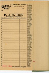 Ringwood and District Historical Society
Financial record - Order book, K & H Tibb, licenced grocers, Ringwood (Victoria) - C 1960
Grey covered book, part used, perforated original and duplicate pages, blue carbon copy sheets, preprinted shopping list down right hand side of page, cardboard backing.Page heading - Your Foodland Store, 1 Bedford Road Ringwood Phone 870-2699 (2 lines) -
Bendigo Historical Society Inc.
Archive - MCCOLL, RANKIN AND STANISTREET COLLECTION: NEW MONUMENT GOLD MINING COMPANY - MINING BOX, 1930's
Mining Box. Metal box painted dark blue with New Monument painted in white on the front. Formerly Box number 484, now Mining Box number 16. Box contains various documents relating to the New Monument mine. Documents are individually catalogued within the box.mining, mining box, mccoll, ranking & stanistreet, mccoll, rankin & stanistreet, new monument gmc n/l, gold mining, mining box -
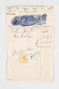 City of Greater Bendigo - Civic Collection
Financial record - Invoice, E.M Vains & Co
Ernest Morton Vains (1881 - 1951) was a local business man and Bendigo councillor who arrived in Bendigo in 1897 aged 16 from Kerang. In 1916 he founded the firm E M Vains and Co with his brother Sidney and they operated from Hargreaves Street in Bendigo with branches in Elmore, Mitiamo, Dingee, Knowsley, Heathcote and Prairie. E. M. Vains was a member of the City Council from 1922 - 1926 and was elected Mayor on August 29th, 1924. He played a prominent role in many of the City's community and industry groups and was a member of the Rotary Club which was founded in 1925 and a member of the Corona Lodge of Freemasons. Single page invoice from E.M. Vains and Co Auctioneers, Stock and Station Agents Bendigo. Letterhead features the unique R M Vains & Co logo with a bulls head, printed in royal blue ink.city of bendigo mayor, mayor vains, city of greater bendigo commerce, making a nation exhibition, mayoress vains, freemason -
 Ringwood and District Historical Society
Map - State Aerial Survey, Dandenong Ranges Area, Parts of Parishes of Nunawading, Warrandyte and Ringwood - 1956
Map of Ringwood North and parts of Mitcham, Donvale, Park Orchards and Ringwood East compiled by Dept of Lands and Survey, July 1956, from aerial photographs and Cadastral Survey information. Sheet 1, Ringwood A2D or 849 A2D Zone 7. Scale: 4 chains to 1 inch. Contour interval 20 feet. -
Bendigo Historical Society Inc.
Map - KAMAROOKA : COUNTY OF BENDIGO, 29-8-21
Map. Kamarooka, County of Bendigo, Milloo, Warragamba, Minto, Whirrakee, Tandarra, Piccaninny Creek, Dingee. By authority A.J. Mullett, Govt. Printer. Photo-Lithographed at the Department of Lands and Survey, Melbourne by W.J. Butson 29-8-21. Price 1/-. (number 63 in map cupboard 1)A.J. Mullett, Govt.Printermap, bendigo, kamarooka -
 Federation University Historical Collection
Map, Rokewood, 1937, 02/1937
printed colour map on paperrokewood, illabrook, woady yaloak river -
Stawell Historical Society Inc
Archive, WW2 Memorial Appeal, 1943
Four Folders relating to WW2 Memorial, Two Receipt Books, Three Folders Welcome Home Committeestawell, war, ww2 -
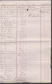 Bendigo Historical Society Inc.
Financial record - COHN BROTHERS COLLECTION: HANDWRITTEN ACCOUNTS 1891-1893
Handwritten accounts to be passed for payment with following dates. Dec 8 th 1891, Jan 12th 1892, Feb 9th 1892, March 8th 1892, April 12th 1892, May 25th 1892, June 14th 1892, July 12th 92, August 9th 1892, Sept 13th 1892, Oct 11th 1892, Nov 15th 1892, Dec 13th 1892, Jan 10th 1893, Feb 14th 1893, March 14th 1893, April 11th 1893, May 26th 1893, June 13th 1893, Aug 8th 1893, Sept 12th 1893.bendigo, industry, cohn bros brewery -
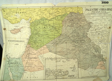 Bendigo Military Museum
Map - MAP MIDDLE EAST, Dyag Press Ltd
Coloured map of Palestine, Syria, Iraq & Crete, countries involved in the war.documents - maps, military history, middle east -
Port Melbourne Historical & Preservation Society
Archive - Alan Mathews and family, 25 Mar 1954
The Mathews family have been in continuous ownership of 395 Howe Parade (was 8 Howe Parade until 1964 when addresses re-assigned), Port Melbourne from 1938 to the present (Sept 2019)Six folders of assorted documents relating to the life of Alan Mathews and his family. Extract of birth for Jessie Maude Dwyer, 5 March 1898, Lebina, Tasmania. Parents Michael and Ellen Dwyer (Keogh)domestic life, families, alan mathews, jessie maude dwyer, michael dwyer, ellen keogh dwyer -
 Warrnambool and District Historical Society Inc.
Map - Soldier Settlement Map, Soldier Settlement Commission, Tarrone Estate Alex Boyd, 1940s
This is a map of the Tarrone Soldier Settlement land divisions probably produced by the Soldier Settlement Commission. The map is incomplete with lots 48,49 and 50 missing. The Soldier Settlement Commission purchased 23,373 acres of Tarrone Station from the Boyd brothers in 1947 and the sub divided lots were occupied by soldier settlers commencing in 1949. Tarrone Station was established in 1840 by Doctors Kilgour and Bernard and the Boyd brothers secured the free hold in the 1890s and retained it until 1947. The map hung for many years in the Warrong school near Hawkesdale.This map is of considerable interest as an original item from the establishment of the Tarrone Soldier Settlement..The map is made of brown cloth and creased. The edges are tattered and there is a piece missing at the top. It is a map of allotments, hand drawn and with faded colours in red, blue and yellow. The names of localities and land holders are hand written in ink and chalk. The map is contained within two pieces of wood at the bottom and the top. There are two screws and a cord to hang on a wall. A scale of measurement is shown under the map. tarrone soldiers settlement, boyd brothers tarrone -
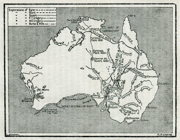 Ballarat Heritage Services
Map, Exploration of Eyre, Sturt, Stuart, Gregory, Burke, and Wills
Copy of a map from 'A Short History of Australia' by Ernest Scott.map, explorers, exploration, burke and wills, sturt, stuart, gregory, melbourne, perth, sydney, mitchell river, a.c. gregory, darling river, lachlan river, mt stuart, murray river -
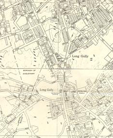 Bendigo Historical Society Inc.
Map - LONG GULLY HISTORY GROUP COLLECTION: MAP OF LONG GULLY AREA
BHS CollectionMap of Long Gully area printed on yellow paper. Map shows Eaglehawk Road from Don Street to Weatherall Street, then Mt Korong Road to Dowding Street. Some contour lines on the map.bendigo, history, long gully history group, the long gully history group - map of long gully area, borough of eaglehawk -
Stawell Historical Society Inc
Archive, Cemetery Trust Stawell. Non Purchases of Land
stawell, cemetery -
Stawell Historical Society Inc
Map, Parish of Mokepilly, County of Borung
Parish of Mokepilly, County of Borungstawell -
Stawell Historical Society Inc
Archive - Books & Papers, Stawell Rifle Club
Rifle Club existed from at least 1880's in StawellCash Books, Bank Passbooks, Loose leaf scoring sheets 1 Cash Book 1912 - 15 June 1935 2 Cash Book August 1914 9 August 1919 & meeting Minutes 1927 - 1929 3 Day Book 20 November 1946 - 30 June 1947 4 Cash Book 6 July 1964 - 29 April 1974 5 State Savings Bank Passbook 6 August 1935 - 1 June 1949 6 State Savings Bank Passbook 17 November 1937 - 12 January 1949 7 State Savings Bank passbook 26 September 1938 - 20 April 1950 8 Loose Score cards 1981 & 1984 - 1996 9 Normal Roll -
Bendigo Historical Society Inc.
Map - SNOB'S HILL - PLAN OF SNOB'S HILL AREA
Plan drawn on tracing film of sand heap, dams, trig point and mines. Some un-named streets are also drawn in. Piece of notepaper has mines drawn in on a larger scale.map, bendigo, goldfields, snob's hill, plan of snob's hill area, new st mungo mullock heap, duchess trib, s devonshire, duchess of edinburough, w u devonshire, hopewell, phoenix, unicorn, princess alice, lady barkly, sadowa, e u devonshire, united devonshire, l?, ellenborough, belmont & saxby, snob's hill -
Kew Historical Society Inc
Archive (Series) - PANTER, Alice
Various PartiesReference, Research, InformationArranged by Secondary Values (value of records to users)Baptised as Alice Seton Manifold, owned many black lace clothing, including dresses, petticoats and skirts that have been donated to the society. The file includes: Letters explaining the donation of black lace pieces to Kew Historical Society, and brief background history of Alice Panter and her husband.panter – kew (vic.), alice panter – kew (vic.), william panter – kew (vic.), alice manifold – kew (vic.)panter – kew (vic.), alice panter – kew (vic.), william panter – kew (vic.), alice manifold – kew (vic.) -
Port Melbourne Historical & Preservation Society
Archive - Alan Mathews and family, 9 Jul 1965
The Mathews family have been in continuous ownership of 395 Howe Parade (was 8 Howe Parade until 1964 when addresses re-assigned), Port Melbourne from 1938 to the present (Sept 2019)Six folders of assorted documents relating to the life of Alan Mathews and his family. Documents relating to the purchase of residence on Howe Parade. Victoria certificate of title (destroyed) of 8 Howe parade. (Presumably due to street address change)built environment - domestic, banking, alan mathews, j e mathews, state savings bank of victoria -
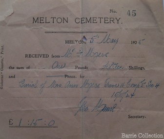 Melton City Libraries
Financial record, Melton Cemetery cheque, 1925
Ann, Henri and their sons Henry and Frederick are buried in the Melton CemeteryFor Ann Myer's buriallocal identities -
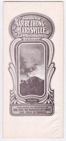 Marysville & District Historical Society
Map (Item) - Tourist Map, Department of Lands & Survey, Tourist's Map of Narbethong and Marysville Districts Victoria, 1913
A tourist map for the Narbethong and Marysville Districts that was originally produced by the Department of Lands & Survey in 1925.A tourist map for the Narbethong and Marysville Districts that was originally produced by the Department of Lands & Survey in 1925.Reprint of the 1925 Tourist brochure by permission R.E. Holmes Surveyor General By Authority: ALBERT J. MULLETT, Government Printer, Melbourne. Photo Lithographed at the Department of Lands and Survey Melbourne by W.J. Butson/ 26.8.13narbethong, marysville, victoria, department of lands & survey, the acheron valley, warburton, map, tourist map -
Bendigo Historical Society Inc.
Map - KNOWSLEY : COUNTY OF BENDIGO, 21-1-19
Map. Knowsley, County of Bendigo, County of Rodney, Weston, Crosbie, Knowsley, Dargile, Heathcote, Shingle Hut Creek, Sheep Station Creek, Forest Creek, Bendigo and Wallan Railway, Mt. Ida Creek. By authority A.J. Mullett, Government Printer, Melbourne. Photo-Lithographed at the Department of Lands and Survey, Melbourne by W.J. Butson 21-1-19, Price 1/-. (number 102 in map cupboard 1)A.J. Mullett, Government Printer, Melbourne.map, bendigo, knowsley east -
Stawell Historical Society Inc
Map, Rupunyup and Marnoo Railway Construction District 1900, 11/06/1908
Map Shows Rail Lines. Glenorchy Lubeck Rupunyup Marnoo Murtoa MinyipMap Showing line to be Constructed from Rupunyup to Newall's Corner Marnoo.Marnoo Railway Trustrailways -
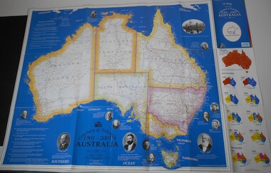 Bendigo Historical Society Inc.
Map - CENTENARY OF FEDERATION MAP OF AUSTRALIA
Map of Australia printed for the Centenary of Federation 1901-2001. Description of the footsteps to federation and starting at left pictures of: John Forrest (first premier of Western Australia) - Edmund Barton (Australia's first Prime Minister) - Charles Kingston (premier of South Australia) - Catherine Helen Spence (first woman to run for political office) - Alfred Deakin ( Australia's first deputy Prime Minister) - John Quick (Force behind the people convention) - Andrew Inglis Clark (Attorney General of Tasmania) - Henry Parkes (Premier of New South Wales) - Robert Garran (helped draft the final version of the Constitution) - George Reid (Premier of New South Wales) - Maybanke Wolstenholme (leading women' s suffrage and Federation campaigner) - Samuel Griffith (former Queensland Premier) - The Exhibition Building, Melbourne - Vaiben Louis Solomon (represented the Northern Territory). On the right the evolution of the colonies and the states from 1788 to 1915.australia, history, centenary of federation -
Kew Historical Society Inc
Archive (Series) - PURCHAS, Albert
Various PartiesReference, Research, InformationArranged by Secondary Values (value of records to users)Albert Purchas was an architect and civil engineer in the early colonial period of Victoria and was responsible for many of the early buildings both within the area of Kew, but also throughout Melbourne all the way down to Geelong. He immigrated to Australia in 1851, and would help design banks, churches, offices, and homes. He would serve for several years as the vice-President of the Victorian Institute of Architects, before being elected as President in 1887. The file includes: A recreation of a monthly meteorological journal that mentions him as a weather surveyor for Kew, as well as research notes completed by the Kew Historical Society.albert purchas – kew (vic.), architects – kew (vic.)albert purchas – kew (vic.), architects – kew (vic.)