-
 Moorabbin Air Museum
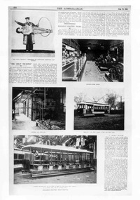
Article (Item) - Miles Falcon, Merlin & Hawk - Drawings, Articles & History, Miles Falcon VI
Miles Aircraft Company -
 Eltham District Historical Society Inc
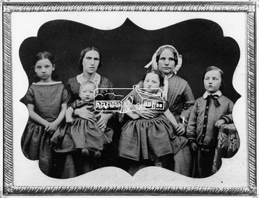
Negative - Photograph, Members of the Hill family, early Eltham settlers, c.1860
Mrs Georgina Hill (wife of Henry), nee Reynolds (of Research, Vic.) in cap [possibly misidentified by donor - see note below] with Mrs Isaac Hill and her children (left to right) Amelia Hill, (born 1853) Mrs Isaac Hill with baby Isaac (born 1860, Eltham) on her lap. Mary Jane Hill (born 1857, Eltham) seated on Mrs Henry Hill's lap and Bob Hill. The Hill family were early settlers of the Eltham area. Daguerreotype photo enclosed in a leather bound clam shell box with felt lining and gold trim. Donated by Mrs Ivy Edna Hill, 4/1 Bridge Street, Eltham, 4 June 1966 and includes copy of her note identifying the people. Daguerreotypes were one of the first forms of early photographs. They initially appeared in Europe in 1839 and were produced in large numbers to the early 1850s but were superseded by more modern and flexible forms of technology by 1860. The photo was usually formed on a thin copper plate with light sensitve silver iodide. They have a mirror-like appearance and the image itself was mirrored. They were usually inserted into a case or frame made of wood bound in leather or velvet and cost about one guinea in Australia, the equivalent of a week's wages. With the advent of the gold-rush and growing population came an increase in numbers of photographers both studio and travelling. The daguerreotype process was protected by patents and could only result in a single image from which no copies could be made. With new technology involving wet colloidion glass plate negatives and albumen paper prints of which multiple copies could be produced at significantly reduced cost, the dauguerreotype quickly fell out of favour. An accompanying note with the photo written by Edna Hill of 4/1 Bridge Street Eltham dated 4 June 1966 states: "Dear Mr Watson, I think the enclosed old time photograph will be of interest to you. It would have been taken about 1860. The two ladies are the wives of the original pioneers of the Hill family. The one in the cap was the wife of Henry Hill, the other of Isaac Hill. The children are those of Mrs Isaac Hill, and grandchildren to Henry Hill. The little girl on the left is Amelia, the baby Isaac, the second girl is Mary Jane, and the boy on the right is Bob Hill. They grew up tobe Uncles and Aunts of my late husband. I greatly appreciated a letter received a few months ago per Cr Pelling, from the Shillinglaw Cottage Committee. Yours sincerely, Edna Hill" Victorian birth registrations show Mary Jane Hill was born 1857 in Eltham (9879 / 1857) and Isaac Hill at Eltham in 1860 (1972/1860) NOTE: Mrs Isaac Hill was Ellen Fitzsimons (1834-1863), mother to Henry Hill. Mrs Georgina Hill, wife of Henry cannot be the lady in the cap as she was not born till 1864. Georgina Reynolds (1864-1927) married Henry Hill (1862-1948) in 1884. This lady has significant wrinkling of the face, especially around her mouth. It is possible that she is the mother of Mrs Isaac Hill (Ellen Fitzsimons) who was Isabella Fitzsimons (nee Ferguson).This photo forms part of a collection of photographs gathered by the Shire of Eltham for their centenary project book,"Pioneers and Painters: 100 years of the Shire of Eltham" by Alan Marshall (1971). The collection of over 500 images is held in partnership between Eltham District Historical Society and Yarra Plenty Regional Library (Eltham Library) and is now formally known as 'The Shire of Eltham Pioneers Photograph Collection.' It is significant in being the first community sourced collection representing the places and people of the Shire's first one hundred years.Digital image 4 x 5 inch B&W Negsepp, shire of eltham pioneers photograph collection, eltham, hill family, research (vic.), women, amelia hill, bob hill, daguerreotype, early settlers, georgina hill (nee reynolds), isaac hill, mary jane hill, mrs henry hill, mrs isaac hill, ellen hill (nee fitzsimons), isabella fitzsimons (nee ferguson) -
 Eltham District Historical Society Inc
Negative - Photograph, J.A. McDonald, Removal of the remains of the Abraham house at Kangaroo Ground, c. May 1962
Martin Bros House Removing of Seaford was contracted to remove the remains of the storm damaged Abraham house from the property circa May 1962. The Abraham family owned land near the Aqueduct and east of Nicholas Lane at Kangaroo Ground (based on photos, at or near 40 Nicholas Lane).Record of various Shire of Eltham infrastructure works undertaken during the period of 1952-1962 involving bridge and road reconstruction projects, sometimes with Eltham Shire Council Project Reference numbers quoted. It was during this period that a number of significant improvements were made to roads and new bridges constructed within the shire that remain in place as of present day (2022). In many situations, the photos provide a tangible visible record of infrastructure that existed throughout the early days of the Shire. The album was put together by or under the direction of the Shire Engineer, J.A. McDonald.1962-05, abraham house, kangaroo ground, martin bros house removing seaford, nicholas lane, property damage -
Whitehorse Historical Society Inc.
Article, Road Headache Removal, 2015
Work to remove Blackburn level crossing will begin in late 2015 and will be completed by 2018.Work to remove Blackburn level crossing will begin in late 2015 and will be completed by 2018.Work to remove Blackburn level crossing will begin in late 2015 and will be completed by 2018.railway crossings, blackburn -
Whitehorse Historical Society Inc.
Article, Officers reign in spending, 1994
Article about City of Nunawading's triennial budget to be adopted 3 Oct 1994 in the knowledge that the City will be amalgamated shortly.Article about City of Nunawading's triennial budget to be adopted 3 Oct 1994 in the knowledge that the City will be amalgamated shortly. Council officers have prepared it under pressure to retain their jobs.Article about City of Nunawading's triennial budget to be adopted 3 Oct 1994 in the knowledge that the City will be amalgamated shortly.local government, city of nunawading, business and finance, amalgamations -
Whitehorse Historical Society Inc.
Article, Nissan dealership closes its door, 1991
Article describing the closure of car dealerships in 1991Article describing the closure of car dealerships in 1991Article describing the closure of car dealerships in 1991brian roberts nissan, cars, ken morgan toyota, east city holden, maroondah highway, nunawading, rooks road, whitehorse road, blackburn, chapel street -
Whitehorse Historical Society Inc.
Map, Parish of Nunawading, 1970
[Parish of] Nunawading, County of Bourke. Government Printer Showing original land owners.parish of nunawading, maps, land settlement -
Canterbury History Group
Map - Maling Road Built form Map, Ciy of Boroondara, 2015
Map copied from the 'Urban Planning Special Committee Agenda' Design and Development Overlay- Schedule 23 showing heritage property on Maling Road. Produced by The City of Boroondaracanterbury, maling road, heritage buildings, city of boroondara, urban planning special committee agenda, maps -
Mission to Seafarers Victoria
Article - Survey, Bronwyn Hughes, The Art of Light: a survey of stained glass in Victoria, December 1990
Introduction Early Stained Glass in Victoria "Marvellous Melbourne" The Aftermath of the First World War Post-1945: Australian Modernism Conclusionnon-fictionIntroduction Early Stained Glass in Victoria "Marvellous Melbourne" The Aftermath of the First World War Post-1945: Australian Modernism Conclusionla trobe journal, state library of victoria, bronwyn hughes, stained glass window -
 Glen Eira Historical Society
Article - Outer Circle Linear Park
OUTER CIRCLE LINEAR PARK, joint submission by cities of Kew, Camberwell, Malvern and Caulfield. A bound fifteen page submission, dated 08/07/1985, by four councils urging the creation of the Outer Circle Linear Park. Includes map and photographs. OUTER CIRCLE RAILWAY: A PLAN FOR A LINEAR PARK, report of the Outer Circle Study Group. Bound booklet of one hundred and thirty five typewritten and photocopied pages about the creation of this park. The Introduction was signed by Tom Roper, Minister for Planning and Environment, and by Joan Kirner, Minister for Conservation, Forests and Lands. Undated but the Introduction states that public submissions must be received by 31/05/1988. Includes maps, sketches of proposed facilities, a history of the former Outer Circle Railway Line, and a description of notable plants and trees. A double sided, one page leaflet, published by the Murrumbeena Outer Circle Parkland Retention Group, MOCPRG, with timeline of the park and map. Undated but the last date on the timeline is 1985. Includes small sheet headed WHAT CAN YOU DO? Cutting from the CAULFIELD CONTACT titled A NEW PARK IT’S OFFICIAL, dated 26/02/1988, on official announcement of the new park. Two copies of OUTER CIRCLE LINEAR PARK, a four paged pamphlet published by Outer Circle Linear Park Implementation Committee on the new park. Includes detailed map. Letter between Felicitie E. Campbell of the Caulfield Historical Society, dated 14/09/1988 supporting the naming of a section of the Linear Park as Boyd Park. Two pages typed and a hand written copy. Also a type written letter from Jim Badger, Manager, Cultural Services, City of Caulfield, supporting the naming as Boyd Park, dated 16/08/1988. An album of thirty five colour photographs by Peter Foeden and Associates, of the official opening of the Outer Circle Linear Park by Premier John Cain, 1988. Photographs are numbered and the album includes handwritten descriptions of each photograph. Two mounted photographs of the Caulfield section of Linear Park, undated. One black and white and one colour.outer circle linear park, outer circle railway, parks, saunders r. e., briggs a. g., quinn m., rudski b., outer circle study group, roper tom, kirner joan, dunstan david, railways, trees, murrumbeena, campbell felicitie e., badger jim, peter foeden and associates, campbell adack, lang robert, gallney cr., cain john, cain nancy, boyd john, boyd arthur, boyd merric, boyd penleigh, boyd robyn, boyd james, boyd guy, ballantyne mr. -
Whitehorse Historical Society Inc.
Article, $5.2m boost for local schools
Mullauna Secondary College and Old Orchard Primary School will benefit from a $5.2 million grant from the State Government.Mullauna Secondary College and Old Orchard Primary School will benefit from a $5.2 million grant from the State Government. Mullauna will be able to consolidate its campus onto one site and Old Orchard Primary School to move to a larger upgraded site.Mullauna Secondary College and Old Orchard Primary School will benefit from a $5.2 million grant from the State Government.mullauna secondary college, old orchard primary school, hayward, don, pescott, roger, jaasse, kes, jobson, andrea, demorton, tracey, huynh, dattan -
Whitehorse Historical Society Inc.
Article, House of the 19th Century, 1969
An 1884 house which over the last 7 years has been lovingly restored by owner, Jeffrey Newman, is on the market.An 1884 house which over the last 7 years has been lovingly restored by owner, Jeffrey Newman, is on the market. A turn of the century photo of the house appears in the article in 'The Age'.An 1884 house which over the last 7 years has been lovingly restored by owner, Jeffrey Newman, is on the market. gordon crescent, blackburn, no. 18, newman, jeffrey -
 Eltham District Historical Society Inc
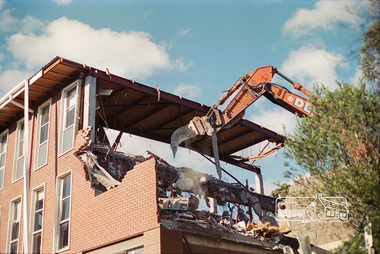
Negative - Photograph, Harry Gilham, South wing from Library drive (bluestone wall): Demolition of Eltham Shire Offices, 895 Main Road, Eltham, Aug. 1996
The Shire Offices opened in 1965 and were extended in 1971. The final Eltham Shire Council meeting was held in December 1994 before the forced amalgamations of municipal councils by the Kennett Government. The State-Government-appointed Commissioners (1994-1996) took the decision in July 1996 to demolish the Eltham Shire Offices. The demolition works started within 24 hours of the decision being made.Roll of 35mm colour negative film, 5 of 6 strips Associated printKodak Gold 100-5eltham shire office, demolition -
 Eltham District Historical Society Inc
Map (item) - Sales Brochure, Plenty Township Estate and Bryn Teg Hill's Estate, Coghill & Haughton, Melbourne, c.1924
Plenty Township Estate "The rapid growth of Greensborough and the great traffic development on the main road between Heidelberg and Eltham augurs well for Plenty Township Estate. Already a Store, Post Office and State School have been started, and the activities of the Local Progress Association will help the district forward considerably. Within walking distance of the Montmorency and Greensborough stations." Bryn Teg Hill's Estate "Better known as "The Old Sand Hill, "within walking distance of the Montmorency and Greensborough railways stations." "Some few years back Mrs Thomas subdivided portion of the Sand Hill Paddocks, and the areas sold have been settled and many converted into charming outer suburban garden homes with cultivation and orchard plots. The south-eastern slope gives the land a grand outlook over the Yarra Valley on to the Dandenoings, and the are is very picturesque and homely." "A number of the blocks contain large deposits of valuable building sand, which should prove good speculation in view of the forecast for further rapid home development along the Eltham Suburban Electric Service." Sand Hills Road (Old Eltham Road) Date estimated as c.1924 - Electricification of railway line to Eltham referenced on map occured April 1923 and Mrs Mary Thomas died August 1925. Her home Bryn Teg became part of the Heidelberg Golf Club in 1927.The establishment of Lower Plenty as a suburban growth area supported by easy commuting facilitated by the elctrification of the Eltham railway linebonds road, bridge, bryn teg hill's estate, coghill & haughton, eltham road, heidelberg golf club hotel, houses, lower plenty, lower plenty bridge, lower plenty road, main road, plenty hotel, plenty river, plenty township estate, real estate agent, sales brochure, sand hills road, the old sand hill, sand hill paddocks, woodfull road, old eltham road, bryn teg, mrs m thomas -
 Wodonga & District Historical Society Inc
Map - Tulloch & Brown's Map of the Colony of Victoria, Tulloch & Brown, 1856
The map was created by Tulloch and Brown. David Tulloch was one of the earliest engravers and lithographers in the state of Victoria. He arrived in Melbourne from Greenock, Scotland, on 3 January 1849. Following the discovery of gold Tulloch went to the Victorian goldfields in 1851, commissioned to make sketches of the diggers and the diggings for Ham’s Illustrated Australian Magazine. In November 1852 Tulloch set up in business as engraver, draughtsman, copperplate printer and lithographer. Tulloch took a map engraver, James Davie Brown, into partnership in March 1853; the several maps and specimens of commercial engraving they showed at the 1854 Melbourne Exhibition were awarded a bronze medal. That year Tulloch and Brown also received a silver medal at the Victorian Industrial Exhibition. The partnership was dissolved towards the end of 1856.This is a very early map of the Colony of Victoria including Belvoir (now know as Wodonga).A foldable map mounted on linen and with a board cover. It records the Colony of Victoria according to Surveyor's Records revised in 1857. Areas of the map are shaded to highlight different counties.At bottom right hand section of map: Tulloch & Brown's map of the Colony of Victoria : comprising part of New South Wales, the boundaries, counties, also seaport & inland townships, the gold fields with the latest discoveries, roads, tracks, &c. &c. / compiled from drawings in the Survey Office and correctly revised till 1857. Respectfully dedicated by Permission, to the Honorable Captain Andrew Clarke R.E. Surveyor General of Victoria by His Obediant Servants Tulloch & Brown, Engravers & Publishers, Melbourne". At bottom right below border : Published as the Act directs by the Proprietors, Melbourne, 1st Feb. 1856. tulloch and brown maps, rare maps victoria, victorian cartography -
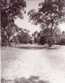
 Eltham District Historical Society Inc
Negative - Photograph, Hohne's Hill, Homestead Road, Eltham Lower Park, c.Mar. 1983
Roll of 35mm colour negative film, 4 stripsKodak Safety 5035eltham lower park, hohnes reserve, homestead road -
Canterbury History Group
Map - Elgar's Special Survey, copied 1989
Map of "Elgar's Special Survey" 8 square miles chosen by Henry Elgar in 1841, showing the location of J.B.Maling's Paddock and house, 13 acres bought in 1864.camberwell, balwyn, deepdene, canterbury, surrey hills, elgar's special survey, land subdivision, maps, maling family -
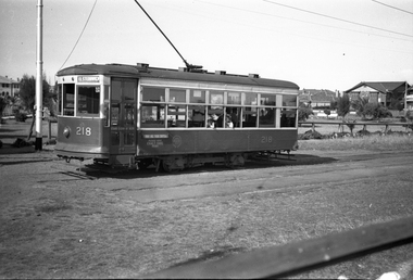 Melbourne Tram Museum
Negative, Wal Jack collection, c1940
Black and white negative by Wal Jack of X class Birney 218 at the Point Ormond terminus. Note the Pay as you enter sign, There appears to be a two many crew, the driver is chatting to the conductor in the front of the tram, with a summer jacket on. Tram has the destination of Elsternwick. Photo c1940.trams, tramways, x class, birney, point ormond, tram 218 -
Port Melbourne Historical & Preservation Society
Article, Holy Trinity "Old Boys" ordained to priesthood, 9 Dec 1972
Documentation of the celebration . Who was involved in the church at this time, any documents, key members of the church in Port MelbourneNewspaper article describing two "Old Boys" being ordained to priesthood. Mentions who attended each ceremony and where they were held.cyril letts, religion - anglican (holy trinity), kenneth letts, brian audsley, ruby letts, donald arthur langford, mrs short, mrs dillow, s stockdale, b sidwell, mrs sidwell, fred jones, mrs jones, r caton, mrs caton, robert strahan, mrs pinchin, mrs murphy, eileen hart, tessie hart, willa richardson, c stoley, l smart, t quinn, john gleeson, f a w 'skip' short -
Bendigo Historical Society Inc.
Map - BOROUGH OF EAGLEHAWK SHEET 1A, 30/11/1931
Map: Borough of Eaglehawk, Parish of Nerring. Parish plan ( number 186 in Map Cupboard 1)map, bendigo, parish plan, borough of eaglehawk, parish of nerring -
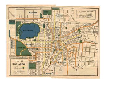 Ballarat Tramway Museum
Map, Greater Ballarat Association and George Netherway, "Map of Ballarat", c1945
Yields information about Greater Ballarat, including trams, buses, locations and streets. Has a strong association with George Netherway.Five colour map of Ballarat, showing streets, places of interest, Parks, tram routes, bus routes, railway lines, prepared by G. C. Netherway, Greater Ballarat Association, for the Victorian Government Tourist Bureau, Ballarat Branch, c1945. Shows suburbs names, location of orphanage, the lack of development north of Howitt St, in Wendouree. Map is part diagrammatic and is not entirely to scale. On rear is a road map of the Ballarat area, lists of statistics, beauty spots, look outs, art and culture, points of historical interest, industrial products and recreation. Note: Image 1, assembled from four scans, does not entirely match at edges. See Reg item 2074 for photographic image of another version map. See Reg Item 5613 for another version of this map. trams, tramways, ballarat, tram routes, bus routes, map, lists -
Glen Eira Historical Society
Article - Melbourne Aerodrome, Grange Road, Glen Huntly
Newspaper articles printed from Trove about flying at this aerodrome: 1/Two reprinted articles from the Argus, dated 12/04/1920 and 18/05/1920 respectively, detailing the series of flights given by Captain Ray King at Glenhuntly aerodrome. The first article mentions his passengers and the estimated crowd numbers who attended the event and ensuing fool hardiness of the same, who crowded the arrival and take off, of the Sopwith Gnu. The second article was published mentioning the need to regulate civil aviation and public exhibitions of flying due to the potential damage to the crowd. 2/Typed copies of these articles onto one page.larkin – sopwith aviation co of australasia ltd, caulfield racecourse, airports, racecourses, glenhuntly, glenhuntly aerodrome, king roy captain, larkin h., australian flying corps, the argus -
 Whitehorse Historical Society Inc.
Article, 22 Elder Street, Blackburn, 2017
A Blackburn home at 22 Elder Street, believed to be the first constructed in the street, will be auctioned by Woodards. The block originally sold in 1927 on which the article states eight thousand five hundred pounds which would be a typo and should read eight hundred and fifty pounds.elder street, blackburn no. 22, woodards -
 Whitehorse Historical Society Inc.
Article, Olympic Memories, June 2021
A photocopy of an article about Bob Gardiner, an ex-Olympian race walkernon-fictionA photocopy of an article about Bob Gardiner, an ex-Olympian race walkergardiner bob, walking, olympic games -
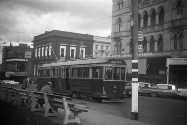 Ballarat Tramway Museum
Negative - Black and white print from negative, Travis Jeffrey, 5/09/1959 12:00:00 AM
Negative No. N392 and black and white print made by a laser printer (stored in folder) of Ballarat tram No. 40 at the City terminus in Sturt St. on the south side. Tram has the destination of Sebastopol. Has the National Mutual Life Association building in the background, the Commonwealth Bank building and Prouds Jewellers. Date of photo on folder - 5/9/1959. Original negative rescanned 24/5/2020 and image file updated.Paper folder that contained the negative had "NR6A" in red ink, "BA20" in pencil, date stamp of "5/9/1959" on front, and on rear date stamps "26 Sep 1962" and "26 Sep 1962".trams, tramways, sturt st, grenville st, signals, safeworking, tram 40 -
 Ballarat Tramway Museum
Negative - Copy, State Library of Victoria
Yields information about construction of Ballarat Tramways from a newspaper / magazine soon after the system opened, along with photographs of two of the tramcars and the power station.763 - Copy negative of page 454 of "The Australasian" paper, dated August 19, 1905, featuring an article on the opening of the Ballarat Electric Trams and magician, "The Great Thurston" Includes four photos of the trams and equipment and one of the magician. See Reg. Items No. 754, 759, and 2142. Tram photos of toastrack trams, power station, tram construction and of the single truckers in Wendouree Parade. 763.1 - print made by State Library for Alan Bradley, from Alan Bradley 5/2007. Has sticker on rear "Reproduction Rights Reserved, Copied by State Library"trams, tramways, esco, opening, ballarat, toastrack tram -
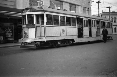 Melbourne Tram Museum
Negative, Wal Jack, c1938
Black and white negative, by Wal Jack, of W2 380 (Moreland Route 15), at the Acland St, St Kilda terminus 1938. Note the Coburg Depot Run Number. Mal Rowe advised by e-mail 21/9/20 (from the Norm Cross notes) that To commemorate 25 years of the opening of Luna Park in St. Kilda, No’s 235, 249, 303, 380, 422, 454 and 568 were painted silver with dark blue trim and suitable sign writing. Mal noted that W2 568 was given the years 1913-1938 and lights around the roof.trams, tramways, w2 class, acland st, st kilda, route 15, luna park, tram 380 -
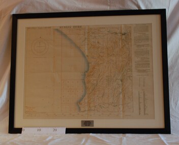 Montmorency/Eltham RSL Sub Branch
Map - Framed 1915 Anzac Cove Map, Gallipoli, 1915.ANZAC Cove Map, 1915
A framed map depicting trench lines and the battlefields of the Gallipoli Campaign, 1915, made by the Survey Department Egypt. Depth soundings of landing areas off Anzac Cove.Gallipoli - Anzac Cove World War One Map - 1915world war one, anzac, gallipoli, 1915, anzac cove, map, dardenelles, trench lines, depth soundings, landing areas -
Moorabbin Air Museum
Map (Item) - route map of Australia, ANA australian national airways
-
Port Melbourne Historical & Preservation Society
Financial record - Annual Report, Port Melbourne Bowling Club, 1911
Annual balance sheet of the Port Melbourne Bowling Club 1911-1912, 4 pgsport - lawn bowls, port melbourne bowling club