-
 Melbourne Legacy
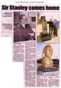
Article - Latrobe Valley Express, Sir Stanley comes home, 2006
A bronze bust was erected in Morwell to honour Legacy Founder Sir Stanley Savige. It was unveiled on 31 August 2006 and Legatee Bill Rogers was invited to perform the unveiling. The article from the local newspaper says that "Legacy founder Sir Stanley Savige was finally immortalised in his birthplace, Morwell" with the unveiling of the bronze bust. Document was from a folder of documents donated to the archive by Legatee Bill Rogers that related to his time as President (March 2006 - March 2008).A record of an memorial to Legacy founder Stanley Savige in Morwell.Photocopy of a Latrobe Valley newspaper article about the unveiling of the Stan Savige memorial in Morwell in 2006.stan savige, statue, memorial -
 Glen Eira Historical Society
Article - Koornang Road, 51, Carnegie
A colour newspaper article identified as from the Property Review Weekly and dated 22/11/02, advertising the forthcoming auction of the dwelling and shop at 51 Koornang Road on 05/12/2002. The article includes a colour photograph of the building exterior.shops, carnegie, koornang road, carnegie railway station, auctions -
Whitehorse Historical Society Inc.
Article, Petition Queen on Ayers Rock; Coombs stamp on plan for Aborigines, 14/09/1985
A new organization, One Australia Movement, led by the Aboriginal pastor, Rev Cedric Jacobs, wants to petition the Queen to stop handover of Ayers Rock to the Aborigines.A new organization, One Australia Movement, led by the Aboriginal pastor, Rev Cedric Jacobs, wants to petition the Queen to stop handover of Ayers Rock to the Aborigines. Article2. The Federal Government is considering proposals for an organization to replace the defunct National Aboriginal Congress. Changes would reflect the thrust of recommendations by Dr H.C.'Nugget' Coombs who headed an enquiry into the N.A.C.A new organization, One Australia Movement, led by the Aboriginal pastor, Rev Cedric Jacobs, wants to petition the Queen to stop handover of Ayers Rock to the Aborigines. aborigines, ayers rock, one australia movement, jacobs, cedric (rev), holding, clive, coombs, h. c. (dr), national aboriginal congress -
Glen Eira Historical Society
Article - Carnegie Methodist Church, Neerim Rd, 252- 254, Carnegie
Various Leader Newspaper articles c 2010 – 2011 on the development of the church building as a Gallery, Coffee Lounge and residence and the subsequent fire at the site.carnegie methodist church, carnegie uniting church, neerim road, toolambool road, glen eira, carnegie, breslin gallery, fine art, kay conrad, grange road, art galleries, breslin anthony, st anthony’s primary school, artists, martin scott sen det., caulfield ciu -
 City of Kingston
Map - Parish of Moorabbin
Warning: This object includes historical language referring to First Nations Peoples which is no longer appropriate but has been recorded for historical purposes. Produced in 1853, this map shows the land holdings of European families. While the majority of holdings are small there are also large land holdings as can be seen with Henry Dendy's Special Survey. Of particular note is the "Reserve for Aborigines" which was established in approximately 1841 and consisted of over 830 acres. This area is the current location of Mordialloc township and Attenborough Park, in Mordialloc, is the last remnant of the reserve. An Alfred Sikes, possibly the surveyor/cartographer who drew this parish plan, purchased land in Berwick in 1854.A handrawn map on fabric, with blue markings representing the coastline to Port Phillip Bay, red markings representing a proposed train line to Mordialloc, major roads and street, as well as a "Reserve for Aborigines", which constituted approximately 830 acres. In the bottom right hand corner, the map has been signed and dated.Handwritten in ink: Alfred Sikes / 38 Collins St East / June. 1853moorabbin, mordialloc, dendy, port phillip bay, aboriginal reserve, attenborough park -
 Whitehorse Historical Society Inc.
Article, 21 Wattle Valley Road, 2019
Demolition works of the property at 21 Wattle Valley Road, Mitcham.Demolition works of the property at 21 Wattle Valley Road, Mitcham, have begun in creating the final link between Antonio Park and Yarran Dheran Reserve.Demolition works of the property at 21 Wattle Valley Road, Mitcham.demolition site, antonio park mitcham, yarran dheran, parks and reserves, wattle valley road mitcham no21 -
 Glen Eira Historical Society
Article - Cantala
Two photocopied articles, including 3 original prints of photographs, all unattributed, about the house and property known as Cantala, owned by Septimus Miller. 1/The first article is from the Australasian newspaper, dated 18/03/1893, including two original prints (from 6 photographs in the article). The article is accompanied by one page of handwritten notes, undated and unattributed, detailing and summarising the Australasian article. 2/The second article (2 copies) is from Punch, dated 29/10/1903 and includes one original print (from 7 photographs in the article).miller septimus, salway mr, miller mrs, lauderdale mr, redleap (horse), echo (sculpture), sleeping ariadne (sculpture), cantala, caulfield, caulfield north, dandenong road, kooyong road, wiora, australasian, punch, victoria racing club, photographs, towers, italianate style, mansions, balconies, stairs, drawing rooms, bay windows, architectural features, architecutral styles, gates, gardens, stables, art, sculpture, statutes, racehorses, horses, horseracing, business people, commerce, miller helen, miller damien, garden parties, social life and customs -
Stawell Historical Society Inc
Map, Northern Grampians Shire, Town of Stawell Planning Scheme, 1981
Amendment No 21 (1981) Scale 1 : 3168 ie 4 Chains = 1 inchmining, gold -
Port Melbourne Historical & Preservation Society
Plan - Port Melbourne Town Hall, Engineering Department, Town of Port Melbourne, 1915
Plan of new (1915) Town Hall, Port Melbourne Foundation Plan, ground floor plan; first floor planport melbourne town hall -
Glenelg Shire Council Cultural Collection
Journal - Journal - Port related expenditure 1951 - 1956, c. 1951
Port of Portland collectionport of portland archives, journal -
 Whitehorse Historical Society Inc.
Legal record - Correspondence, Valuation of properties, 24/12/1929 12:00:00 AM
List of property valuations for Mitcham Riding of the Shire of Blackburn and Mitcham dated 24 / 12 / 1929.List of property valuations for Mitcham Riding of the Shire of Blackburn and Mitcham dated 24 / 12 / 1929. Valued by C. Morton of land that was being considered for parks in 1930.List of property valuations for Mitcham Riding of the Shire of Blackburn and Mitcham dated 24 / 12 / 1929. mitcham riding, mitcham road, shire of blackburn and mitcham, land values, charlesworth estate, mitcham, harrison street, burnett street, antonio, cook, w, whitehorse road, lucknow street, creek road, rooks, gell, percy street -
 Melbourne Legacy
Journal - Document, newsletter, Legacy Newsletter 1960, 1960
In 1960 the format of newsletters to widows was changing. The editor sent a notice to widows asking for their suggestions. The first newsletter in the new format (30/9/60) contains his editorial expressing disappointment that he had received no replies. There is also a letter stored with the newsletters from a widow sending her observation that the editor had sounded rejected and sends her best wishes. There is also a list of meeting dates for 1960 from 29/3/60. There were so many widows that the meetings were spread over three groups - yellow, green and red - each meeting on a different Wednesday of the month at the Melbourne Town Hall. On the free Wednesday there was a card party for anyone to attend (fee 1/-). There is a letter for October and November 1960, each of 4 pages, with details of meetings and activities such as the Christmas party. In November there were calls for nominations for the committee members in 1962. Committee comprised of a President, 2 Vice presidents, Hon. Secretary, Hon. Treasurer, Hon. Assistant Secretary and 14 members of the committee. The first edition in the new format was in 1960, previously there had been a quarterly magazine but the distribution was limited, they changed to a 4 page newsletter format to reach more of the widows. The newsletter was priced at 2c a copy. The price of theatre tickets was $3. Various pages of interest have been added to show different news items. Other editions haven't been scanned.Brings to life the activities provided for the widows and the work of Melbourne Legacy in the 1960s.Black typed newsletter x 3 editions from 1960 and associated notices from 1960. 1960 editions: 30 Sep ; 30 Oct ; 30 Novnewsletter, activities -
Whitehorse Historical Society Inc.
Article, It's only fun in the sun if you're young, 2011
Recollections about family holidays. reminiscences.Recollections about family holidays.Recollections about family holidays. reminiscences.o'neil, dave, o'neil family -
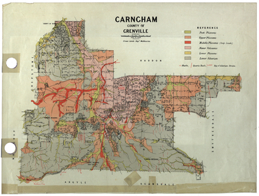 Federation University Historical Collection
Plan, Carngham, County of Grenville
A plan of Carngham, Victoria.snake valley, timber reserve, poverty point, recreation reserve, carngham, county of ripon, county of grenville, plan -
Moorabbin Air Museum
Journal (Item) - Includes articles on Concorde development of space flight, Aeronautical Journal Volume 70 Jan - Dec 1966
-
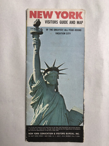 Robin Boyd Foundation
Map, New York Convention and Visitors Centre, New York Visitor Guide and Map: Of the Greatest All-Year-Round Vacation City, 1966
new york city, map, walsh st library -
Whitehorse Historical Society Inc.
Article, New Koornung City, 1994
Neighbouring cities, Box Hill, Nunawading to amalgamate under the name of Koornung.Neighbouring cities, Box Hill, Nunawading to amalgamate under the name of Koornung.Neighbouring cities, Box Hill, Nunawading to amalgamate under the name of Koornung.city of nunawading, city of box hill, city of koornung, amalgamations, local government, victoria. local government board, burke, leonie -
Whitehorse Historical Society Inc.
Article, A great lake at Blackburn's heart, 15/01/1997 12:00:00 AM
Informative article on the various recreational activities in the Blackburn Lake Sanctuary.Informative article on the various recreational activities in the Blackburn Lake Sanctuary. In 1985 a group of volunteers formed the Friends of the Lake and established an information and education centre. The program director then was Dorothy Meagher (seen in picture on right).Informative article on the various recreational activities in the Blackburn Lake Sanctuary. blackburn lake sanctuary, friends of the lake, meagher, dorothy -
Glenelg Shire Council Cultural Collection
Plan - Line drawing - Port of Portland fishing vessel, n.d
port of portland -
Whitehorse Historical Society Inc.
Map, Heritage overlay map, 1/02/1999 12:00:00 AM
City of Whitehorse heritage review : Heritage overlay map.City of Whitehorse heritage review : Heritage overlay map.City of Whitehorse heritage review : Heritage overlay map.city of whitehorse, historic buildings, blackburn, blackburn south, blackburn north, mitcham, nunawading, forest hill, vermont, vermont south, burwood east -
 Bendigo Historical Society Inc.
Negative - BENDIGO CHINESE TEA HOUSE
Construction of the Tea House, Nolan Street, Bendigo. Along side Lake Weeroona.buildings, commercial, tea house -
 Ballarat Tramway Museum
Negative - Set of 3, Campbell Duncan, 1975 or 1976
Yields information about the appearance of No. 27 and Depot Junction mid 1970's.Set of 3 selected negatives from a group of about 22 negatives showing the activities by the BTPS in Wendouree Parade c1975/1976. Photographed by Campbell Duncan (could be Paul Nicholson). .1 - No. 27 arriving at Depot Junction with destination of Carlton St and a Twin Lakes sign. .2 - ditto, picking up passengers, with Richard Gilbert driving. .3 - ditto leaving Depot Junction. trams, tramways, btps, wendouree parade, depot junction, tram 27 -
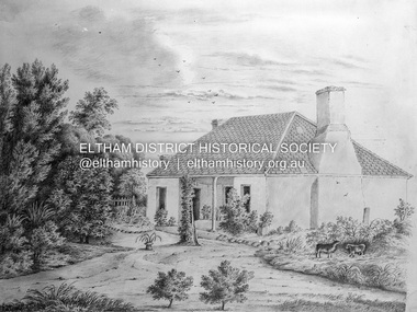 Eltham District Historical Society Inc
Negative - Photograph, Sketch; Sweeney's Cottage, Culla Hill, Eltham (n.d.), c.1970
The original sketch was photographed in 1970 for reproduction in the Shire history publication Pioneers & Painters (1971). The very fragile original was kept in the Council stoungroom and suffered significant damage to its edges over the years, no doubt it has also yellowed. A comparison of the original as digitised (2022) with the negative taken 50 years earlier also reveals that the left 20% of the sketch has been cut off, probably due to damage. In June 1842 Thomas Sweeney applied to the Superintendent, C.J. La Trobe, asking permission to purchase a portion of the recently surveyed ‘Parish of Nillumbik'. His request was allowed and handed to the sub-treasurer and Land Board. He paid £110 for 110 acres and called the land 'Culla Hill'. He first built a temporary house, a slab hut 12 feet by 10 feet, in which he lived with his wife, an Irish girl whom he had married in 1838. (His first wife had been drowned at Port Jackson.) Some time later he built a permanent residence on the model of a Tipperary farmhouse. It was a rectangular building of hand-made bricks and stone quarried from the Western Hill with a recessed verandah in front, and bore a slate roof. The out-buildings consisted of a detached kitchen, stable and a barn. It was in this house that succeeding generations of Sweeneys were reared. The original slab hut became a washhouse and survived till recent years. 'Culla Hill' became a social centre for the district, church services being held there on various occasions. The first wheat crop in the district was planted by Sweeney who also supplied the first grain for a mill that later was built at Eltham. He took an active interest in the development of the district. At this time travelling people--many of them runaway sailors or convicts--often passed the settlement, and some of them stayed and worked with Sweeney. A tribe of aborigines living on the river below 'Culla Hill' were apparently on good terms with Sweeney, for it is said that they helped him with the building of his house. Very little is known about the aborigines who originally lived in the Eltham district. There must have been many of them; their stone axes, grinding stones, and anvil stones have been found in the gullies around Research and canoe trees and artifacts were found on the Kangaroo Ground hills. Early settlers remembered a tribe that camped on the site of the present railway bridge at Eltham. They held corroborees there and visited settlers for hand-outs of 'flour and bacca’. There was an aboriginal reserve on the Yarra, upstream from Eltham, but most of those who had collected there later went to live on the Pound Reserve at Warrandyte, where the last aborigines in the area finally ended their days. The Pound Reserve, of 1,103 acres, was established at Pound Bend in 1841. The chief protector, George Robinson, and his four assistants, were given instructions to care for the aged and sick, to provide blankets and rations for all who lived there, to train the able-bodied men in agriculture and other trades and to find them jobs. The Yarra blacks, who later came under the protection of William Thomas, have been described as a 'fine race, well made and above the average height'. Thomas Sweeney died on 6 September 1867 and was buried in the Eltham Cemetery. To his wife Margaret and his son John, he left the entire property of 'Culla Hill'. To his other son Patrick, he left 150 acres, including a small two-roomed wooden cottage. He had five daughters: Kate and Margaret (twins) who were born in 1842, Ellen 1846, Annie 1848 and Johanna 1851. John Sweeney farmed 'Culla Hill' until his death in 1909. He had ten children; one of them, Mary, became Mrs M. Carrucan whose son, Mr John Carrucan, still lives at Eltham. 'Culla Hill' passed out of the Sweeneys possession in 1939 and was renamed by its new owners, 'Sweeneys', in memory of its pioneers. - Pioneers & Painters: One Hundred Years of Eltham and its Shire, Alan Marshall 1971, pp10-12 4 x 5 inch black and white negative of original colour sketchculla hill, sweeey's cottage -
National Vietnam Veterans Museum (NVVM)
Journal, DViets Newsletter
veterans – australia – periodicals, vvaa – diamond valley sub-branch -
Numurkah & District Historical Society
Journal - Art Journal
Art Journal, green cover with black floral design and gold paint -
 Federation University Historical Collection
Map, Greater Ballarat, 1968, 07/1968
Coloured street map of Greater Ballarat, including Sebastopol, and portions of the Shires of Ballarat, Buninyong, and Grenville.ballarat, map, greater ballarat association, sebstopol, canadian, eureka, alfredton, wendouree, ballarat east, mount pleasant, zilles print -
 National Vietnam Veterans Museum (NVVM)
Map, Map of Area Surround Luscombe Airfield
Laminated map of military installations surrounding Luscombe Airfield. No identification of the map.luscombe field -
 Vision Australia
Plan - Image, Proposed additional nurses bedroom to "Myer Home" existing nursery, Blind Institute, St Kilda Rd, 23/8/1949
In 1949 an architect produced this plan to detail the addition of a bedroom for the nursing staff, who looked after children in the Blind Babies nursery. The plan shows a layout of the RVIB site, including the 'Myers Home' (the name of the nursery) where young children were cared for. The south and eastern elevations are detailed, as well as a plan of the nursery, which had 4 bedrooms, a living room, a dinning room , bathroom, 2 kitchen areas and the proposed additional nurses bedroom next to Bedroom 4.1 architectural plan of Myer House and proposed extensionPercy E Everett, Chief Architectroyal victorian institute for the blind, rvib nursery, plans, myer house -
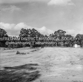 Eltham District Historical Society Inc
Negative - Photograph, J.A. McDonald, Reconstruction works, Research Oval, Jan. 1961
At commencement, looking east Early January 1961Record of various Shire of Eltham infrastructure works undertaken during the period of 1952-1962 involving bridge and road reconstruction projects, sometimes with Eltham Shire Council Project Reference numbers quoted. It was during this period that a number of significant improvements were made to roads and new bridges constructed within the shire that remain in place as of present day (2022). In many situations, the photos provide a tangible visible record of infrastructure that existed throughout the early days of the Shire. The album was put together by or under the direction of the Shire Engineer, J.A. McDonald.shire of eltham, 1961-01, infrastructure, reconstruction works, research (vic.), research oval -
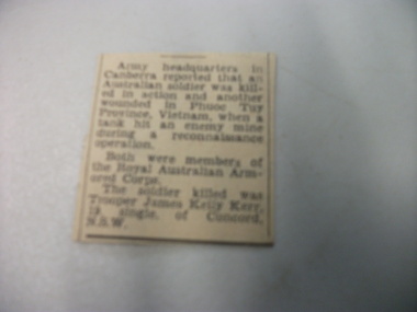 National Vietnam Veterans Museum (NVVM)
Article - Article, Clipping
A Article, Clipping from Army headquarters in Canberra reporting the death of Trooper James kelly Kerr, 19, single, of Concord N.S.W. His death happend in Phuoc Tuy Province, Vietnam. it also reports that another solder was wounded in the same accident.article, clippings, james kelly kerr, royal australian army corps, phuoc tuy province