-
 Whitehorse Historical Society Inc.
Map, Proposed Mitcham Shopping Centre, 1979
Proposed shopping complex of Mitcham.Proposed shopping complex of Mitcham - site plan and ground floor tenancy layout. Four stages of development for this shopping centre by Clarke Hopkins and Clarke Architects included.Proposed shopping complex of Mitcham.mitcham shopping centre, city of nunawading, coles supermarket, mitcham -
National Vietnam Veterans Museum (NVVM)
Journal, Frankston Vietvet
veterans – australia – periodicals, vvaa frankston & district sub-branch -
 Eltham District Historical Society Inc
Negative - Photograph, Eltham Shire Council, Unidentified road, Eltham district, c.1985
One of a series of images on roll of film shot by Eltham Shire Council officers focussing on road and street infrastructure maintenance and upgrades and new rollover kerb and channel profilesRoll of 35mm colour negative film, 4 stripsKodak CP100 5094infrastructure, road construction, road drainage, road sealing, roadworks, shire of eltham, streets, streetscape -
 Whitehorse Historical Society Inc.
Financial record, Irelands Blackburn Dairy, 1976
An invoice from Irelands Dairy to M/. Foley for house delivered milknon-fictionAn invoice from Irelands Dairy to M/. Foley for house delivered milkireland's blackburn dairy pty ltd, ireland's dairy -
National Vietnam Veterans Museum (NVVM)
Journal, Western Outpost News
veterans – australia – periodicals -
Port Melbourne Historical & Preservation Society
Financial record - Annual Report, Port Melbourne Historical and Preservation Society, Pat Grainger, Aug 2016
PMH&PS was incorporated in 1994, and from 1995 was required to hold an AGM and present an Annual Report. These were compiled, designed, printed on photocopier and bound by the Secretary, except for the Tenth anniversary edition and most recent editions, commercially photocopied.Annual report of PMHPS for 2016. Sepia coloured cover with map by Cox in 1864 reproduced2016 Annual report Port Melbourne Historical and Preservation Society (on front cover)societies clubs unions and other organisations, pmhps, port melbourne historical & preservation society, pat grainger, ann gibson, barry jones, graham bride, emma ozols nee teasdale, dan woodham, jim power, george tsingos, glen cosham, john williams, jill dawson, lex johnston, john kirby, jack bolt, suzy milburn, margaret bride, david nicholas, robyn blackmore, sue leong, david thompson, janet bolitho, steve tserkezidis, john may, sandy khazam -
National Vietnam Veterans Museum (NVVM)
Journal, Pronto: the official newsletter of the Museum Sub-Branch
veterans – australia – periodicals -
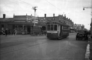 Melbourne Tram Museum
Negative, Wal Jack, c1943-44
Black and white negative, by Wal Jack, of S class 166 (showing Russell St), in Barkly St Footscray. Based on the photograph, the tram is inbound to Footscray Station, as the buildings match the current (12/2020) Google Earth view at 185 Barkly St and Albert St. In the background is - Brown's Dry cleaner, a Millinery shop at 185, W. Adler Tailor, J. Paarons PA (Radio) on the clockface and H E M Burrow? store sign. A horse drawn van is alongside the tram. Photo undated, c1943-44trams, tramways, barkly st, footscray, russell st, s class, tram 166 -
 Kew Historical Society Inc
Map, MMBW, MMBW Plan No.68 Kew, 1900-1910
The Melbourne and Metropolitan Board of Works (MMBW) was established by an act of the Victorian Parliament in 1890 to prepare for and to implement a sewerage and water reticulation system across what was then inner Melbourne, its surrounding and middle distance suburbs, including Kew. The MMBW was disbanded in 1991.The map collection of the Kew Historical Society has at its core the historic maps assembled and originally stored in the City Engineer's Department of the City of Kew. These include maps in a number of scales. The vast majority of maps were produced by the MMBW in the first two decades of the twentieth century, and are solid working maps, backed by linen for durability. These maps are historically significant to Kew, the City of Boroondara and to the history of the development of state utilities in Victoria. A number of the Kew maps have additional details added by former municipal officers, including the levels reached by various floods. As these were working documents, information was added to them long after the period of their initial production and distribution.Early map of part of the Borough of Kew, created in the first decade of the twentieth century, at a scale 160 ft to 1 inch. The map covers what was then the north central part of Kew, bordered in the north by Oak Avenue, in the west by the Yarra River and Connor's Creek, in the south by Beresford and Carnegie Avenues, and in the east by Glass's Creek and Burke Road. The map shows the extent of urban development by that time, prominent institutions and the outlines of built structures in the municipality. Contour lines and the levels of historic floods were added in ink to the map at a later stage.MELBOURNE AND METROPOLITAN BOARD OF WORKS / PLAN NO. 68 / KEW melbourne & metropolitan board of works, mmbw maps, mmbw plans, borough of kew, cartography -
Ballarat Tramway Museum
Map, Ministry of Transport, "Metropolitan Transport Services Map - Melbourne - Tram and Bus Services", c1970
Pocket size - folded - public transport map of Melbourne, printed in colours showing the bus, train and tram routes around Melbourne. Has a cover price of 10c. No printing date shown, but c1970 as distances are still in imperial, the West gate bridge is shown, though so is the Williamstown Ferry. Gives telephone numbers in 6 digit figures. Lists route numbers for trams, tramways board bus services and private services. Gives various telephone numbers for further information. Notes the map is a combined effort of the Tramways Board, Victorian Railways, Bus Proprietors' Association and the Transport Regulation Board. Single sheet of paper folded in 9 x 3 folds.trams, tramways, melbourne, map, public transport, routes -
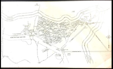 Falls Creek Historical Society
Map - Falls Creek mid 1970s
A site map produced for the Falls Creek Tourist Area Management CommitteeThis map is significant because it documents an important stage in the development of Falls Creek, Victoria.A framed and mounted site map of Falls Creek mid 1970sfalls creek tourist area management committee, falls creek tourist area, falls creek 1970s -
Whitehorse Historical Society Inc.
Journal - Committee Minutes, NHS Minutes
Legal documented minutes of the Nunawading/Whitehorse Historical SocietyCommittee minutes of Historical SocietyThese are the minutes of the Nunawading Historical Society committee meetings held in 1993committee actions and decisions, minutes -
Glenelg Shire Council Cultural Collection
Financial record - Cash Book, 1952-1953
PORT OF PORTLANDport of portland archives, cashbook -
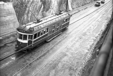 Melbourne Tram Museum
Negative, Wal Jack, c1942
Black and white negative, by Wal Jack, of W2 636 (City route 42) in the Barkers Road cutting on a wet day. In front of the tram appears to be two cars with trailers. Photo not dated in the Wal Jack album. Possibly 14-9-42 based on other similar photos.trams, tramways, barkers road, w2 class, route 42, tram 636 -
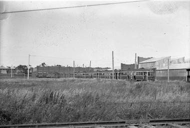 Melbourne Tram Museum
Negative - Set of 2, Wal Jack, 13/10/1940 12:00:00 AM
Set of two Black and white negatives by Wal Jack of: .1 - C class C28, E43, P136, P134, U211, U209 and No. 11 - dated 13-10-1940. .2 - Photo of the first three cars in the line. The car numbers were detailed in the album held by the Ballarat Tramway Museum. Note the bus body against the brick wall of the workshops and two former grip cars in the view. See Reg Item 5290 for details of the bus body.trams, tramways, preston workshops, u class, c class, n class, e class, p class, stored trams, buses, grip tram, tram 28, tram 43, tram 136, tram 134, tram 211, tram 209, tram 11 -
Whitehorse Historical Society Inc.
Journal - Committee Minutes, NHS Minutes
Legal documented minutes of the Nunawading/Whitehorse Historical SocietyCommittee minutes of Historical SocietyThese are the minutes of the Nunawading Historical Society committee meetings held in 2002 committee actions and decisions, minutes -
Port Melbourne Historical & Preservation Society
Map - Photographic copy, Unidentified map of Sandridge, c. 1866
Photographic copy of an unidentified (Cox?) Sandridge map 1866 or later, with portions of West Melbourne, Emerald Hill and the Bend. Indicates bay and river soundings 'taken by Commander COX in 1866'. Original appears to have been torn and repaired; resultant lines whited out on copy.Fold lines have been whited out on back; '52'piers and wharves, transport - railways, built environment, maritime, beacons, sandridge lagoon, batteries - defensive, commander cox -
Glen Eira Historical Society
Map - a'Beckett Street, 11, East St Kilda
Print of a Google map of 11 a’Becket Street, East St Kilda downloaded & printed on November 26, 2010 by Sud Abbas (role unknown). Detail shows that the address is now a car parka’beckett street, east st kilda, car parks, streetscapes, aerial photographs -
 Melbourne Tram Museum
Negative, Wal Jack, 1938
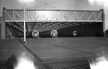
Black and white negative, by Wal Jack, of the front of Brunswick Depot, during 1938; Trams (left to right) W5 772, 767, 771, C class 30, Q class 200. Dated in album as 1938.trams, tramways, brunswick, c class, w5 class, q class, brunswick depot, tram 772, tram 767, tram 771, tram 30, tram 200 -
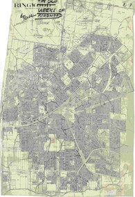 Ringwood and District Historical Society
Map, Old Creeks of Ringwood
A0-size (approx) City Engineer's map with hand-drawn overlay highlighting natural water-courses in the Ringwood area, as identified by Rob Atkins, former RDHS President. Other pencilled markings include Perry's Hut, Jull's Store, Crawley's Hut.Scale: 8 chains to 1 inch. -
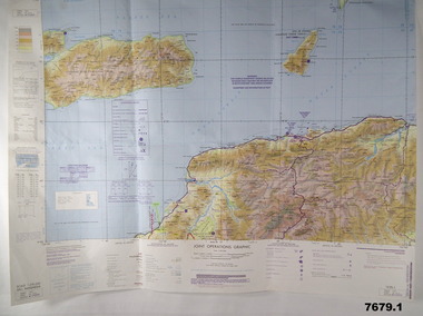
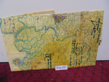 National Vietnam Veterans Museum (NVVM)
Map
A large laminated coloured map of Joint Operations Graphic (ground), Vietnam. there are specific information highlighted in pen.3rar, mcphail collection, map -
 Ballarat Tramway Museum
Negative, Geoff Grant, 8/05/1954 12:00:00 AM
Negative No. 274 and colour print made by colour laser printer (stored in folder ) of Melbourne PCC tram 980, in Coldblo Road , Malvern depot, during an AETA tour on 8/5/1954. Photo by Geoff Grant. Envelope with negative describes the scene as "980 PCC type tram. Side on view of this tram on a special AETA tour to Footscray for opening of new branch to that suburb. At Malvern depot May 8, 1954." Hi res scan of negative and image updated 19/5/2020.trams, tramways, malvern depot, pcc, coldblo road, footscray, tram 980 -
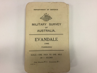 The 5th/6th Battalion Royal Victoria Regiment Historical Collection
Map, Military Survey of Australia. Evandale (1939) (Tasmania), 1939
Fabric backed colour map, with card cover that folds into a small book. Scale one inch= one mile.military, survey, map, tasmania, ww2, wark vc club -
Bendigo Historical Society Inc.
Map - TARNAGULLA : COUNTY OF BENDIGO, 1959
Map. Tarnagulla, County of Bendigo, County of Gladstone, Inglewood, Glenalbyn, Kingower, Moliagul, Painswick, Waanyarra, Laanecoorie, Woodstock, Derby, Loddon River, Dunolly to Inglewood Railway, Laurie Railway Station, Township of Tarnagulla, Tarnagulla Rifle Range, Township of Llanelly, Arnold Railway Station, Bullabul Creek, Kangderaar Creek, Township of Newbridge. By authority A.C. Brooks, Government Printer, Melbourne. Drawn and reproduced at the Department of Lands and Survey, Melbourne, 1959. (number 117 in map cupboard 1)A.C. Brooks, Government Printer, Melbourne.map, bendigo, tarnagulla -
 Bendigo Military Museum
Map - MAPS, EAST TIMOR, US Govt et al, 1975 - 1976
1. This is a coloured map. It's scale is 1.250,000 - called a jpoint operations graphic. It covers the North side of East Timor. Dili is in the centre. Its shows 4 Islands to the north of Timor. It shows Savu Fea, Ombai Strait, Wetar Strait. On bottom left of map it shows Batheade and the start of the New Border. Map - Series 159. Sheet 5C- 51-4. Edition 3-GSGS. 2. This is a coloured map. Its scale is 1.250,000 called a joint Operations Graphic. It manly covers West Timor. It shows Savu Sea in North and Timor Sea on south side. Series 1501. Sheet SC 51.7. Edition 3-GSGS. 3. This a coloured map. It's scale is 1.250,000. Joint operations graphic. This map shows the south side of East Timor and the Timor Sea. This map shows a highlighted New border. The major towns on South coast are KAMFNASA, BETANO. Map series 1501. Sheet SC 51-8. Edition 3 GSGS.1. Has highlighted "7 BSG" on coast. All maps show East Timor border highlighted in pink.east timor, maps, interfet -
Glenelg Shire Council Cultural Collection
Journal - Scrapbook, c. 1879
Scrapbook, hard cover, brown, gold 'Album' on cover. Gold edging on pages. Pages different colours. Includes hand written writings and verses, pasted scraps and number of loose items (see 10490 -10507)Front: Flyleaf - 'To Jane, with the love of her sister, Jessie Robertson, Hamilton, Feb 19th 1879' - handwritten, black ink Back: Inside back cover: drawing of a horse. 'Arab Pasha 12/11/82 Drawing MP' -
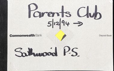 Ringwood and District Historical Society
Financial record, Southwood Primary School, Parents Financial Records
Parents Club cheque books, bank statements and receipts, and Mother's Club Account book. -
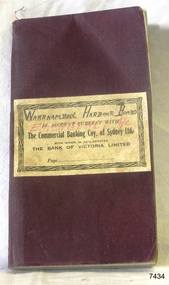 Flagstaff Hill Maritime Museum and Village
Financial record - Bank Transaction Book, Commercial Banking Company of Sydney Limited, before 1931
The financial account book was used by the Warrnambool Harbour Board for its Emergency Account. It records transactions made with The Warrnambool branch of the Commercial Banking Company of Sydney Limited during the year 1931. The Secretary of the Warrnambool Harbour Board would have used this book in 1931. James Menzies, Pilot arid Harbour Master from 1929, was appointed as Acting Secretary for the Board in 1932 and held this office until the Board ceased in 1936. Warrnambool’s CBC Manager during this time was L E Whitney; he was Manager from 1924 to 1939. The Commercial Banking Company of Sydney Limited opened in 1893. On January 1, 1927 the CBC amalgamated with the Bank of Victoria. In 1981 the CBC merged with the National Bank of Australasia Limited and on January 1, 1983 the bank started using the abbreviated name of the National Australia Bank (NAB). Warrnambool Harbour Board- The Warrnambool Harbour Board was constituted by Order of Council on May 29, 1928, under the Harbour Board’s Act of 1927, taking over from the Ports and Harbours Branch of the Public Works Department of Victoria. The Board was then the only body with power to manage and control the whole Port, including shipping, facilities upkeep and improvements of the port. The work it carried out involved dredging, building of port facilities and drafting of port regulations, and collecting taxes, tolls, rates and charges. The Board was officially dissolved on June 30, 1936, at which time the Public Works Department again had control. The Warrnambool Harbour Board had rented out the Lighthouse Keeper’s Quarters from the 1920s until 1936, when the Board closed down. However, rentals continued with other currently unknown landlords until Flagstaff Hill Maritime Village opened in 1975 and began renovating the Cottage, in stages. Text on the fly page of the book is as follows – “The Commercial Banking Company of Sydney Limited with which is Amalgamated THE BANK OF VICTORIA LIMITED. Head Office – SYDNEY. Melbourne Office: 237 COLLINS STREET. BANKING Business of every description transacted. BRANCHES throughout VICTORIA, NEW SOUTH WALES and QUEENSLAND, and ADELAIDE BRANCH, SOUTH AUSTRALIA, and AGENCIES throughout AUSTRALASIA and NEW ZEALAND on which DRAFTS AND LETTERS OF CREDIT Are issued and also on LONDON BRANCH and AGENCIES in all the PRINCIPAL CITIES of the world. Telegraphic Remittances made, Bills Negotiated or Forwarded for Collection, Advances made, Deposits received, Current Accounts kept. FURTHER PARTICULARS ON APPLICATON. “ This bank transaction book is of local and state significance for its association with the Port of Warrnambool and the Warrnambool Harbour Board. The Warrnambool Harbour Board was the only board formed under the 1927 Harbour Boards Acts, even though other Victorian ports were eligible. The book is also significant as an example of bank records used by Australian and overseas branches of the Commercial Banking Company of Sydney Limited, and the Bank of Victoria Limited.Maroon coloured rectangular book with textured cover and cream coloured label attached. Label has a printed title on book plus hand written titles added in black and red. The corners of the book are rounded. The white pages have pre-printed text and lines. The book was used for transactions between the Warrnambool Harbour Board’s Emergency Account and the Commercial Banking Company of Sydney Limited during the year 1931.Handwritten in black “WARRNAMBOOL HARBOUR BOARD “, “EMERGENCY A/C” Printed in black “IN ACCOUNT CURRENT WITH”, “The Commercial Banking Coy. Of Sydney Ltd.”, “WITH WHICH IS AMALGAMATED”, “THE BANK OF VICTORIA LIMITED”, “Page …”warrnambool, shipwrecked-coast, flagstaff-hill, flagstaff-hill-maritime-museum, maritime-museum, shipwreck-coast, flagstaff-hill-maritime-village, warrnambool harbour board, financial account, emergency account, financial record, commercial banking company of sydney limited, 1931 bank book, bank of victoria limited, transaction book, financial management, stationery, deposit book, public works department, ports and harbours, commercial banking company of sydney ltd., james menzies, harbour master, l e whitney, cbc manager warrnambool, harbour board act, port of warrnambool, warrnambool harbour, lady bay, harbour pilot -
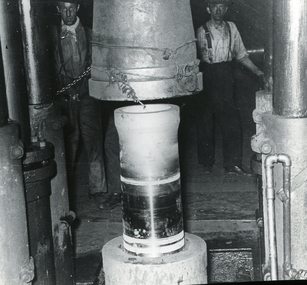 Bendigo Historical Society Inc.
Negative - Bendigo Munitions Factory (ADI) Glass Slides, Australian Defence Industries (Now THALES AUSTRALIA), c1944
The Bendigo Ordnance Factory began operating in 1942, producing heavy artillery and naval guns. In the late 1990s the then Federal Government-owned facility was sold to the multinational Thales, which continues to operate the factory today. This Bendigo Historical Society collection of glass negatives includes some slides of women working in the munitions factory. Seven slides were included in an album that was prepared for Dr Edith Summerskill who visited Australia in 1944 as part of an Empire Parliamentary Delegation. The album included photographs of Australian women working at the factory during WW2. A copy of the album is in the Collection of the Australian War Memorial.Box 3 of 3, Glass Slide Negatives of the Bendigo Munitions Factory, later known as the Ordnance Factory and then the Australian Defence Industries. Each negative is sealed between two pieces of glass. The edges are sealed with thin pieces of tape. The slides are contained in three wooden boxes with hinged lids and grooves (slots) to house them.history, bendigo, bendigo munitions factory, bendigo ordnance, bendigo adi, doctor edith summerskill, ww2, slide box 1 10165, slide box 2 10166, slide box 3 10167 -
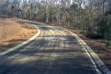
 Eltham District Historical Society Inc
Negative - Photograph, Cottlesbridge-Strathewen Road, Strathewen, c.Nov. 1987
Photos taken during a review of road and bridge/culvert condition by Eltham Shire Council engineers. A number of the trees were badly burnt or destroyed in the Black Saturday bushfire, 7 Feb. 2009 but some remained standing and identifiable as of 2014 (Google Streetview).Roll of 35mm colour negative film, 4 stripsKodak GB 200 5096bridge, chads creek, chads creek road, cottlesbridge-strathewen road, culvert, infrastructure, roads, school ridge road, strathewen