-
 Federation University Historical Collection
Map - Framed image, Public Record Office Victoria, Eureka Treason Trial Map (printed copy), 1855
The persecution produced the original of this map as an exhibit for the Treason Trials of thirteen of the Eureka Stockade in Melbourne in 1855. Witnesses at the time accepted that the map showed the location of the stockade at Ballarat and the route taken by the military and police when the stockade was attacked on 03 December 1854. The original of this work is held by the Public Record Office Victoria.Printed copy of the plan used at the Eureka Treason Trials in 1855.eureka stockade, treason trial map, ballarat, lydiard street north, camp street, paroompi, yarrowee creek -
 Melbourne Tram Museum
Map, "Tramway Map of Melbourne and Suburbs", c1952
Map of Melbourne's Tram and Bus routes, route destinations, MMTB Guest houses, all-night bus routes, depots, golf links and sporting grounds, rail lines, and location of major places of interest. Titled - "Tramway Map of Melbourne and Suburbs" - c1952, after the La Trobe or Latrobe St lines opened. Not known who produced the map. Does not give route numbers. See also Reg Item 2300 for an MMTB Map of the same era, 7315 for a similar version but without the guest houses, and 4525.1 for an MMTB Photograph.Yields information about Melbourne tram routes prior to Bourke St being built.Fold out map (6 sections), two colours. Has been removed from a book with the remnants of other paper in the top left-hand side.trams, tramways, melbourne, map, tram & bus services, all night services, mmtb, guest houses -
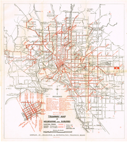
 Melbourne Tram Museum
Map, The Met, "Public Transport Map of Melbourne", June 1992
Map - 36 fold - 9 x 2 x 2- colour map of public transport including buses, titled "Public Transport Map of Melbourne", published by the Public Transport Corporation, Effective June 1992. Gives rail and tram maps, information on tickets. Has The Met contact details. 2 copies held .1 - as above but a 6 fold DL, dated Jan 8, 1995trams, tramways, map, ptc, melbourne, the met -
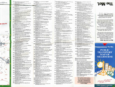
 Bendigo Historical Society Inc.
Financial record - Abbott Collection: Invoice
An invoice from Ullathorne & Co. leather, shoe mercery, grindery & general merchants dated June 30th 189? issued to Messrs. Abbott & Co. for a total of 13 pounds 6 shillings 9 pennies.invoice, abbott, business -
Whitehorse Historical Society Inc.
Map, Canterbury Road, Blackburn, 1972
Enlarged aerial photograph of area around the intersection of Canterbury and Middleborough Roads, Blackburn.Enlarged aerial photograph of area around the intersection of Canterbury and Middleborough Roads, Blackburn.Enlarged aerial photograph of area around the intersection of Canterbury and Middleborough Roads, Blackburn.canterbury road, blackburn, middleborough road, blackburn, box hill, craig street, blackburn, hirst street, blackburn, aerial photographs -
Glenelg Shire Council Cultural Collection
Map - Map -Port of Portland Photocopy, n.d
Port of Portland Authority Archivesport of portland archives -
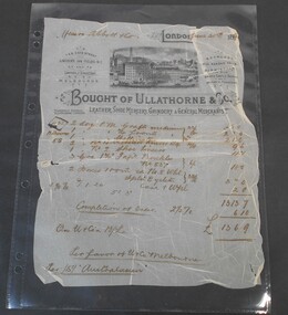
 Melbourne Tram Museum
Map, Russell J. Nowell, "The Melbourne Tramway System", mid 1960's
Printed map (dye line process) on a large sheet of paper contained within an envelope. .1 - Brown paper envelope with a printed sheet glued to the envelope - giving title "The Melbourne Tramway System", publisher ("Unitrans - Universal Transport Research and Planning Services" - with a space for the retail price. .2 - Map printed on paper and folded into 16 parts - details the track layouts for routes and depot, route numbers, sections, Latrobe and William St services and details of fares. Has a sketch of tram 980 in the top right hand corner along with details of the tram system. Also includes depot locations, reserved tracks and derails at level crossings, though railway level crossings are not shown. Produced by Russell J. Nowell - gives address and phone number along with the "UniTrans" logo. Advised by other members, he was a Tasmanian. Not dated, but appears to be mid 1960's. Plan scanned 1-3-2016 as a tiff file.Envelope has the name and address of the donor "Brian Weedon 5/124 Alexandra St East St Kilda"trams, tramways, map, mmtb, depots, tram routes, trackwork -
Whitehorse Historical Society Inc.
Map, Springfield Road, Blackburn, 1924
Plan of subdivision, parts of Crown Portions 73 and 74, parish of Nunawading, County of Bourke.Plan of subdivision, parts of Crown Portions 73 and 74, parish of Nunawading, County of Bourke. Passed by MMBW 24 May 1924. Subdivision not implemented. Originally owned by Leonard Sherwin Bayley, then by Edward Henry Pearce, then by Ron Pearce. Part compulsorily acquired as site for Blackburn High School. With historical notes by Ron Pearce.Plan of subdivision, parts of Crown Portions 73 and 74, parish of Nunawading, County of Bourke. bayley, leonard sherwin, pearce, edward h, pearce, ronald harry, orchards, blackburn high school, north blackburn square shopping centre -
Whitehorse Historical Society Inc.
Map, City of Nunawading, n.d
Map of the City of Nunawading with streets and railway stations namedMap of the City of Nunawading with streets and railway stations named Scale 1 mile = 3.75 inMap of the City of Nunawading with streets and railway stations named city of nunawading, maps -
Stawell Historical Society Inc
Map, Gold Mines of Australia, Geological Plan Wonga Mine Area Stawell Investigation, 1950
Plans Showing Stawell Investment 1950Gold Mines of Australia Ltd mining, gold, map -
Federation University Historical Collection
Map - Ephemera, Melbourne City Tourist Shuttle, c2006
John So was Mayor of Melbourne from 2001-2008A brochure with a map of the Melbourne Central Business District.melbourne, southbank, melbourne docks, fitzroy, carlton, east melbourne, john so -
Port Melbourne Historical & Preservation Society
Map, City of Port Melbourne, 1963 - 1992
Used by Port Melbounre CouncilMap, City of Port Melbourne (.01) July 1992 (.02) June 1983 (.03) December 1963engineering department - city of port melbourne -
Glenelg Shire Council Cultural Collection
Map - Map - RACV Road Map, 1970s
RACV road map, Portland district, Port MacDonnell to Warrnambool. Large coloured map of Portland District, small maps of Portland, Mt Gambier, Hamilton, Mount Eccles National Park, Coonawarra Wineries. When folded, black and white phot of child fishing on jetty on Moyne River, Port Fairy on coverroad touring, racv, map -
Port Melbourne Historical & Preservation Society
Education kit - Nott Street Primary School Migrant Education Stamp, c.1970
Brown wooden stamp with black handle with rubber textMigrant Education Nott St Port Melbourne Primary School Number 1457education - primary schools, migrant education, arts and entertainment - music -
Canterbury History Group
Map - Maling Road Urban Renewal Map 1972, 1972
Photocopy of map of proposed urban renewal in Maling Road Canterbury 1971canterbury, maling road, town planning, maps -
Port Melbourne Historical & Preservation Society
Map - City of South Melbourne, 1854 - 1884
Detailed map of City of South Melbourne. Date uncertain. Shows early configuration of river and docks."South Melbourne, Sheet 2"emerald hill, town planning -
Whitehorse Historical Society Inc.
Map, Bruce, 1989
Map of the Commonwealth Electoral Division of BruceMap of the Commonwealth Electoral Division of BruceMap of the Commonwealth Electoral Division of Bruceelectoral boundaries, bruce (commonwealth electoral division) -
Whitehorse Historical Society Inc.
Map, Gill's Springfield Road Estate, 1950?
Plan of subdivision for Gill's Springfield Road Estate, former orchard, 16 lots.Plan of subdivision for Gill's Springfield Road Estate, former orchard, 16 lots. Reprinted by Real Estate Agent, Spencer Jackson.Plan of subdivision for Gill's Springfield Road Estate, former orchard, 16 lots. land subdivision, norway avenue, blackburn, springfield road, blackburn, beverley crescent, blackburn, kevin avenue, blackburn, kerr street, blackburn, bordeaux avenue, blackburn, gill's estate, orchards, spencer jackson -
Stawell Historical Society Inc
Map, Town of Stawell
Town of Stawellstawell -
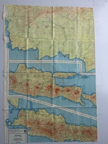 B-24 Liberator Memorial Restoration Australia Inc
Map - British World War II silk map of Sumatra (South) and Java (Extreme North West), 1944
Silk and rayon maps were produced by Great Britain (some 1.75 million in total), the United States (c.7.5 million) and Australia during World War II. They were issued to Allied military personnel as part of 'escape and evasion' kits.This map, printed on rayon, is an original British 'escape and evasion' kit map from World War II.A multi-coloured, contoured, double-sided map printed on rayon, 1944 Series South West Pacific Area (SWPA) and Asia Sheet G Sumatra (South) and Java (Extreme North West) and, on the reverse, Sheet H Borneo (South West), Java and Sumatra (Extreme South)world war ii, silk maps, great britain, a187 -
Whitehorse Historical Society Inc.
Map, Mitcham Riding, n.d
Shire of Nunawading: Mitcham Riding [n.d.] between Mitcham and Heatherdale Roads) (Shows electric light mains, MMBW reserves and railway line.mitcham, maps, vermont -
Stawell Historical Society Inc
Map, Bellaura, County of Borung, 1924
Bellaura, County of Borungstawell -
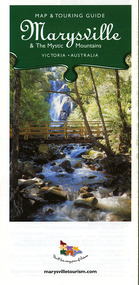 Marysville & District Historical Society
Map (Item) - Map and touring guide, Murrindindi Regional Tourism Association Inc, Marysville & The Mystic Mountains VICTORIA-AUSTRALIA, 08-2002
A fold out map and touring guide of Marysville and the surrounding district published in 2002 by Murrindindi Regional Tourism Association Inc.A fold out map and touring guide of Marysville and the surrounding district published in 2002 by Murrindindi Regional Tourism Association Inc.marysville, victoria, australia, map and touring guide, mystic mountains tourism, the beeches rainforest walk, lake mountain, cambarville, cathedral range state park, the cumberland, abbey green b&b cottages, anastasia fairytale cottage, ashlar cottage b&b, somerled mountain retreat, baree mudbrick cottages, blackwood cottages, camellia cottage, cathedral view b&b, cottage riverside, crossways country inn, dalrymples guest cottages, esa country ministries, hillcrest, keppels hotel motel, kerami house, lomatia lodge, lyell guest cottages, marylands country house, marysville caravan park, marysville holiday cottages, maryton park, melina cottage, moondai farm b&b, mountain lodge marysville, mount cathedral lodge, mystic mountains holiday cottages, nanda binya lodge, rendezvous on murchison, scenic b&b, the hermitage, tower motel, waratah house, willowbank at taggerty, woodlands of narbethong, keppels, lake mountain resort cafe, lanterns at willowbank, mantirri blueberry farm, marysville country bakery, the old woolshed cafe, clearstream olives, uncle fred & aunty val's old style lolly shop, acheron valley alpacas country store & gallery, bruno's art and sculpture garden, country touch, things of sand & stone, willowbank gallery, marysville auto & hardware, marysville newsagency & general store, marysville visitor information centre, narbethong visitor information centre, gallipoli park, keppels lookout, lady talbot drive, steavenson falls, steavenson river, taggerty river, acheron river, black spur trail riding centre, buxton trout farm, lake mountain resort ski hire, lake mountain ski school, marysville district country club, marysville ski centre, narbethong ski hire, rubicon horse riding, country touch tours, murrindindi regional tourism association inc -
 Ringwood RSL Sub-Branch
Map - Vietnam map, 1969-1972 map Vietnam on hard backing
-
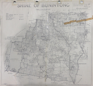 Federation University Historical Collection
Map, Shire of Buninyong, c1970
The Shire of Buninyong was located on the southern side of Ballarat.Two maps of the Shire of Buninyong. .1) Map showing the County divisions, township boundaries, Railway line, State Forest boundary, riding boundary and shire boundary. Identifying words have been added in red and green texta. .2) Shire of Buninyong Parish Plan. Includes Buninyong, Clarendon, Narmbool, Enfield, Lychfield, SCotchman's, Navigators, Warrenheip, Scotsburn, mr Doran, Durham Lead, Cambrian Hill, Napoleons, Garibaldi, Mt Clear, Lal Lal, Bonshaw.1) B.I.A.E., St Martin's, cemetery, mt Buninyong, mt Innes, rly stn shire of buninyong, buninyong, clarendon, narmbool, enfield, lychfield, scotchman's, navigators, warrenheip, scotsburn, mt doran, durham lead, cambrian hill, napoleons, garibaldi, mt clear, lal lal, bonshaw, state forest, elaine, elaine north, cargerie, grenville, mt mercer, millbrook, wallace, yendon, canadian, kaolin deposits, mount helen campus -
Whitehorse Historical Society Inc.
Map, Springvale Road, c1970
Enlarged aerial photo of intersection of Springvale and Whitehorse Roads, Nunawading.Enlarged aerial photo of intersection of Springvale and Whitehorse Roads, Nunawading.Enlarged aerial photo of intersection of Springvale and Whitehorse Roads, Nunawading.springvale road, nunawading, whitehorse road, nunawading, maroondah highway, nunawading, aerial photographs -
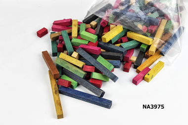 Whitehorse Historical Society Inc.
Education kit - Cuisenaine Blocks
Used in schools to teach maths during 1960-70s. Used by Julie Jones at 10 Francis Street, Blackburn.Set of Cuisenaine Rods, multicoloured. Used as an educational tool to teach children maths. Wood was stained in different colours to donate a numeric value.school, equipment -
Glenelg Shire Council Cultural Collection
Financial record - Cheque Book - Union Bank of Australia Limited, 1926
Used cheque book - The Union Bank of Australia Limited, Portland Free Library stubs dated from May 9 1926 to 22 December 1926, grey card cover.Front: '116' stamp, 4 purple Portland Free Library, Museum & Literary Institute stamps Back: 4 purple stamps, same as frontcheque book, payment, union bank -
 Phillip Island and District Historical Society Inc.
Financial record, Credit account from J.Kennon & Sons for N. L. Smith, Rhyll, 23 March 1914
J.Kennon & Sons were known particularly for their use of the chrome tanning process. They were also buyers and exporters of Australian skins and wool.The firm had tanning works,, established in 1863, offices and stores in the vicinity of River Street, Richmond and a leather warehouse in Bridge Road. [ Source -Heritage Victoria https://www.google.com/url?sa=t&rct=j&q=&esrc=s&source=web&cd=&cad=rja&uact=8&ved=2ahUKEwiI7OnmofT_AhUia2wGHXNGCaUQFnoECBQQAQ&url=http%3A%2F%2Fimages.heritage.vic.gov.au%2Fattachment%2F24257&usg=AOvVaw0ER8QGZ-3eW4PAg0VM909h&opi=89978449]HistoricalCream coloured account with details eg product and amount in black ink. Includes a separate piece of paper attached to page, with a recipe for vermin destroyer typed in red ink.Credit account of N. L. Smith, Rhyll, Phillip Island. One bag of Rabbit Weevily. March 23, 1914 J. Kennon & Sons River Street, Richmondn.l.smith rhyll, j.kennon and sons, rabbit poison, account, vermin -
Whitehorse Historical Society Inc.
Map, Mitcham RSL building, 6/08/1964 12:00:00 AM
Working drawing including pans and elevations for the new RSL building, centre section, in Mitcham.Working drawing including pans and elevations for the new RSL building, centre section, in Mitcham. Architect Bates Smart & Mc Cutcheon.Approved by Nunawading Council 21 Sep 1964.With City of Nunawading Notice to Builders.Working drawing including pans and elevations for the new RSL building, centre section, in Mitcham.mitcham returned servicemens league, mcdowall street, mitcham, harrison street, mitcham