-
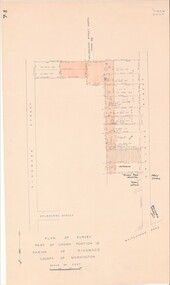
 Stawell Historical Society Inc
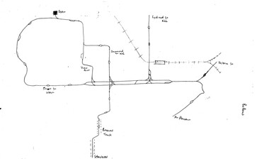
Map, Parish of Mokepilly, County of Borung
Parish of Mokepilly, County of Borungstawell -
 Bendigo Historical Society Inc.
Map - GREAT EXTENDED HUSTLER'S MINE - PLAN OF THE GREAT EXTENDED HUSTLER'S MINE
Plan of the Great Extended Hustler's Mine on the Hustler's Line of Reefs, Bendigo. Bulletin No 33, Plate No X. Lease No 7382. Plan has map of streets. Mine was located in the block bounded by Langston and Anderson Streets and was between the Hustler's Anticline at Surface and the Lightning Hill Anticline at Surface. Latham & Watson's Shaft is also mentioned. Levels are numbered and a table shows the Levels and their Depths. Geological Survey of Victoria. Signed by H A Whitelaw, Underground Suyrvey Office, Bendigo, September 1913. This item has not been scanned or photographed.mining, parish map, great extended hustler's mine, hustler's line of reefs, mining lease no 7382, geological survey of victoria, underground survey office bendigo, h a whitelaw, latham & watson's shaft -
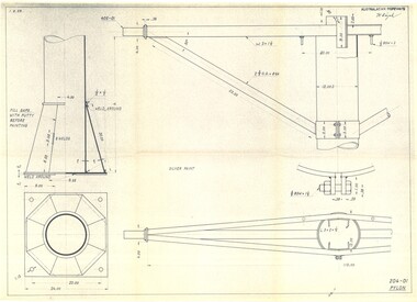
Moorabbin Air Museum
Plan (item) - Tail Rotor Hub Container Assembly CH53E J 787286 SPD 65E13 01-001
United Technologies Sikorsky Aircraft -
Moorabbin Air Museum
Plan (item) - Bristol Aeroplane 170 schematic drawings, Assembly of Detachable Panel
Bristol Aeroplane Company Ltd -
Bendigo Historical Society Inc.
Map - POMPAPIEL : COUNTY OF BENDIGO, 1-10-27
Map. Pompapiel, County of Bendigo, Calivil, Talambe, Yallook, Salisbury, Yarrayne, Janiember East, Waranga Mallee Channel, Judyong Creek.Pompapiel Creek, Bullock Creek, Blind Creek. Photo-Lithographed at the Department of Lands and Survey by W.J. Butson, 1-10-27. Price 1/-. (number 84 in map cupboard 1)W.J. Butson.map, bendigo, pompapiel -
University of Melbourne, Burnley Campus Archives
Plan, Crops Section, 1959-1983
(1) Undated photocopy, not much detail. (2) 'Crops Section 1980's', details with dates 1980-1983. (3) 'Crops Section Responsibilities 1980', labelled with initials. (4) Plans with very little detail, some areas marked, 'Plots 80-82'. (5) 'Crops Section - Burnley (1959?). (6) 'Replanting for students' Rows 6,7,8, 1crops, burnley -
Bendigo Historical Society Inc.
Map - HAWKESTONE : COUNTY OF BENDIGO, December 1953
Map. Hawkestone, Parish, County of Bendigo, County of Talbot, Sutton Grange, Redesdale, Faraday, Elphinstone, Metcalfe, Lyell, Coliban River, Myrtla Creek. By Authority W.M. Houston, Government Printer. Drawn and reproduced at the Department of Lands and Survey, Melbourne. December 1953. Price 2/-. (number 99 in map cupboard 1)W.M. Houston, Government Printer.map, bendigo, hawkestone. -
 Moorabbin Air Museum
Education kit (item) - Course Notes on the Gazelle Engine, Napier School of Instruction
-
Bendigo Historical Society Inc.
Map - PARISH OF SANDHURST 1961, 1961
At Bendigo Parish of Sandhurst. Sheet F.Dept of Lands and Surveybendigo, land sales, parish map -
 Bendigo Historical Society Inc.
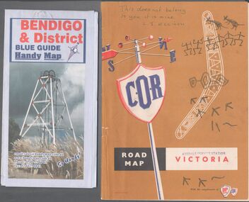
Map - Road maps
Two road maps. On, Bendigo & District blue guide handy map the other a road map of Victoria. On the back of the Bendigo map the date October 2000. On the Victoria map the words in pen "This doesn't belong to you, it is mine". L.J. Ellison and a blue stamp of Axedale service station. Aileen and John Ellison Collection.road map, victoria, bendigo -
 Federation University Historical Collection
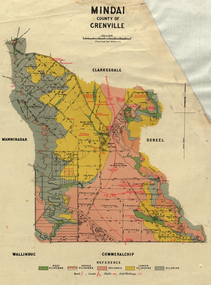
Plan, Mindai County of Grenville
Plan of MIndai showing geological eras.plan, geology, mindai, pitfiled plains, old pitfield plains, william mckay, g. curie, l. lowe, d. mcnaught, grand trunk lead, patrick shelton -
Port Melbourne Historical & Preservation Society
Plan - Annotated and handcoloured by Peter Libbis to indicate his research into Libbis family residences and hotels on copy of a section of an MMBW map, Melbourne and Metropolitan Board of Works, c. 1980s
Peter Libbis obtained these copies from the MMBW when he researched his family history in the 1980s. He has annotated them, colour in hotels etc. Donated to Society in 1997.One of a group of 19 photocopies of various 20th century MMBW plans, annotated/coloured in to indicate residences of Libbis family and local hotels, by Peter Libbis in family and hotel research - Cricket ground, Bridge to Ingles - 1950s?hotels, built environment, melbourne & metropolitan board of works -
 Bendigo Military Museum
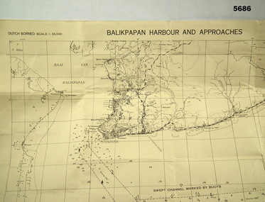
Map - MAP, DUTCH BORNEO
Map identified height of land in area and depth of ocean on approached to Balikpapan Harbour. Identified piers, streets and defences and potentially used for landing or combat in the area. MAP PRODUCED BY 2/1 AUST ARMY TOPO SQN CO. Large Yellow paper map with scale of 1:36,000 of Dutch Borneo Balikpapan Harbour and it's approaches. Map folded into 8.balikpapan harbour, maps -
University of Melbourne, Burnley Campus Archives
Plan, Como, 1983
(1) Como Plant Inventory: Rear of House - Big Pond Lawn, Fountain Terrace and The Paddock dated November 1983, Landform Australia. Numbered list of plants and placement. (2) 2 copies Blueprint - Automatic Watering System Legend by Planned Irrigation Projects Pty. Ltd. (3) Tracing paper and paper plans of Croquet Lawn and Pony Paddock 'Como', Como Avenue, South Yarra - Landscape Studies Assignment 1993.como house, plant inventory -
Port Melbourne Historical & Preservation Society
Plan - Port Melbourne Yacht Club reconstruction, Taylor Howden Pty Ltd, Architects, c. 1990
Clubhouse burned 14 February 1990 and was rebuilt with volunteer labour over many years (opened 1998)Plan of Port Melbourne Yacht Club clubhouse reconstruction 1990 Plan of rebuilt clubhouse; faded almost to illegibilitybuilt environment - recreational facilities, societies clubs unions and other organisations, port melbourne yacht club, pmyc, taylor howden pty ltd -
Port Melbourne Historical & Preservation Society
Plan - Lagoon outlet, Sandridge, 13 Nov 1861
Plan of outlet of lagoon showing proposed new channel, 1861.Signed by Fredk. Wm. Ball, Municipal Surveyor, Sandridge.sandridge lagoon -
 Ringwood and District Historical Society
Map - Plan of Survey, Part of Crown Portion 12, Parish of Ringwood, Victoria - circa 1930
Map of area bounded by Ringwood Street, Melbourne Street and Adelaide Street, showing details of Adelaide Street allotments and existing outbuildings. Certificate of Title numbers include Ringwood Street C/T 3418-553, C/T 3563-433, Adelaide Street C/T 7151-047, C/T 7038-465, C/T 7098-464, C/T 7098-465, C/T 3604-635, C/T 8066-900, C/T 3866-118, C/T 3609-728, and C/T Vol 3670 Fol 133992.Subsequent additional notations identifying 1971 closure of Melbourne Street North, and properties of Hone, Patendon, Pines Hosptial, Mail Office, Presbyterian Church and Falconers Grocery Shop on Whitehorse Road corner. -
 Falls Creek Historical Society
Plan - Diagram of Pylon for New Chairlift
Bob (Herman) Hymans (a former member of the Royal Netherlands Navy was born in Bloemendaal, Holland on 30th September 1922. During World War II he fought against the Japanese in the Dutch East Indies (now Indonesia) and was imprisoned in Changi and on the Burma Railway. After gaining qualifications as a Ski Instructor, Bob arrived in Falls Creek in May 1950. Working as an Instructor and Supervisor at Bogong Lodge, Bob decided his future was in accommodation. He was successful in negotiating an indenture for land from the State Electricity Commission (SEC). It took Bob two years to build his Grande Coeur Chalet but, tragically, it was burned down in August 1961. Bob also built the first Chairlift in Australia. This was a single chairlift and the structure was built from wooden electricity poles. He was constantly full of new ideas and proposals for the village. Bob Hymans died on 7th May 2007. This Collection of documents and letters tells the story of Bob’s endeavours to develop Falls Creek into the ski village it is today. This map is significant because it documents plans being proposed by Bob Hymans for Falls Creek.This diagram is part of Bob Hymans documents. It contains design drawings, measurements and cross sections for one of the pylons for a chairlift proposed by Bob Hymans. The design has been drawn up by Australasian Ropeways. It has been signed by Vladimir Hájek, a Czech engineer who Mr Hymans had consulted on several projects.Top right: AUSTRALASIAN ROPEWAYS with signature V. Hájek Bottom right: 204-01 PYLONmap of falls creek, falls creek leases, falls creek 1980s -
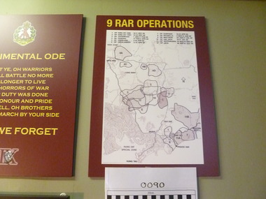 National Vietnam Veterans Museum (NVVM)
Map, 9 RAR Operations
Maroon coloured board with 9RAR Operations. Map of Vietnam inside a white rectangle are regions mared on with outlines and numbered. Just above the map are numbers and operations, dated, that match the region marked.9RAR Operations 1. King hit one 10-11 Dec 68 2. King hit two 12-24 Dec 68 3. Goodwood 1 Jan-17 Feb 69 4. OP Federal 17 Feb-2 April 69 5. OP Overland 2-10 April 69 6. OP overlander 11-15 April 69 7. OP Surfside 16-23 April 69 8. OP Reynella 8May-15June 69 9. OP Matthew 29 June-17July 69 10. Op hatditch 18-31 July 69 11. OP Neppabunna 18 Aug-15 Sept 69 12. OP Jack 30 Sept-31 Oct 699 rar, map -
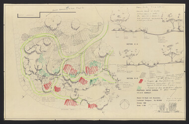
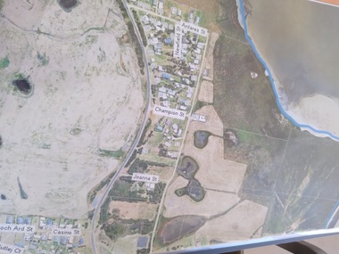 Peterborough History Group
Plan - Moyne Shire Council Aerial photograph, Department of Sustainability and Environment, January 2018
View shows development at the time and showing the town boundary using Vicmap InformationSignificant in that it provides a record of the current state of development of the town. Also, a view of the estuary at that time.A3 size copy of an aerial view of the majority of the town with street names mentioned. curdies river inlet, peterborough, aerial view -
Kew Historical Society Inc
Plan - Subdivisional Sale of 11 Villa Sites, East Kew, 1939
Subdivision plans and real estate flyers/brochures reveal a number of aspects of urban development and history. The Kew Historical Society's collection of these plans, as well as advertisements extracted from magazines, cover key aspects of community development and architectural history of Kew and Kew Eat as well as surrounding suburbs. While most of the plans in the collection were gifted to the Society by the former City of Kew, a number of other plans and advertisements have been donated by individuals, of which this is an example.Single page residential subdivision plan advertising house lots for sale, in what was then designated as East Kew but is now Kew, in the following streets: Burke Road, Enfield Street. The flyer includes a smaller locality plan at right. Information on the flyer indicates that the land was previously owned by the Melbourne & Metropolitan Tramways Board.subdivision plans -- kew (vic.), enfield street -- kew (vic.), burke road -- kew (vic.) -
University of Melbourne, Burnley Campus Archives
Plan, Mr & Mrs Yates, 1993
Plans by John Patrick Pty. Ltd. (1) Tracing paper plan, Yates Landscape Details DRG No P9235-L3. Drawn by M.P. 12.1.93. (2) Tracing paper plan, Irrigation Plan DRG No P9235-L3. Scale 1:100. Drawn by M.P. 20.8.93. (3) Tracing paper plan, Yates Planting and Layout DRG No 9235-L1. Drawn by M.P. 6.1.93.john patrick pty. ltd., mr yates -
University of Melbourne, Burnley Campus Archives
Plan, Design Concept for Quadrangle Entrance, 1990-2000
Design concept for quadrangle entrance. "Please pass on any comments to Michael Green." (1) View from Quad looking towards main building. (2) Plan.michael green, quadrangle entrance -
Ringwood and District Historical Society
Legal record - Conditions of Sale (C.E.Carter), Ringwood - Lot 6, Plan of Subdivision No 4433573, Mrs.R.E.Green to Mr.J.J.Toner, 1947
Particulars and Conditions of Sale of Property , from Mrs.R.E.Green to Mr.J.J.Toner. -
Glen Eira Historical Society
Plan - St Patrick’s Roman Catholic Church, Murrumbeena
There is a photocopy of the commemorating booklet for the blessing and opening of St Patrick’s Memorial Catholic Church Murrumbeena on 15 August 1963. It also includes a brief history of the parish, a plan of the church and a sketch of the church exterior. Second there is an unattributed undated research note of the memorial stones for St Patrick’s Catholic Church and school Murrumbeena. Third is an unattributed, undated handwritten notes on St Patrick’s School buildings regarding teaching sisters and dates when additional classrooms were built. The fourth document is a six page brochure seeking donations from parishioners to commence on 10/04/1966. It includes the church’s financial statement, a picture of the church exterior as the cover and two photographs of the reverends. Inside the booklet.glen huntly, religious services, tweedy e. v, cremin patrick rev., murrumbeena, fox bishop, parish, north road, ellis robert o, clergy, malvern east, memorials, parish of ormond, east boundary road, dalny road, rovira william rev, quillinan james rev, church furniture, murrumbeena road., memorial stone, mannix daniel archbishop, pollard k, catholic church, m.p arbory and co., st patrick’s roman catholic church murrumbeena -
Ringwood and District Historical Society
Legal record - Conditions of Sale (C.E.Carter), Ringwood - Lots 1 & 2, Plan of Subdivision No 11956, J R Jamieson to Holeproof Ltd, 1945
Particulars and Conditions of Sale of Property , from Mr J R Jamieson to Holeproof Ltd -
 Ballarat Tramway Museum
Map, Ballarat and Bendigo tram systems, 1960's or 1970's
Yields information about the extent of the Ballarat and Bendigo tramway systems and possibly has a strong association with the work of Tom Murray.Set of two hand drawn maps of the Ballarat and Bendigo tram systems, showing loops, terminus, depots and rail lines, including out of use loops and reserved track. Possibly made during the 1960's or early 1970's. Drawn on lined foolscap paper - have been torn from a pad.trams, tramways, map, drawings, ballarat, bendigo -
 University of Melbourne, Burnley Campus Archives
Plan, Water Garden, 1987-1995
(1) Water Garden V.C.A.H Burnley Irrigation Plan, drawn by M.D. 12.11.87. (2) Tracing paper copy, Proposed Pool Development Native Garden V.C.A.H. Burnley -Survey of approximate dimensions showing fall and depth of pools. Drawn by J.H.K. 9.9.88. (3) Rough coloured plan, Water Garden Planting Plan. (4) Proposed Water Garden V.C.A.H. Burnley by Robert W. Boyle and Associates October 1988, with handwritten annotations by James Hitchmough. (5) Coloured final version. (6) Tracing paper copy, Planting Scheme Native Garden VCAH Burnley. Design by James Hitchmough. Drawing J.K. 13.8.90. (7) Section Native Grassland Burnley Campus - Larger Tree Cover by Marika Kocsis & Martin Hopkins. Drawn by Leigh Stone 25.9.95. Survey Plan, no key to numbers. (8) Section Native Grassland by Marika Kocsis & Martin Hopkins. Drawn by Leigh Stone 20.9.95. No key to numbers. (9) Tracing paper copy Native Garden by Paul Eaves 6.9.90. Scale 1:100. Also 2 plant lists (11.0478/1 and /2). Also see 11.0478 List of plants. (11) Letter to P. Tulk from Robert Boyle dated 07.10.1988 "Re: Cost Estimates for Construction of Proposed Water Garden."water garden, vcah, robert w. boyle, james hitchmough, jill kellow, marika kocsis, martin hopkins, leigh stone, paul eaves -
 Federation University Historical Collection
Plan - Plans, Ballarat School of Mines Brewery Building Plans, 1995
The Ballarat School of Mines Brewery Building is now a part of the Ballarat Technology Park.Site plan and landscape plan for Stage 3 works for the Ballarat School of Mines Brewery Building. .1) Site plan by Philip Cox Sanderson & Partners, Melbourne .2) Landscape plan by John Patrick Pty Ltd, Landscape consultants, Kew, Victoriaballarat school of mines, brewery building, ballarat technology park, john patrick, philip cox sanderson, landscaping, archtectural plans -
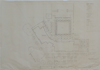
Federation University Historical Collection
Plan - Plans, University of Ballarat Plans for the Library Refurbishment creating the Geoffrey Blainey Research Centre at Mount Helen Campus, 2009, 11/2009
The E.J. Barker Library on the University of Ballarat (now federation University) campus was refurbished in 2009. Six A3 plans by Demaine of the Reading room and storage facility of the Geoffrey Blainey Research Centre.university of ballarat, geoffrey blainey research centre, demaine, refurbishment, library, mt helen library, e.j. barker library, library plan, mt helen library plan, gbrc