-
 Moorabbin Air Museum
Education kit (item) - Generator Control Equipment Training Notes, RAAF School of Technical Training
-
 Melbourne Tram Museum
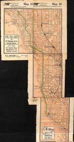
Map, Morgan Street directory - map of VR Trams, Map - 1940s?
Map - assembled from sheets of the Morgan Street directory for the two VR street tramways from St Kilda to Brighton and from Sandringham Station to Beaumaris or Black Rock. Comprises four sheets taped together and one loose sheet. Tram route marked in green felt pen. Has many adverts on the rear and front for funeral parlours, hotels, real estate agents and the like.trams, tramways, map, vr, sandringham, black rock, beaumaris, brighton, st kilda -
 Whitehorse Historical Society Inc.
Map, Walker Park, Nunawading, c1970?
Enlarged aerial photograph of area of Walker Park, Nunawading, 1970 runEnlarged aerial photograph of area of Walker Park, Nunawading, 1970 run.Enlarged aerial photograph of area of Walker Park, Nunawading, 1970 runwalker park, whitehorse road, nunawading, maroondah highway, dunlavin road, nunawading, mitcham technical school, aerial photographs -
Whitehorse Historical Society Inc.
Map, Mitcham RSL Meeting Hall, 4/12/1963 12:00:00 AM
Working drawing including elevations & sections for the new RSL Meeting Hall in Mitcham.Working drawing including elevations & sections for the new RSL Meeting Hall in Mitcham. Architect: Bates Smart & McCutcheon.Working drawing including elevations & sections for the new RSL Meeting Hall in Mitcham. mitcham returned servicemen's league, mcdowall street, mitcham, harrison street, mitcham -
 Ballarat Tramway Museum
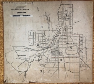
Map, General Accident Fire and Life Assurance, "Sketch Map of Ballaarat including Ballaarat East and Sebastopol", c1940
Yields information about Ballarat c1940 and how the area was rate for insurance purposes.Map - paper mounted onto a heavy card backing titled "Sketch Map of Ballaarat including Ballaarat East and Sebastopol" with a printed label "General Accident Fire and Life Assurance" pasted to the top of the title. Drawn at 30chains to the inch. Map shows the boundaries between the carious insurance classifications in the district, which relates partly to the local government areas at the time. Shows the Yarrowee, Gong Gong Creeks, rail lines, stations, Black Hill and some other features. Includes the Explosives factory area. Does not show the tram lines.trams, tramways, ballarat, maps, insurance, sebastopol -
Moorabbin Air Museum
Map (Item) - Star Chart Adapted From Illyne's Star Chart
-
 Vision Australia
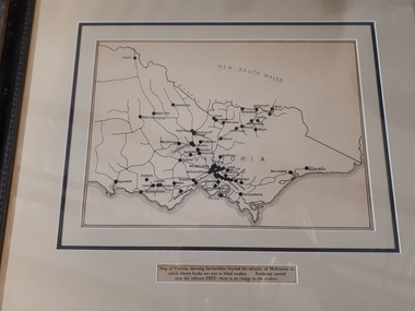
Map - Object, Victorian railways map
A black and white map of Victoria showing the railway lines where mail is transported and the individual towns listed next to the dot that provides location of such. Underneath is written "Map of Victoria showing the localities beyond the suburbs of Melbourne to which library books are sent to blind members. Books are carried over the railways FREE there is no charge to the readers." Through the work of Tilly Aston, braille postage was provided free by the Victorian Railways which greatly assisted the Braille Library in reaching members who resided outside of Melbourne. This map was produced to show the extent of the work by the Victorian Association of Braille Writers and the need for reading materials across the state.Paper of Victorian railway lines mounted in framevictorian association of braille writers, marketing -
 Melton City Libraries
Map, Mount Cottrell Fire group, Unknown
"In 1966, the Mount Cottrell Fire Brigades Group was formed as a way of consolidating the smaller groups around Melton, Rockbank, Toolern Vale, Sydenham, Truganina and Werribee. Its headquarters were established at the home of Ernest ‘Bon’ and Edna Barrie in Ferris Road, Melton. Captain Bon Barrie was a member of the Melton Fire Brigade and elected group and communications officer of the new Mount Cottrell Brigades Group". Fire Brigade Meeting 14th September held at Rockbank Formation a new Group in Region 14 Present: R/O H Rothsay, Assistant R/O R Orchard Tru? G Summerton Purpose of Group The pooling of the equipment in the area should be co-ordinated under one leader. The Brigade and private equipment should be co-ordinated under one leader. Formation was carried unanimously. To be called Mt Cotterill Group. Rockbank nominated Captain E W Barrie elected, Secretary K Watt Toolern Vale. Names listed C/O K L McNaughton Anakie Group COO/O R B Chirnside Lieut J Richmond Capt E Gillespie Toolern Vale Eddie L/ T S Atkin Stan L/T B Storey Bert Sec K Watt Keith Capt E W Barrie Melton Bon L/T K Gillespie Keith A Gillespie Arthur L/T G Lunson George L/T J Robinson Jeff Capt A Marquand Truganina Alan L/T I Cowie Ian Sec T Gard Tom Capt G Harrison Rockbank a/ps G Harrison N Harrison N Fisher a/ps S Hirt Melton Steve Pres M Chomley Sydenham Capt S Hughes Stan Capt L Waterson Werribee Lex Res/o J Hanson G/O S Cooper Bacchus Marsh Syd P/GO W Lidgett Wal Pro/O D Dunton G/O T Healy R C [Mt Macedon] Tom Reg Sec G Douglas Hand written notes of Edna Barrie Typed by Wendy Barrie Maps of the Mt Cottrell Fire groupemergency services, maps -
Beechworth Cemetery Trust
Map - Beechworth Cemetery reproduction of original map - On site in Rotunda, Beechworth Cemetery
Reproduction map displaying all grave sites in Beechworth Public Cemetery. Rotunda, fountain, nursery, memorial wall, pioneer sectionmap displays the plan of grave sitesLaminated Photocopy of original cemetery map with additional information hand-written on the map. All graves at the cemetery set out in denominational sections with hand-written information on additional graves added to sections in Roman Catholic A & C, Church of England A-F, Presbyterian A-C, Methodist/Uniting B and Wesleyan A. Multidenominational hand-written note on Jews section with Trust Minutes 4.7.'83 written next to this addition. Additions hand-drawn of fountain, memorial wall, nursery and pioneer cemetery.rotunda, fountain, nursery, memorial wall, pioneer section, graves, chinese section, un-numbered grave sites, cemetery -
Stawell Historical Society Inc
Map, Stawell Gold Mine, SGM Mineralized System Longitudinal Projection showing Diamond Drilling Holes 2007, June 2007
Section of Big Hill showing Diamond Drill holes through Magdala, Magdala North and Golden Gift Ore bodies to 2000m levelLegend of Mine workings numbered. 1980's mining, gold, map -
Stawell Historical Society Inc
Map, Stawell Gold Field 1878, 1878
Stawell Gold Field 1878stawell, mining -
Moorabbin Air Museum
Map (Item) - Environs of the Top End Map
-
University of Melbourne, Burnley Campus Archives
Map, Plan of Early Melbourne Showing Original Crown Allotments, c. 1852
Copy of 'Map of the City of Melbourne, and its Extension, together with Collingwood, Richmond, Hawthorne, the Emerald Hill, and a portion of Prahran Compiled from the Government Plans and Private Survey by William Green.' (2 copies, one enlarged)melbourne, william green, richmond, hawthorne, collingwood -
Whitehorse Historical Society Inc.
Map, Melbourne Metropolitan Planning Scheme. Map No 39, c1950
Map of central Melbourne showing planning zones with gardens and principal buildings marked.Map of central Melbourne showing planning zones with gardens and principal buildings marked.Map of central Melbourne showing planning zones with gardens and principal buildings marked.maps, city of melbourne, city of fitzroy, city of south melbourne, city of collingwood -
Moorabbin Air Museum
Map (Item) - route map of Australia, ANA australian national airways
-
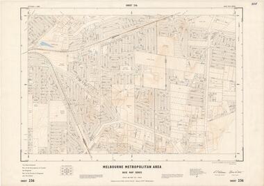 Ringwood and District Historical Society
Map - Melbourne Metropolitan Area Base Map Series, Sheet 236 - Ringwood area, 1961
Map prepared by Dept of Lands and Survey and MMBW from State Aerial Survey June 1957 and Cadastral Survey information May 1961. This sheet comprises parts of the Municipalities of Croydon and Ringwood, and Parishes of Ringwood and Warrandyte.Scale: 400 feet to 1 inch. Contours at 5 feet vertical interval. By Authority: A.C. Brooks, Commonwealth Printer, Melbourne. -
Whitehorse Historical Society Inc.
Map, Belgium WW1 map, Aug 1917
WW1 map of Belgium Edition 1. Sheet 28 S.W. and S.E. with trenches in red around the towns of Comines and Warnetonnon-fictionWW1 map of Belgium Edition 1. Sheet 28 S.W. and S.E. with trenches in red around the towns of Comines and Warnetonworld war 1914 - 1918, maps -
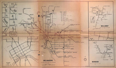 Melbourne Tram Museum
Map - Melbourne - Ballarat - Bendigo Tramways, 23-9-1969
Provides a detailed map of Melbourne, Ballarat and Bendigo tram lines - dated 23-9-1969. Shows street names, depot locations, depot layouts, track details including an insert for Sturt St Ballarat and destination locations. Provides a scale for each system. Not known who prepared the drawing.Yields information about the three operable Victorian systems at the date of preparation.Printed - dyeline? map on a folded sheet of papermap, melbourne, ballarat, bendigo, tramways, diagram -
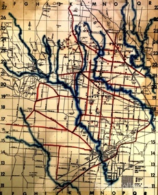
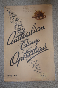 Wangaratta RSL Sub Branch
Map, Australian Army Operations 1940-45
Large fold out map and chronology of Australian Army Operations between 1940-1945 that belonged to Private Joan Spencer VFX12932 (VF507134) born 12/11/1924 at Albury. The family moved to Wangaratta and Joan was educated at Wangaratta High School before joining the Australian Army Medical Women's Service at 115 (Heidelberg) Military Hospital. She served with the 130 Australia General Hospital and was deployed overseas to Japan on 17/6/1947 and returned on 26/1/1949Large cream coloured cardboard folded in three, inside is a coloured map of the Middle East 1940-1942, New Guinea Theatre 1942-1944, Pacific Islands 1944-1945 and Malay and Islands 1942-1945. Front cover has Unit patches from top left to bottom right corner , at top right corner is the rising sun badge and bottom left corner 1940-45 Back cover is a listed Chronology.Hand written at top - VFX Pte Joan Spencer AAMWS 115 (H) M.H.australian army operations, private joan spencer, aamws, 130 agh -
Whitehorse Historical Society Inc.
Map, Melbourne Metropolitan Area Base Map series. Sheet 214, c1960
Map showing northern section of the City of Nunawading together with parts of Shire of Doncaster and Templestowe.Map showing northern section of the City of Nunawading together with parts of Shire of Doncaster and Templestowe. Shows roads, creeks, block numbers and contours at 5 feet vertical increments. Note on map: 'prepared ... from State Aerial Survey, January 1957 and Cadastral Survey information February 1959'.Map showing northern section of the City of Nunawading together with parts of Shire of Doncaster and Templestowe. maps, city of nunawading, shire of doncaster and templestowe -
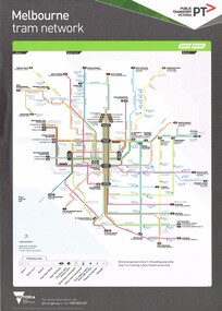 Melbourne Tram Museum
Map, Public Transport Victoria (PTV), "Melbourne tram network", 2015
Printed A4 sheet - double sided on off white paper titled "Melbourne tram network" with PTV, Metro, Yarra Trams logos, shows fare zones, ticketing, free tram zone.. Published 2015.trams, tramways, yarra trams, ptv, maps, free tram, melbourne -
Stawell Historical Society Inc
Map, Joel Joel, Counties of Kara Kara & Borung, 1946
Joel Joel, Counties of Kara Kara & Borungstawell -
Whitehorse Historical Society Inc.
Map, Proposed shared path network, 2001
Draft plans of proposed shared path networkDraft plans of proposed shared path network for Eastern Freeway Extension, Springvale Road to Ringwood.Draft plans of proposed shared path network plans, eastern freeway extension, city of whitehorse, vicroads, city of maroondah, vicroads bicycle coordinator, footpaths, bicycle paths -
Whitehorse Historical Society Inc.
Map, Aerial Photographs Nunawading, 1970
State Aerial Survey, Melbourne 1970.State Aerial Survey, Melbourne 1970. Project runs 34 - 39 - City of Nunawading. Frames numbered from South to North boundaries, each strip numbered from East to West. See table of index and photo numbers attached.non-fictionState Aerial Survey, Melbourne 1970.state aerial survey, aerial photographs, nunawading, mitcham, blackburn, blackburn north, blackburn south, forest hill, vermont, burwood east, vermont south -
 Federation University Historical Collection
Map, Ballarat Goldfield, c1898
This map shows geological features, suggests the last basalt flow, and includes alotments and names of Mining Companies. Although this map has no date on it the Ballarat Industrial School is used for dating purposed. The Ballarat Industrial School ran from 1869-1879, but the term Ballarat Industrial School Reserve was still in use in 1898 and possibly beyond.Geological Map of Ballarat with 3 holes in the left hand side. The map indicates the position of Lake Wendouree, Township of Warrenheip, Ballarat East, Industrial School Reserve, Winters Swamp, Police Paddock, Wyndholm Premptive Right (Salton and Waldie), Black Hill, Vale Park Reserve, Pennyweight Hill, Little Bendigo, Black Swamp Lead, monte Christo Reef, Chinaman's Gully, Miners Rest, Pincotts Dam, Northumberland Gully. It also show the following goldmining companies: City of Ballarat, Kohinor, Hand and Band, Great North West, Northern Junction, Kneeshaw, Rossers Freehold, Silurial.ballarat, warrenheip, lake wendouree, ballarat east, winters swamp, winter swamp, wyndholm premptive right, cemetery, vale park reserve, little bendigo, kneeshaw co., industrial school reserve, kirks dam, pincotts dam, black hill, wombat hill, dead horse gully, miners rest, mt rowan, salton and waldie, rose hill co, great north west no 1, rose's freehold co, hand and band co, police reserve, police paddock, mount rowan, ballarat industrial school reserve, market reserve, winter's swamp, kneeshar co, monte cristo line of reef, chinaman's gully or black snake, milkmaid's gully, ballarat gold field, bakery hil lead, old gravel pits lead, golden point lead, eureka lead, miner's rest, yarrowee creek, leigh creek, black swamp lead, yorkshire reef, nil desperandum reef, cockatoo lead, hit or miss gully, herbert werner frederick de nully, pennyweight hill, esmond's lead, ash's lead, nightingale lead, john bull gully, gladstone reef, whitehorse reef, petticoat creek, pincott's dam, frenchman's gully, tim's crushing plant, jenkin's gully, california gully, drake's creek, sulton and waldie, ballarat undustrial school -
 Bendigo Military Museum
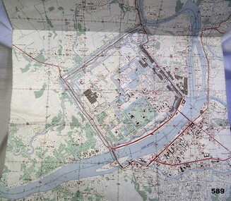
Map - MAP HUE VIETNAM, C.1960’s
The city of Hue is in South Vietnam. The map was used by a member of the AATTV during the Tet Offensive in Thau Thien province. Map brought home from Vietnam by Murray Stanley Metherall. Refer 590.2.Colour printed map of Hue Citadel on paper. Aerial view of land, river and building outlines.hue, vietnam, tet -
Whitehorse Historical Society Inc.
Map, City of Nunawading, 1980?
Map of the City of Nunawading showing streets to south of Burwood Highway and east of Springvale Road.Map of the City of Nunawading showing streets to south of Burwood Highway and east of Springvale Road.Map of the City of Nunawading showing streets to south of Burwood Highway and east of Springvale Road.city of nunawading, historical -
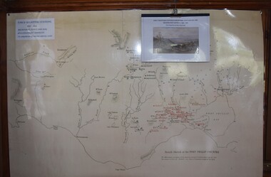 Buninyong Visitor Information Centre
Map, et al, Early Squatters Stations 1837-1838, This map was created in 2016 by a group of U3A Ballarat students under the Tutor, John Olsen
The map shows rivers and pastoral holdings from 1837 to 1838. Stations occupied around Geelong in 1837 are shown in red and those occupied in 1838 are shown in black. Reproduction of a coloured map shows pastoral stations around the Geelong area from 1837-1940. pastoralism, stations, farming, settlement, squatters -
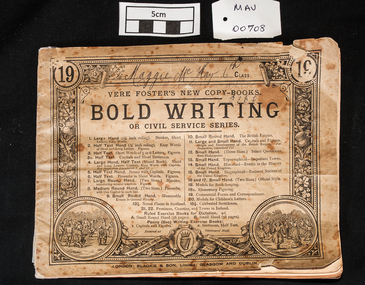 City of Moorabbin Historical Society (Operating the Box Cottage Museum)
Education kit - Vere Foster's New Copy-Book No 19, Bold Writing or Civil Service Series, c1890
This copy book was used by Maggie McKay in 1902 when in 6th Grade at Meeniyan State School (no 3165) and was learning to write in the approved manner. Vere Henry Louis Foster (1819-1900), an educationist, philanthropist, and humanist, who worked devotedly to improve the situation of the Irish poor, published a series of these copy books to improve writing skills, as better literacy and penmanship meant better chances of employment. The books were first published in 1865 and were sold for 1 penny, a fraction of what they cost to produce. In the first year alone one million Foster's Copy Books were sold. The series of books taught children the alphabet and writing. Copy books for older children taught basic business studies and book-keeping.The family of Maggie McKay were early settlers in Moorabbin ShireA school writing copy book with 14 pages divided so that the student copied the text on one half of the page. VERE FOSTERS NEW COPY BOOKS / BOLD WRITING / OR CIVIL SERVICE SERIES London BLACKIE & SON Glasgow and Dublin market gardners, pioneers, early settlers, mooorabbin, brighton, east brighton, bentleigh, correspondence, writing equipment, pen and ink, education, vere foster, irish -
Stawell Historical Society Inc
Map, Township of Stawell, County of Borung, 1958
Township of Stawell, County of Borungstawell