-
 Eltham District Historical Society Inc
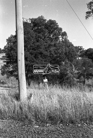
Negative - Photograph, Shire of Eltham, Eltham Meadows Estate, Zig Zag Road subdivision, Jan. 1980
eltham, eltham meadows estate, k.g. mcgorlick pty ltd, mcgorlick real estate, zig zag road subdivision -
 Federation University Historical Collection
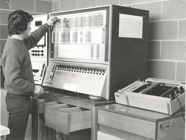
Negative - Image, Ballarat College of Advanced Education Analog Computer, 1971
Ballarat College of Advanced Education (BCAE) acquired an anolog computer in 1971 for $8,856.00. It quickly became obsolete with the rapid evolution of digital computation methods. BCAE in a predecessor instution of Federation UniversityBlack and white photo of a man working on the Analog Computer on the Mount Helen Campus.ballarat college of advanced education, bcae, computers, analog computer, analogue computer -
 Melbourne Tram Museum
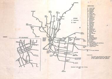
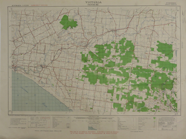
Map, "Tramway and Light Rail System - with substations", 1988
Map or Plan, titled "Tramway and Light Rail System", showing the routes as in 1988 with substations located and their abbreviation and name. Has an enlargement for the city area. Also locates depots and the location of the Carlton Centre control centre Not known who prepared the plan.trams, tramways, map, substation, depots, power supply, electrical engineering -
 Bendigo Historical Society Inc.
Negative - TOM PATULLO COLLECTION: NEW SANDHURST THEATRE
Negative print. The New Sandhurst Theatre. Also found in Box 87 , 2402.112.cottage, miners, new sandhurst theatre., new sandhurst theatre. -
 Bendigo Historical Society Inc.
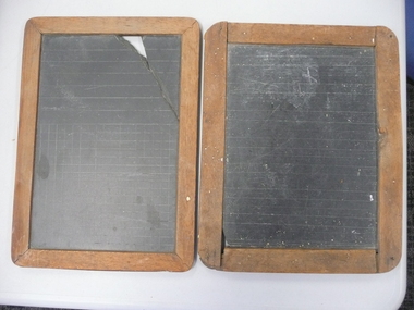
Education kit - WRITING SLATES
Wooden edged Writing Slates (x2). One slate with engraved parallel lines on both sides; other slate with parallel lines on one side and (part) square grid engraved on other side (for arithmetic?). Dovetailing of corners differs between both examples (one with nails - original??). Old (catalog?) numbers of U4 6841 and U4 6842.domestic equipment, writing equipment, slates -
 Whitehorse Historical Society Inc.
Legal record - Land Title, Certificate of Title
Certificate of Title to Roger Robert Charles Jeanne de Stoop and Wivine de Stoop for land in Joseph Street Blackburn, and transfer of land to Tadedor Constructions Pty Limited, also transfer of land from Tadedor Constructions to the City of Nunawading.Certificate of Title to Roger Robert Charles Jeanne de Stoop and Wivine de Stoop for land in Joseph Street Blackburn, and transfer of land to Tadedor Constructions Pty Limited, also transfer of land from Tadedor Constructions to the City of Nunawading.Certificate of Title to Roger Robert Charles Jeanne de Stoop and Wivine de Stoop for land in Joseph Street Blackburn, and transfer of land to Tadedor Constructions Pty Limited, also transfer of land from Tadedor Constructions to the City of Nunawading.de stoop, wivine, de stoop, roger, land titles, virgilia street blackburn, city of nunawading, tadedor constructions pty limited -
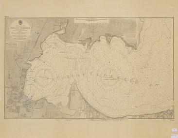 Queenscliffe Maritime Museum
Map - Chart of Geelong Harbour, Geelong Harbour
When Hamilton Hume and William Hovell arrived at the bay in 1824 they met with the local Wautharong people who referred to the bay as "Jillong" and the surround land "Corayo", but by the time the area was surveyed in the late 1830s the Aboriginal names had been swapped. The names "Corayo" and "Jillong" had since been Anglicised to "Corio" and "Geelong".Corio Bay is an important harbour and leisure location in the West and continues to attract development such as the new Tasmania Ferry Terminal.An Admiralty Chart of Geelong Harbour revised in 1954Geelong Harbour Map Ref: 2731geelong, corio, admiralty charts -
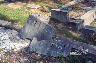 Eltham District Historical Society Inc
Negative - Photograph, Harry Gilham, Grave of Richard George, Emily Ann (nee Davis) and Edith Jane Kaylock, Eltham Cemetery, Victoria, Sep 2009
In his early adult life, Richard Kaylock worked as a whaler (visiting California and New Zealand) and later as a drover on a large cattle station in New South Wales. In 1848 he came to Melbourne, working as a slaughterman, then settled in Eltham in 1854, his occupation thereafter being variously recorded as butcher or orchardist. He also had some experiences at Ballarat during the Eureka Rebellion. He died in 1910 at the age of 84. His obituary described him as a "striking personality" who was "brusque to a fault" and "strictly upright, expecting others to be the same". It seems from his will that he was illiterate. He is buried in Eltham Cemetery with his wife Emily. His property was in Wellington Street (now Brougham Street) and apparently extended across the Diamond Creek. The land on the western side of the creek was farmed, the house being on the eastern side. For many years the Brougham Street bridge was generally known as "Kaylock's Bridge". It formed part of the original coach road to Eltham and in 1922 was described as an "old rustic bridge". Its low level and insubstantial construction made it susceptible to flood damage, necessitating frequent closures until repairs could be carried out. The original bridge was demolished in 1923 and replaced by a "new up-to-date" one. When a lack of finances delayed repairs to the Bridge Street bridge in 1931, traffic had to detour via Brougham Street for some time. Local residents feared that the Bridge Street bridge might never reopen. In Loving Memory Of Our Dear Father & Mother R.G. and E.A. Kaylock Also E.J. Kaylock Died 21st Jan. 1927 The Eternal God Is My PledgeRoll of 35mm colour negative film, 6 stripsKodak GC 400-9eltham cemetery, gravestones, edith jane kaylock, emily ann kaylock (nee davis), richard george kaylock, brougham street bridge, kaylocks bridge -
 Eltham District Historical Society Inc
Negative - Photograph, J.A. McDonald, Eltham-Yarra Glen Road, Lower Plenty footbridge, Sep. 1955
The Eltham-Yarra Glen Road as designated originated at the Shire of Eltham boundary at the Plenty River. West of the river the road was known as the Heidelberg-Eltham Road. The section from the Plenty River is now known as Lower Plenty Road which becomes Main Road. The footbridge no longer exists but was originally sited to the south, adjacent to the old Lower Plenty Bridge, now part of the Plenty River Trail. Record of various Shire of Eltham infrastructure works undertaken during the period of 1952-1962 involving bridge and road reconstruction projects, sometimes with Eltham Shire Council Project Reference numbers quoted. It was during this period that a number of significant improvements were made to roads and new bridges constructed within the shire that remain in place as of present day (2022). In many situations, the photos provide a tangible visible record of infrastructure that existed throughout the early days of the Shire. The album was put together by or under the direction of the Shire Engineer, J.A. McDonald.1955-09, eltham-yarra glen road, lower plenty footbridge, lower plenty, lower plenty bridge, lower plenty road, main road, plenty river trail, bridge construction, infrastructure, shire of eltham -
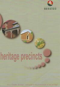 Bendigo Historical Society Inc.
Map - HERITAGE PRECINCTS
Map. Heritage precincts. City of Greater Bendigo - dedicated to the preservation of our heritage.map, bendigo, heritage precincts -
 Bendigo Historical Society Inc.
Map - JACK FLYNN COLLECTION: GIRGARRE, 14/10/1943
Map: Parish of Girgarre , County of Rodney. Parish plan. Same map as 10100.20 but in poorer condition.By Authority, H.E.Daw, Government printer Melbourne. Drawn and Reproduced at the Dept, of Lands and Survey, Melbourne, Victoriamap, rodney, girgarre, girgarre, county of rodney -
Stawell Historical Society Inc
Map, Western Mining Corporation Limited, Shaft Location Plan April 1981, 1981
Western Mining Corporation Ltd Shaft Location Plan 1981 Very Large Plot Showing Contours and Streets Without names. Sheet 1 0f 2 stawell, mining -
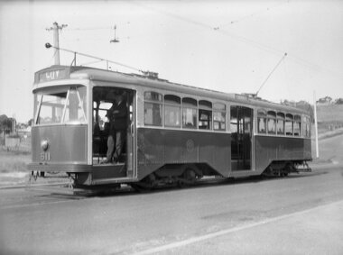
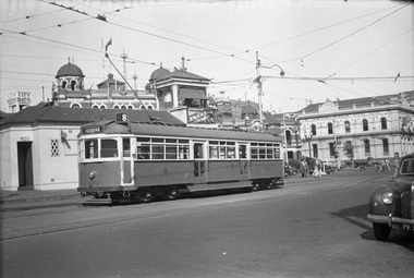 Melbourne Tram Museum
Negative, Wal Jack, 1953?
Black and white negative, by Wal Jack, of W6 970 (Toorak Road Route 8) possibly late 1953 (based on Reg item 5180) at the Victoria St shunt, in Swanston St alongside the signal box and waiting room. In the background is the City Baths and the works of Greer & Ashburner wire works Note the flags in the overhead on the right side of the photo - precursor to the Royal Visit?trams, tramways, w6 class, victoria st, swanston st, route 8, tram 970 -
Bendigo Historical Society Inc.
Map - LANGWORNOR, 17/07/1942
Map: Langwornor, County of Dalhousie. Parish Plan, coloured ( number 165 in Map Cupboard 1)map, dalhousie, parish plan, langwornor, county of dalhousie -
Whitehorse Historical Society Inc.
Legal record - Land Title, Blackburn
Plan of subdivision of part of Crown Portions 81,92 and 89, Parish of Nunawading, County of Bourke. Photograph produced 11 Aug 1947.Plan of subdivision of part of Crown Portions 81,92 and 89, Parish of Nunawading, County of Bourke. Photograph produced 11 Aug 1947.Plan of subdivision of part of Crown Portions 81,92 and 89, Parish of Nunawading, County of Bourke. Photograph produced 11 Aug 1947.blackburn road, blackburn, wellington avenue, central road, gordon crescent, wolseley crescent -
 Ballarat Heritage Services
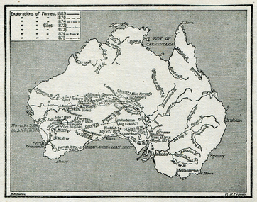
Map, Exploration of Eyre, Sturt, Stuart, Gregory, Burke, and Wills
Copy of a map from 'A Short History of Australia' by Ernest Scott.map, explorers, exploration, stuart, gregory, melbourne, perth, sydney, darling river, murray river, adelaide, albany, fitzroy river, flinders river, brisbane, great australian bight, gulf of carpentaria, mount grey, forrest -
 Ballarat Tramway Museum
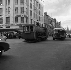
Negative, Geoff Grant, 24/06/1955 12:00:00 AM
Negative No. N337 and black and white print made by a laser printer (stored in folder ) of MMTB works car No. 7, bogie tank car for flushing rail grooves crossing Swanston St. in Bourke St., heading west with Foy and Gibsons building in the background. Photo taken Friday 24/6/1955. Alongside No. 7 is a Spencer St. bus Negative scanned hi res and imaged updated 22/5/2020.trams, tramways, melbourne, bourke st, swanston st., work trams, tram 7 -
 Bendigo Historical Society Inc.
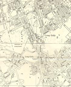
Map - LONG GULLY HISTORY GROUP COLLECTION: MAP OF LONG GULLY AREA
Map of Long Gully area printed on yellow paper. Map shows Eaglehawk Road from Don Street to Weatherall Street, then Mt Korong Road to Dowding Street. Some contour lines on the map.bendigo, history, long gully history group, the long gully history group - map of long gully area, borough of eaglehawk -
 Eltham District Historical Society Inc
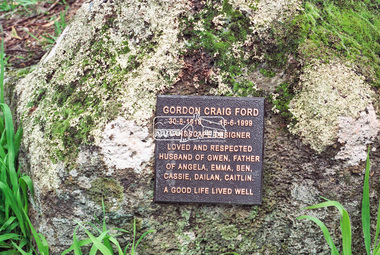
Negative - Photograph, Harry Gilham, Memorial for Gordon Craig Ford, Eltham Cemetery, 1 Aug 2007
Gordon Craig Ford 30-8-1918 - 16-6-1999 Landscape designer Loved and respected Husband of Gwen, father Of Angela, Emma, Ben, Cassie, Dailan, Caitlin. A good life lived welleltham cemetery, gravestones, memorials, gordon craig ford, gwen ford -
 Melbourne Tram Museum
Negative - Copy - Y1 611 Wattle Park, Ray Pearson, early 1930s
Copy negative of a photograph of Y1 611 at the Wattle Park terminus in Riversdale Road, prior to the construction of the shops that were built behind the tram. The driver is standing in the open doorway. The tram line to the Wattle Park terminus opened in 1928. The tram entered service in 1930. Photo early 1930s.Yields information about W5 808 soon after construction.Copy negative of a black and white photographtramcars, tramways, wattle park, y1 class, riversdale road, tram 611 -
 Federation University Historical Collection
Map, Panmure, 1942
Printed colour map on paperpanmure, garvoc, curdie, allansford, bushfield, hopkins river -
Bendigo Historical Society Inc.
Map - PARISH OF SANDHURST 1961, 1961
At Bendigo Parish of Sandhurst. Sheet 13Dept of Lands and Surveybendigo, land sales, parish map -
 Eltham District Historical Society Inc
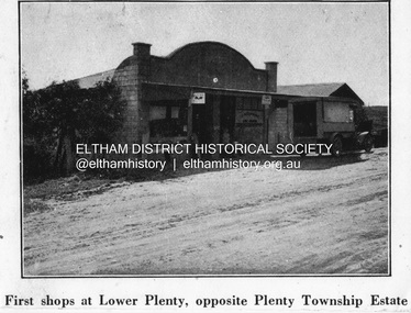
Negative - Photograph, Coghill & Haughton, First shops at Lower Plenty opposite Plenty Township Estate, c.1924
Negative copy and associated print of detail from original Sales Brochure: Plenty Township Estate and Bryn Teg Hill's Estate, Coghill & Haughton, Melbourne (c.1924)Roll of 35mm Black and White negative film, 3 strips, (1 of 14 frames) Print 10 x 15 cmFilm - Agfa Ortho 25lower plenty, bryn teg hill's estate, coghill & haughton, sales brochure, main road, plenty-township-estate, shops -
 Melbourne Tram Museum
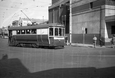
Negative, Wal Jack, c1943
Black and white negative, by Wal Jack, of S169 from Leeds St Footscray in to Barkly St with the destination of Ballarat Road. Has the Amalgamated Cash Drapers store, the Hoyts Trocadero Theatre in the background. Note the tram stop alongside. Photo not dated in Wal Jack album, c1943 - though Could be the same date as Reg Item 5446 - 20-4-1945.trams, tramways, leeds st, footscray, s class, barkly st, ballarat rd, tram 169 -
 Bendigo Historical Society Inc.
Negative - BENDIGO CHINESE TEA HOUSE
Construction of Tea House, Nolan Street, Bendigo. Beside Lake Weeroona.buildings, commercial, tea house -
Bendigo Historical Society Inc.
Map - CAMPBELL COLLECTION: BENDIGO AND DISTRICT MAPS
Map. South and West of Bendigo, Parish of Marong, Moonta, West Bendigo, Specimen Hill, Golden Square, Shire of Marong, Golden Gully, Kangaroo Flat, Diamond Hill, Shire of Strathfieldsaye, Crusoe, Parish of Lockwood.map, bendigo, parishes -
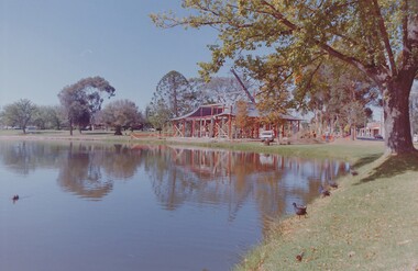
 Eltham District Historical Society Inc
Negative - Photograph, Russell Yeoman, Maroondah Aqueduct, Kangaroo Ground, c.1980
Roll of 35mm colour negative film, 2 strips Colour print (x1)Kodak Safety 5035kangaroo ground, maroondah aqueduct -
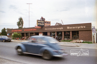 Eltham District Historical Society Inc
Negative - Photograph, Industrial development, Para Road, Briar Hill, c.1984
Views of industrial sites and shop fronts on Para Road, Briar Hill including the business 'Greensborough Motorcycles'. Para Road, Briar Hill is parallel to the Hurstbridge Railway Line. The building 'Greensborough Motorcycles' was destroyed by fire in the early 2000s. Signage on building includes: 'Greensboröugh Motorcycles', 'International Discounters', 'Motor Cycles', and 'Mowers & Chainsaws' and 'Hutchinson's'.Roll of 35mm colour negative film, 4 stripsKodak CP 100 5094briar hill, greensborough, greensborough motorcycles, hutchinson's, industry, international discounters, para road, business -
 Ballarat Tramway Museum
Negative, Wal Jack, 29/03/1956 12:00:00 AM
Yields information about delivery and recommissioning of trams from the Geelong system at the depot.Negative and Digital images of the Wal Jack Ballarat Negative file of possibly Geelong No. 40 on jacks within the depot. See Reg item 5345 for further details. trams, tramways, delivery of tramcars, bogie trams, depot, tram 43 tram 40 -
Stawell Historical Society Inc
Map, Shire of Stawell, 1986
Shire of Stawellstawell