-
 Lakes Entrance Regional Historical Society (operating as Lakes Entrance History Centre & Museum)
Financial record - Ledger, Cash Book, 13625
Entries are hand written in ink, 60 of 84 pages have been used, 20 loose leaf inserts, some pages with pinned inserts, leather bound with heavy cardbaord cover.A cash book containing details of various funds, (Sick and Funeral, Management, Medical, Contingent) for Loyal Cunninghame Lodge of Manchester Unity Independent Order of Oddfellows (MUIOOF).accounts book -
 Bendigo Historical Society Inc.
Map - JACK FLYNN COLLECTION: BET BET SHEET 2, 17/09/1931
Map: Parish of Bet Bet Sheet 2. Parish plan.Photo Lithographed at the Lands and Survey Melbourne. 17.9.31map, gladstone, parish plan, bet bet -
Bendigo Historical Society Inc.
Map - PORTION OF ELMORE ESTATE, 19/10/1920
Map: Portion of Elmore Estate, Parish of Egerton, County of Bendigo. Parish plan Canvas backed ( number 135 in Map Cupboard 1)map, bendigo, rural, elmore estate, egerton, county of bendigo -
Bendigo Historical Society Inc.
Map - PARISH OF WHIRRAKEE, Surveyed 14/07/1904
Map: Parish of Whirrakee. Hand Draughted Parish plan (number 280 in map cupboard 1)map, bendigo, parish plan, whirrakee -
Bendigo Historical Society Inc.
Map - PLAN OF THE TOWNSHIP OF SANDHURST(PHOTOCOPY)
Map: Photocopy of a plan of the Township of Sandhurst. Dated 26 July 1854 ( number 141 in Map Cupboard 1)map, bendigo, city streets, township of sandhurst, early bendigo, city streets -
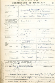 Mission to Seafarers Victoria
legal record (item) - Register, Register II Missions to Seamen Port Melbourne, Circa 1945
The register documents twenty-one weddings that took place in the Mission to Seamen's church district between the 22nd of June, 1945 to the 1st of December 1962. Each certificate is a record of all the information needed to legalise a marriage under Commonwealth law, such as names, dates of birth, marital status, parents and employment. Within the register, there are two letters confirming that grooms are bachelors, and one Statutory Declaration signed by a bride, declaring she is a spinster.The register is a historical record of weddings performed at the Mission to Seamen church between 1945 to 1962.Handwritten in black ink on the front cover: REGISTER NO II (underlined) / MISSION TO SEAMEN / PORT MELBOURNE / NO 19 - / 22-6-45 - / (REGISTER NO 1. / 6-4-29 - 19-3-42 IS KEPT AT / CENTRAL).marriage, wedding, 1945-1962, register, marriages, dio-marriages, mission to seafarers, seamen's mission -
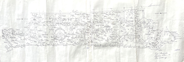
Whitehorse Historical Society Inc.
Map, Shire of Blackburn and Mitcham, 1928
Combination of two sheets of detailed map.Combination of two sheets of detailed map. Many subdivisions shown in details with lot numbers.Combination of two sheets of detailed map. maps, shire of blackburn and mitcham -
 Halls Gap & Grampians Historical Society
Map - Coloured
Background on Bridle Path up Stony Creek Gorge Pre 1840 C. B. Hall, squatter on Mokepilly Run 1841-1842, first European to discover the Fyans Creek valley, the entrance of which became known as Hall's Gap. He later recorded that he followed a number of tracks which he assumed had been made by the Aboriginies and described one as "leading up a wild romantic glen and over on to the source of the Glenelg River". This could well have been the route taken up Stony Creek gorge by the first timber-cutters in this part of the Grampians to the saddle between the Wonderland and Mt. Difficult ranges known as Valley Gap 1850s/60s Timber cutters and shingle splitters were reported to be moving into the eastern side of the Grampians and by the mid 1860s there were a number of families connected to the supplying of timber to Pleasant Creek living in the "Hall's Gap ranges". John Wakeham, the first store owner in Pleasant Creek in 1854, established a timer-mill in upper Stony Creek Gorge in the late 1850s. Wakeham is credited for the clearing and levelling of the first bridle-path up the gorge. 1870s By the mid 1870s the track had been extended over Valley Gap to the Victoria Forest (the upper region of the Victoria Valley). McKeon's bullock team was known to have hauled red gum from the Valley to Stawell in the late 1870s and the 1880s. 1880s In 1887 an article in the Pleasant Creek news describes the Stony Creek Gorge track as "being a ledge alongside the mountain range, formed in the early days with the aid of earth and timber, along which the bullock teams used to travel to Horsham and plains of the Wimmera beyond." 1890s Gold was discovered in the catchment area of Stony Creek and by the end of the 1890s a new track was built from "near the junction of Fyan's and Stony Creeks, up the gorge to the diggings settlement. The mining Department had paid L300 for its construction and, when completed, the track was "three miles and 30 chains in length, the side cuttings at the narrowest part being 10 feet between" and "the watercourses which cross the track at various points" having been "filled up with rocks rolled down the sides of the hills, and consequently there can be no damage caused by bushfires which destroyed the former wooden bridges erected on the old track to Wakeham's saw-mill, the remains of which are still to be seen at the side of the diggings" The article goes on to further describe the track as one which "can with ease travel with a two horse conveyance either up or down" and that the workmen engaged in the construction of the track would be attending "a ball that night at McKeon's farm near the mouth of the gap to celebrate the successful completion of the undertaking". 1900s At what time the bridle path was extended beyond Valley Gap to the Wartook basin on the Mt. Difficult Range has not yet been determined. However, it is known that, by the turn of the century, people were travelling between Halls Gap and the caretakers' residence at Wartook Reservoir along what was now known as the "Bluff Road. Wartook's embankment had been constructed in 1887 and at that time there was already a track from Rosebrook Station homestead (near the present day Wartook Pottery) to the reservoir. Philip Rose owned both Rosebrook and Wartook Stations from the mid 1840s to the late 1850s and had regularly leased the Wartook basin to Cobb & Co. to rest horses there. 1920s Following the war of 1914-1918, tourism really took off in the Grampians, and Halls Gap rapidly grew. People would travel as far as they could on the many tracks then hike to the many lookouts being discovered by local tour guides. This led to the need for access across the range so that horse riders and the increasing number of vehicles could travel between Horsham and Halls Gap. To this end, the Bluff Road was improved and extended on 1929 and at its opening in March, 1930, by Lady Somers it was renamed the Mt. Victory Road.Map of Mt Victory Road and othersaccess routes, mt victory rd, bridle path, roads -
Charlton RSL Sub Branch
Map - Framed map of Bougainville campaign, Framed campaign map of Bougainville campaign November 1944 to June 1945, showing movements of Brigades and actions
Glass framed map of Bougainville Campaign26th Infantry Battallion -
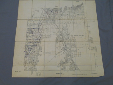
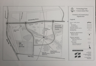 Federation University Historical Collection
Map, Matthew Cibson, University of Ballarat Centre for Environmental Management, Ballarat Technology Park Conservation Plan, 1997, 02/1997
The Ballarat Technology Park is on the Federation University Mount Helen CampusMap showing the Ballarat Technlogy Camp, Greenhill Enterprise Centre, Canadian Wetlands. hand-made brick culvert sleepers, Ballarat-Buninyong Railway Line, IBM Global Services, early wooden bridge, Canadian Creek, Gear Avenue. ballarat technology park, canadian wetlands, greenhill enterprise centre, brick cultert, railway, ballarat-buninyong railway -
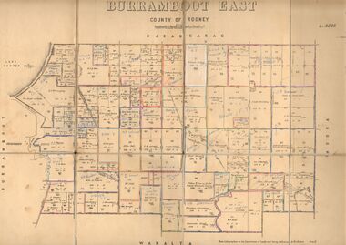 Bendigo Historical Society Inc.
Map - JACK FLYNN COLLECTION: BURRUMBOOT EAST, 21/12/1027
Map: Burrumboot East, County of Rodney. Parish plan.Photo Lithographed at the Department of Lands and Survey, Melbourne by W.J.Butson. 21.12.27map, rodney, parish plan, burrumboot east -
Whitehorse Historical Society Inc.
Map, Dandenong Ranges Area, 1955
Sheet 13. Parts of Parishes: Nunawading, Mulgrave and Scoresby.Sheet 13. Parts of Parishes: Nunawading, Mulgrave and Scoresby. Includes area of Vermont South marked as proposed Township of Norwich. Scale 10 chains : 1 inch. Contours marked.Sheet 13. Parts of Parishes: Nunawading, Mulgrave and Scoresby. maps, vermont south, wantirna, dandenong creek -
Bendigo Historical Society Inc.
Map - LEICHARDT, Circa 1870's
Map: Leichardt, Hand draughted parish plan ( number 300 in map cupboard 1 )map, bendigo, parish plan, leichardt -
Whitehorse Historical Society Inc.
Map, Blackburn Lake - Elmore houses walk, 1/10/1991
Walking map, Ken Green. Copy 1 :Walking map, Ken Green. Copy 1 : Oct '91. See C-B 19 ND655 for copies marked 'November '91'.Walking map, Ken Green. Copy 1 : elmore houses, blackburn lake sanctuary, blackburn, the avenue, blackburn, laburnum street, blackburn, main street, blackburn, gardenia street, blackburn -
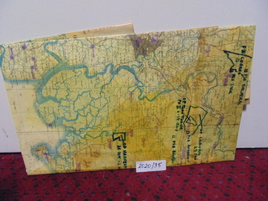 National Vietnam Veterans Museum (NVVM)
Map
A large laminated coloured map of Joint Operations Graphic (ground), Vietnam. there are specific information highlighted in pen.3rar, mcphail collection, map -
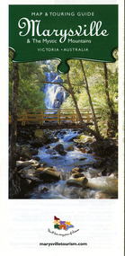 Marysville & District Historical Society
Map (Item) - Map and touring guide, Murrindindi Regional Tourism Association Inc, Marysville & The Mystic Mountains VICTORIA-AUSTRALIA, 08-2002
A fold out map and touring guide of Marysville and the surrounding district published in 2002 by Murrindindi Regional Tourism Association Inc.A fold out map and touring guide of Marysville and the surrounding district published in 2002 by Murrindindi Regional Tourism Association Inc.marysville, victoria, australia, map and touring guide, mystic mountains tourism, the beeches rainforest walk, lake mountain, cambarville, cathedral range state park, the cumberland, abbey green b&b cottages, anastasia fairytale cottage, ashlar cottage b&b, somerled mountain retreat, baree mudbrick cottages, blackwood cottages, camellia cottage, cathedral view b&b, cottage riverside, crossways country inn, dalrymples guest cottages, esa country ministries, hillcrest, keppels hotel motel, kerami house, lomatia lodge, lyell guest cottages, marylands country house, marysville caravan park, marysville holiday cottages, maryton park, melina cottage, moondai farm b&b, mountain lodge marysville, mount cathedral lodge, mystic mountains holiday cottages, nanda binya lodge, rendezvous on murchison, scenic b&b, the hermitage, tower motel, waratah house, willowbank at taggerty, woodlands of narbethong, keppels, lake mountain resort cafe, lanterns at willowbank, mantirri blueberry farm, marysville country bakery, the old woolshed cafe, clearstream olives, uncle fred & aunty val's old style lolly shop, acheron valley alpacas country store & gallery, bruno's art and sculpture garden, country touch, things of sand & stone, willowbank gallery, marysville auto & hardware, marysville newsagency & general store, marysville visitor information centre, narbethong visitor information centre, gallipoli park, keppels lookout, lady talbot drive, steavenson falls, steavenson river, taggerty river, acheron river, black spur trail riding centre, buxton trout farm, lake mountain resort ski hire, lake mountain ski school, marysville district country club, marysville ski centre, narbethong ski hire, rubicon horse riding, country touch tours, murrindindi regional tourism association inc -
Clunes Museum
Financial record - BANK BOOKS, 1893 1929
.1 SMALL GREEN/GREY BANK BOOK, STATE SAVINGS BANK OF VICTORIA, CLUNES. CLUNES LADIES - BENEVOLENT SOCIETY 1929. .2 SMALL DARK BLUE BANK BOOK, THE UNION BANK OF AUSTRALIA LIMITED, CLUNES LADIES BENELOVENT SOCIETY ACCOUNT 1893 - 1905state savings bank clunes, union bank clunes, ladies benevolent fund clunes -
Ringwood and District Historical Society
Legal record - Conditions of Sale (C.E.Carter), Ringwood - Lot 3, Plan of Subdivision No 11956, Mrs S Corrie to Holeproof Ltd, 1944
Particulars and Conditions of Sale of Property , from Mrs S Corrie to Holeproof Ltd. Register No 11956. -
Whitehorse Historical Society Inc.
Legal record - Correspondence, Nunawading Heritage Study Advisory Committee, 29/10/1993 12:00:00 AM
Letter to Secretary, Judith fry, of the Nunawading Historical Society asking for the name of representative to the Nunawading Heritage Study Advisory Committee to be forwarded.Letter to Secretary, Judith fry, of the Nunawading Historical Society asking for the name of representative to the Nunawading Heritage Study Advisory Committee to be forwarded. Cr Tim Shambrook, Mr Peter Chaffey and avid Hodge to be other members of the committee. The terms of reference of the study are attached.Letter to Secretary, Judith fry, of the Nunawading Historical Society asking for the name of representative to the Nunawading Heritage Study Advisory Committee to be forwarded. city of nunawading, nunawading heritage study, shambrook, tim, chaffey, peter, hodge, david, fry, judith, arrowsmith, valda -
Bendigo Historical Society Inc.
Map - EPPALOCK, 15/11/1928
Map: Eppalock, County of Bendigo. Parish plan ( number 170 in Map Cupboard 1)map, bendigo, parish plan, eppalock -
Bendigo Historical Society Inc.
Map - TARNAGULLA SHEET 4, 25/11/1926
Map: Tarnagulla Sheet 4. Parish plan (number 306 in map cupboard 1)map, parish plan, tarnagulla -
Bendigo Historical Society Inc.
Map - GRAZING ALLOTMENTS, 15/10/1894
Map: Grazing Allotments, Parishes of Whirrakee and Bagshot, County of Bendigo. Parish plan (number 331 in map cupboard 1)map, bendigo, grazing allotments, grazing allotments, whirrakee, bagshot -
Bendigo Historical Society Inc.
Map - WESTON, 21/10/1876
Map: Re-Survey of part of the parish of Weston, County of Rodney. Parish plan (number 309 in map cupboard 1)Murray and Hargreave, Authorised surveyorsmap, rodney, parish plan, parish of weston, murray and hargreave -
Port Melbourne Historical & Preservation Society
Financial record - Annual Report, City of Port Melbourne, Annual Statement of Accounts, Oct 1946
City of Port Melbourne Annual Statement of Accounts including Statement of Rates, Statement of Contracts, Statement of Receipts and Expenditure, Statement of Asset and Liabilities, Statement of City of Port Melbourne Annual Statement of Accounts 30 September 1946, including Statements of Rates, Contracts, Receipts and Expenditure, Assets and Liabilities, Electric Supply Accounts etc (May not be in this box)local government - city of port melbourne, t e sullivan, braybrook quarries, sydney sims anderson, g f yates, winifred mary woodruff nee prest, john william (jack) woodruff -
Stawell Historical Society Inc
Map, Riachella, County of Borung, Shire of Stawell, 1920
Riachella, County of Borung, Shire of Stawellstawell -
 Whitehorse Historical Society Inc.
Legal record - Document, Forest Hill Chase Information Centre, 1/11/1990
Report to Information and Public Relations Subcommittee, meeting of 29 November 1990. Information Centre at the Forest Hill Chase.forest hill chase, local government, city of nunawading -
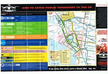 Melbourne Tram Museum
Map, Yarra Trams, "Circuit Map & Transport Guide 2007", Mar. 2007
Fold out map, full colour printed on gloss paper - 8 x 2 folds. showing location of the race track, how tram and rail routes operated, restricted parking area, Metcard, where taxis and limousines could park, bicycle racks. On the reverse side has a detailed map of Albert Park showing the various race facilities and grandstands. Used for the 2007 Grand Prix. See Reg Item 1063 for associated booklet. Item contained with in a plastic envelope with a black neck band. 2 copies held. 1064.1 - similar map for the March 2004 event - see image i3. Added 11-3-2018 from donation of Hugh Waldron.trams, tramways, grand prix, metlink, formula 1, albert park, maps -
 Friends of Ballarat Botanical Gardens History Group
Map - Map of Trees in the Ballarat Botanical Gardens, Tree Research - Location Plan and Naming, 1983
john garner collection, ballarat botanical gardens, gardens, ballarat, trees, map, 1983 -
 Mission to Seafarers Victoria
legal record (item) - Register Receipts, Circa 1967
The receipts are dated from the 16th of December 1967 to the 21st of August 1971. They document some of the information needed on the actual marriage certificate, such as the date and location, bride, bridegroom and celebrant's names, as well as the date the each certificate was sent to registering authority.Part of the record of weddings performed at the Mission to Seafarers between 1967 to 1971.Printed on the front cover: COMMONWEALTH OF AUSTRALIA / CERTIFICATES OF MARRIAGE. The Australian crest is printed above this.marriage, wedding, register, receipt, 1967-1971, mission-to-seafarers, port-melbourne, marriages, dio-marriages, st andrew chapel, st peter chapel -
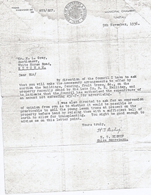 Whitehorse Historical Society Inc.
Legal record - Correspondence, Sale of Halliday land, 5/11/1936 12:00:00 AM
Letter to Mr L. Gray, Auctioneer from H.T. Bishop, Shire Secretary re auction of property of Late R.R. HallidayLetter to Mr L. Gray, Auctioneer from H.T. Bishop, Shire Secretary re auction of property of Late R.R. Halliday, also possibility of selling young lemon trees.Letter to Mr L. Gray, Auctioneer from H.T. Bishop, Shire Secretary re auction of property of Late R.R. Hallidayhalliday, robert ramsay, bishop, herbert thomas, m. l. gray (auctioneers), shire of blackburn and mitcham