-
 Whitehorse Historical Society Inc.
Map, Legislative Council - Electoral Provinces, 1991
State of Victoria. Legislative Council Electoral Provinces. Sheet 3 Metropolitan Map. 1990 - 1991 redivision.State of Victoria. Legislative Council Electoral Provinces. Sheet 3 Metropolitan Map. 1990 - 1991 redivision.State of Victoria. Legislative Council Electoral Provinces. Sheet 3 Metropolitan Map. 1990 - 1991 redivision.electoral boundaries, victoria. parliament. legislative council -
 Federation University Historical Collection
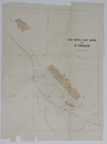
Map, Gold Mining Lease Blocks at St Arnaud, not dated
Printed map on paper with shadingst arnaud, lexell creek, st arnaud creek, wilsons hill, lord nelson -
 Federation University Historical Collection
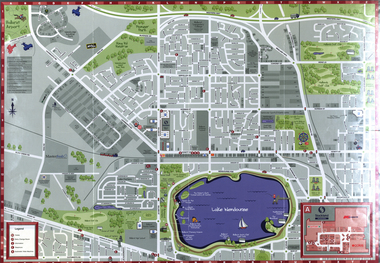
Map, Wendouree (Alfredton and Ballarat North) Retail and Business Guide, 2005, 10/2005
Wendouree, Alfredton and Ballarat North Retail and business guide mapmap, guide, wendouree, alfredton, ballarat north -
 Peterborough History Group
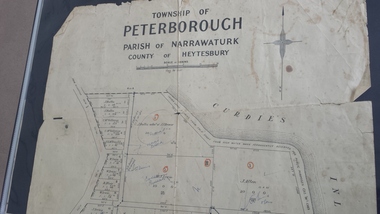
Map - Map of the township of Peterborough, Township of Peterborough
Same map as 4012 but printed names are easier to read. Hand drawn arrows show the road now built connecting Macs St to the Warrnambool RdShows early layout of the town and names of landownersgovernment map of the township of Peterborough with handwritten notes on it. Includes the names of the landowners 1931some hand drawn arrows.peterborough, old maps, maps -
 Flagstaff Hill Maritime Museum and Village
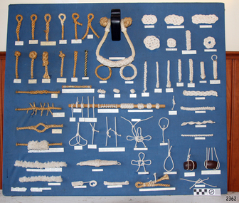
Education kit - Display Board of Knots, Tom Long, DSM (Member of International Guild of Knot Tyers), Before Sept 1986
The Display Board of Konts was handmade in Kings Lynn, Devon, England, by Tom Long DSM, who is a member of the International Guild of Knot Tyers. This display board shows the knots and joins used in ropework performed by a sailmaker and other skilled ropeworkers. It demonstrates the uses of some of the knots, such as for knobs and handles, suspending lengths of wood, reinforcing spliced rope and even for decorative work. The sailmakers travelling as part of the ship’s crew stored their tool kit in a canvas ditty bag. It contained needles, awls, a sailmaker’s leather palmed glove with a heavily reinforced palm - a shuttle to mend and make nets, fids, knives, mallets, brushes, rulers, and rope gauges. Sailmakers used their ropework and knot-making skills for various purposes and chose the type of rope fibre for its particular properties. For example, Italian hemp rope was preferred for the light line used in shore-to-ship rescues because it was lightweight, not easily knotted, and absorbed less water. A supply of various types of rope was a commodity on board a ship and on land in the new colonies. It was flexible, easily stored, and could be worked to create an endless variety of objects on its own or with other materials like wood. An example is a simple rope ladder. Lengths could be combined to make various thicknesses and pieces could be skilfully joined together by splicing. The importance of knots in seafaring cannot be overestimated. When ships relied on only the wind for power and speed, there were a huge number of various ropes in use, particularly with regard to the sails and rigging. Seafarers would be judged on their ability to tie knots speedily and correctly. A mounted display of authentic seaman's knots is on a board covered in blue fabric. Various rope grades and fibres were used to work numerous knots and splices. Some of the uses are familiar, such as the toggle, the pineapple knot, and the Turk’s head. A selection of rope grades and fibres were used to work numerous knots and splices. Some of the uses are familiar, such as the toggle, the pineapple knot, and the Turk’s head. The name or purpose of the knot is on the label below it. Labels below each knot give its name or use.flagstaff hill, warrnambool, maritime museum, maritime village, great ocean road, shipwreck coast, knot display, knot making, ropework, marine technology, sailmaker's work, sailor's knots, ship's rigging, seamen's knots, handmade, rope craft, knots, splices -
 Greensborough Historical Society
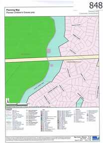
Map, Plenty River Children's Cemetery - location map, 1848-1860
The unmarked graves of the children of two Greensborough pioneer families lie in a private cemetery on the Plenty River. Burials occurred between 1848 and 1860.The significance lies in the association with two of the pioneer families of the Greensborough district. Descendants of both families still live in the area.One page map accompanies article item #804 -
 Federation University Historical Collection
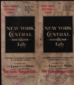
Map, New York Central Hudson River Map and Timetable
Henry Sutton is a talented world-wide accepted inventor with inventions relating to the telephone, photography, wireless, cars, motorcycles, and bicycles as well as many more inventions. Henry was also one of four brothers that ran the Sutton's Music Store after the death of their Father Richard Sutton. Henry Sutton taught Applied Electricity at the Ballarat School of Mines in 1883 to 1886.New York Central Hudson River Map and Timetable with red and black writing used by Henry SuttonUnion Steam Ship Company of New Zealand Limited stamp on the front.henry sutton, union steam ship company of new zealand limited, new york central, hudson river, map -
 Warrnambool and District Historical Society Inc.
Map - Fire Maps, Region 5 Fire Control Map, 1963
Two fire maps of south west Victoria.1 This is a rectangular piece of linen folded several times to form a packet with the front part covered with a brown card. The cover has a blue and white label. The map has a white base with red and green markings and red and black printing .2 As .1 abovenon-fictionTwo fire maps of south west Victoriafire maps, warrnambool history -
Whitehorse Historical Society Inc.
Map, Nunawading Road District, 01/04/1863
Plan of proposed new road - April 1863 & estimated expenses.Plan of proposed new road - April 1863 & estimated expenses. Scale 20 chains per inch. Proclaimed Roads 149.Plan of proposed new road - April 1863 & estimated expenses.nunawading road district, roads and streets -
Clunes Museum
Map, 1890
Features location of Club Hotel, Union Bank, Engine rooms, Port Phillip Hotel, Pyrites furnace, Battery, Office, Smith Shop,Surface Tramway to BatteryPhotocopy of map/plan of Dixon's New North Clunes, Central Clunes Co. and South Clunes utd showing various shafts and pre-emptive rights. Scale 1 inch = 100 feetOn front in red ink; "drawn in 1890"mine shafts, hotels, plans -
Stawell Historical Society Inc
Map, 1955
Illawarra, County of Borungstawell -
 Melbourne Tram Museum
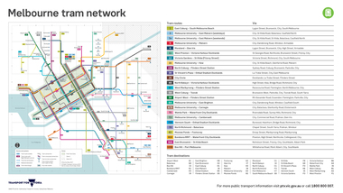
Map, Transport for Victoria, "Melbourne tram network", Feb. 2018
Digital Image of the Feb. 2018 version of the tram and route map for Melbourne titled "Melbourne tram network". Published by Transport for Victoria, effective May 2017 following changes to routes, in particular route 58. Shows each of the route, terminal points, with a legend. Note does not have Yarra Trams logo.trams, tramways, maps, transport for victoria, melbourne, routes -
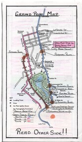 Melbourne Tram Museum
Map, Yarra Trams, "Grand Prix Map", 1996
Laminated sheet - to fit into a pocket - prepared by Greg Rodgers for Camberwell Depot drivers using Park St Kilda Grand Prix services - give details of automatic points, safety notes, details of St Kilda Road points, and what Camberwell drivers are to do. Greg Rodgers advised 5-11-2016, made for the first Grand Prix 1996.trams, tramways, camberwell depot, grand prix, map, public transport, park st st kilda -
Canterbury History Group
Map - Map of Canterbury, Surrey Hills, Mont Albert and Camberwell, c1930s
Map produced and distributed by White & Clarke Real Estate Agents in Canterbury c 1930canterbury, canterbury road, surrey hills, mont albert, camberwell, maps, real estate agents -
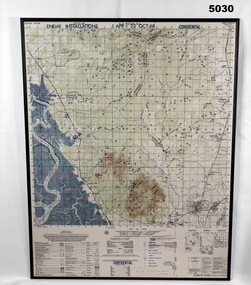 Bendigo Military Museum
Map - MAP, MOUNTED, US Army 1966, Map information as of 1965
Map - colour map titled "XA BINH BA, VIETNAM" Scale 1:50,000. Map depicts "ENEMY INSTALLATIONS 1 APR - 22 OCT 68, CONFIDENTIAL" Map mounted on sheet of timber, sealed with a clear varnish.mapping, vietnam war -
 Melton City Libraries
Map, Streets of Melton, 1963
MELTON’S STREETS Heritage Week 2014 What’s in a Name? Alphabetical List Aboriginal place names, Early Family Names and landowners, Agricultural, Shop and Commercial premises, Places and Events Melton & District Historical Society Street Naming Project 1972 – c 1998 Suburb Name – KURUNJANG - Kirkton, 1972, Brookfield, West, 1988 Melton and Town Centre - A joint collaboration with the Shire of Melton and Subdivision Developers ARNOLD Court – Family house - Arnolds Creek ALKEMADE Drive Family – Lime kilns Coimadia ALEXANDRA Street 1902 – Corination of King Edward VII and Queen Alexandra AVIATOR Place Event, location of plane crash – Jimmy Melrose 1936 Adina ?Annibee - Anniba? Agricultural Avon court .. .. BAKERY Square - Location of Jongebloed shop, bakehouse and stables BALUK Place Aboriginal BARLEYCORN Place Agricultural BILLING Place Name of Jimmy Melrose Uncle Noel Pemberton Billing BLACKWOOD Drive - Alexander Blackwood 1860c Registrar BARRIES Road C. E. Barrie “Darlingsford” farmer 1911, chaff mill owner BROOKLYN Road Staughton family residence. 1875 – Dismantled c 193? CAHILL Drive Family - Glenville Dairy CAMERON Court Family Canopus Place ? CANALLAN Drive Early Surveyor CAMPBELL Court Aviation – Melrose passenger 6th July 1936 CARBERRY Drive Michael, early landowner family CAREW Court Edward and Michael. Royal Hotel. Vera (Carew) Forran Singer - Opera CASEY Court Family CASHIN Court Family CHEVIOT Court Agriculture, breed of sheep CHESNEY Road was re named ( Minns Road being duplicated c 1973) CHRISTINA Crescent Christina McPherson, daughter of James and Mary Mary McPherson. Died 1955 aged 85 years COLLYER Close a deleted street (parallel to Yuille) re-used CORRIEDALE Road Breed of sheep CORR Court Teacher at first school, landowner CROXTON Court Name of the Hornbuckle and Knox family home DALEY Court - William Daley and family 1865 Bootmaker High Street DARLINGSFORD Boulevard - Name of early homestead Thomas B Darling 1853 DJERRIWARRH Court - Parish County of Bourke - very early map. DODEMAIDE Place Early land owners - Melton Football Team had 6 brothers playing c 1924 DONALD Court McPherson family 6 generations in Melton in 1936 DOUGAL Court DUNCAN Court .. .. DUNVEGAN Circuit Home of the McPherson family, castle Isle of Skye Name of bluestone house Smith Street (now at Willows) EMIL Court Jongebloed family EXELL Avenue Farming family Melton Sth- Closer Settlement 1907 EXFORD Road Exe former name of the Werribee river FARMER Court Name of early postmistress FERRIS Road John Ferris Farmer HANNAH Close First name of Hannah Watts – midwife HAYBALE Place Agricultural HELDER Court Early surveyor J Helder Wedge map HEWSON Street Winston Hewson Shire Engineer – check title c 1960 HENRY Street Township map c 1860 HESTON Street Heston Phoenix – C.J. Melrose plane HILDEGARDE Court Jimmy Melrose’s mothers name HOMESTEAD Close HORNBUCKLE Cres Farmers. Three members of family - Shire Presidents HURLEY Street Farmers IAIN Court Descendent of James and Mary McPherson JAMES MELROSE Drive Name appears on 2013 Melton information map JANG Place KURUN – jang KIRKTON Drive Name of the McPherson family home Toolern Vale Road KIRWIN Street Michael early landowners (deleted for freeway construction) KILPATRICKS Road Deleted when Barries Road was extended across Station Rd KOROROIT Court Early map, Parish of Kororoit. Creek name KNOX Circuit Family – Hornbuckle “Croxton Park” KURRUNJANG Drive Aboriginal name for people of the red earth – Suburb name Lara Place ? LLOYD Court Garage owners High Street. Laura lived to 100 years D 1955 LUBY Court John Luby – Crown Grant Land Title LITTLE Court MANNING Avenue Richard, hotel owner 1891 MARGARET Drive McPherson family McDONALD Street Melton South family name McKENZIE Street Township c1860 MORROW Street Early name MOWBRAY Crescent Name of English Melton, popularly believed origin of Melton MYERS Court Early setters c 1866 Crown Grant Land Title NIMMO Street Early name NIXON Street Name submitted by Mary nee Nixon Collins c1985 OLDERSHAW Road Early builder PALMERSTON Street Early township map c 1860 PEART Court Early name PENNYROYAL Avenue Plant growing by the creek. Early name used for the Toolern Toolam Creek PINKERTON Street Family name and early street map PINNACLE Crescent Agricultural - type of wheat PHOENIX Circuit C.J. Melrose Phoenix Heston Plane 2013 map PRATT Family PRIOR Court PYKE Place Brothers – early settlement 1838 RADFORD Court Land owners and business operators. Former Royal Hotel Grocer High Street demolished 1970 RAGLAN Court Hotel 19th century Lord Raglan RALEIGHS Road Oliver Reierson family (Norweigen) Shopkeeper – Dressmakers RIDDELL Drive (misspelt Riddle) Resident and land owner RODERICK Road McPherson family – a re occurring name ROLLAND Court Jones family ROSS Court Daniel. Landowner. Agnes Ross music teacher RUSSELL Court Robert. Early land surveyor of Melton 1853 RYAN Court Family early landowner. Member of the 1862 Road Board SHEBLER Place Augustus early Melton resident – Golden Fleece Hotel SHEEPFOLD Court Farming SHERWIN Court Sherwin Street earliest Township map– became Golf course SMITH Street Early township map. STRATHULLOH Circuit Strathtulloh Homestead. STAUGHTON Street Family – LARGE land owners Strachan ? SWANEY Court Marie Swaney earlier resident of Strathtulloh. SUTHERLAND Family name TOOLERN Street TOOLAM – TOOLERN Creek TULLIDGE St Road marked on 1861 map UNITT Street Early Township c 1860 WALLACE Square Cr Jack Wallace 5 terms as President 46 years unopposed WATTS Court Hannah Watts – midwife, cottage hospital WALSINGHAM Name of house of Minns family. From Walsingham Norfolk England WESTLEY Place Name of Jimmy Melrose Percival Gull Plane WESTLAKE Drive Early resident WHICKHAM Street Family Name Melton South WILSON Road Albert, Melton South YUILLE Street William Cross, early landowner, Rockbank run Zoomed in section of Melton Streets including Church and High Streetlandscapes of significance -
Clunes Museum
Map, 1962
.1 &.2 MAP OF BALLARAT SHIRE GROUP RURAL FIRE BRIGADES FIRE CONTROL MAP. COMPILED BY C. H. FENTON. (2 COPIES) DETAILING SEALED ROADS, STATE FORESTS, PINE PLANTATIONS, FOREST AREAS, RAILWAYS, BOUNDARIES, TOWNSHIP AREAS CEMETERIES, CREEKS, SWAMPS AND HOUSES.local history, document, maps, fire brigade -
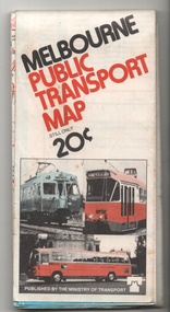 Melbourne Tram Museum
Map, Ministry of Transport, "Melbourne Public Transport Map", c1977
Fold out map (27 sections 9 across x 3 deep), coloured of Melbourne's Tram and Bus routes, route numbers, rail lines, detailed for the central part of Melbourne and insert section for Frankston. On rear description of routes, private bus routes and map of Melbourne metro lines. Has contact details for bookings and lost property etc. Priced 20c Dated 1977, says No. 6 on bottom of rear cover. Note shows route 59 being cut back to the highway.trams, tramways, melbourne, map, tram & bus services, railways, mmtb, minister for transport -
Beechworth Cemetery Trust
Map - Beechworth Cemetery reproduction of original map -Secretary copy, Beechworth Cemetery
Reproduction map displaying all grave sites in Beechworth Public Cemetery. Rotunda, fountain, nursery, memorial wall, pioneer sectionmap displays the plan of grave sitesLaminated Photocopy of original cemetery map with additional information hand-written on the map. All graves at the cemetery set out in denominational sections with hand-written information on additional graves added to sections in Roman Catholic A & C, Church of England A-F, Presbyterian A-C, Methodist/Uniting B and Wesleyan A. Multidenominational hand-written note on Jews section with Trust Minutes 4.7.'83 written next to this addition. Additions hand-drawn of fountain, memorial wall, nursery and pioneer cemetery.rotunda, fountain, nursery, memorial wall, pioneer section, graves, chinese section, un-numbered grave sites, cemetery -
University of Melbourne, Burnley Campus Archives
Map - Topographic Survey, Ararat, 1970
Australia 1:100,000 Topographic Survey map of Ararat district, Victoria dated 1970. Sheet 7423 (Edition 1) Series R 652. Produced by the Royal Australian Survey Corps.ararat, royal australian survey corps -
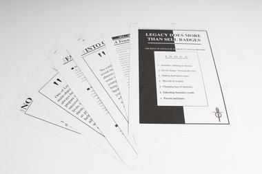 Melbourne Legacy
Education kit, Legacy does more than sell badges: The role of Legacy in Australia's social History. An Australian history resource for use with Secondary Students, 1992, 1993
Education kit produced by Sydney Legacy in 1992 and distributed to Victorian schools by Melbourne Legacy in August 1993. Contains the following: 00058.1 folder 00058.2 covering letter from the Director of School Education Victoria commending the kit to school principals. 00058.3 Index 00058.4 1914 - 1918 "The war to end all wars" (Card 1) 00058.5 Settling into civilian life (Card 2) 00058.6 Making hard times easier (Card 3) 00058.7 Women in war (Card 4) 00058.8 Changing face of Australa (Card 5) 00058.9 Australia's Youth (Card 6) 00058.10 Legacy now & forever (Card 7)Significant as an example of resources produced by Legacy to educate secondary school students about Legacy's history, work and significance in Australian history.Paper card folder with 8 double-sided paper inserts and a covering letter from the Director of Schools Education. Two copies.history, activities -
Stawell Historical Society Inc
Map, 1957
Bolangum, County of Kara Karastawell -
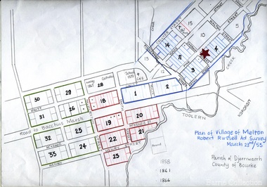 Melton City Libraries
Map, Plan for the Village of Melton, 1853
Site of early village Section numbers 1 - 17 Later became the Flat known as the Common Robert Russell – Surveyor Pinkerton, Sherwin, Bryan, Pyke, Yuille, CollyerMelton Town 1853 Plancouncil -
 Kew Historical Society Inc
Map, Elizabeth Mackie, Kew 1875-1880s, c. 1985
Elizabeth Mackie was a member of the Kew Historical Society and a resident of 1 Molesworth Street. She researched and wrote the booklet 'Artists of Kew' and initiated research into authors with a connection to Kew. One of the most important maps of Kew in the KHS Collection is 'Back to Kew' created by Jesse Dannock. This water damaged map was in many places unreadable, and this re-creation by Elizabeth Mackie only included part of the original text. It was also liberally added to with pictorial symbols.A reinterpretation of the Back to Kew 1875 map created by Jesse Dannock in circa 1931. This hand-drawn map was created by Elizabeth Mackie in the 1980s.elizabeth mackie, plan of kew, maps -- kew (vic.), jesse dannock -
Whitehorse Historical Society Inc.
Map, Sketch plan of Box Hill Cemetery, c1980
Sketch plan of Box Hill Cemeterybox hill cemetery -
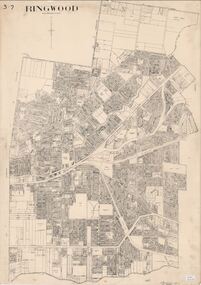 Ringwood and District Historical Society
Map, City of Ringwood - Rateable Properties Layout - c.1966
A0-size (approx) map of named streets, lot-numbered properties and locality features within City of Ringwood boundary. Scale: 8 chains to 1 inch. City Engineer's signature in bottom right corner - Alan Robertson (City Engineer 1958-1987) -
Stawell Historical Society Inc
Map, CFA, Map of Stawell / deep Lead Fire of 31/12/2005, 2006
Fire Started from lightning strike near Deep Lead and Burned on New years Eve with nasty North Wind, Southerly to Black range, Then Easterly towards Great western. Fire Subduded by Rain Event on 2/1/2006.Laminated Coloured Map of Stawell / Deep Lead 4/1/2006 with Fire Perimeters.CFA GIS Services Community Services -
Stawell Historical Society Inc
Map, 1869
Whitehead's Map of Victoria, with Alphabetical Keystawell -
 Bendigo Historical Society Inc.
Education kit - Aileen and John Ellison collection: School Exercise Books
Two exercise books. One with a waterfall on the cover, on the inside the name Leslie John Ellison 38097. Horticulture II notes of lessons for certificate in competency in horticulture II for 1970. Attended Voc. school Sept' 69. State School 1254 Maldon 3463. The second is a brown-beige Shell exercise book with the name J.L. Ellison, state school No. 1008, Axedale 3551 Vic. Bendigo on the cover. Horticulture part I notes of lesson for certificate on competency in Horticulture I. Attended vocation school September 1967. Both exercise books are full of notes, photographs and newspaper articles glued to the pages.horticulture, axedale -
Whitehorse Historical Society Inc.
Map, Map of Mitcham, 1916?
Copy of early map of Mitcham.Copy of early map of Mitcham showing main roads and large blocks of land with owners' namesCopy of early map of Mitcham. mitcham road mitcham, heatherdale road mitcham, whitehorse road mitcham, morton, william, ainger, f, morgan, r. r., harding, w, sergeant, r, mcclelland, john, wilson, w, cook, j