-
 University of Melbourne, Burnley Campus Archives
Map, Map of Showgrounds, c. 1970
Tracing paper plan with grid lines.showgrounds -
Port Melbourne Historical & Preservation Society
Financial record - PMHPS, Pat Grainger, Annual Report 1996, Aug 1996
PMH&PS was incorporated in 1994, and from 1995 was required to hold an AGM and present an Annual Report. These were compiled, designed, printed on photocopier and bound by the Secretary, except for the Tenth anniversary edition.Annual Report of the PMH&PS, 1996 A5 8 pp plus cover - khaki, with photo of Town Hall, Contains financial reports, list of members and photo of recently demolished Missions to Seamen buildingsocieties clubs unions and other organisations, port melbourne historical & preservation society, pmhps, glen cosham -
Whitehorse Historical Society Inc.
Map, Burwood Road, Box Hill City, 15/02/1952 12:00:00 AM
Plan of subdivision of ten blocks in Burwood Road, Burwood.Plan of subdivision of ten blocks in Burwood Road, Burwood between Milford Avenue and Station Street. Marked as Survey Plan No 5441.Plan of subdivision of ten blocks in Burwood Road, Burwood. land subdivision, burwood road, burwood, milford avenue, burwood, central court, burwood -
 Queenscliffe Maritime Museum
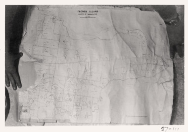
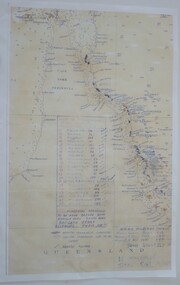
Map - French Island, County of Mornington, French Island map photographs x 2, c1987
Islands off Victorian coastFrench Island mapFrench Island map photographs x 2Reverse " Nil "french island -
 Bendigo Military Museum
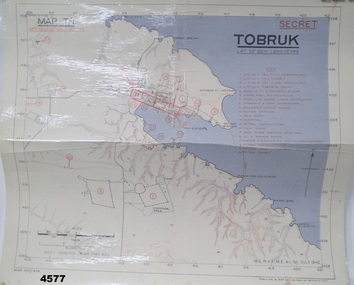
Map - MAP of TOBRUK HARBOUR, 48 Survey Coy S.A.E.C, C.1942
Item in the Doug Dean 2nd AIF collection, refer cat No 4575PMap, laminated, “MAP T/1 SECRET TOBRUK”, shows Tobruk area and harbour, shows creeks, gullies, there are 20 marked installations in red, a rectangular section has been hand drawn on marked “E” & “F”,.At bottom RH corner, “HQ, RAF, ME, A1, 16 JULY 1942”tobruk, maps, ww2 -
 Greensborough Historical Society
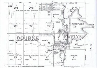
Map, Dianne Edwards, Part of Parish of Yan Yean 1878, 1978
Map includes Crown Portions V - XVII, showing Yan Yean Reservoir, Melbourne-Whittlesea Railway route, names of landowners, roads and various other features west of Greensborough Road. Redrawn by A. R. Blair in 1978.1 p. black and white photocopy of mapyan yean reservoir, yan yean -
Port Melbourne Historical & Preservation Society
Financial record - Annual Report, Port Melbourne Historical and Preservation Society, Pat Grainger, Aug 2016
PMH&PS was incorporated in 1994, and from 1995 was required to hold an AGM and present an Annual Report. These were compiled, designed, printed on photocopier and bound by the Secretary, except for the Tenth anniversary edition and most recent editions, commercially photocopied.Annual report of PMHPS for 2016. Sepia coloured cover with map by Cox in 1864 reproduced2016 Annual report Port Melbourne Historical and Preservation Society (on front cover)societies clubs unions and other organisations, pmhps, port melbourne historical & preservation society, pat grainger, ann gibson, barry jones, graham bride, emma ozols nee teasdale, dan woodham, jim power, george tsingos, glen cosham, john williams, jill dawson, lex johnston, john kirby, jack bolt, suzy milburn, margaret bride, david nicholas, robyn blackmore, sue leong, david thompson, janet bolitho, steve tserkezidis, john may, sandy khazam -
 Warrnambool and District Historical Society Inc.
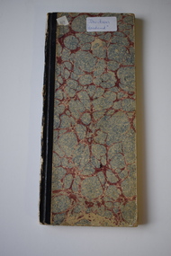
Financial record - Davidson Account Book, 1895
This is a financial record of goods bought from the Warrnambool property of Woodend owned by the Davidson family. Entry dates are from 1895 to 1924. The property Woodend was founded by James Davidson in 1853/1854. James Davidson came to Australia in 1847 and arrived in Warrnambool with his family and his brother in 1850. He had a store in Warrnambool in partnership with J.C. A Kruger and was also an auctioneer. He died as a result of an accident at sea in 1862 and his family continued on at the Woodend farm.This item is of interest as a record of the day to day purchases of a Warrnambool farmer in the late 19th and 20th centuries.This is a hard covered book with a mottled pattern on the cover. The binding is black. The pages contain printed red lines and hand written entries in black ink.warrnambool woodend farm, davidson farm -
Stawell Historical Society Inc
Map, 1866
Locality Plan, Shewing Lands for Sale stawell -
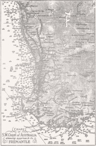 Queenscliffe Maritime Museum
Map - B & W coastal map, Fremantle & SW Coast, Western Australia, Coastal map of SW Coast of Australia & the approach to Fremantle WA, Before donation in 1987
Australian coastal mapsAustralian coastal mapsB&W Coastal map of SW Coast of Australia & the approach to Fremantle WA, from an unknown book, c1864.Reverse " NIL "old maps of australian coast -
 Robin Boyd Foundation
Map, H M Gousha Company, Chicago
walsh st library -
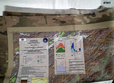 Bendigo Military Museum
Map - MAP of AFGHANISTAN, Australian Government department of defence, Details as of March 2013
Synthetics cloth coloured map of Uruzgan Province Afghanistan, scale 1: 300,000, Escape and evasion type. Has graphs, charts, elevations.maps, afghanistan -
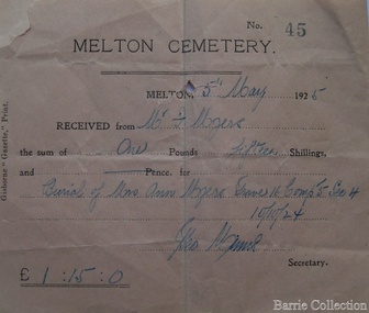 Melton City Libraries
Financial record, Melton Cemetery cheque, 1925
Ann, Henri and their sons Henry and Frederick are buried in the Melton CemeteryFor Ann Myer's buriallocal identities -
Whitehorse Historical Society Inc.
Map, Mason's Paddock, Blackburn, 1919
Mason's Paddock, Blackburn, plan of subdivision, 17 lots, realising auction, Saturday Nov 29, 1919.Mason's Paddock, Blackburn, plan of subdivision, 17 lots, realising auction, Saturday Nov 29, 1919. Agents T.R.B. Morton & Son.Mason's Paddock, Blackburn, plan of subdivision, 17 lots, realising auction, Saturday Nov 29, 1919. t.r.b. morton & son, blackburn, masons paddock, blackburn road, blackburn, masons road, blackburn, canterbury road, blackburn -
Glenelg Shire Council Cultural Collection
Financial record - Invoice - Campbell's Cash Stores, Portland, Aug-39
Invoice for silk hosiery mediums, from Kayser, to Campbell's cash stores, Portland, dated 28 AUG 1939invoice, good, portland trade -
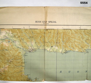 Bendigo Military Museum
Map - MAP, HUON GULF AREA, Aust Survey Corps et al, Aug 43
Refer Cat 5547 - Matheson.This is a single sided map, printed in colour. Scale 1:253,440, 4 miles to an inch, grid squares are 10mm x 10mm. Top right side shows Finschafen. Top centre is Lae, Middle is Salamau. Bottom is Lasanga Island. Top left vicinity is Nadzab and Markham River.There are four "corner" marks in pencil. Two on land and two out in the gulf.ww2, new guinea, map -
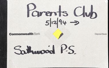 Ringwood and District Historical Society
Financial record, Southwood Primary School, Parents Financial Records
Parents Club cheque books, bank statements and receipts, and Mother's Club Account book. -
Stawell Historical Society Inc
Map, Crocodile Gold Corp, Photographic Aerial View of Big Hill showing underground workings and surface workings and proposed Big Hill Open Pit proposal, December 2014
Crocodile Gold Corp SGM photo Map showing Magdala Decline& Wonga Decline December 2014 Produced for Public Consultation over Big Hill Open Pit Proposal. Aerial Views Stawellmining, gold, map -
Stawell Historical Society Inc
Map, 1894
Section 4 (Taken from Plan No 959)stawell -
 Warrnambool RSL Sub Branch
Map - 1947 Minesweeping map, North Queensland minesweeping map, unknown
1947 an after-effect od WW2Laminated A3 Map plus A4 map in pocket (copies of original)shows location of minefields to be cleared in 1947 and names of minesweeping ships!947 ran history -
Whitehorse Historical Society Inc.
Map, Alterations to residence, 1/02/1979 12:00:00 AM
Plans of proposed alterations and additions to residence for Mr. R. Doreian.Plans of proposed alterations and additions to residence for Mr. R. Doreian at 567 Whitehorse Road, Mitcham Scale 1:100,500|2 copies, 1 stamped APPROVEDPlans of proposed alterations and additions to residence for Mr. R. Doreian.dorien, bob, whitehorse road, mitcham no.567 -
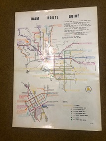 Melbourne Tram Museum
Map, Melbourne & Metropolitan Tramways Board (MMTB), "Tram Route Guide", Jun. 1982
Full colour map or poster printed on clear plastic with an adhesive peel off backing sheets, titled "Tram Route Guide". Map dated 6/82, showing routes with route numbers and names of main destinations. Has notes about the services, weekend bus replacements and telephone numbers for information. 1982 Note this version does not show the route 88 extension as similar map 1098 or 3765 does, but is a later version.trams, tramways, mmtb, map, routes, posters -
Port Melbourne Historical & Preservation Society
Map - MHT General Plan showing Harbour improvements recommended Sir John Coode, Thomas Kell Lith, 1800s
Black and white map "Melbourne Harbour Trust, General Plan showing Harbour improvements, as recommended by Sir John Coode in his report of 17th February 1879" Showing proposed Coode canal and Sandridge, Hobson's Bay, North Williamstown, Footscray, the City, Emerald Hill and also the buildings of "Kitchen and Son" . (copy of original)industry, manufacturing, engineering department, borough of sandridge, engineering - canals and drainage, melbourne harbor trust - port of melbourne authority, j kitchen & sons pty ltd, sir john coode -
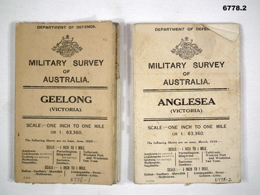 Bendigo Military Museum
Map - MAPS, GEELONG & ANGLESEA, 1928 - 1929
Refer to Cat 6719.2P1. Military Survey map of Australia - Geelong, Vic. One inch to One mile - the map is in colour print. The two outer covers are cardboard, the map then opens up in a multifold manner. Date June 1928 2. Military Survey map of Australia - Anglesea, Vic. One inch to one mile - the map is in colour print. The two outer covers are cardboard. The map then opens up in a multi fold manner. Date March 1929.anglesea, military survey maps, geelong, victoria -
Stawell Historical Society Inc
Map
Parish of Stawell, Sheet 1stawell -
Glenelg Shire Council Cultural Collection
Financial record - Cashbook, 1956
PORT OF PORTLAND COLLECTIONport of portland archives, cashbook -
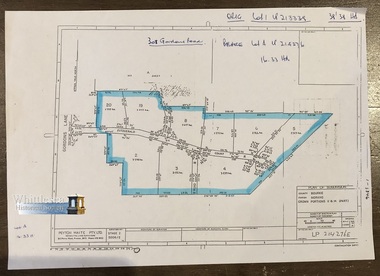 Whittlesea Historical Society Inc.
Map, Peyton Waite Pty. Ltd, Consulting Land Surveyors, Plan of Subdivision, County Bourke, Parish Morang, Crown Portions 11 & 14 (Part)
Morang is now as Mernda. Plan of Subdivision, County Bourke, Parish Morang, Crown Portions 11 & 14 (Part). Gordons Lane and Fitzgerald Court, recorded on the map.A4 page. Map 7 of 20 in green folder. Shows subdivision of Crown Portions 11 &14 (part) blocks numbered 2 - 8 and 19 - 20, sizes of the blocks, and names of the surrounding streets.LP 214276E Undated. Peyton Waite Pty. Ltd, Consulting Land Surveyors, 353 Plenty Road, Preston. Vic.map, subdivision map, morang, mernda, gordons road, fitzgerald court, morang map, mernda map, plan of subdivision -
Whitehorse Historical Society Inc.
Map, Nunawading, 1966
Nunawading's boundaries, schools, topography and railwaysNunawading's boundaries, schools, topography and railwaysNunawading's boundaries, schools, topography and railwaysmaps, city of nunawading, schools -
 Ballarat Tramway Museum
Map, Ken McCarthy, Map of Proposed National Park Line - SPER, mid 1950's
Hand drawn plan on plain foolscap paper of proposed tram line from Loftus to View Point within National Park for South Pacific Electric Railways - with notes, proposed destination roll.trams, tramways, sper, national park line, loftus, destination roll -
Port Melbourne Historical & Preservation Society
Map, Port Melbourne Sheet 4, 1962
Framed line drawn map of Port Melbourne (sheet 4) 1962, covering the area from Beach Street (including Station and Princes Piers) to Plummer Street and Todd Road area to Dow Streetbuilt environment