-
 Moorabbin Air Museum
Manual (item) - CAC CA-31 Advanced Trainer Project, Design Office Directive Advanced Trainer C.A.31
-
Moorabbin Air Museum
Plan (item) - Bristol Aeroplane 170 schematic drawings, G.A. of Pitot Head System ( Auto Pitch Coarsening)
Bristol Aeroplane Company Ltd -
Moorabbin Air Museum
Manual (item) - RAAF Training Aircraft Instruments, Aircraft Instruments General instruments
RAAF Technical Training -
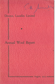 National Wool Museum
Journal, Dennys, Lascelles Limited Annual Wool Report August, 1955
"Dennys, Lascelles Limited Annual Wool Report August, 1955"Three copies. Red paperback stapled booklet entitled "Dennys Lascelles Limited Annual Wool Report August, 1955" including advice and information for wool growers. 19p.Dennys Lascelles Limited Annual Wool Report August, 1955wool brokering, wool growing, dennys, lascelles limited -
Bendigo Historical Society Inc.
Map - SALISBURY WEST : COUNTY OF BENDIGO, 3-3-1944
Map. Salisbury, County of Bendigo, County of Gladstone, Powlett, Yarrayne, Bridgewater, Inglewood, River Loddon, Bullabul Creek, Glenalbyn, Kurting. By Authority H.E. Daw, Government Printer, Melbourne. Drawn and reproduced at the Department of Lands and Survey, Melbourne., 3-3-1944. Price 5/-. (number 94 in map cupboard 1)H.E. Daw, Government Printer, Melbourne.map, bendigo, salisbury west -
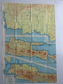 B-24 Liberator Memorial Restoration Australia Inc
Map - British World War II silk map of Sumatra (South) and Java (Extreme North West), 1944
Silk and rayon maps were produced by Great Britain (some 1.75 million in total), the United States (c.7.5 million) and Australia during World War II. They were issued to Allied military personnel as part of 'escape and evasion' kits.This map, printed on rayon, is an original British 'escape and evasion' kit map from World War II.A multi-coloured, contoured, double-sided map printed on rayon, 1944 Series South West Pacific Area (SWPA) and Asia Sheet G Sumatra (South) and Java (Extreme North West) and, on the reverse, Sheet H Borneo (South West), Java and Sumatra (Extreme South)world war ii, silk maps, great britain, a187 -
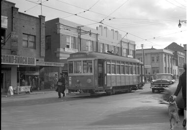
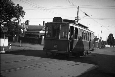
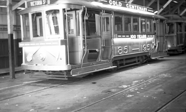 Ballarat Tramway Museum
Negative, Wal Jack, 19.8.1951
Yields information about tram 23 and its appearance in the depot.Negative and Digital images of the Wal Jack Ballarat Negative file of Ballarat 23 in the depot painted for the Centenary of Gold. Very similar to the Keith Kings image at btm1378, possibly at the same time - 19.8.1951trams, tramways, decorated trams, ballarat depot, buildings, gold, centenary of gold, tram 23 -
Moorabbin Air Museum
Manual - Australian Government Project Air 5044 Basic Trainer Project Definition, Visit Report Assessment of Engines and Associated Equipment AAC - TR - 50 - 01
-
 Eltham District Historical Society Inc
Negative - Photograph, Intersection of Mt Pleasant Road at Main Road, Eltham, c.Dec. 1983
Reconstruction work was planned for Main Road to install a roundabout at Mount Pleasant Road. Traffic to Lower Plenty and Templestowe to be diverted down Bridge Street (and Bolton Street) effective January 1984. The proposed roundabout did not proceed. Instead traffic islands on Mount Pleasant Road were installed in place of temporary blocked out islands and revised extended driveway to properties 622-642 Main Road with access off Mount Pleasant Road instead.Film - Kodak CM 400 5079 7 strips, 26 framesinfrastructure, roads, road construction, roundabout, road sign, main road, mount pleasant road, eltham -
 Kew Historical Society Inc
Plan, Melbourne & Metropolitan Board of Works : Borough of Kew : Detail Plan No.1591, 1905
The Melbourne and Metropolitan Board of Works (MMBW) plans were produced from the 1890s to the 1950s. They were crucial to the design and development of Melbourne's sewerage and drainage system. The plans, at a scale of 40 feet to 1 inch (1:480), provide a detailed historical record of Melbourne streetscapes and environmental features. Each plan covers one or two street blocks (roughly six streets), showing details of buildings, including garden layouts and ownership boundaries, and features such as laneways, drains, bridges, parks, municipal boundaries and other prominent landmarks as they existed at the time each plan was produced. (Source: State Library of Victoria)This plan forms part of a large group of MMBW plans and maps that was donated to the Society by the Mr Poulter, City Engineer of the City of Kew in 1989. Within this collection, thirty-five hand-coloured plans, backed with linen, are of statewide significance as they include annotations that provide details of construction materials used in buildings in the first decade of the 20th century as well as additional information about land ownership and usage. The copies in the Public Record Office Victoria and the State Library of Victoria are monochrome versions which do not denote building materials so that the maps in this collection are invaluable and unique tools for researchers and heritage consultants. A number of the plans are not held in the collection of the State Library of Victoria so they have the additional attribute of rarity.Original survey plan, issued by the MMBW to a contractor with responsibility for constructing sewers in the area identified on the plan within the Borough of Kew. The plan was at some stage hand-coloured, possibly by the contractor, but more likely by officers working in the Engineering Department of the Borough and later Town, then City of Kew. The hand-coloured sections of buildings on the plan were used to denote masonry or brick constructions (pink), weatherboard constructions (yellow), and public buildings (grey). That area of Kew bordered by Cotham Road, Park Hill Road, Ermington Lane (now Ermington Place), and Belmont Avenue contained some of the significant homes owned by Kew pioneers. Chief among these was ‘Park Hill’ on an enormous lot facing Park Hill Road. The Jubilee History of 1910 noted, six years after this plan was drawn, that: ‘Park Hill Road, forming the southern boundary of the cemetery, takes its name from Park Hill, the residence of Mr. Thomas Judd, who has resided there since December, 1852.’ Other named houses on the plan include ‘Ferndale’ facing Cotham Road; ‘Ermington’ adjacent to Judd’s Park Hill, facing Park Hill Road; and ‘Gilden’ and ‘Mont Belmont’ facing Belmont Avenue. Mont Belmont was designed by the architectural firm of Reed, Henderson and Smart for William George Lilley in 1887 and was completed in 1888. Lilley was Mayor of Kew in 1887-88, a Justice of the Peace and a member of the first Board of Guardians of Kew’s St. Hilary’s Church of England.melbourne and metropolitan board of works, detail plans, survey plans - borough of kew, mmbw 1591, cartography -
 Melbourne Tram Museum
Negative - Set of 2, Travis Jeffrey, 10/06/1962 12:00:00 AM
B&W negative of tram 459 in Footscray. Tram has destination Williamstown Rd. Driver walking past front of tram. , B&W negative of tram 459 in Barkley St, Footscray at Leeds St. Tram has destination Ballarat Rd. Driver about to board tram, which is ready for shunting.????Paper folder that contained the negative had "NR67B" and date written as 1 Jun 62 in red ink., ?????Paper folder that contained the negative had "NR85B" and date written as 22 Jul 62 in red ink.trams, tramways, x1 class, footscray, barkly st, tram 459 -
Whitehorse Historical Society Inc.
Legal record - Document, Certificate of Title, 28/10/1913 12:00:00 AM
Certificate of Title for Lot 41, Plan of Subdivision no. 2525, Deakin Street Mitcham, owned by State Savings Bank of Victoria.Certificate of Title for Lot 41, Plan of Subdivision no. 2525, Deakin Street Mitcham, owned by State Savings Bank of Victoria.Certificate of Title for Lot 41, Plan of Subdivision no. 2525, Deakin Street Mitcham, owned by State Savings Bank of Victoria.deakin street mitcham, state savings bank of victoria -
Moorabbin Air Museum
Manual (item) - CAC North American Aviation Inc A summary Analysis of the F-86E Defrost system Contract AF33-038-9456 N.A.A. Model NA-170
-
Bendigo Historical Society Inc.
Map - BENDIGO SHEET 2, No date visible
Map: Parish plan showing portion of Bendigo city, West from the Echuca rail line, showing lake weeroona ( number 136 in Map Cupboard 1)map, bendigo, city streets, bendigo sheet 2, bendigo streets -
Clunes Museum
Map - SURVEYERS MAP OF CLUNES, J. FINNIE, 1883
A SURVEYORS MAP OF CLUNES. GEOLOGICALLY AND TOPOGRAPHICALLY SURVEYED BY R.A.F. MURRAY.LITHOGRAPHED BY R. SHEPHERD AND PRINTED BY J. FINNIE MINING DEPARTMENT, MELBOURNE,1883document, surveyers map of clunes, map of clunes -
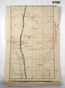 Bendigo Military Museum
Map - MAP, RAVENSWOOD, VIC TRAINING AREA, Aust Army
Items in the collection re Lt Col J. Swatton, refer Cat No 6719.2P for his service details.This is an enlarged version of a contour map. It is undated. On centre left is Ravenswood Train station. The Calder Highway is shown, from the bottom of the map to halfway up left side. Top right side shows "Spring Hill".Each grid square is 1000 x 1000 yards. Top right corner grid is 230,000 E, 450,000 Nth. Magnetic variation when this map was made is 6.55' grid to magnetic Nth. printed onto the map, with an "X" are 'Starting Point', "Debussing Point", and "Assembly Point" . Handwritten in red pencil at top LHS are the letters "C.O".passchendaele barracks trust, map, j.w. swatton -
Moorabbin Air Museum
Plan (Item) - Assorted plans/schematic drawings RAAF, Assorted plans/schematic drawings
RAAF -
 Melbourne Tram Museum
Legal record, Melbourne & Metropolitan Tramways Board (MMTB), "City of St Kilda / Re proposed construction of electric tramway Brighton Road", 8/04/1925 12:00:00 AM
Legal document within a light brown manila document - titled "City of St Kilda / Re proposed construction of electric tramway Brighton Road", dated 8/4/1925 regarding the construction by the MMTB of an electric tramway from the then cable terminus in Brighton Road to Glenhuntly Road and the type of paving to be used. Has the seals of both organisations, signed by the MMTB Chairman and Acting Secretary and the Mayor of St Kilda, Councillor and Town Clerk. Agreement consists of three sheets, bound together with green tape. Only two pages used. Folder has file number "94" written on the outside.trams, tramways, mmtb, city of st kilda, brighton rd, construction, conversion, glenhuntly rd -
Glenelg Shire Council Cultural Collection
Negative - Negative - Whaler's Bluff, Portland, c. 1934
NEGATIVE FOR BLACK AND WHITE PHOTOGRAPH. Close up of Whaler's Bluff, Portland, showing lighthouse and fence, cliffs and seazillah maschmedt, whalers bluff, portland harbour, negative -
 Bendigo Historical Society Inc.
Negative - GERMAN HERITAGE SOCIETY COLLECTION: NEGATIVE - CHERRY TREE HOTEL FAÇADE 1981, 1981
Colour? 35mm negative of the Cherry Tree Hotel Façade 1981. Two negatives show outside of hotel at nightnegative, bendigo, german heritage society, german heritage society collection - negative - cherry tree hotel façade 1981 -
Port Melbourne Historical & Preservation Society
Negative - Negative, Barak Road Development Area Services plan, City of Port Melbourne, Barak Road Development Area Services, 27 Sep 1971
4" x 5" negative of City of Port Melbourne plan, Sept 1971, of services required for development between Barak and Beacon Roadstransport - railways, town planning, local government - city of port melbourne -
Moorabbin Air Museum
Plan (Item) - Plan British Aerospace Hawk Ex GAF
-
 Ballarat Tramway Museum
Negative, Wal Jack, early 1950's
Negative and Digital images of the Wal Jack Geelong Negative file of Geelong No. 1 at the Newton terminus, corner of Aphasia St and Shannon Ave. The house in the background remains in position. The tram has the destination of Station. Note the sign on the left hand side "Major STOP Road". Early !950's. prior to the 1/12/1952 route reorganisation, when Newtown Trams went to Eastern Park. trams, tramways, geelong, newtown, aphasia st, tram 1 -
Whitehorse Historical Society Inc.
Map, Boronia Road, Vermont, 1970
Enlargement of Aerial photograph of Boronia Road Vermont, State Aerial Survey, 1970. Run 37Enlargement of Aerial photograph of Boronia Road Vermont, State Aerial Survey, 1970. Run 37Enlargement of Aerial photograph of Boronia Road Vermont, State Aerial Survey, 1970. Run 37boronia road, vermont, gallus close, vermont, moore road, vermont, carlinga drive, vermont, beleura avenue, vermont, olinda crescent, vermont, penllyne avenue, vermont, holyrood drive, vermont, aerial photographs -
 Bendigo Historical Society Inc.
Negative - BENDIGO CHINESE TEA HOUSE
Construction of Tea Rooms, Nolan Street, Bendigo. Beside Lake Weeroona.buildings, commercial, tea house -
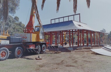
 Melbourne Legacy
Journal - Newsletter, Legacy Newsletter 1984-1986 (For the members of the Melbourne Legacy Widows' Club), 1984 to 1986
Examples of Melbourne Legacy Club newsletters, covering the activities of Melbourne Legacy Widows' Club. Information includes a notice from the Chairman of the Widows' Committee, dates of meetings, possible day trips and theatre outings, and cruises. The ladies were welcome to attend monthly meetings, card afternoons, indoor bowls competitions, outings and tours, plus the annual fete and Christmas concert. The first edition of the newsletter was in 1960, previously there had been a quarterly magazine but the distribution was limited, they changed to a 4 page newsletter format to reach more of the widows. Various pages of interest have been added to show different news items. Other editions haven't been scanned.Brings to life the activities provided for the widows and the work of Melbourne Legacy in the early years.Black typed newsletter x 19 editions from 1984 to 1986, No 143 to 160, each edition 6 foolscap pages. No 143, 31 January 1984 No 144, 31 March 1984 No 145, 31 May 1984 No 146, 31 July 1984 No 147, 30 September 1984 No 148, 30 November 1984 No 149, - MISSING No 150, 31 March 1985 No 151, 31 May 1985 No 152, 31 July 1985 No 152 (2) 30 September 1985 No 153, November 1985 No 154, January 1986 No 155, March 1986 No 157, May 1986 No 158, July 1986, 8 pages No 159, September 1986, 8 pages No 160, November 1986newsletter, activities -
Moorabbin Air Museum
Manual (Item) - Wright Cyclone R1820-50 Navy Engines
Description: SUPERSEDES DI(AF) AAP 7211.019-1-2, PUBLISHED 1/6/1979. 665 pages. Published by RAAF. Published 1/2/1984. AAP 7211.019-1. Boeing 707-338C Aircraft Flight Manual Level of Importance: World. -
Moorabbin Air Museum
Manual - Turbo -Jet Test Beds, ROLLS ROYCE TURBO -JET TEST BEDS ,installation ,operation and maintenance instructions
-
 Mission to Seafarers Victoria
legal record (item) - Register, Marriage Register
The register records the weddings that took place at the Mission to Seafarers church between the 14th of May, 1941 to the 2nd of March, 1947. It documents all the information necessary to perform a legal wedding in Australia. This included Forms of Consent, if one or both the parties were under the age of 21.The register records the twenty weddings that were conducted at the Mission to Seafarers church between 1941 to 1947. Each page of the register is a legally binding document.Handwritten on front cover in blue and black ink: REGISTER NO 5 (underlined) / 14-5-22-3-47. / NOTE MARRIAGES IN 1942 (underlined) / MARRIAGES CELEBRATED ST PETER'S SEAMEN'S / CHURCH MELBOURNE / 31-2-42 / 3-2-42 / 19-3-1942 / ARE REGISTERED ON THE LAST THREE / FORMS OF THE PORT MELBOURNE (underlined) REGISTER / FOR THAT PERIOD FLO (signed). There is also some water stained, and dust markings on the covers.register, 1941-1947, wartime, church-of-england, consent, chaplaincy, dio-marriages, dio-archives, mission to seafarers, seamen's mission, weddings, marriages -
Moorabbin Air Museum
Manual (Item) - Boeing 707-338c systems familiarization handbook