-
 Moorabbin Air Museum
Manual (Item) - Bristol Type 170 Aircraft Mk 21 Series Miscellaneous Systems and Servicing Information
-
 Peterborough History Group
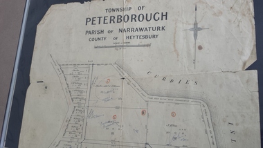
Map - Map of the township of Peterborough, Township of Peterborough
Same map as 4012 but printed names are easier to read. Hand drawn arrows show the road now built connecting Macs St to the Warrnambool RdShows early layout of the town and names of landownersgovernment map of the township of Peterborough with handwritten notes on it. Includes the names of the landowners 1931some hand drawn arrows.peterborough, old maps, maps -
Moorabbin Air Museum
Manual (item) - CAC Collection Banking Records, Yellow Copies Banking from 20/2/73
-
Moorabbin Air Museum
Manual (item) - Avco Lycoming Aircraft Engines Overhaul Manual, RAAF Avco Lycoming Helicopter Engine TVO-435 Series Overhaul Manual
Avco Lycoming Engines -
Moorabbin Air Museum
Manual (Item) - MD-80 Summary - Southern Cross Airlines
-
Moorabbin Air Museum
Manual (Item) - Covers electrical systems, Convair traveler Volume X and number 7
-
 Bacchus Marsh & District Historical Society
Map, Lerderderg District Proposed Irrigation and Water Supply Trust (C). Plan showing overlap in boundaries of the Trust District
The 1886 Irrigation Act in Victoria introduced the first legislation in Australia designed to enable the creation of a detailed scheme for agricultural irrigation. Part of the legislation saw the use of government funds for local irrigation projects. These local projects were managed by local irrigation trusts. The Lerderderg Irrigation and Water Supply Trust was formed in 1890. Printed paper map of the proposed Lerderderg District Irrigation and Water Supply. Plan showing overlap in boundaries of Trust District referred to in Mr Burke's report. The Lerderderg District lies within the Parishes of Korkuperrumul and Merrimu in the County of Bourke. At the top of the map above its title is the letter 'C; in capital lettering. A note on this map states: 'Portion of Bacchus MarshUrban District included in area of proposed Trust District shown by hatched shaded lines thus /////////////irrigation, water supply, lerderderg irrigation and water supply trust -
Moorabbin Air Museum
Manual (Item) - Cessna Models 310F 310G 310H 310I 310J 310K Service Manual
Description: Cessna Latest Revision 1/8/79 Level of Importance: World. -
 Kew Historical Society Inc
Plan, Melbourne & Metropolitan Board of Works : Borough of Kew : Detail Plan No.1561, 1905
The Melbourne and Metropolitan Board of Works (MMBW) plans were produced from the 1890s to the 1950s. They were crucial to the design and development of Melbourne's sewerage and drainage system. The plans, at a scale of 40 feet to 1 inch (1:480), provide a detailed historical record of Melbourne streetscapes and environmental features. Each plan covers one or two street blocks (roughly six streets), showing details of buildings, including garden layouts and ownership boundaries, and features such as laneways, drains, bridges, parks, municipal boundaries and other prominent landmarks as they existed at the time each plan was produced. (Source: State Library of Victoria). This plan forms part of a large group of MMBW plans and maps that was donated to the Society by Mr Poulter, City Engineer of the City of Kew in 1989. Within this collection, thirty-five hand-coloured plans, backed with linen, are of statewide significance as they include annotations that provide details of construction materials used in buildings in the first decade of the 20th century as well as additional information about land ownership and usage. The copies in the Public Record Office Victoria and the State Library of Victoria are monochrome versions which do not denote building materials so that the maps in this collection are invaluable and unique tools for researchers and heritage consultants. A number of the plans are not held in the collection of the State Library of Victoria so they have the additional attribute of rarity.Original survey plan, issued by the MMBW to a contractor with responsibility for constructing sewers in the area identified on the plan within the Borough of Kew. The plan was at some stage hand-coloured, possibly by the contractor, but more likely by officers working in the Engineering Department of the Borough and later Town, then City of Kew. The hand-coloured sections of buildings on the plan were used to denote masonry or brick constructions (pink), weatherboard constructions (yellow), and public buildings (grey). MMBW Detail Plan 1561 outlines those residences in the area bordered by Burke Road, Loxton Street, Mount Street and Barkers Road that had been constructed by 1905 when the land was surveyed. At this time, the area nearest Burke Road had been subdivided and developed whereas the lands to the west were as yet undeveloped. The houses represented are not named on the Plan.melbourne and metropolitan board of works, detail plans, mmbw 1561, cartography -
Moorabbin Air Museum
Manual (item) - Australian National Airways Bristol 170 (Freighter) Instruction Manual, ANA Bristol 170 Instructions, 1954
-
Moorabbin Air Museum
Manual (Item) - T-35A USAF & TV-2 USN - Flight Handbook
-
Moorabbin Air Museum
Manual (item) - Ansett Airlines Douglas DC-9 Flight Study Guide, Douglas DC-9 Flight Study Guide Ansett Airlines of Australia
Ansett Airlines of Australia -
Canterbury History Group
Map - Victorian Railways East Camberwell to Laburnum. Diagram No.3' 58, 1/05/1958 12:00:00 AM
Diagram showing proposed signal and interlocking arrangements for the East Camberwell to Laburnam line 1958canterbury, canterbury station, victorian railways, railway lines -
Moorabbin Air Museum
Manual - CAC Commonwealth Aircraft Corporation, Dowry Aerospace Propellors Standard Practises Manual 60-00-00 Letter of Transmittal for Revision No.3
-
Moorabbin Air Museum
Manual (Item) - LTN-51 Inertial Navigation System , Installation Instructions Aero Products, LTN-51 Inertial Navigation System
Part Number 662800 -
Glenelg Shire Council Cultural Collection
Financial record - Passbook - State Savings Bank of Victoria, Portland Free Library, 1922-1924
Front: purple stamp 'Cancelled carried forward to new passbook' 2 purple stamps 'PFL & LI' Back: 2 'cancelled' stamps, 1 PFL&LI' stampglenelg shire council archives, portland free library, administration, finance, savings -
Beechworth Cemetery Trust
Map - Beechworth Cemetery reproduction of original map - On site in Rotunda, Beechworth Cemetery
Reproduction map displaying all grave sites in Beechworth Public Cemetery. Rotunda, fountain, nursery, memorial wall, pioneer sectionmap displays the plan of grave sitesLaminated Photocopy of original cemetery map with additional information hand-written on the map. All graves at the cemetery set out in denominational sections with hand-written information on additional graves added to sections in Roman Catholic A & C, Church of England A-F, Presbyterian A-C, Methodist/Uniting B and Wesleyan A. Multidenominational hand-written note on Jews section with Trust Minutes 4.7.'83 written next to this addition. Additions hand-drawn of fountain, memorial wall, nursery and pioneer cemetery.rotunda, fountain, nursery, memorial wall, pioneer section, graves, chinese section, un-numbered grave sites, cemetery -
National Vietnam Veterans Museum (NVVM)
Manual, Machmeter incl. code No KMA-0301, KMA-0303 & KMA-0304
royal australian airforce - manuals -
 Bacchus Marsh & District Historical Society
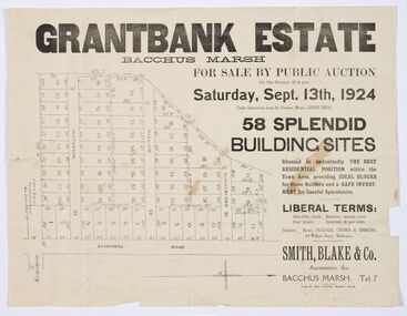
Map - Land Sales Plan, Grantbank Estate Bacchus Marsh, 1924
The Grantbank Estate was a parcel of land close to the centre of the shopping area of Bacchus Marsh which was sub-divided and offered for sale in 58 lots on the 13th September, 1924. It comprised an area of 15 acres, being a portion of the Millbank Estate which had been in the hands of the Grant family for 75 years. The lots had frontages to Gisborne Road, Patterson, William and Sutherland Streets. This was a significant sub-division of land and represented a major expansion of residential housing in Bacchus Marsh in the early 20th century.This land sale map is a typical example of housing estate land sales advertising maps produced by real estate agents in this era. The map is significant for the detailed information it provides about when and where land was sold for new housing estates in Bacchus Marsh in the early twentieth century.Printed paper mapland sales bacchus marsh, land subdivsion bacchus marsh, housing estates land sales bacchus marsh, grant family bacchus marsh -
 Ballarat Tramway Museum
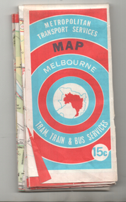
Map, Ministry of Transport, "Melbourne Transport Services Map - Tram, Train and Bus Services", 1974
Coloured map of Melbourne's Tram and Bus routes, route numbers, rail lines, detailed for the central part of Melbourne and insert section for Frankston. On rear description of routes, private bus routes and map of Melbourne metro lines. Has contact details for bookings and lost property etc. Priced 15c. Inscription dates the map as 1974. Yields information about public transport services in Melbourne as a comparison with that of Ballarat.Fold out map (27 sections 9 across x 3 deep), printed on paper.trams, tramways, railways, melbourne, map, tram and bus services, mmtb, minister for transport, public transport -
Moorabbin Air Museum
Manual (item) - Atar 09C Overhaul Manual, Atar 09C Overhaul Manual Part 4 Cleaning and Surface Treatments
Snecma Atar -
National Vietnam Veterans Museum (NVVM)
Manual, Magnetic Relay switch thorn type T100B
royal australian airforce - manuals -
Moorabbin Air Museum
Manual (item) - Repair And Reconditioning Instructions Canberra mk 20/21, RAAF Repair And Reconditioning Instructions Canberra mk 20/21
-
Moorabbin Air Museum
Plan (item) - Beam Installation Untied Technologies Sikorsky Aircraft
Drawing Number :95725-75246 -
Whitehorse Historical Society Inc.
Map, Subdivision Plan for part of Blackburn Park, c1910
Photocopy of advertisement for sale of subdivision of area in BlackburnPhotocopy of advertisement for sale of subdivision of area in Blackburn between the railway line and Whitehorse Road between Station Street and Alfred Street. Some purchasers noted between 1903 - 1912.Photocopy of advertisement for sale of subdivision of area in Blackburnland subdivision, whitehorse road, blackburn, station street, blackburn, railway road, blackburn, queen street, blackburn, albert street, blackburn, chapel street, blackburn, george street, blackburn, cottage street, blackburn, alfred street, blackburn -
Moorabbin Air Museum
Manual (item) - Bristol Salvage Manual for the Hercules Engines Book 40 Sect.19 Vol.2, Bristol Salvage Manual for the Hercules Engines
-
Moorabbin Air Museum
Manual (collection) - RAAF Hercules C130 Airframe Courses
-
 Ballan Shire Historical Society
Map - Map. Kerrit Bareet, Department of Lands and Survey, Kerrit Bareet. County of Grant, 08/1944
A map of the Kerrit Bareet area within the County of Grant showing properties and names of owners in 1944.Significant to people researching land usage and ownership. Also those researching families in the area at that time.A map of Kerrit Bareet in the County of Grant. Black printing on buff coloured paper. Details roads, rivers, railways, property boundaries and names of property owners and towns and villages. The map is easily readable although there is some physical damage and that and the borders have been reinforced with sellotape. Shows a Scale in Chains and Price 2/.gordon, bungal, kerrit bareet, lal lal, moorarbool river, warrenheip, bungaree, wallace, moorarbool west -
Moorabbin Air Museum
Manual (Item) - Wright Cyclone Series 9Gc Engines
Description: SUPERSEDES PREVIOUS EDITION, PUBLISHED 1/5/1942. 134 pages. Published by Wright Aeronautical Corporation. Published 1/12/1942. Catalog Part No. 853544. Parts Catalogue for Wright Cyclone 9 Aircraft Engines Model R-1820-52 Level of Importance: World. -
Moorabbin Air Museum
Manual (Item) - Meteorology For Pilots A Reference Text For CPL And SCPL/ATPL Students