-
 Tatura Irrigation & Wartime Camps Museum
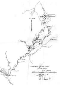
Map - Map - Photocopy, New Guinea Escape Route
At the end of January 1942 there was only about 250 men left in Wau, as the women and children had been evacuated by air a little earlier. With no planes to take the men they had to make their own way to Port Moresby and then travel by ship to Australia. Some men went down to Salamaua and made their way along the north coast, but small groups also made their way over the Owen Stanley Ranges; rafting down the Lakekamu RIver to Yule Island and by boat to Port Moresby. Donor Vanessa Kiessling's Father was part of the second group, and had drawn a detailed map of their route. This might be the same route taken by Rev. Willi Hertle (Ref C0750)Photocopy of New Guinea map showing escape routePlan of surveyed route from Edie Creek to Bulldog Dromepapua new guinea, escape, map, wau, willi hertle, kiessling -
 Eltham District Historical Society Inc
Map (item) - Sales Brochure, Plenty Township Estate and Bryn Teg Hill's Estate, Coghill & Haughton, Melbourne, c.1924
Plenty Township Estate "The rapid growth of Greensborough and the great traffic development on the main road between Heidelberg and Eltham augurs well for Plenty Township Estate. Already a Store, Post Office and State School have been started, and the activities of the Local Progress Association will help the district forward considerably. Within walking distance of the Montmorency and Greensborough stations." Bryn Teg Hill's Estate "Better known as "The Old Sand Hill, "within walking distance of the Montmorency and Greensborough railways stations." "Some few years back Mrs Thomas subdivided portion of the Sand Hill Paddocks, and the areas sold have been settled and many converted into charming outer suburban garden homes with cultivation and orchard plots. The south-eastern slope gives the land a grand outlook over the Yarra Valley on to the Dandenoings, and the are is very picturesque and homely." "A number of the blocks contain large deposits of valuable building sand, which should prove good speculation in view of the forecast for further rapid home development along the Eltham Suburban Electric Service." Sand Hills Road (Old Eltham Road) Date estimated as c.1924 - Electricification of railway line to Eltham referenced on map occured April 1923 and Mrs Mary Thomas died August 1925. Her home Bryn Teg became part of the Heidelberg Golf Club in 1927.The establishment of Lower Plenty as a suburban growth area supported by easy commuting facilitated by the elctrification of the Eltham railway linebonds road, bridge, bryn teg hill's estate, coghill & haughton, eltham road, heidelberg golf club hotel, houses, lower plenty, lower plenty bridge, lower plenty road, main road, plenty hotel, plenty river, plenty township estate, real estate agent, sales brochure, sand hills road, the old sand hill, sand hill paddocks, woodfull road, old eltham road, bryn teg, mrs m thomas -
 National Vietnam Veterans Museum (NVVM)
Map, C. 1969 - 70
Colour map of Vietnam with military locations shown.map, vietnam -
 Whitehorse Historical Society Inc.
Map, Map of East and South eastern suburbs of Melbourne, 1930s
Map of suburbs of Melbourne from Kew to Ringwood and South Morang Station to East Oakleigh.Map of suburbs of Melbourne from Kew to Ringwood and South Morang Station to East Oakleigh.Map of suburbs of Melbourne from Kew to Ringwood and South Morang Station to East Oakleigh.blackburn, mitcham, hawthorn, box hill, doncaster, templestowe -
 Whitehorse Historical Society Inc.
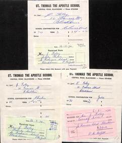
Financial record, St. Thomas The Apostle School, 1970
3 invoices and receipts to J. Foley from St. Thomas The Apostle School3 invoices and receipts to J. Foley from St. Thomas The Apostle School for Christine and Julienon-fiction3 invoices and receipts to J. Foley from St. Thomas The Apostle Schoolst. thomas the apostle primary school, central road blackburn, foley j -
Bendigo Historical Society Inc.
Map - CITY OF SANDHURST SHEET NO.6, 25/04/1882
Map: City of Sandhurst sheet No. 6. Parish planmap, bendigo, parish plan, sandhurst -
Bendigo Historical Society Inc.
Map - CAMPBELL COLLECTION: BENDIGO AND DISTRICT MAPS, March 1947
Map. Mandurang, County of Bendigo, Sandhurst, Strathfieldsaye, Sedgwick, Sutton Grange, Ravenswood, Lockwood. Scale 40 chains to 1 inch. Drawn and reproduced at the Department of Lands and Survey, Melbourne, March 1947, price 2/-. By Authority : J.J. Gourley, Government Printer, Melbourne. (number 402 in map cupboard 1)J.J. Gourley, Government Printer.map, bendigo, allotments -
 Bendigo Military Museum
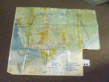
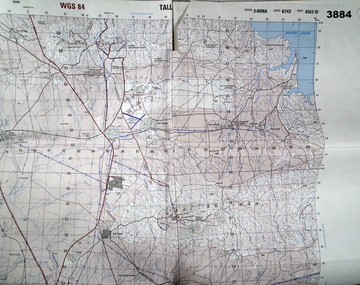
Map - MAP of IRAQ
Four topographical maps taped together of Tall Uwaynat and Tall Musa region of Iraq. Item belonging to Mathew Redwood. Refer Cat No 3891 for his service details.White paper, folded, four maps sticky taped togetherOrange fluoro marking out route taken by Australian forces in escort duties.maps, iraq -
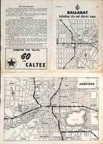 Ballarat Tramway Museum
Map, RACV - Royal Automobile Club of Victoria, "Ballarat including city and district maps", 10/1961
Shows the central part of Ballarat, Ballarat Outlets, streets, principal attractions, Ballarat and district maps and information. Has the tram lines shown dotted, does not run out to Sebastopol or the Lydiard St North terminus. Each map in the bottom left-hand corner has the number "1061", possibly indicating the date. Has notes on the City, points of interest, and an advertisement for Caltex. See item 4929 for a larger version dated 1966. Yields information about the extent of Ballarat in the early 1960's shows the tram lines and other rail lines in the district. Four fold map printed on white paper, titled "Ballarat including city and district maps" - Map No. MAP 15.314 and dated 10-61. Produced by the RACVmap, tranways, ballarat, racv, railways -
Whitehorse Historical Society Inc.
Map, City of Nunawading, 1973
Map showing streets, plot numbers, schools, open space and land usage.Map showing streets, plot numbers, schools, open space and land usage. A project by A Gray, student at Vermont High School. Area covered from Canterbury Road to Burwood Road and Terrara Road to Morack Road. Scale: 800 ft: 1 inchMap showing streets, plot numbers, schools, open space and land usage.vermont south, vermont, vermont high school, parks and reserves -
Bendigo Historical Society Inc.
Map - GOORNONG, 21/08/1888
Map: Parish of Goornong, County of Bendigo. Parish plan (number 345 in map cupboard 1)map, bendigo, parish plan, goornong -
Bendigo Historical Society Inc.
Map - EGERTON, 22/03/1892
Map: Parish of Egerton, County of Bendigo. Parish plan (number 343 in map cupboard 1)map, bendigo, parish plan, egerton -
Port Melbourne Historical & Preservation Society
Map - Port Melbourne, Department of Lands and Survey, 20 Sep 1932
Dept. of Lands and Survey Map Sheet 5 Port Melbourne, Parish of South Melbourne.Annotated re MHT precincts on foreshore:Plan sketches re boat harbourtown planning, sandridge lagoon, melbourne harbor trust - port of melbourne authority, transport - railways -
Moorabbin Air Museum
Map (Item) - RAAF Publication 103, Handbook of Administration in the RAAF
-
 Bayside Gallery - Bayside City Council Art & Heritage Collection
Map - print, Melbourne and Metropolitan Board of Works, Interim development order: Brighton, Moorabbin and Sandringham, 1959
The Melbourne and Metropolitan Board of Works (now Melbourne Water) was established in 1891. From that time, as part of their work laying water and sewerage connections, they created detailed plans of houses and other buildings in the Melbourne metropolitan area. In 1956 it acquired powers to construct and maintain highways and bridges, protect and improve the foreshores and create and maintain parks within the metropolitan region. This Interim development order comprises part of the municipalities of Brighton, Moorabbin and Sandringham and was made on 20 October 1959.brighton, moorabbin, sandringham, melbourne and metropolitan board of works, map, town planning, cartographic material, interim development order, bayside -
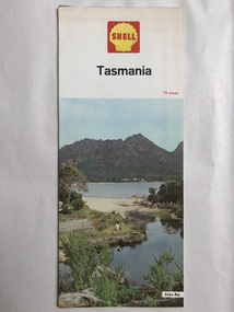 Robin Boyd Foundation
Map, Shell Touring Service, Tasmania
walsh st library -
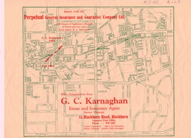 Whitehorse Historical Society Inc.
Map, Map of Mitcham, Nunawading and Blackburn, 1947
Map of Mitcham, Nunawading and Blackburn with compliments of G.C.Karnaghan, Estate and Insurance Agent of 15 Blackburn Road, Blackburn. Phone WX 1661 (4copies) Possibly 1947.g. c. karnaghan estate agent, perpetual general insurance and guarantee co. ltd., mitcham, nunawading, blackburn -
Melbourne Tram Museum
Map - Metlink folder - Travel Smart Maps, Travelsmart - Department of Infrastructure, "Melbourne's Public transport Map", 2005 to 2006
Set of four maps issued by Metlink - 2005 to 2006 contained within a Metlank badge plastic folder. Maps published in association with Melway 1 - 5 x 8 fold map with card cover dated Jan 2005 with a price of $2. Detailed map showing rail, tram and bus routes. 2 - 6 x 4 fold map for Moonee Valley - Travelsmart - for public transport, walking and cycling - dated 2005 3 - 7 x 4 fold map for Moreland - Travelsmart - for public transport, walking and cycling - dated October 2006 - includes notes on taxis. 4 - 7 x 4 fold map for Ride to Work day - 5 Oct. 2005Yields information about Melbourne Public Transport network.Metlink plastic folder containing maps.maps, metlink, public transport, moreland, moonee valley, travelsmart -
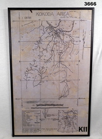 Bendigo Military Museum
Map - MAP, KOKODA MOUNTED, 2nd Aust Field Survey Section, 4.9.1942
Map was compiled from aerial photos without ground control or inspection & with information received from Major CAMERON.Laminated map of Kokoda area on board backing with black border. Black printing on cream / fawn background. White hanging strap on back. Information ledger bottom LHS. Kokoda inset bottom RHS.Printed at top: “KOKODA AREA” Printed at bottom “RHS: K11”map, kokoda, mounted -
Whitehorse Historical Society Inc.
Map, Mitcham Road, c1970
Enlarged aerial photo of the intersection of Mitcham and East Doncaster Roads, Mitcham. Scale 1 inch : 40 feet.Enlarged aerial photo, c1970, of the intersection of Mitcham and East Doncaster Roads, Mitcham. Scale 1 inch : 40 feet.Enlarged aerial photo of the intersection of Mitcham and East Doncaster Roads, Mitcham. Scale 1 inch : 40 feet.mitcham road, mitcham, quarry road, mitcham, doncaster east road, mitcham, wooddale grove, mitcham, mitcham primary school, no. 2904, aerial photographs -
Stawell Historical Society Inc
Map, T.F. McGauran, Winjallock County of Kara Kara, 1900
Noth of Navarre and BarkleyA2 Map0f Parish of Kara Kara.Photo Lithographed and the department of Lands & Survey, Melbourne by T.F. McCauran 22.10.00survey -
 Robin Boyd Foundation
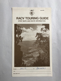
Map, RACV, Strip Maps Melbourne to Ballarat
walsh st library -
Whitehorse Historical Society Inc.
Map, Mitcham, 1880s?
Hand drawn map of area north and south of Whitehorse Road and South of Canterbury Road c.1880-1900.Hand drawn map of area north and south of Whitehorse Road and South of Canterbury Road c.1880-1900. Probably sketched by a McClare descendant. Includes locations and names of settlers of that time.Hand drawn map of area north and south of Whitehorse Road and South of Canterbury Road c.1880-1900. whitehorse road, mitcham, mitcham road, mitcham, l l vale road, vermont, canterbury road, mitcham -
Glenelg Shire Council Cultural Collection
Map - Map- Tarragal, n.d
Map - Tarragal - No further information supplied -
 Federation University Historical Collection
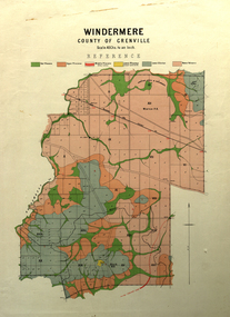
Map, Windermere, County of Grenville
Coloured geological map of Windermere, County of Grenville. Scale is 40 chains to 1 inchwindermere, grenville, krause, plan, map -
Bendigo Historical Society Inc.
Map - KAMAROOKA : COUNTY OF BENDIGO, 29-8-21
Map. Kamarooka, County of Bendigo, Milloo, Warragamba, Minto, Whirrakee, Tandarra, Piccaninny Creek, Dingee. By authority A.J. Mullett, Govt. Printer. Photo-Lithographed at the Department of Lands and Survey, Melbourne by W.J. Butson 29-8-21. Price 1/-. (number 63 in map cupboard 1)A.J. Mullett, Govt.Printermap, bendigo, kamarooka -
Glenelg Shire Council Cultural Collection
Financial record - Receipt - The Ocean Accident & Guarantee Corporation Ltd, 05/11/1926
Receipt from The Ocean Accident & Guarantee Corporation Ltd. to Mr. W. Vivian; renewal of policy premium £0:12:6, dated 5 Nov. 1926 -
 National Vietnam Veterans Museum (NVVM)
Map, Map of Area Surround Luscombe Airfield
Laminated map of military installations surrounding Luscombe Airfield. No identification of the map.luscombe field -
 Ringwood and District Historical Society
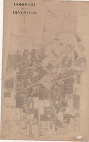
Map, Borough of Ringwood, Victoria - c.1950s
A0-size (approx) linen-backed municipal engineer’s survey map of named streets and lot-numbered properties within Borough of Ringwood.Scale: 8 chains to 1 inch. -
Canterbury History Group
Map - Township of Canterbury and Township of Balwyn, 1900
Copies of the maps of Canterbuy and Balwyn copied and enlarged from Sands and Mcdougall Directory 1900canterbury, balwyn, sands and mcdougall directories