-
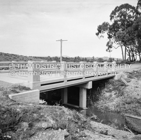 Eltham District Historical Society Inc
Negative - Photograph, J.A. McDonald, Healesville-Yarra Glen Road, Sep 1959
Long Gully Bridge after reconstruction September 1959Record of various Shire of Eltham infrastructure works undertaken during the period of 1952-1962 involving bridge and road reconstruction projects, sometimes with Eltham Shire Council Project Reference numbers quoted. It was during this period that a number of significant improvements were made to roads and new bridges constructed within the shire that remain in place as of present day (2022). In many situations, the photos provide a tangible visible record of infrastructure that existed throughout the early days of the Shire. The album was put together by or under the direction of the Shire Engineer, J.A. McDonald.infrastructure, shire of eltham, bridge construction, 1959-09, healesville-yarra glen road, long gully bridge -
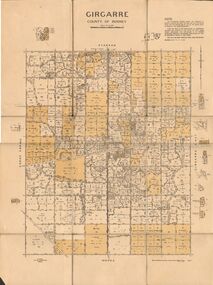 Bendigo Historical Society Inc.
Map - JACK FLYNN COLLECTION: GIRGARRE, 14/10/1943
Map: Parish of Girgarre. County of Rodney. Parish plan.By Authority, H.E. Daw, Government Printer Melbourne. Drawn and produced at the Dept of Lands and Survey, Melbourne, Victoria. 14.10.1943map, rodney, parish plan, girgarre, county of rodney -
 Eltham District Historical Society Inc
Negative - Photograph, J.A. McDonald, Eltham-Diamond Creek Road, May 1958
Bridge construction Eltham-Diamond Creek road over the Diamond Creek (Wattletree Road), Eltham, May 1958 Looking toward Eltham-Yarra Glen Road from Diamond Creek abutmentRecord of various Shire of Eltham infrastructure works undertaken during the period of 1952-1962 involving bridge and road reconstruction projects, sometimes with Eltham Shire Council Project Reference numbers quoted. It was during this period that a number of significant improvements were made to roads and new bridges constructed within the shire that remain in place as of present day (2022). In many situations, the photos provide a tangible visible record of infrastructure that existed throughout the early days of the Shire. The album was put together by or under the direction of the Shire Engineer, J.A. McDonald.1958-05, bridge construction, diamond creek (creek), eltham, eltham north, glen park bridge, infrastructure, shire of eltham, wattletree road bridge -
 Canterbury History Group
Map - Canterbury. Sale of the season, c1929
Photocopy of sale notice for 28 mansion and villa sites in area bordered by Kent Avenue, Mont Albert Road, Faversham and Chatham Roads 29 September [1929]canterbury, mont albert road, faversham road, kent avenue, chatham road, flere & co, land subdivision, auctions -
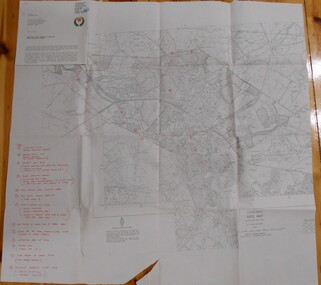
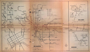 Melbourne Tram Museum
Map - Melbourne - Ballarat - Bendigo Tramways, 23-9-1969
Provides a detailed map of Melbourne, Ballarat and Bendigo tram lines - dated 23-9-1969. Shows street names, depot locations, depot layouts, track details including an insert for Sturt St Ballarat and destination locations. Provides a scale for each system. Not known who prepared the drawing.Yields information about the three operable Victorian systems at the date of preparation.Printed - dyeline? map on a folded sheet of papermap, melbourne, ballarat, bendigo, tramways, diagram -
Port Melbourne Historical & Preservation Society
Plan - Setting temporary gangway at Inner East berth Station Pier for Tasmanian ferry Abel Tasman, Engineering Division, Port of Melbourne Authority, 1984
Plan: cross section at passenger doors showing deck levels - ship full lowest allowable tide (Drawing used in the setting up of temporary gangway at the Inner East berth of Station Pier for the vessel Abel Tasman), 1984melbourne harbor trust - port of melbourne authority, piers and wharves - station pier, abel tasman -
Bendigo Historical Society Inc.
Map - AVAILABLE ALLOTMENTS, 10/08/1908
map: Available Allotments, Parishes of Whirrakee, Bagshot and Egerton, County of Bendigo. Parish plan (coloured) (number 330 in map cupboard 1)map, bendigo, allotments, available allotments, whirrakee, bagshot, egerton -
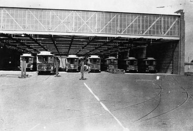 Melbourne Tram Museum
Negative, Wal Jack collection, early 1936
Negative of a photograph of the Brunswick Electric tram depot with many cable tram trailers in the depot, with body jacks in position, to load cars that had been sold onto a person's truck. Also one set of possibly cable bogies in front of car 191. Brunswick depot opened for electric cars on 26/4/1936. Trailers - Cable tram 457, 495, 486, 481, 191, 45 182 from the left. The Brunswick cable line was closed 11/1/1936 and Brunswick depot was opened 26/4/1936.Written on rear of album print - "Cable tram 457, 495, 486, 481, 191, 45 182 in the new tram sheds at Brunswick, now used for electric trams."trams, tramways, cable trams, brunswick depot, sale of trams, tram 457, tram 495, tram 486, tram 191, tram 45, tram 182 -
 Eltham District Historical Society Inc
Negative - Photograph, ‘Worlingworth’, Yarra River, Eltham
‘Worlingworth’, Yarra River, Eltham Original homestead on the property ‘Worlingworth’, a large residence and surrounding farm site standing on a knoll above the River Yarra in Banoon Road, Eltham. The present house was built about 1922 and was originally owned by Mr A.R. Read, a stock and station agent and member of the Stock Exchange (who left the district in early 1926 to take up permanent residence at his Warburton property). It became the home of notable anthropologist Prof. Dr. Donald Thomson (1901-1971) and Mrs. Gladys Thomson who were married in 1925 and had twin sons in 1934 and is considered historically and aesthetically significant to the Shire of Nillumbik.This photo forms part of a collection of photographs gathered by the Shire of Eltham for their centenary project book, "Pioneers and Painters: 100 years of the Shire of Eltham" by Alan Marshall (1971). The collection of over 500 images is held in partnership between Eltham District Historical Society and Yarra Plenty Regional Library (Eltham Library) and is now formally known as 'The Shire of Eltham Pioneers Photograph Collection.' It is significant in being the first community sourced collection representing the places and people of the Shire's first one hundred years.Digital image 4 x 5 inch B&W Negshire of eltham pioneers photograph collection, a.r. read, banoon road, donald thomson, eltham, gladys thomson, worlingworth, yarra river -
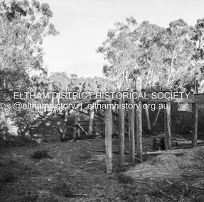
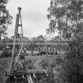 Eltham District Historical Society Inc
Negative - Photograph, J.A. McDonald, Eltham-Diamond Creek Road, May 1958
Bridge over Diamond Creek Pile driving Diamond Creek pier Bridge construction Eltham-Diamond Creek road over the Diamond Creek (Wattletree Road), Eltham, May 1958Record of various Shire of Eltham infrastructure works undertaken during the period of 1952-1962 involving bridge and road reconstruction projects, sometimes with Eltham Shire Council Project Reference numbers quoted. It was during this period that a number of significant improvements were made to roads and new bridges constructed within the shire that remain in place as of present day (2022). In many situations, the photos provide a tangible visible record of infrastructure that existed throughout the early days of the Shire. The album was put together by or under the direction of the Shire Engineer, J.A. McDonald.infrastructure, shire of eltham, 1958-05, bridge construction, wattletree road bridge -
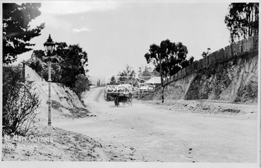 Eltham District Historical Society Inc
Negative - Photograph, Main Road, New Cutting Nearing Eltham, c.1908
Looking north from the corner of Bridge street The photo was possibly taken by John Henry Clark of Clark Bros Photographers who operated from 25 Thompson Street, Windsor near Prahan 1894-1914.This photo forms part of a collection of photographs gathered by the Shire of Eltham for their centenary project book,"Pioneers and Painters: 100 years of the Shire of Eltham" by Alan Marshall (1971). The collection of over 500 images is held in partnership between Eltham District Historical Society and Yarra Plenty Regional Library (Eltham Library) and is now formally known as the 'The Shire of Eltham Pioneers Photograph Collection.' It is significant in being the first community sourced collection representing the places and people of the Shire's first one hundred years.Digital image (x2) 4 x 5 inch B&W Negsepp, shire of eltham pioneers photograph collection, eltham, main road, gas lamp, street lamp, horse drawn vehicles, bakery, old bakery cottage, shillinglaw cottage, shillinglaw trees, clark bros. photo -
Bendigo Historical Society Inc.
Map - MARONG, 16/08/1881
Map: Parish of Marong, County of Bendigo. Parish plan (number 328 in map cupboard 1)map, bendigo, parish plan, marong -
 Bendigo Historical Society Inc.
Map - SANDHURST SHEET 2, March 12th 1867
Map: Sandhurst sheet 2 . Parish plan.map, bendigo, city streets, sandhurst, early bendigo -
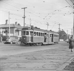 Ballarat Tramway Museum
Negative, Geoff Grant, 7/05/1955 12:00:00 AM
Negative No. 295 and colour print made by colour laser printer (stored in folder ) of W2 434 out bound on route 71, past the Camberwell Depot access tracks on 7/5/1955. Photo by Geoff Grant. Hi res scan of negative and image updated 19/5/2020.trams, tramways, melbourne, camberwell depot, tram w2 434 -
Bendigo Historical Society Inc.
Map - CAMPBELL COLLECTION: BENDIGO AND DISTRICT MAPS
Map. Bendigo & District. The same as 10104.1. The map is in a very damaged condition.map, bendigo, allotments -
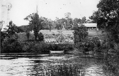
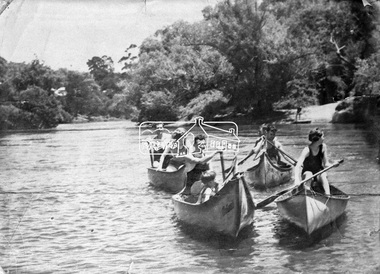 Eltham District Historical Society Inc
Negative - Photograph, Canoeing on the Yarra River at Warrandyte, Nov. 1934
This photo forms part of a collection of photographs gathered by the Shire of Eltham for their centenary project book,"Pioneers and Painters: 100 years of the Shire of Eltham" by Alan Marshall (1971). The collection of over 500 images is held in partnership between Eltham District Historical Society and Yarra Plenty Regional Library (Eltham Library) and is now formally known as the 'The Shire of Eltham Pioneers Photograph Collection.' It is significant in being the first community sourced collection representing the places and people of the Shire's first one hundred years.Digital image 4 x 5 inch B&W Negshire of eltham pioneers photograph collection, warrandyte, canoeing -
University of Melbourne, Burnley Campus Archives
Plan (Item), Repairs etc. to Caretaker's Cottage, Horticultural Gardens, Burnley Melb
Appears to be the cottage at the western end of the site, near the level crossing, occupied by the stockman (George Hudson ,followed by Tom Kennedy, then George Manley) Plan signed by J.B. McLean, District Architect, 24.1.33caretaker's cottage, burnley gardens, stockman's cottage -
 Federation University Historical Collection
Plan, Haddon, County of Grenville, 1932, 13/04/1932
The Haddon Parish Plan shows crown parcels government roads, Crown Reserves, Railway. Scale 40 chains to 1" (1:31, 680) WGS 84 Centroid Lat: 37 degrees 34' 00" S Long: 148 degrees 40' 20" E N.S. 9.3km E.W.: 16.1kmhaddon, grenville, cardigan, water supply reserve, nentingbook pre-emptive right, a. mclachlan, lake burrumbeet, e.a. wynne, p. russell, b. hepburn, benjamin hepburn, nentingbool, t.c. wilson, j. amoy, william collard smith, james roach, j. mitchell -
Bendigo Historical Society Inc.
Negative - CASTLEMAINE GAS COMPANY COLLECTION: NEGATIVES
4 strips of negatives in plastic pockets. They were inside envelope 11518.479. These negatives have not been scanned.negative, bendigo, gas and fuel -
Bendigo Historical Society Inc.
Map - NEILBOROUGH, 15/10/1877
Map: Neilborough, County of Bendigo. Parish plan (number 301 in map cupboard 1)map, bendigo, parish plan, neilborough, elysian flat -
Stawell Historical Society Inc
Map, Special Surveys, District of Ararat, 1869
Special Surveys, District of Araratstawell -
Moorabbin Air Museum
Plan (item) - Bristol Aeroplane 170 schematic drawings, Assy. of Web Doubler- Front Spar - Outer Wing
Bristol Aircraft Company Ltd -
 Kew Historical Society Inc
Plan - Subdivision Plan, Jas R Mathers Son & McMillan, The Dale Estate, Deepdene, 1918
Pru Sanderson, in her groundbreaking ‘City of Kew Urban Conservation Study : Volume 2 - Development History’ (1988), summarised the periods of urban development and subdivisions of land in Kew. The periods that she identified included 1845-1880, 1880-1893, 1893-1921, 1921-1933, 1933-1943, and Post-War Development. These periods were selected as they represented periods of rapid growth or decline in urban development. An obvious starting point for Sanderson’s groupings involved population growth and the associated economic cycles. These cycles also highlighted urban expansion onto land that was predominantly rural, although in other cases it represented the decline and breakup of large estates. A number of the plans in the Kew Historical Society’s collection can also be found in other collections, such as those of the State Library of Victoria and the Boroondara Library Service. A number are however unique to the collection.The Kew Historical Society collection includes almost 100 subdivision plans pertaining to suburbs of the City of Melbourne. Most of these are of Kew, Kew East or Studley Park, although a smaller number are plans of Camberwell, Deepdene, Balwyn and Hawthorn. It is believed that the majority of the plans were gifted to the Society by persons connected with the real estate firm - J. R. Mathers and McMillan, 136 Cotham Road, Kew. The Plans in the collection are rarely in pristine form, being working plans on which the agent would write notes and record lots sold and the prices of these. The subdivision plans are historically significant examples of the growth of urban Melbourne from the beginning of the 20th Century up until the 1980s. A number of the plans are double-sided and often include a photograph on the reverse. A number of the latter are by noted photographers such as J.E. Barnes.The Dale Estate in Deepdene was made possible by the death of Robert Sparrow Smythe, Australian journalist, newspaper editor/owner and theatrical manager. Smythe lived in his residence ‘Highate’, Deepdene until his death in 1917. In the subdivision proposed one year later, before the end of the First World War, 18 allotments were to be created. The very fragmentary plan in the Society’s collection notes that a large weatherboard [house] will need to be removed. This may be Smythe’s own home. The proposed subdivision included allotments facing Burke and Whitehorse Roads and Dale Street. Bordering the subdivision is the Deepdene Station and the Outer Circle Railway Line. The clear directions on the plan indicate that in 1918 it was possible to travel by train from Deepdene to East Camberwell and Ashburtonsubdivision plans - deepdene, the dale estate -
 Bendigo Historical Society Inc.
Negative - TOM PATULLO COLLECTION: COBB & CO, BOOKING OFFICE
Negative Print. Cobb & Co. Booking Office, K. Van Damme Tobacconist. Pall Mall, Bendigo. Also found in Box 87-2402.17.cottage, miners, cobb & co, booking office., cobb & co, booking office. -
 Bendigo Historical Society Inc.
Map - BENDIGO HISTORICAL SOCIETY COLLECTION: EAGLEHAWK MINE MAP
Base map Australian map grid of Eaglehawk area. Map has letter attached from the Department of Conservation, Forests and Lands, 22 March, 1990, addressed to Felicity Kingerlie, BHS, requesting information regarding the historic mining sites marked on the map. Sites marked are: A. Golden Age Mine, engine mountings present B. Johnson's No. 2 Mine, engine mountings, old boiler foundations C. Johnson's No. 1 Mine, mullock retaining wall made from sandstone, engine mountings, remains of old building demolished? D. Toma's Eucalyptus Factory, old boiler still there, boiler shed, chimney (remnants of) outlet drain, distilling vats, dam, remnant of winch. E. New Argus Mine,mullock heap F. New Moon Mines Dams (1) stone walls G. North Lightning Hill Mine, engine mountings, quartz retainer wall, Pascoe and Simmons open cuts and other open cuts here too H. New Prince of Wales Mine and Poppet Head I. Quarry site for stone, excavation (for miners cottages in Clarke Street) J. Lancashire open cut mine K. Virginia Hill (cynaide vats etc) L. South Prince of Wales mine, now capped and fenced M (possibly ) Catherine United Mine, engine mountings, battery mountings?bendigo, mining, eaglehawk mines -
Wonga Park Community Cottage History Group
Negative (Item) - Negative of a photo, Mrs. Sharpe in her horse-drawn cart, 1919, at the corner of Jumping Creek and Hartley Roads
-
Port Melbourne Historical & Preservation Society
Plan - Annotated and handcoloured by Peter Libbis to indicate his research into Libbis family residences and hotels on copy of a section of an MMBW map, Melbourne and Metropolitan Board of Works, c. 1980s
Peter LIBBIS obtained these copies from the MMBW when he researched his family history in the 1980s. He has annotated them, colour in hotels etc. Donated to Society in 1997.One of a group of 19 photocopies of various 20th century MMBW plans, annotated/coloured in to indicate residences of Libbis family and local hotels, by Peter LIBBIS in family and hotel research - Boundary to Ingles Street (South Melbourne mostly)business and traders - hotels, built environment - domestic, transport - railways, melbourne and metropolitan board of works, libbis family -
Glenelg Shire Council Cultural Collection
Map - Map - Bridgewater Lakes Tour, 1970s
Typed up directions around the Bridgewater area. Inside: Map of Portland - Bridgewater area.map, tourism, travel, recreation, cape bridgewater -
Whitehorse Historical Society Inc.
Map, Plan of the Parish of Nunawading, 1853
Photocopy of map showing names of selectors, also list of references to the corners of allotments.Photocopy of map showing names of selectors, also list of references to the corners of allotments. Note on verso:'Gardiners Creek, Ballyshanassey township surveyed by H. Parmein, Surveyor General's Office Nov 30, 1853 also Reference to the Corners of allotments' (Plan 428)Photocopy of map showing names of selectors, also list of references to the corners of allotments. land subdivision, gardiners creek, ballyshanassy, parmein, h, burwood east, maps -
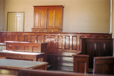 Eltham District Historical Society Inc
Negative - Photograph, Harry Gilham, Interior, Eltham Courthouse, 730 Main Road, Eltham, Sep 2004
The cupboard (containing 48 pigeon holes) was moved from Clerk's Office to 'block' the fireplace behind the Magistrate's bench in 2004eltham courthouse