Showing 4711 items
matching documentation
-
 Bendigo Historical Society Inc.
Map - PARISH OF SANDHURST 1961, 1961
At Bendigo Parish of Sandhurst. Sheet 13Dept of Lands and Surveybendigo, land sales, parish map -
 Robin Boyd Foundation
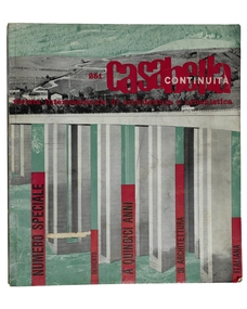
Journal, Casabella Continuita, No. 251, May-61
Boyd article: ‘Architetta Italiana e Romande’ pp.8 -9. Shortened English version of Boyd article included in "Translations and Digests" insert. This Journal features the direction of contemporary italian architecture. It is a rare copy of the journal.architecture, italian architecture, aldo rossi, pier luigi nervi, italy, walsh st library -
 Federation University Historical Collection
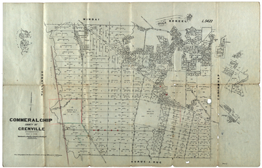
Plan, Commeralghip, County of Grenville, 1905, 03/02/1905
The Township of Kaleno is in the Pitfield Plains. The Cape Clear Cemetery T contains the graves of miners and local pioneering families from the Cape Clear, Hollybush, Kaleno, Pitfield Plains, Pitfield, Illabarook, Berringa, Springdallah, Wallinduc, Glenfine, Happy Valley and Western Creek districts.Plan of allotments in Commeralghip, County of Grenville, Victoria. The plan includes the township of Kaleno, Dereel Pre-Emptice Right (John Cullen), Commeralghip Pre-Emptive Right (John Gordon McMillan and Glenfine Pre-Emptive Right (William Rowe). It also includes landholders such as Robert mcPherson, C. Cameron. John Boyd, John Cullen, W.T. Rowe, George Currie, J.P. Mackay, T. McCaffery, G. Hawkins, Alexander McPherson, C. Cameron. Gift of the Squire Family, 2014commeralghip, pitfield plains, kaleno, dereel, glenfine, squire, richard squire, w.t. rowe, john cullen, alexander mcpherson, george currie, mt misery, william rowe, mindai, john gordon mcmillan -
 Federation University Historical Collection
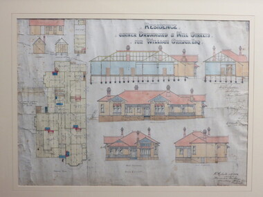
Plan - Architectural Plan, Architectural Drawing of 222 Drummond Street North, Ballarat, 1904, 1904
Perceval Selwyn Richards (ARVIA) was a Ballarat architect who from 1900 to 1940 was responsible for innovative Edwardian and Art Deco style buildings in the district. In 1904 his office was at the Mercantile Building on the corner of Armstrong and Dana Streets, Ballarat. Perceval Selwyn Richards was born 21 July 1865 at Christchurch, New Zealand. He married Alice Emma Nicholson. Percy Richardson sailed to Melbourne, Australia in 1887 to find employment in an architect’s office. On arrival in Ballarat started as an assistant in the architectural firm of William Brazenor, where he worked for six years before continuing with the business after Brazenor's death. He taught Architecture at the Ballarat School of Mines from 1918 to 1921. As well as his work from the Ballarat and District Anglican Diocese and the Ballarat and the Western Districts. Ballarat & Clarendon College is also one of his designs. Framed original architectural by Percival Richards of 222 Drummond Street North, Ballarat, on the corner of Mill Street.perceval richards, percy richards, architecture, ballarat, drummond street noirth, cappell, dobson, w.a. cappell, mary cappell, mary dobson, tom cappell, robert r.g. dobson, alexander edward, cant, n. wellington, william orrack -
 University of Melbourne, Burnley Campus Archives
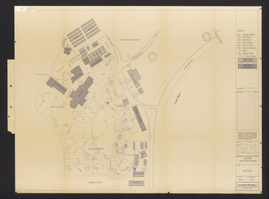
Plan, Burnley Horticultural College: Site Plan, 1983-1984
Plans of the Burnley Campus, Ornamental Gardens from Plan 11.0715 by Alexander Metherell Pty. Ltd. Dated November 1983. Scale 1:500. (1) 5 copies, buildings shaded showing construction type. Job No BHC/1 Drawing No SP/1. Tree placements stamped on, includes legend. (2) 2 copies No SP/1c. In Description column, "A" Building Names 7/02/1984. Also see B15.0352 full report. B11.0715 originals. B11.0599 SP/3.ornamental gardens, burnley campus, burnley horticultural college, alexander metherell p/l -
Bendigo Historical Society Inc.
Map - TOWNSHIP OF SANDHURST MAP
Map township of Sandhurst Portion B Bendigo Creek. Victoria zincographed at the Crown land's office, nos 54/21-57/12 Melbourne, April 21st 1857 (by G. Collis). -
Glenelg Shire Council Cultural Collection
Map - Map - RACV Road Map, 1970s
RACV road map, Warrnambool District, Port Fairy to Lorne. Large coloured map of Warrnambool District. Small maps of Apollo Bay, Colac, Camperdown, Tower Hill and Warrnambool. When folded, black and white photo on cover of 12 Apostlesracv, road touring, road map, victoria -
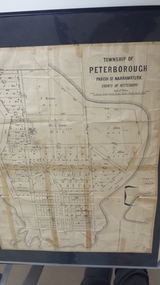 Peterborough History Group
Map - Map of the township of Peterborough, Township of Peterborough
Undated but indicative of the layout of the town. includes printed notes regarding the landscape and flora.Old map of the township of Peterborough from J S Irvine.A3 size paper map with tape around the sides. Includes handwritten notes.Handwritten on the rear is J.S Irvinepeterborough, old maps -
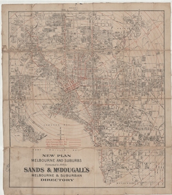 Melbourne Tram Museum
Map, Sands McDougall, "New plan Melbourne and Suburbs Sands & McDougall's Melbourne and Suburban Directory", 1910
Shows railways, horse, cable and electric tram lines c1910. One of a number of maps produced by Sands McDougall of Collins St. Includes the MTOCo zoo horse tram lines, the NMETL and VR lines, but not the PMTT. Includes the Caulfield Elsternwick horse tram lines. Possibly included in Sands and McDougall directories based on the title. See items 2885, 6573 and 6916 for other editions. Yields information about Melbourne c1910 and its public transport lines. Cloth-backed and folded sheet of paper 5 sections wide x 4 sections or folds deep. Produced by Sands and McDougall Pty Ltd of Collins St Melbourne. maps, melbourne, cable trams, tramways, railways, horse trams, nmetl, vr trams, sands mcdougall, zoo horse tramway -
Bendigo Historical Society Inc.
Map - NERRING : COUNTY OF BENDIGO, August 1952
Map. Nerring, County of Bendigo, Leichardt, Marong, Sandhurst, Huntly, Neilborough, Yarraberb. Drawn and Reproduced at the Department of Lands and Survey, Melbourne, Victoria, August 1952, Price 2/-.( number 409 in Map Cupboard 1).J.J. Gourley, Government Printer, Melbourne.bendigo, hospital -
Bendigo Historical Society Inc.
Map - PORTION OF SANDHURST, 27/01/1877
Map: Hand draughted parish plan, showing a portion of the City of Sandhurst ( number 225 in Map Cupboard 1)map, bendigo, parish plan, sandhurst -
Whitehorse Historical Society Inc.
Map, City of Nunawading map, 1970s (post 1974)
Catchment area of Blackburn East Primary School.Catchment area of Blackburn East Primary School marked in texta on map of the City of Nunawading. Scale: 1 km:6 kmCatchment area of Blackburn East Primary School. city of nunawading, blackburn east primary school no. 4800 -
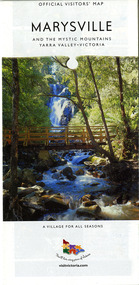 Marysville & District Historical Society
Map (Item) - Map and touring guide, Murrindindi Regional Tourism Association Inc, MARYSVILLE AND THE MYSTIC MOUNTAINS YARRA VALLEY-VICTORIA, Unknown
A fold out map and touring guide of Marysville and the surrounding district published by Murrindindi Regional Tourism Association Inc.A fold out map and touring guide of Marysville and the surrounding district published by Murrindindi Regional Tourism Association Inc.marysville, victoria, australia, map and touring guide, the cumberland, murrindindi regional tourism association inc, abbey green b&b, amberview lodge, anastasia fairytale cottage, ashlar cottage b&b, blackwood cottages, camellia log cabin, crossways country inn, dalrymples guest cottages, eagle mountain retreat, esa camping and conference centre, fruit salad farm, gilberts restaurant, keppels hotel motel, kerami house, kooringa resort and conference centre, lomatia lodge, lyelll guest cottages, marylands country house, marylyn holiday resort, marysville caravan park, marysville visitor information centre, alpacas at carmyle farm, australian adventure experience, bruno's art and sculpture garden, buxton trout farm, country touch tours, lake mountain, lake mountain ski hire, manical mechanicals, marysville district country club, marysville ski centre, rubicon valley horse riding, things of sand & stone, clearstream olives, the old woolshed cafe, fraga's cafe restaurant, lake mountain resort bistro, mantirri blueberry farm, gallipoli park, keppels lookout, cambarville, lady talbot drive, cathedral range state park, steavenson falls, steavenson river, taggerty river, acheron river, marysville auto and hardware, marysville newsagency & general store, narbethong visitor information centre, visit victoria -
Bendigo Historical Society Inc.
Map - LANSELL'S BIG 180 MINE - LOCALITY OF LANSELL'S NO 180 SHAFT
Buff coloured photocopy of the location of Lansell's No 180 Shaft and showing the positions of Underground Workings near the intersection of Lily St and Alley St. Also mentioned are the North Old Chum Shaft and the New Chum and Victoria Co Shaft. Luffman Brothers has been written in in pen and initialled A R. Printed at the bottom is: Surveyed by E. T. Brown, under the direction of A. W. Howitt, Secretary for Mines for the - (the rest is cut off).map, bendigo, mining plan, lansell's big 180 mine, locality of lansell's no 180 shaft, north old chum co shaft, new chum and victoria co shaft, luffman brothers, e t brown, a w howitt -
Kew Historical Society Inc
Plan - 30 Choice Home Sites in Kilby Road, Meldrum Street and Fairway Drive, 1965
Subdivision plans and real estate flyers/brochures reveal a number of aspects of urban development and history. The Kew Historical Society's collection of these plans, as well as advertisements extracted from magazines, cover key aspects of community development and architectural history of Kew and Kew Eat as well as surrounding suburbs. While most of the plans in the collection were gifted to the Society by the former City of Kew, a number of other plans and advertisements have been donated by individuals, of which this is an example.Original 4-page, bifold brochure, one of two in the collection, of home sites created following the creation of the Eastern Freeway which separated a section of land owned by the Kew Golf Club from the main course. The new estate featured 30 lots in Meldrum Street, Kilby Road and Fairway Drive. subdivisions -- kew east (vic.), subdivisions -- kew (vic.), kew golf club -
Whitehorse Historical Society Inc.
Map, Subdivision of Allotment 122a, 1972
Subdivision of land along Livermore Close and Moore Road, Vermont South.Subdivision of land along Livermore Close and Moore Road, Vermont South. Original survey Rob Poole 1899. Stamp indicates 'Land on this plan is in proclaimed survey No 21. Survey Coordination Act 1940. As from 9 Aug 1972. Two maps in different scales.Subdivision of land along Livermore Close and Moore Road, Vermont South. land subdivision, livermore close, vermont south, moore road, vermont south, dandenong creek -
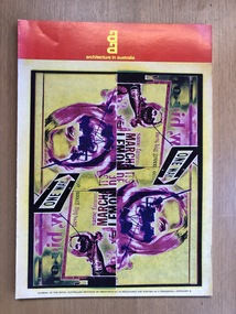 Robin Boyd Foundation
Journal, John C. Oostermeyer, Architecture in Australia, 1973
Softcover, Magazineaustralian architecture, walsh st library -
Bendigo Historical Society Inc.
Map - HUSTLERS LINE OF REEFS - LONGITUDINAL SECTION THROUGH THE SADDLE REEFS
Drawing with Longitudinal Section through the Saddle Reefs along portion of Hustler's Line of Reefs, Bendigo. Map shows the depth of the mines, reef numbers and Datum 700 ft above sea level. North and South is also noted on the map. Map signed by H. S, Whitelaw, Underground Survey Office, Bendigo, September 1913. Bulletin No 33, Plate No XXXIV. Bendigo Creek, Ironbark Creek and Long Gully are also noted. Mines are: Fortuna Hustlers, Hustler's Royal Reserve No 2 Main Shaft, Hustler's Royal Reserve No 2 Park Shaft, Royal Hustler's, Imperial Hustler's, Extended Hustler's Freehold, Great Extended Hustler's Tribute (Pups), Old Shaft, Great Extended Hustler's Reef No 2, Great Extended Hustler's Main Shaft, Old Shaft, Hustler's Reef, Hustler's Reef No 1, Comet, K. K., United Hustler's & Redan, Old Shaft and Hustler's Consols. Has Geological Survey of Victoria Crest and underneath is: H. Herman, Director, W. Dickson, Secretary for Mines, The Hon. J Drysdale Brown M L C. Minister of Mines.Geological Survey of Victoria Crestmining, parish map, hustler's reef maps, hustlers line of reefs, bendigo creek, ironbark creek and long gully are also noted. mines are: fortuna hustlers, hustler's royal reserve no 2 main shaft, hustler's royal reserve no 2 park shaft, royal hustler's, imperial hustler's, extended hustler's freehold, great extended hustler's tribute (pups), old shaft, great extended hustler's reef no 2, great extended hustler's main shaft, old shaft, hustler's reef, hustler's reef no 1, comet, k. k., united hustler's & redan, old shaft and hustler's consols.h s whitelaw, underground survey office bendigo september 1913, bulletin no 33 plateno xxxiv, mi -
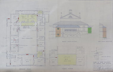 Federation University Historical Collection
Plan, School of Mines Ballarat Old Supreme Court Building, 1959, 26/10/1959
Copy of a plan and elevations of the former Ballarat Supreme Court, later a building of the Ballarat School of Mines. The plans were for repairs and painting of the Old Electrical School of the Ballarat School of Mines. former ballarat supreme court, electrical school, ballarat school of mines, painting -
 Federation University Historical Collection
Map, Lintons Pre-emptive Section, 1872, 1872
Printed map with coloured shading by F. W Niven Lydiard Street, Ballaratmap, mining districts, lintons claim, lintons diggings, f w niven, nivens steam lithographic machine, f.w. niven -
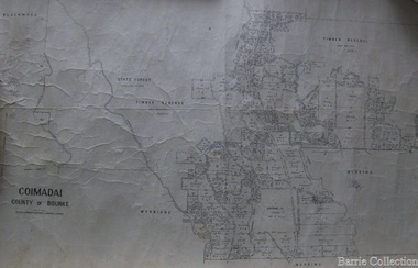 Melton City Libraries
Map, Coimadai County of Bourke, 1911
Town Plan of Meltoncouncil -
 Federation University Historical Collection
Plan, City of Ballarat (Part) (Ballaarat East), 08/05/1928
Crown Cadastral Plan showing Governement Roads, Crown Parcels, Dimensions, Crown grantees, dated of grants, etc in Ballarat East. The plan shows features such as Bakery Hill, Canadian Station, recreation reserves, timber reserves, Yarrowee Creek, Black Hill Reserve, Eureka Reserve and Garden, Orphan Asylum, Rifle Butts Reserve, Ballarat Woollen Mill, Ballarat Observatory, Sovereign Hill Recreation Reserve, Specimen Vale, Market Reserve, Cemetery WGS 84 Centroid 37 degrees 33' 55" S 143 degrees 52' 38" E E.W. Extent; 5 km N-S Extent; 4 kmmap, plan, ballarat east, ballarat woollen mill, ballarat railway line, ballarat railway station, eureka reserve, eureka cemetery, ballarat orphanage, russell square, bakery hill -
Moorabbin Air Museum
Plan (item) - Couguar Turbojet Engine 022-010A - GAF
-
University of Melbourne, Burnley Campus Archives
Plan, Burnley College Site, c. 1990
Miscellaneous plans of the Burnley site with enlargements of sections. Roughly sorted. Different periods.burnley college, gardens -
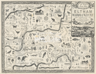 Eltham District Historical Society Inc
Map, George W. Bell, A Visitor's Guide Map; ELTHAM, WARRANDYTE and Environs, c.1969
Commissioned by George W. Bell, designed by Anthony Harvey. An old gold mining and wine growing district eighteen miles from Melbourne, now notable for its arts, crafts, good food and historic buildings. On the reverse side (of one copy only) is printed in 8 panels (3 half-folds) advertising for Montsalvat, Eltham; Setel Downs Coffee Kitchen Art Gallery, Kangaroo Ground; Country Art Store, Eltham; Alfred's Homestead, Warrandyte; Neville F Emmerson Estate Agent, Lower Plenty; Eltham Crafts. Monstsalvat, Eltham; Tantoon native plants and culinary herbs, Eltham; Flavour of Eltham, Shillinglaw Coattage Preservation Society; The Eltham Barrel; Potters Cottage, Warrandyte. In addition is provided by cateogory listing: POTTERY AND CRAFTS Country Art Store, Eltham Diamond Creek Handicrafts, Diamond Creek Eltham Crafts, Eltham John Mills, Eltham Potters Cottage, Warrandyte Setel Downs, Kangaroo Ground The Claypot, Warrandyte Warrandyte Quarries and Pottery, Warrandyte GOOD FOOD AND DRINK Alfred's Homestead, Warrandyte Geranium Parlour,. Research Inglenook, Warrandyte La Ronde, Eltham The Barrel, Research The Potters Restaurant, Warrandyte Setel Downs, Kangaroo Ground GALLERIES Hassall's Gallery, Research Lodge Gallery, Warrandyte The Bird Gallery, Eltham Royalat Gallery, Panton Hill PLANTYS, TREES AND SHRUBS Danson's Gardens, Research Dean's Orchids & Dahlias, Templestowe Diamond Vlley Trees & Shrubs, Warrandyte Jum Jum, Diamond Creek Parson's, Research Tantoon, Eltham Warran Glen, Warrandyte44..8 x 57.5 cm (Two copies) On the reverse side (of one copy only) is printed in 8 panels (3 half-folds) advertisingeltham, warrandyte, map, country art store, diamond creek handicrafts, eltham crafts, john mills, potters cottage, setel downs, the claypot, warrandyte quarries and pottery, alfred's homestead, geranium parlour, inglenook, la ronde, the barrel, the potters restaurant, hassall's gallery, lodge gallery, the bird gallery, royalat gallery, danson's gardens, dean's orchids & dahlias, diamond vlley trees & shrubs, jum jum, parson's, tantoon, warran glen, advertising, eltham barrel -
 Wodonga & District Historical Society Inc
Map - Australia Shewing the Tracks of the Late Explorers, c1865
Charles George Eastland Platts arrived in South Australia on 22 March 1839, and soon after established his business in Adelaide. He became Adelaide’s first bookseller. It was known as Platts’ Library but was also a bookshop and stationer. His business was also used as a postal receiving house. Platts died on 14 November 1871. Boyle Travers Finniss (18 August 1807 – 24 December 1893) had an early career in the British Military before selling off his commission in 1835. He was appointed assistant surveyor to Colonel William Light in South Australia. He then had several roles in public service. Finniss was the first premier and Chief Secretary South Australia, serving from 24 October 1856 to 20 August 1857. In 1864 he was appointed as the Government Resident of the Northern Territory. He was filling this role at the time when the map was produced and is acknowledged on the map.This is a very early map documenting the exploration and opening up of Australia.Map of Australia and part of Indonesia. Part coloured with tracks of 15 explorers including Eyre, Stuart, Leichhardt and Burke and Wills with notes and some details of latitude and longitude. Relief relating to the major mountain ranges is indicated. At the bottom of the map is a key to the explorers and a list of the counties in the different states. Top left side of map has small sketch of the Platts (publisher) building at the corner of King William Street.Map of Australia shewing the tracks of late explorers into the interior and across the continent together with their discoveries map/ projected, compiled and drawn by O.W.O. Bennett Most Respectfully Dedicated to LIEUT. COL. BOYLE TRAVERS FINISS Government Resident of the Northern Territory of SOUTH AUSTRALIAexplorers -- australia -- maps, rare maps australia -
Whitehorse Historical Society Inc.
Map, Eastern Freeway Extension, 2002
Extension of Eastern Freeway: Plan of Deep Creek Road paths, drainage and alignment plan.Extension of Eastern Freeway: Plan of Deep Creek Road paths, drainage and alignment plan.Extension of Eastern Freeway: Plan of Deep Creek Road paths, drainage and alignment plan.deep creek road, mitcham, eastern freeway extension, eastlink -
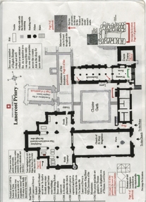 Ballarat Heritage Services
Plan, Lanercost Priory, Digital copy made 2016
Lanercost Priory was founded around 1169 by Robert de Vaux, and was home to an order of Augustinian canons until 1538 when is was dissolved by Henry VIII. In 1542 the priory and lands were granted to Thomas Dacre, an illegitimate son of Thomas, Lord Dacre. Mason's marks can be found throughout the undercroft. Plan on white paper with black and red ink printing and a drawingEnglish Heritage Lanercost Priorymason's marks, marks, stone marks, stonemasons, lanercost, priory, plan, 1169 -
Bendigo Historical Society Inc.
Map - CALIVIL : COUNTY OF BENDIGO, 12-12-22
Map. Calivil, County of Bendigo, Mologa, Jarklan, Pompapiel, Talambe, Hayanmi. Calivil Creek, Seven Months Creek. Photo-Lithographed at the Department of Lands and Survey, Melbourne by W.J. Butson,12-12-22, Price 1/-. By authority A.J. Mullett, Government Printer, Melbourne. (number 56 in map cupboard 1)A.J. Mullett, Government Printer, Melbourne.map, bendigo, calivil -
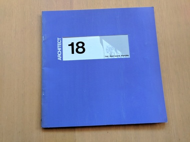 Robin Boyd Foundation
Journal, Neil Clerehan, Architect: Issue 18, 1972
Soft Cover Magazinearchitecture, australian architecture, walsh st library