Showing 2265 items in the category Documentation with item type Map
-
 Port Melbourne Historical & Preservation Society
Map - County of Bourke, Thomas Bibbs, 1866
Map of the County of Bourke, 1886melbourne -
Whitehorse Historical Society Inc.
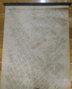
Map, Parish of Nunawading, 1927
Map of the Parish together with part of the Borough of Box Hill.Map of the Parish together with part of the Borough of Box Hill. Includes names of lease or license holders, sizes of leases and in some areas dates of leases. Roads, railway and stations marked. Original survey by W.J.Busocon, 1915. Manuscript note: 15.2.1927 Verified Dept. Lands and Survey.Map of the Parish together with part of the Borough of Box Hill. maps, parish of nunawading, borough of box hill -
 Ballarat Tramway Museum
Map, South Pacific Electric Railway, c1970's
702.1 Map of Sydney Trams - diagrammatic in 1921, includes electric and steam, shows streets, railways and where starting (Not original a reproduction) 702.2 - as above, but shows track layout, crossovers etc. - more to scale, also a reproduction. Image added 20-12-2016.trams, tramways, map, sydney -
Bendigo Historical Society Inc.
Map - HARCOURT, December 1951
Harcourt, County of Bendigo, Walmer, Castlemaine, Sutton Grange. Mt.Alexander Trig. Station, Barkers Creek, Faraday, Calder Highway, Northern Railway. By Authority J.J.Gourley, Government Printer, Melbourne,Drawn and Reproduced at the Dept. of Lands and Survey, Melbourne, Victoria. December 1951. Price 5/-per sheet. (number 35 in map cupboard 1)J.J.Gourley, Government Printer, Melbourne.map, bendigo, harcourt -
 Bendigo Historical Society Inc.
Map - CITY OF SANDHURST RESURVEY SHEET 1, 21/05/1881
Map: City of Sandhurst resurvey sheet 1. Parish plan showing the Southeastern corner of the Municipalitymap, bendigo, parish plan, sandhurst, resurvey -
 Bendigo Military Museum
Map - EASTER NEW GUINEA NAVIGATION CHART, RAAF, Aug 1943
From the collection of "Maxwell Lennox Matheson" No.418447 RAAF. Enlisted 22/5/1942 Aged 19. Discharged 19/2/1948 - Rank FLTLT.This map is in colour. It is made of a stiff paper and has a map printed on both sides. Side1 - scale 1:2,315,000. 31.72 Nautical miles = 1 inch. It shows Eastern half of New Guinea. It also shows New Britain and New Ireland. Manus Island is at the top. Side 2 - Scale 1:1,000,000 - this shows Manus Island on right side, top of New Guinea at bottom edge (Wewak) and some other little islands. The map on side 1 has numerous navigation tracks and calculations in pencil. i.e. LAE, KOKODA, PORT MORESBY.ww2, raaf, new guinea -
 Ringwood and District Historical Society
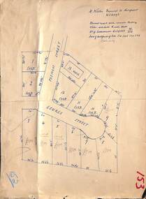
Map, Subdivision Plan - House and 13 residential allotments fronting Fremont Street Ringwood, Vic., and George Street (later Tudor Court), Heathmont, Vic. - Undated, circa 1922
Hand-drawn map on cardboard backing.Formed road with concrete kerbing. Water available to each block. No. of subdivision A139880 73/419. Part of Certificate of Title Vol 5323 Fol 539. Real estate sales notations on some allotments include price. Heading also includes address and phone number of H. Willis, Fremont Street Ringwood - WU6073. -
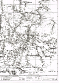
 Ballarat Tramway Museum
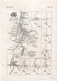
Map - "Geelong tramways", Ken McCarthy, 1981
Map titled "Geelong tramways" prepared by Ken McCarthy Feb. 1981 showing the Geelong tram system with major street names, with a service frequency chart for weekdays in 1951 and 7 small maps showing the various stages of system development from 1912 to 1940. Has an insert for the depot layout. Produced for Ken's article on Geelong Tramways in the April 1981 issue of Trolley Wire, published by the Sydney Tram Museum.Yields information about the Geelong tram system and has a close association with Ken McCarthy.A4 printed sheet - from the April 1981 issue of Trolley Wire magazine.tramways, geelong, map, trolley wire -
 Whitehorse Historical Society Inc.
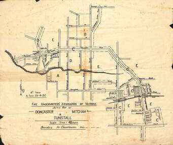
Map - Fire Underwriter's Association Sketch Map, Fire Underwriter's Association of Victoria, Doncaster, Mitcham and Tunstall, 29/4/1932
Shetch map of Doncaster, Mitcham and Tunstall. Scale 1inch = 40 chainsA sketch map of Doncaster, Mitcham and Tunstall by the Fire Underwriters' Association of Victoria.non-fictionShetch map of Doncaster, Mitcham and Tunstall. Scale 1inch = 40 chainsmap, doncaster, mitcham, tunstall -
 Bendigo Historical Society Inc.
Map - SPRING PLAINS, Examined 31/01/1876
Map: Parish of Springplains, County of Dalhousie. Parish plan June 1874 A.D. Scott Examined E.D. 4.7.74 Additions made March 1877 Written in blue " See new plan."map, dalhousie, parish plan, spring plains, a. d. scott -
 Robin Boyd Foundation
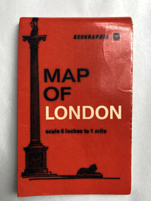
Map, Geographia, Map of London
walsh st library -
 Melbourne Tram Museum
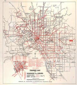
Map, "Tramway Map of Melbourne and Suburbs", c1950
Map of Melbourne's Tram and Bus routes, route destinations, all-night bus routes, depots, golf links and sporting grounds, rail lines, and location of major places of interest. Titled - "Tramway Map of Melbourne and Suburbs" - c1950, after the La Trobe or Latrobe St lines opened. Not known who produced the map. Does not give route numbers. See also Reg Item 2300 for an MMTB Map of the same era, 3720 for a similar version with the MMTB guest houses shown, and 4525.1 for an MMTB Photograph.Yields information about Melbourne tram routes prior to Bourke St being built.Fold out map (6 sections), two colours. Has been removed from a book with the remnants of other paper in the top left-hand side.has "1950" in top left hand corner in ink.trams, tramways, melbourne, map, tram & bus services, all night services, mmtb -
Port Melbourne Historical & Preservation Society
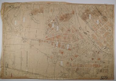
Map - MMBW, c. 1894
Melbourne and Metropolitan Board of Works 1894, Plan number 18 Segments Shown: Between 322 - 486 Smaller scale map incorporating piers, lagoon and town north to beyond boundaryIn pencil: "7/7/94" (Which is the copyright date)engineering - board of works, piers and wharves - railway pier, piers and wharves - town pier, sandridge lagoon, transport - tramways, transport - railways, gasworks, built environment -
University of Melbourne, Burnley Campus Archives
Map, City of Kew, Hyde Park, c. 1970
(1) Photocopy of hand drawn plan of park showing contours. No 7/3. Scale 1 inch:40 ft. (2) Map 45 from Melway with Hyde Park highlighted.kew, hyde park -
Stawell Historical Society Inc
Map, Stawell Gold Mines, Stawell Township 1995, 1995
Map shows details of mining activity Stockpiles, Tracks, Plant, Dams,, Waste, Tailing Dams, IronbarksPlain Printed Map in Black & White with details of MiningStawell Gold Mines Pty Ltdmining -
Bendigo Historical Society Inc.
Map - NOLAN, 5/03/1888
Map: Nolan, County of Bendigo. Parish plan ( number 249 in Map Cupboard 1)map, bendigo, parish plan, nolan -
Whitehorse Historical Society Inc.
Map, Kylana Estate Tunstall, 1926
Auctioneer's plan of sub-division of Kylana Estate Tunstall.Auctioneer's plan of sub-division of Kylana Estate Tunstall, 8 sites, 2nd Oct 1926. Auctioneer: Sergeant & LehmannAuctioneer's plan of sub-division of Kylana Estate Tunstall.heather grove tunstall, kylana estate, springvale road tunstall, tunstall -
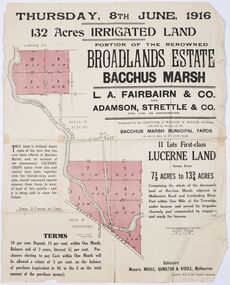 Bacchus Marsh & District Historical Society
Map - Land Sales Plan, Broadlands Estate, Bacchus Marsh, 1916
This land sales map was produced by real estate agents for an auction of part of a property near Bacchus Marsh known as the Broadlands Estate. 132 acres of irrigated land in 11 separate lots was to be auctioned on the 8th of June 1916. On the 27 May 1916, nine of the 11 eleven lots were withdrawn from sale. The reason stated was due to "road and severance difficulties", according to a notice in the Bacchus Marsh Express newspaper on 27 May, 1916, page.2. When the sale took place on 8th June the two lots were passed in but the local newspaper reported they were expected to be sold privately, see Express, 17 June, 1916, page. 2. The Broadlands Estate was owned by the Miller family whose father Henry Miller, 1809-1888, was a politician and an immensely wealthy financier in Victoria.A typical example of a land sale map of this era. The Broadlands Estate was just over 2,000 acres at its its peak size and was a significant holding of land in the Bacchus Marsh district. Paper printed land sales mapbroadlands estate bacchus marsh, land sales bacchus marsh, farms bacchus marsh, henry miller 1809-1888 -
Bendigo Historical Society Inc.
Map - RAVENSWOOD, COUNTIES OF BENDIGO & TALBOT, 12-12-22
Map, Ravenswood, Counties of Bendigo & Talbot, Shelbourne, Walmer, Harcourt, Sutton Grange, Mandurang, Lockwood.By Authority A.J.Mullett, Govt. Printer, Melbourne. Photo-Lithographed at the Dept. of Lands and Survey, Melbourne by W.J.Butson 12-12-22, Price1/-. (number 87 in map cupboard 1)A.J.Mullett. Govt. Printer, Melbourne.map, bendigo, ravenswood -
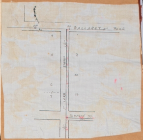 Bacchus Marsh & District Historical Society
Map, Lord Street, Bacchus Marsh. Undated
A small single page map showing the line of Lord Street Bacchus Marsh between Ballarat Road (Main Street) and Simpson Street. Part of a set of maps which are pasted into a bound volume containing 76 maps or plans in total. High resolution digital image stored on BMDHS computer network. bacchus marsh victoria maps, lord street bacchus marsh maps -
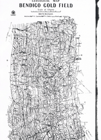 Bendigo Historical Society Inc.
Map - LONG GULLY HISTORY GROUP COLLECTION: GEOLOGICAL MAP - BENDIGO GOLD FIELD
Copy of a Geological Map of the Bendigo Gold Field. Map shows Lines of Reef, Anticlines, Synclines, Shafts, Alluvial Contours Gullies and some street names. Copy is hard to read. There are two pages.bendigo, history, long gully history group, the long gully history group - geological map - bendigo gold field, mines department, h herman, lightning hill line, hustlers line, derby line, paddy's gully line, garden gully line, deborah line, sheepshead line, new chum line, nell gwynne line, british and foreign line, napoleon line, carshalton line, thistle line, christmas line, lancashire line -
Bendigo Historical Society Inc.
Map - YARRAYNE : COUNTY OF BENDIGO, 6-1-32
Map. Yarrayne, County of Bendigo, Janiember East; Pompapiel, Salisbury, Bridgewater, Salisbury West, Powlett. Photo-Lithographed at the Department of Lands and Survey, Melbourne. Price 2/-. 6-1-32. (number 12 in map cupboard 1)H.J. Green, Government Printermap, bendigo, yarrayne -
Bendigo Historical Society Inc.
Map - PLAN NEW CHUM LINE OF REEF
Plan showing outcrops of reefs on supposed extension south of the New Chum line of reef from the Eureka extended company's ground. Scale 8 chains to 1 inchplan, bendigo, new chum line of reef -
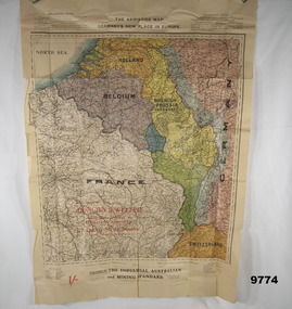 Bendigo Military Museum
Map - ARMISTICE MAP, WW1, The Industrial Australian and Mining Standard, Melbourne and Sydney>, Post June 1919
The different colours cover France, Belgium, Luxembourg, Alsace, Lorraine, The Rhine, Nuetral zone, Germany, Switzerland, Holland, Rhenish Prussia (Germany) Item in the collection relating to C.J.C. McQuie MM, refer Cat No 9680P for his service details.Map in colour showing a large section of Europe, the boundaries set up after the Armistice in 1919, countries are in different colours.At the top, "The Armistice map, Germany's new place in Europe"maps, europe, armistice, mcquie -
Stawell Historical Society Inc
Map, Underground Survey of the Principal Mines of Stawell 1879, 1879
Pleasant Creek & Newington, Prince Patrick, Prince Alfred, Pioneer and Galatea, Pleasant Creek Cross Reef No. 1&2, Magdala, Old Shaft, Extended Cross Reef, Crown Cross, Great Northern, Sloanes & Scotchmans, South Cross, 10 & 11 United Scotchmans South Cross, Scotchmans Shafts, North Scothmans, West Scotchmans, Emerald Isle & Rose of Denmark, Albion, South Scotchmans, Newington & Pleasant Creek, Pleasant Creek Cross Reef, Moonlight, Extended Cross Reef, Crown cross United, Great Northern ShaftVery large Map on cloth backing, showing cross sections of mines.Surveyed by H.C. Bates. Drawn by Arthur Edwards. October 30th 1879. Scales 120 feet to an inchmining, gold -
 Bendigo Historical Society Inc.
Map - MAP: BENDIGO SHEET 2, 1910, 1910
Map. Map with timber ends, showing names of property owners. Bendigo from Olinda Street west to Prouses Road and Bennet / Wattle Street to Dooley Street in the north. Copy of map taken for research purposes. Map prepared by Department of Lands and Survey, Melbourne by T.F. McGauran 4.1.10 (1910)map, bendigo, residence areas, 1910 -
Bendigo Historical Society Inc.
Map - RAVENSWOOD : COUNTY OF BENDIGO, 1971
Map. Ravenswood, County of Bendigo, Township of Ravenswood, County of Talbot, Bradford; Walmer; Harcourt; Lockwood; Mandurang; Sutton Grange.By Authority C.H.Rixon, Government Printer, Melbourne.Drawn and Reproduced at the Dept. of Crown Lands and Survey, Victoria. 1971. Price $1.00 (number 5 in map cupboard 1)C.H.Rixon, Government Printermap, bendigo, ravenswood -
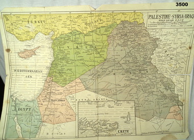 Bendigo Military Museum
Map - MAP MIDDLE EAST, Dyag Press Ltd
Coloured map of Palestine, Syria, Iraq & Crete, countries involved in the war.documents - maps, military history, middle east -
Whitehorse Historical Society Inc.
Map, Site for Wesleyan Church, Nunawading, 1855
Photocopy of manuscript map showing names of landholders.Photocopy of manuscript map showing names of landholders. Note on verso: Plan of allotments in the City of Melbourne appropriated to the Wesleyans. Site for Wesleyan Church, Nunawading 1848 (Corner of Burwood and Elgar Roads - S of Burwood, W of Elgar)Photocopy of manuscript map showing names of landholders. churches, wesleyan church, burwood, burwood road, burwood, elgar road, burwood, maps -
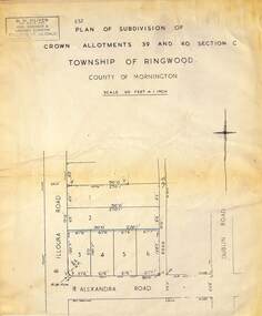 Ringwood and District Historical Society
Map - Plan of Subdivision, Part of Crown Allotments 39 and 40 Section C, Township of Ringwood, County of Mornington - (Undated - circa 1930s)
Copy of land title map on light cardboard backing showing layout and size of 6 allotments in Illoura Road (later Illoura Avenue) and Alexandra Road, Ringwood East, Victoria. Rubber stamp imprint in top left corner - D.H. Oliver, Civil Engineer & Licensed Surveyor, Bellevue Street Lilydale, Phone Lilydale 91.