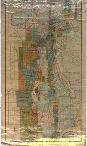
Showing 2323 items in the category Documentation with item type Map
-
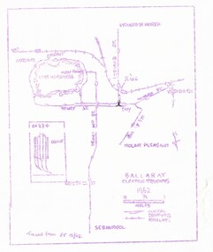 Ballarat Tramway Museum
Map, Ballarat and Bendigo tram systems, 1962 and 1965
Set of two spirit duplicated maps of the Ballarat and Bendigo tram systems, showing the track layout for both cities. .1 - Ballarat - dated 1962, noted as being traced from Electric Traction 12/62. .2 - Bendigo - dated 1965, noted as being tracked from ET 6/65. Most likely used for tour notes or other similar productions.trams, tramways, map, ballarat, bendigo -
 Bendigo Historical Society Inc.
Map - MARKS COLLECTION: CLAIM MAP SANDHURST
Original hand drawn map showing lease holders along Mt. Korong Road, Sandhurst area. Names include Gold Mines Co., Hercules Co., H. Koch, Prince Alfred Co, Advance Co., J. Steane, Skeals, Abel & Co., Mounts(?) Bay co., Wellington Co., Waterloo Co., Endeavour Co., W.H. Langdon, Bridgman & Co. Written in blue pencil on top RH corner in script Syme Well, Nova Ste (indecipherable), German Aleno Co., Concord, Rae. Written on back of map in black pen 'Maps'.map, bendigo, mining leases -
 Federation University Historical Collection
Map, Ballarat Goldfield, c1898
This map shows geological features, suggests the last basalt flow, and includes alotments and names of Mining Companies. Although this map has no date on it the Ballarat Industrial School is used for dating purposed. The Ballarat Industrial School ran from 1869-1879, but the term Ballarat Industrial School Reserve was still in use in 1898 and possibly beyond.Geological Map of Ballarat with 3 holes in the left hand side. The map indicates the position of Lake Wendouree, Township of Warrenheip, Ballarat East, Industrial School Reserve, Winters Swamp, Police Paddock, Wyndholm Premptive Right (Salton and Waldie), Black Hill, Vale Park Reserve, Pennyweight Hill, Little Bendigo, Black Swamp Lead, monte Christo Reef, Chinaman's Gully, Miners Rest, Pincotts Dam, Northumberland Gully. It also show the following goldmining companies: City of Ballarat, Kohinor, Hand and Band, Great North West, Northern Junction, Kneeshaw, Rossers Freehold, Silurial.ballarat, warrenheip, lake wendouree, ballarat east, winters swamp, winter swamp, wyndholm premptive right, cemetery, vale park reserve, little bendigo, kneeshaw co., industrial school reserve, kirks dam, pincotts dam, black hill, wombat hill, dead horse gully, miners rest, mt rowan, salton and waldie, rose hill co, great north west no 1, rose's freehold co, hand and band co, police reserve, police paddock, mount rowan, ballarat industrial school reserve, market reserve, winter's swamp, kneeshar co, monte cristo line of reef, chinaman's gully or black snake, milkmaid's gully, ballarat gold field, bakery hil lead, old gravel pits lead, golden point lead, eureka lead, miner's rest, yarrowee creek, leigh creek, black swamp lead, yorkshire reef, nil desperandum reef, cockatoo lead, hit or miss gully, herbert werner frederick de nully, pennyweight hill, esmond's lead, ash's lead, nightingale lead, john bull gully, gladstone reef, whitehorse reef, petticoat creek, pincott's dam, frenchman's gully, tim's crushing plant, jenkin's gully, california gully, drake's creek, sulton and waldie, ballarat undustrial school, ballarat & mariborough railway -
 Ballan Shire Historical Society
Map - Map. Korweinguboora, Department of Lands and Survey, Korweinguboora. Counties of Talbot and Grant
A map of the Korweinguboora area showing roads, forests, railway lines and properties with the owners names.The inclusion of the names of landowners is of significance and value to historians.A map of the Korweinguboora area showing land subdivisions and names of owners and other physical features. There is a scale in chains. No date is certain but it could be 1902. The map has been repaired with sellotape.There are various pencil annotations but the are difficult to read.talbot, moorarbool west, wombat, bullarto, korweinguboora, moorarbool east, dean, wombat state forest, barkstead -
 Bendigo Historical Society Inc.
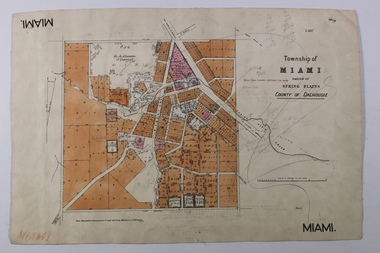
Map - MIAMI ( MIA MIA), 26/06/1906
The name Miami on the is a misprint Map: Township of Miami (Mia Mia), Parish of Spring Plains, County of Dalhousiemap, dalhousie, township, mia mia, spring plains creek -
 Glenelg Shire Council Cultural Collection
Map - Fold-out fire control map - Region 4 Victoria, n.d
Fold-out fire control map for Region 4 - Victoria Northern sheet, includes numerical and alphabetical index. -
 Ringwood and District Historical Society
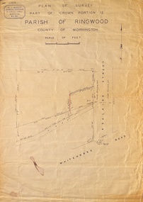
Map, Plan of Survey, Part of CP12, Adelaide Street, Ringwood, Circa 1920s
Undated map of part of commercial area in Parish of Ringwood, County of Mornington showing Adelaide Street, Whitehorse Road, and un-named laneway behind Whitehorse Road shops marked as Road, and New Road Alignment. Made by H.J. Macey, Licensed Surveyor 36 Narissa Street Burwood BX1917. -
Clunes Museum
Map - MAP OF CLUNES, CHARLES FENTON
THESE MAPS WERE SOLD IN CLUNES MUSEUM PRIOR TO TH REDEVELOPMENTOF THE WAREHOUSE BY HEPBURN SHIRE COUNCIL. MAPS WERE SOLD FOR $ 1.504 COPIES OF MAP OF CLUNES 1987map, clunes 1987, charles fenton, map of clunes -
 Whitehorse Historical Society Inc.
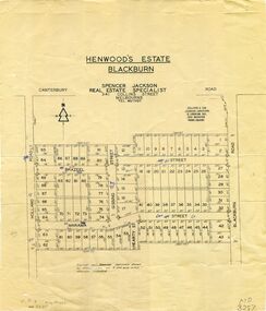
Map, Henwoods Estate, Blackburn
Plan of subdivision in Blackburn SouthPlan of subdivision in Blackburn South between Holland Road and Blackburn Road. Estate advertised by Spencer Jackson, 341 Collins Street.Plan of subdivision in Blackburn South land subdivision, henwoods estate, blackburn south, holland road, brazeel street, marama street, blackburn road, gissing street, hearty street -
Bendigo Historical Society Inc.
Map - CAMPBELL COLLECTION: BENDIGO AND DISTRICT MAPS, 9-4-29
Map. Campaspe, Parish of Kimbolton, Scale 20 chains to 1 inch. Total area 4117 acres, Campaspe River, Prepared in W.P.B. by W.J.Galbraith from Parish and Assessment Plans. (number 384 in map cupboard 1)W.J.Galbraithmap, bendigo, agricultural lands -
Bendigo Historical Society Inc.
Map - SANDHURST SHEET 4, January 1947
Map: Sandhurst sheet 4. Parish plan ( number 198 in Map Cupboard 1)map, bendigo, city streets, sandhurst -
 Bendigo Historical Society Inc.
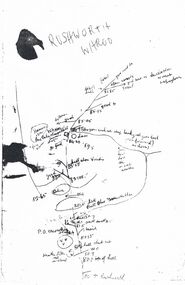
Map - PETER ELLIS COLLECTION: MAP
Five photocopies of drawings of the Rushworth area and three copies of Rushworth-Whroo. All maps have various features and some plants noted. Also mentioned is the Balaclava Hill Open Cut Mine.map, victoria, rushworth/whroo, peter ellis collection, rushworth, whroo, aboriginal water holes, balaclava hill open cut mine -
Stawell Historical Society Inc
Map, Special Surveys, District of Ararat, 1968
Special Surveys, District of Araratstawell -
Bendigo Historical Society Inc.
Map - RAVENSWOOD, COUNTIES OF BENDIGO & TALBOT, 12-12-22
Map, Ravenswood, Counties of Bendigo & Talbot, Shelbourne, Walmer, Harcourt, Sutton Grange, Mandurang, Lockwood.By Authority A.J.Mullett, Govt. Printer, Melbourne. Photo-Lithographed at the Dept. of Lands and Survey, Melbourne by W.J.Butson 12-12-22, Price1/-. (number 87 in map cupboard 1)A.J.Mullett. Govt. Printer, Melbourne.map, bendigo, ravenswood -
Bendigo Historical Society Inc.
Map - PLAN SHEEPWASH CREEK
Two laminated maps, one in colour the other black and white, showing German Gully, sheepwash creek, milkmaid flat. -
 Ringwood and District Historical Society
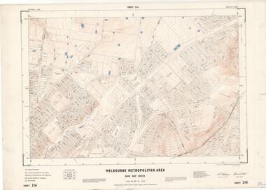
Map - Melbourne Metropolitan Area Base Map Series, Sheet 216 - Ringwood area, 1967
Map prepared by Dept of Lands and Survey and MMBW from State Aerial Survey June 1957 and Cadastral Survey information July 1967. This sheet comprises parts of Municipalities of Croydon, Doncaster & Templestowe, and Ringwood, and Parishes of Ringwood and Warrandyte.Scale: 400 feet to 1 inch. Contours at 5 feet vertical interval. By Authority: A.C. Brooks, Commonwealth Printer, Melbourne. -
Bendigo Historical Society Inc.
Map - GOORNONG, 1/10/1906
Map: Township of Goornong, Parish of Goornong, County of Bendigo ( number 154 in Map Cupboard 1)map, bendigo, township, goornong, county of bendigo -
 Bacchus Marsh & District Historical Society
Map, Balliang Parish Map, County of Grant c.1907
A single page paper map showing parish plan map for Balliang. This parish area contains the localities of Balliang and Balliang East and is located south of the township of Bacchus Marsh. The map is pasted into a bound volume containing 76 maps or plans in total. High resolution digital image stored on BMDHS computer network. balliang victoria maps, balliang parish maps -
 Vision Australia
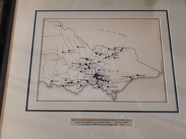
Map - Object, Victorian railways map
A black and white map of Victoria showing the railway lines where mail is transported and the individual towns listed next to the dot that provides location of such. Underneath is written "Map of Victoria showing the localities beyond the suburbs of Melbourne to which library books are sent to blind members. Books are carried over the railways FREE there is no charge to the readers." Through the work of Tilly Aston, braille postage was provided free by the Victorian Railways which greatly assisted the Braille Library in reaching members who resided outside of Melbourne. This map was produced to show the extent of the work by the Victorian Association of Braille Writers and the need for reading materials across the state.Paper of Victorian railway lines mounted in framevictorian association of braille writers, marketing -
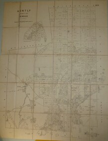 Bendigo Historical Society Inc.
Map - JACK FLYNN COLLECTION: HUNTLY, 8/09/1921
Map: Parish of Huntly, County of Bendigo. Parish plan.By Authority, Govt., Printer. A. J. Mullett. Photo Lithographed at the Department of Land and Survey Melbourne By W. J. Butsonmap, bendigo, parish plan, huntly -
Stawell Historical Society Inc
Map, Water Supply, Wimmera Mallee Water
Water Supply, Wimmera Mallee Waterstawell, water -
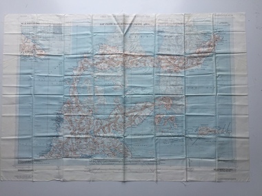 B-24 Liberator Memorial Restoration Australia Inc
Map - US World War II multi-coloured map- Southwest Pacific Area, No. 23 North Celebes, No. 24 South Celebes, 1942-1943
Silk and rayon maps were produced by the United States (c. 7.5 million in total), Great Britain (some 1.75 million in total) and Australia during World War II. They were issued to Allied military personnel as part of 'escape and evasion' kits.This map, printed on acetate rayon, is an original US 'escape and evasion' kit map from World War II.A multi-coloured, contoured, double-sided map printed on acetate rayon AAF Cloth Map - Southwest Pacific Area Side 1 - No. 23 North Celebes Side 2 - No. 24 South Celebesworld war ii, silk maps, united states of america, a189 -
 Bacchus Marsh & District Historical Society
Map, Trentham Parish Map 1905 Copy 1
A single page paper map showing the map for the Parish of Trentham in the Counties of Dalhousie and Bourke. A cadastral map showing parish boundaries and land ownership. The map is pasted into a bound volume containing 76 maps or plans in total. High resolution digital image stored on BMDHS computer network. Photo-lithographed at the Department of Lands and Survey, Melbourne by T.F. McGauran 22.3.05 trentham parish maps, trentham parish plan, bacchus marsh region parish plans -
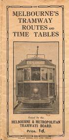 Melbourne Tram Museum
Map, Melbourne & Metropolitan Tramways Board (MMTB), Melbourne's tramway routes and timetables - MMTB, 1925
Map of the MMTB Tramway routes 1925 with a list of first and last cars, along with photographs of Wattle Park, Luna Park, and Studley Park. Provides information for the Prahran and Malvern lines, Hawthorn, Footscray, Essendon, Coburg, Kew, St Kilda, cable tram routes, and buses. Also provides information for passengers. The cover photo is of the front of W 296, with the destination of Esplanade. The map is dated by the opening of the line to West Brunswick as far as Albion St, the City Road to St Kilda line via Sturt St lines, and the electric line in Flemington Road which were all opened during mid to late 1925. See Reference. Shows a number of buildings and locations by a numbered reference list, including the Federal Parliament house. The map has advertisements around the outside of the map for Kiwi Shoe or boot polish.Yields information about the Melbourne tramway system in 1925 and demonstrates the methodology the MMTB used to provide information to travellers. Shows both cable and electric tram lines and the development of the Melbourne system.Map book - 15 fold paper titled "Melbourne's tramway routes and timetables"trams, tramways, mmtb, tramway maps, wattle park, studley park, timetables, cable trams, w class tram, tram 296, kiwi shoe polish -
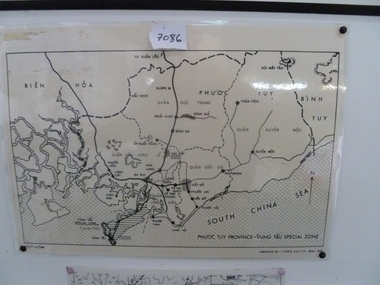 National Vietnam Veterans Museum (NVVM)
Map, Map of Phuoc Tuy Province - Vung Tau Special Zone, 1/05/1968 12:00:00 AM
Laminated map of Phuoc Tuy Province - Vung Tau special zone. Oulne of hamlets and military bases.AFV/F7-12/1188map, vung tau, 1 atf, 1 alsg -
 Federation University Historical Collection
Map, Ballarat and Sebastapol Gold Mines, Late 19th Century
colored printed map on paper lined onto linen backingprinted "Rider & Mercer's Plan of the Ballarat & Sebastapol Gold Mines Scale 30 Chains to One Inch"gold mines, mine allotment map, mining leases, ballarat, sebastopol, rider and mercer, golden shaft co, prince of wales and bonshaw united, leviathan gold mines, holst and co, speedwell co, sebastopol plateau, rothschild co, tower hill co, south plateau, south star co, band of hop and albion consols, prince regent co, chenhall and co, despza, buninyong estate, one eye hully, winter's freehold, luplau plateau, e. morey, carrill's quartz -
Bendigo Historical Society Inc.
Map - TOWNSHIP OF SANDHURST MAP
Map township of Sandhurst Portion B Bendigo Creek. Victoria zincographed at the Crown land's office, nos 54/21-57/12 Melbourne, April 21st 1857 (by G. Collis). -
Bendigo Historical Society Inc.
Map - EPPALOCK, 3/07/1890
Map: Parish of Eppalock. County of Bendigo. Parish plan (number 338 in map cupboard 1)map, bendigo, parish plan, eppalock -
Whitehorse Historical Society Inc.
Map, Mason's Paddock, Blackburn, 1919
Mason's Paddock, Blackburn, plan of subdivision, 17 lots, realising auction, Saturday Nov 29, 1919.Mason's Paddock, Blackburn, plan of subdivision, 17 lots, realising auction, Saturday Nov 29, 1919. Agents T.R.B. Morton & Son.Mason's Paddock, Blackburn, plan of subdivision, 17 lots, realising auction, Saturday Nov 29, 1919. t.r.b. morton & son, blackburn, masons paddock, blackburn road, blackburn, masons road, blackburn, canterbury road, blackburn -
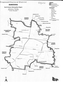 Greensborough Historical Society
Map - Map (Copy), Electoral Boundaries Commission, Proposed electoral district: Bundoora, 01/07/2021
Proposed revised electoral boundaries for the electoral district of Bundoora (North-Eastern Metropolitan Region) as at 01/07/20211p. black and white copy of mapelectoral boundaries, bundoora - maps, victoria - parliament