Showing 2323 items in the category Documentation with item type Map
-
 Bendigo Historical Society Inc.
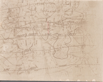
Map - GOLDFIELD MAP
Portion of the map of the Bendigo Goldfield with the Paddy's Gully Line of Reef near the centre. Streets, contours and gullies are included. Underlined in red is the North Johnson Shaft.map, bendigo, goldfields, goldfield map, paddy's gully line of reef, north johnson shaft, mine shafts -
 Bacchus Marsh & District Historical Society
Map, Myrniong Parish Map, County of Bourke, 1882
A single page paper map showing the map for the Parish of Myrniong in the County of Bourke. A cadastral map showing parish boundaries and land ownership. The map is pasted into a bound volume containing 76 maps or plans in total. High resolution digital image stored on BMDHS computer network. Photo-lithographed at the Department of Lands and Survey, Melbourne by J. Noone, 17.7.82myrniong parish plan, myrniong parish maps, bacchus marsh region parish plans -
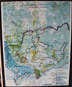
 Glenelg Shire Council Cultural Collection
Map - Fold-out fire control map - Region 4 Victoria, n.d
Fold-out fire control map for Region 4 - Victoria Northern sheet, includes numerical and alphabetical index. -
Glenelg Shire Council Cultural Collection
Map - Map - Portland, Victoria, n.d
Map of Portland, produced as an advertising medium by Portland Chicken Inn. Green card, dark blue print. Image of Portland Harbour on front, street index on back, open to Portland map, Chicken Inn marked on map. -
Clunes Museum
Map - MAPS
A MAP OF CLUNES TOWNSHIP. ORIGINAL AND COPY. ALL STREETS WITH ALLOTMENT NUMBERS CRESWICK CREEK - KILKENNY CREEK - BALLARAT TO MARYBOROUGH RAILWAY LINE.CLUNESlocal history, document, maps, clunes township -
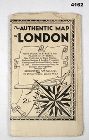 Bendigo Military Museum
Map - MAP of LONDON, The Authentic Map of London
Map of London with also places of interest. Part of th collection of Frederick Gardner Davey DFC No 410533 RAAF. Refer cCat No 3536P for his service details.Black and white folded street map with transport routes/stations marked in orange. Cover is black and white print, features a scroll and compass design inside a B & W border, written details in black type, street index printed on inside of the cover.map, london -
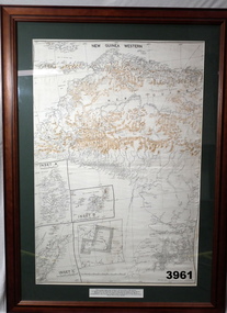 Bendigo Military Museum
Map - MAP, NEW GUINEA FRAMED, 1941 onwards
Map of Western section of New Guinea. Black print on white background with mountain ridges in tan. Mounted with green border & brown wooden frame, glass front & white cardboard backing with wire hanging strap on back. Inset LHS bottom: A: Aroe Island B: KIA Island C: Taniimba IslandPrinted in black at top centre: “NEW GUINEA WESTERN’ Printed on border under map: “These escape maps were carried in the zip pockets of life jackets by fighter pilots in WW2. This map was presented to A.S.R. on the 12/7/79 by Councillor Ian McKenzie, Mayor of Eaglehawk, who served as a fighter pilot in 78th SQN in S.W. Pacific area during 1943-44.”map, new guinea, western, raaf -
Stawell Historical Society Inc
Map, Stawell Gold Mine, SGM Mineralized System Longitudinal Projection showing Diamond Drilling Holes 2007, June 2007
Section of Big Hill showing Diamond Drill holes through Magdala, Magdala North and Golden Gift Ore bodies to 2000m levelLegend of Mine workings numbered. 1980's mining, gold, map -
Bendigo Historical Society Inc.
Map - KIMBOLTON : COUNTY OF BENDIGO, 1966
Map. Kimbolton, County of Bendigo. Eppalock, Lyell, Knowsley, Langwornor, Redesdale, County of Dalhouse, County of Rodney, Campaspe River, Coliban River,By authority A.C.Brooks, Government Printer, Melbourne. Drawn and reproduced at the Department of Lands and Survey, Melbourne, 1966, Price $1.00 (number 65 in map cupboard 1)A.C. Brooks, Government Printer, Melbourne.map, bendigo, kimbolton -
Whitehorse Historical Society Inc.
Map - WW1 Trench map, Belgium collected by C H Honybun, Belgium WW1 map, Aug 1917
WW1 map of Belgium Edition 1. Sheet 28 S.W. and S.E. with trenches in red around the towns of Comines and Warnetonnon-fictionWW1 map of Belgium Edition 1. Sheet 28 S.W. and S.E. with trenches in red around the towns of Comines and Warnetonworld war 1914 - 1918, maps -
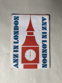 Robin Boyd Foundation
Map, ANZ in London; A map for visitors to London
walsh st library -
Bendigo Historical Society Inc.
Map - SANDHURST GOLDFIELDS MAP, 1873
BHS CollectionTopographical map of the Sandhurst Goldfilelds. Surveyed by R Brough. May 1873 Coloured map.bendigo, gold mining, sandhurst goldfields -
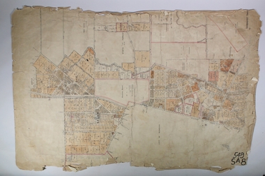 Bendigo Historical Society Inc.
Map - SANDHURST (PART), Circa 1900
Map: Sandhurst ( part), sheet No., Missingmap, bendigo, parish plan, sandhurst -
Stawell Historical Society Inc
Map - Plan, Glenorchy Cemetery, c 1960
Printed map of plots on backing cardScale 1 inch to 12 feetburials -
 Ringwood RSL Sub-Branch
Map - Vietnam map, 1969-1972 map Vietnam on hard backing
-
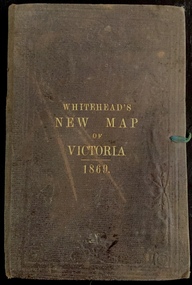 Kew Historical Society Inc
Map, Whitehead's Map of Victoria, With Alphabetical Key, 1869, 1869
When E. Whitehead's New Map of Victoria was released in 1869, an advertisement in the Bendigo Advertiser (16 July 1869) noted that: "This beautifully engraved Map has been revised and brought down to the present time; and, with the Alphabetical Key, is the most complete and the cheapest Map ever published; Price, 6d plain; 1s colored; 2s 6d in case; on linen, post free, 2d extra. E.. WHITEHEAD and CO, Publishers, 67 Collins-street east." The following year, 1870, Whitehead's promoted the edition in the Portland Guardian and Normanby General Advertiser (3 January 1870), advising that: "WHITEHEAD'S NEW MAP OF VICTORIA, 1869 ... is corrected to the latest date, and around is arranged an Alphabetical Key, with Post Towns and Money Order Olffices marked. The Map being divided into squares and numbered, by reference to the Key any place can be found immediately. Price Is beautifully colored, or mounted on linen in case, 2s 6d. Post free, 2d extra, in Victoria. B. Whitehead and C0., Puolishers, 67 Collins-street East, Melbourne". In the same edition of the Portland Advertiser, they also promoted their business generally, saying: "E WHITEHEAD and Co., Stationers, Engravers, Lithographers, 67 Collins street East, execute every description of Lithographic PRINTING, BILL-HEADS. NOTE Headings. Business Dies Engraved and Embossed on Envelopes &c. ARMS, MONOGRAMS, AND CRESTS Engraved and Embossed in Colour, superior to any other house in the Colony. Specimens, post free, 2d. Lithographers, &c, to H.R.H. the Duke of Edinburgh, and Die-inkers and Embossers to His Excellency Sir J. H. T. Manners-Sutton, K C.B. Orders executed for the Trade". Whitehead’s New Map of Victoria 1869 is is an important record of region created towards the end of the Victorian Gold Rush (1851-1869). In addition to its historical significance, this is a rare map, of which the only known copies in Australian public collections are those held at the National Library of Australia, the State Library of Victoria, State Library of New South Wales and the University of Queensland Library.Map of Victoria with gold mining areas, notes on topography, transport routes. Relief shown by hachures. List of towns with distance from Melbourne in map margin. [Melbourne] : Printed & Published by ... E Whitehead & Co ... 67 Collins Street East, 1869 1 map : col., mounted on linen ; 38.4 x 55.4 cm, folded to 18 x 12 cm.Cover "WHITEHEAD'S NEW MAP OF VICTORIA 1869"maps - victoria - 1860s, e whitehead's new map of victoria 1869, whitehead's map of victoria with alphabetical key 1869, cartography, gold rush -
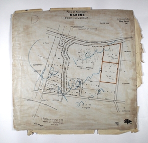 Bendigo Historical Society Inc.
Map - MARONG ALLOTMENTS, 25/08/1906
Map: Plan of Allotments at Marong, Parish of Marong, County of Bendigo. Hand draughted mapmap, bendigo, parish plan, marong, parish of marong -
Merbein District Historical Society
Map, Mildura and District Map, After 1954
merbein, yelta, merbein south, the lake, merbein west, birdwoodton -
Bendigo Historical Society Inc.
Map - CITY OF BENDIGO (PART), Circaa 1900
Map: parish plan showing an area North West oh Napier St., Weeroona Ave. intersection ( number 216 in Map Cupboard 1)map, bendigo, parish plan, bendigo, napier st, weeroona avenue -
Whitehorse Historical Society Inc.
Map, A Plan of part of the Parish of Nunawading, 1984
Hand drawn plan showing the owners or occupiers of land c1860'.Hand drawn plan showing the owners or occupiers of land c1860'. Includes proposed townships of New Brunswick and Norwich. Scate 1 inch : 10 chains.Hand drawn plan showing the owners or occupiers of land c1860'. maps, shire of nunawading -
Bendigo Historical Society Inc.
Map - MAP: VIRGINIA MINE GARDEN GULLY LINE OF REEF
Map of Virginia Mine on the Garden Gully line of reef, Eaglehawk, transverse section. Shaft, levels and Garden Gully anticlinal axial line drawn. Key shows types of formations - quartz, spurs, sandstone, slate, cleavage, lava. This map forms part of the Geological Survey of Victoria, Structure of Bendigo Goldfield report, No. 47, 1923. H.Herman, late Director of Geological Survey.Geological Survey Victoria, Geological Survey Office, Bendigo.bendigo, gold mining, virgina mine eaglehawk, eaglehawk, bendigo, gold mining, virginia mine, garden gully line of reef. -
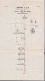 Bendigo Historical Society Inc.
Map - STRUGNELL COLLECTION: HUSTLER'S LINE OF REEFS, BENDIGO, September 1913
Map, Hustler's Line of Reef, Hustler's Royal Reserve No. 2, Park Shaft, Bendigo, Plate No. 1X (9). Bulletin No 33 Signed H.A.Whitelaw Underground survey Office Bendigo September 1913 Drawing shows mine shaft to over 1099 feet deep and appears to show samples of connecting horizontal shafts with their respective mineral contentsUnderground Survey Office, Bendigo.map, bendigo, hustler's royal reserve no. 2 mine* -
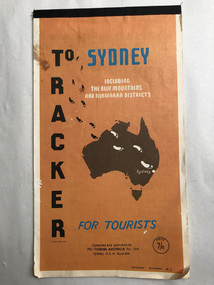 Robin Boyd Foundation
Map, Pic-touring Australia, Tracker to Sydney
Includes the blue mountains and Illawarra districts. beautiful simplified coloured maps. Price 7/6, so pre-decimalisationwalsh st library -
Moorabbin Air Museum
Map (Item) - RACV Royal Automobile Club Melbourne Victoria and Suburbs map
-
Bendigo Historical Society Inc.
Map - WHIRRAKEE, No date visible
Map: Whirrakee, County of Bendigo. Parish plan (number 258 in map cupboard 1)map, bendigo, parish plan, whirrakee -
Port Melbourne Historical & Preservation Society
Map, G S Williams, City Engineer, City of Port Melbourne, Dec 1963
Map of City of Port Melbourne (brick areas marked in colour), 1963.G. S. Williams (City Engineer)town planning, g s williams, troedel and cooper -
 Federation University Historical Collection
Map, Central Ballarat Retail and Business Guide, 2004, 11/2004
Map of the Ballarat Central area, and business guide.ballarat central, brown hill, ballarat east -
 Bendigo Historical Society Inc.
Map - SANDHURST SHEET 2, 14/03/1923 ?
Map: Sandhurst sheet 2. Parish planmap, bendigo, parish plan, sandhurst -
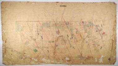 Bendigo Historical Society Inc.
Map - MARONG, Circa 1871
Map; Marong, Hand Draughted parish planmap, bendigo, parish plan, marong -
Stawell Historical Society Inc
Map, R.O. Robson - Authorised Surveyor, Road from Glenorchy to near Geary's Selection Callawaddy 1880, 29.04.1880
Survey for Road CreationCloth Backed Map. Plan of Road.Parishes of Richella & Callawadda. County of Borong. Plan of Road. R.O. Robson Authorised Surveyor Stawell 29.04.80