Showing 2323 items in the category Documentation with item type Map
-
 Whitehorse Historical Society Inc.
Map, Boronia Road, Vermont, 1970
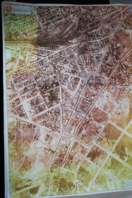
Enlargement of aerial photograph of Boronia Road, Vermont. State Aerial Survey 1970 Run 37Enlargement of aerial photograph of Boronia Road, Vermont. State Aerial Survey 1970 Run 37Enlargement of aerial photograph of Boronia Road, Vermont. State Aerial Survey 1970 Run 37boronia road, vermont, lusk drive, vermont, morack road, vermont south, allison court, vermont, trinian street, vermont, cosgrove street, vermont, mawson court, vermont, aerial photographs -
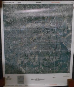
 Bendigo Historical Society Inc.
Map - BENDIGO MAP AERIAL VIEW, 1934
Map of Bendigo. Aerial View of Bendigo taken in 1934. Published by City of Great Bendigo.photograph, aerial, bendigo 1934 -
Bendigo Historical Society Inc.
Map - MANDURANG 1, March 1947
Map: Mandurang 1, County of Bendigo. Parish plan (number 295 in map cupboard 1)map, bendigo, parish plan, mandurang -
Whitehorse Historical Society Inc.
Map, Mitcham Riding, n.d
Shire of Nunawading: Mitcham Riding [n.d.] between Mitcham and Heatherdale Roads) (Shows electric light mains, MMBW reserves and railway line.mitcham, maps, vermont -
 Kew Historical Society Inc
Map, Department of Lands & Survey, Map of Melbourne & Suburbs, 1899
The Melbourne & Metropolitan Board of Works was established in 1891 to oversee the introduction of a sewerage and water reticulation system in Melbourne and its suburbs. This complementary map was produced by the Department of Crown Lands & Survey [Victoria] in the same decade showing the distribution of water in Melbourne for use by fire brigades. While by 1910, there were 123,227 connections to Melbourne's water supply system, it is unclear in this 1899 map whether water was supplied to all built structures in the defined areas or only to fire hydrants and stand pipes, as we know that the first connection of a building to the sewerage system in Kew only occurred in 1904.Map accompanying report on fire protection of Melbourne showing those areas supplied with water in colour.water reticulation -- melbourne (vic.), department of lands & survey -- historic maps, fire brigades -- melbourne (vic.), cartography -
 Bendigo Military Museum
Map - MAPS, VIETNAM, April 1969
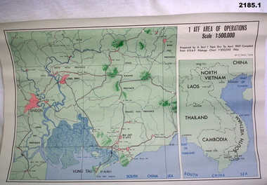
1.) Paper map, colour with black print, scale 1:500,000 area covers Saigon, Long Bin, Nui Dat, Vung Tau. .2) Laminated paper map showing city of Vung Tau with details of tourist destinations, hotels, churches, black & red print, scale 1:12,500 approx.documents - maps - military & tourist, vietnam -
 Marysville & District Historical Society
Map (Item) - Tourist Map, Tourists Resorts' Committee, Tourist's Map of Healesville Marysville and Warburton Districts, 13.10.1925
A tourist map for Healesville, Marysville and Warburton that was produced by the Tourists Resorts' Committee. This map was produced in 1925.A tourist map for Healesville, Marysville and Warburton that was produced by the Tourists Resorts' Committee.Photo Lithographed at the Department of Lands and Survey, Melbourne by W.J. Butson./ 13.10.25healesville, marysville, warburton, victoria, tourists resorts' committee, ben cairn, mount donna buang, the black's spur, the acheron valley, narbethong, launching place, tourist information, tourism, map, tourist map -
 Bendigo Historical Society Inc.
Map - FRED COWIE COLLECTION: AERIAL MAPS OF HEATHCOTE/EPPALOCK, 28-9-60
Map, Heathcote C3, Aerial Survey of Victoria, Photo-map prepared by Department of Crown Lands and Survey from photographs taken in 1960.Copied photographically at the Central Plan Office. Date 28-9 60, C.P.O.Neg. No.21588.Campaspe River, Coliban River. Flower Hill. Fred Cowie,46 McIvor Rd.Bendigo (Not located 29.9.2022)Central Plan Office.map, heathcote, fred cowie -
Port Melbourne Historical & Preservation Society
Map, Fredrick C COOK C.E.L.S, City of Port Melbourne, Nov 1938
1/600 map of the City of Port Melbourne by City Engineer, Fredrick C COOK.Map of Port Melbourne, November 1938local government - city of port melbourne, fredrick c cook -
Bendigo Historical Society Inc.
Map - HAWKESTONE : COUNTY OF BENDIGO, December 1953
Map. Hawkestone, Parish, County of Bendigo, County of Talbot, Sutton Grange, Redesdale, Faraday, Elphinstone, Metcalfe, Lyell, Coliban River, Myrtla Creek. By Authority W.M. Houston, Government Printer. Drawn and reproduced at the Department of Lands and Survey, Melbourne. December 1953. Price 2/-. (number 99 in map cupboard 1)W.M. Houston, Government Printer.map, bendigo, hawkestone. -
 Marysville & District Historical Society
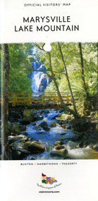
Map (Item) - Tourist map, Mystic Mountains Tourism, OFFICIAL VISITORS' MAP MARYSVILLE LAKE MOUNTAIN, Unknown
A visitors' map of Marysville and Lake Mountain produced by Mystic Mountains Tourism for Visit Victoria.A visitors' map of Marysville and Lake Mountain produced by Mystic Mountains Tourism for Visit Victoria.The Marysville and Lake Mountain Visitor Map and Touring Guide has been compiled and/ published by Mystic Mountains Tourism Inc. Copyright./ Production and artwork Graph Attack P/Lmarysville, lake mountain, victoria, australia, visitor's map, official visitors' map marysville lake mountain, buxton, narbethong, taggerty, visit victoria, mystic mountains tourism inc, graph attack p/l, mystic mountains, marysville triangle, marysville visitor information centre, marylands country house, black spur, steavenson falls, lady talbot drive, cambarville, cathedral ranges, wirreanda festival, lake mountain summit walk, summit walk loop, leadbeaters loop, day loop walk, buxton hotel, igloo roadhouse, karmann waters, silverstream b&b cottages, buxton trout and salmon farm, the niche wine bar, buxton post office & general store, choppers buxton roadhouse, woodlands rainforest bungalows, chestnut glade, black spur inn, wombat cottage, abbey lake luxury b&b spa cottages, mystic mountain ski hire & outdoors, pnl 4wdriving, blue views holiday units & ski hire, marapana agistment park & farm stay b&b, danico design, things of sand & stone, mantirri blueberry farm, allawah country cottages, amberview cottages, ashlar cottage b&b, black spur motel & caravan park, blackwood deluxe cottages, blackwood courtyard b&b, dalrymples guest cottages, delderfield, el kanah guest house, fruit salad farm, kerami guest house, keppels hotel, lake mountain-snow gum lodge, lomatia lodge, lyell guest cottages, magnolia house, keppel waters, lyrebird apartments, marysville caravan park, all view spa apartments, riverside cottages, maryton park b&b country cottages, melina cottage, mountain lodge, mystic mountains holiday cottages, nanda binya lodge, rendezvous luxury cottages, scenic b&b motel, the cumberland, south cathedral farm, tower motel, willowbank at taggerty, woodlands rainforest retreat, marysville & district country club inc, mystic mountains ski hire & outdoors, rubicon valley horse riding, marysville trout and salmon ponds, gallipoli park, keppels lookout, cambarville-yarra ranges national park, lake mountain-yarra ranges national park, lady talbot drive-yarra ranges national park, cathedral range state park, steavenson river, taggerty river, acheron river, lake mountain alpine resort, bruno's art and sculpture garden, manical mechanicals, uncle fred & aunty val's old style lolly shop, carmyle farm boutique, crossways historic country inn, fraga's, gilberts restaurant, heights licensed bistro, the old woolshed cafe, cathedral view natural therapies, crystal journey -
 Port of Echuca
Map - Navigational Chart
river chart, captains, murray river navigation -
Port Melbourne Historical & Preservation Society
Map - MHT General Plan showing Harbour improvements recommended Sir John Coode, Thomas Kell Lith, 1800s
Black and white map "Melbourne Harbour Trust, General Plan showing Harbour improvements, as recommended by Sir John Coode in his report of 17th February 1879" Showing proposed Coode canal and Sandridge, Hobson's Bay, North Williamstown, Footscray, the City, Emerald Hill and also the buildings of "Kitchen and Son" . (copy of original)industry, manufacturing, engineering department, borough of sandridge, engineering - canals and drainage, melbourne harbor trust - port of melbourne authority, j kitchen & sons pty ltd, sir john coode -
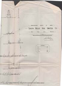 Bendigo Historical Society Inc.
Map - STRUGNELL COLLECTION: UNDERGROUND SURVEY OF MINES, BENDIGO, 29-3-01
Map, Underground Survey of Mines, Bendigo, South Belle Vue United Co.,New Chum Line.Transverse Section. Signed H.S.Whitelaw29.3.01 Drawing appears to show samples of connecting horizontal shafts with their respective mineral contentsH.S.Whitelawmap, bendigo, south belle vue united co.. -
Bendigo Historical Society Inc.
Map - HEATHCOTE : COUNTY OF BENDIGO, 19-2-1942
Map. Heathcote, County of Bendigo. County of Dalhousie, McIvor Creek,Wallan and Bendigo Railway, By authority H.E. Daw, Government Printer, Melbourne. Drawn and reproduced at the Department of Lands and Survey, Melbourne. 19-2-1942. Price 2/-. (number 90 in map cupboard 1)H.E. Daw, Government Printer, Melbourne.map, bendigo, heathcote -
Bendigo Historical Society Inc.
Map - REDESDALE : COUNTY OF BENDIGO, 25 -10-77
Map. Redesdale, County of Bendigo, County of Dalhousie, County Of Talbot, Lyell, Kimbolton, Langwornor, Spring Plains, Glenhope, Emberton, Metcalfe, Hawkestone, River Coliban, Campaspe River, Back Creek. Photo-Lithographed at the Department of Lands and Survey, Melbourne by J. Noune, 25-10-77. Compared with original plans 12-11-78 M. Kemp. J.C.Kelsh, Draughtsman April 1876. Examined by E. Downward, 5-6-77. (number 121 in map cupboard 1)J. Nounemap, bendigo, redesdale -
Whitehorse Historical Society Inc.
Map, Proposed layout at car park for Mitcham RSL, 14/12/1972
Plan of car park for proposed Mitcham RSL, McDowall Street, Mitcham.Plan of car park for proposed Mitcham RSL, McDowall Street, Mitcham. Architect: L.R.Saward. Amended 19 Feb.1973. Approved by Nunawading Council 16 Mar 1973.Plan of car park for proposed Mitcham RSL, McDowall Street, Mitcham. mitcham returned servicemens league, mcdowall street mitcham -
Stawell Historical Society Inc
Map, Gold Mines of Australia, Geological Plan Wonga Mine Area Stawell Investigation, 1950
Plans Showing Stawell Investment 1950Gold Mines of Australia Ltd mining, gold, map -
 Federation University Historical Collection
Map, Ballaarat Gold Field, 1861, 21/10/1861
A party of surveyors camped by Yuille's Swamp (later Lake Wendouree) and surveyed the countryside for a map to be produced by the Geological Survey of Victoria. In November 2004 the Central Highlands Regional Library presented a special edition of 200 copies of the 1861 map reproduced from a copy in their collection. Original geological map of Ballarat showing property, waterways, mines, churches, schools, water races, and garden reserves. It was compiled and drawn from the surveys of Mining Surveyors Davidson, Fitzpatrick and Cowan.Compiled & Drawn from the Survey of Mining Surveyors Davidson, Fitzpatrick and Cowan & the Plans in the Surveyor General's Office by J. Brahe, 21st October 1861. R. Brough Smyth, Secretary for Mines. The Honourable J.B. Humffray, M.L.A. Commr of Mines.ballarat, map, davidson, robert brough-smyth, fitzpatrick, cowan, yuille's swamp, public garden reserve, manure depot, black hill, ballarat east, old post office hill, pennyweight hill, claytons hill, golden point, mining, railway, cricket ground, swamp creek, cemetery, sludge reserve, bakery hill, gaelic church, juvenile reformatory, orphanage, specimen hill, eureka lead, cattle yard hill, dalton's flat, chinese village, poverty hill, railway reserve, little bendigo diggings, pound reserve, allied armies, flour mill, agricultural reserve, marsh, survey reserve, survey corps, white flat, yarrowee, yarrowee creek, brache, j. brache, survey, ballaarat gold field 1861 -
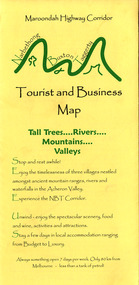 Marysville & District Historical Society
Map (Item) - Tourist and business map, Narbethong Community and Tourism Group, Narbethong Buxton Taggerty Tourist and Business Map, 04-2008
A tourist and business map of Narbethong, Buxton and Taggerty. This map was produced by the Narbethong Community and Tourism Group in April 2008. It was produced to promote the natural attractions, adventure activities and food trail from the Black Spur, through Narbethong, Buxton and Taggerty.A tourist and business map of Narbethong, Buxton and Taggerty.This publication has been produced by the Narbethong Community and Tourism/ Group (NCTG) to promote the natural attractions, adventure activities and food/ trail from the Black Spur, through Narbethong, Buxton and Taggerty./ the information provided in this publication has been supplied by the individual/ members. NCTG takes no responsibility for its accuracy./ April 2008narbethong, buxton, taggerty, victoria, australia, tourist and business map, narbethong community and tourism group, acheron valley, yarra track, wood's point, black spur, mystic mountains, the meeting of the waters, cathedral range, danico design counted cross stitch, things of sand & stone, buxton zoo nursery & oddz & enz, willowbank at taggerty, safe trek 4wd services, pnl 4wdriving, buxton trout and salmon farm, mystic mountains ski hire & outdoors, narbethong ski hire, highwood health centre, cathedral view natural therapies, narby cabinets, plants by shelian, gb timber, executive signs, rb automotive repairs, buxton car care, marysville towing & equipment hire, martyn slade building design, cathedral peak framing, black spur roadhouse & ski hire, tudor lodge roadhouse & ski hire, buxton roadhouse & persian bazzar, buxton post office general store & niche bar, igloo roadhouse, taggerty store, narby eggs, marapana agistment park, mantirri blueberry farm, carmyle farm, hazelwood hazelnuts, south cathedral lavender farm, cathedral cherries, black spur motel & caravan park, woodlands rainforest retreat, chestnut glade, black spur inn, wombat cottage, abbey lake luxury b & b spa cottages, blue views holiday cottages, camp narbethong, marapana farm stay b & b, mantirri blueberry farm b & b, little dene garden cottages, silverstream b & b cottages, nareen cabins, moondai farm b & b, south cathedral farm luxury b & b cottages, yarrolyn caravan park, sarsens rest, lomah retreat, pinjarra gardens, kingbilli country estate, henry viii manor house, buxton hotel, butters cafe of buxton, wagtail wines, little river wines, lanterns at willowbank, wirrawilla rainforest walk, wilhemina falls, the cascades -
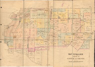 Bendigo Historical Society Inc.
Map - JACK FLYNN COLLECTION: NATTE YALLOCK, 22/06/1937
Map: Parish of Natte Yallock, Counties of Gladstone and Kara Kara. Parish plan.By Authority H.J. Green Government Printer Melbourne. Drawn and Reproduced at the Depart., of Lands and Survey, Melbourne, Victoria.map, gladstone, parish plan, natte yallock -
Bendigo Historical Society Inc.
Map - PANNOOBAMAWM : COUNTY OF BENDIGO, 7-9-15
Map. Pannoobamawm, County of Bendigo, Terrick Terrick East, Wanurp, Pannoomilloo, Bamawm,Turrumberry. By authority Albert J. Mullett, Government Printer, Melbourne. Photographed at the Deptartment of Lands and Survey, Melbourne. By W.J. Butson 7-9-15. Price 1/-. (number 81 in map cupboard 1)W.J. Butson, Government Printer, Melbourne.map, bendigo, pannoobamawm -
Moorabbin Air Museum
Map (Item) - Department of the Navy Hydrographic Office Air Navigation Chart No V30-57 South Pacific Ocean Australia and North East Seas and Islands
-
Federation University Historical Collection
Map - Map - Geological, Kejimkujik Lake, Nova Scotia: Geological Map 94-05, 1994
Produced by Nova Scotia Department of Natural Resources, Mines and Energy Branches. The Minister of the Department was the Honourable Donald R Downe and the Deputy Minister was Darrell D HiltzLarge coloured map depicting different areas and deposits. Includes a legend, symbols used, mineral abbreviations and alteration abbreviations.Symbolskejimkujik lake, nova scotia -
 Bendigo Historical Society Inc.
Map - JACK FLYNN COLLECTION: TOWNSHIP OF STANHOPE, December 1950
Map: Township of Stanhope, Parish of Girgarre, County of Rodney. Parish plan.By Authority J. J. Gourley, Government Printer, Melbourne. Drawn and Reproduced at the Dept, of Lands and Survey, Melbourne, Victoria.map, rodney, township, stanhope -
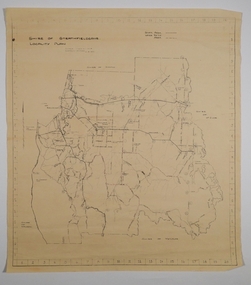
Whitehorse Historical Society Inc.
Map, Yarran Dheran Landscaping, 1974
Charts relating to landscaping Yarran DheranCharts of various dimensionsnon-fictionCharts relating to landscaping Yarran Dheranyarran dheran, thompson paul, landscape planning -
Stawell Historical Society Inc
Map, Bellellen, County of Borung, 1952
Bellellen, County of Borungstawell -
 Bendigo Historical Society Inc.
Map - BENDIGO AERIAL MAP 2007
Aerial map of Bendigo 2007 printed on vinyl. Written on bottom of map ' Australian Government Department of Defence photomap Bendigo Australia WGS84.aerial photo, bendigo map -
 Bendigo Historical Society Inc.
Map - CAMPBELL COLLECTION: BENDIGO AND DISTRICT MAPS, 21-8-1972
Map. Shire of Strathfieldsaye, Locality Plan. Scale I inch=1 mile. Shire of Huntly, Shire of McIvor, City of Bendigo, Shire of Marong, Shire of Maldon, Shire of Metcalfe. Lake Eppalock. Mileage markers on some roads. Melbourne to Bendigo Railway Line, Big Hill Tunnel, Mt.Herbert 1596.Axedale Township, Strathfieldsaye Township.M.Higgs 21-8-1972map, bendigo, locality plan -
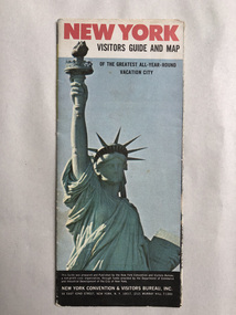 Robin Boyd Foundation
Map, New York Convention and Visitors Centre, New York Visitor Guide and Map: Of the Greatest All-Year-Round Vacation City, 1966
new york city, map, walsh st library