Showing 2398 items in the category Documentation with item type Map
-
 Stawell Historical Society Inc
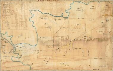
Map, Stawell Gold Field 1878, 1878
Stawell Gold Field 1878stawell, mining -
Lakes Entrance Historical Society
Map - Rainfall/Water Resources East Gippsland
Map shows catchment areas Macalister, Avon, Perry, Mitchell, Nicholson, Tambo Rivers and Lake Tyerswater resources, waterways, topography -
 Federation University Historical Collection
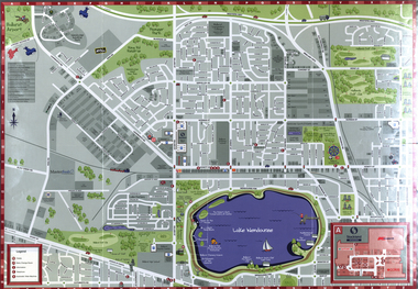
Map, Wendouree (Alfredton and Ballarat North) Retail and Business Guide, 2005, 10/2005
Wendouree, Alfredton and Ballarat North Retail and business guide mapmap, guide, wendouree, alfredton, ballarat north -
Whitehorse Historical Society Inc.
Map, Nunawading, 1972
Variation of original 1864 map with a number of additions and bold marking of an area including Forest Hill, Vermont and Vermont South as 'Proclaimed survey area No 21 May 1972 2826. Marked as P M Noting Melb SeriesVariation of original 1864 map with a number of additions and bold marking of an area including Forest Hill, Vermont and Vermont South as 'Proclaimed survey area No 21 May 1972 2826. Marked as P M Noting Melb Series.Variation of original 1864 map with a number of additions and bold marking of an area including Forest Hill, Vermont and Vermont South as 'Proclaimed survey area No 21 May 1972 2826. Marked as P M Noting Melb Seriesmaps, shire of blackburn and mitcham, forest hill, vermont, vermont south -
Bendigo Historical Society Inc.
Map - DIGGORRA PARISH : COUNTY OF BENDIGO, 6-9-21
Map. Parish of Diggorra, County of Bendigo, Parish of Bamawm, Rochester West, Pannoomilloo, Warragamba, Minto, Egerton, Elmore, Northern Railway, Parish of Ballendella. Elmore /Cohuna Railway. Photo-Lithographed at the Department of Lands and Survey, Melbourne by W.J. Butson, 6-9-21, Price 1/-.. By authority A.J. Mullett, Government Printer. (number 57 in map cupboard 1)A.J. Mullett, Government Printer.map, bendigo, diggorra -
Bendigo Historical Society Inc.
Map - SECTIONS ACROSS BENDIGO GOLDFIELD
Map in three sections showing sections across Bendigo Gold Field, showing anticlines, synclines, faults, stratigraphical zones and mines along the reef lines. Key shows rock types Castlemaine, Bendigo B1, B2, B3 and B4, and Lancefieldian. First part of map shows sections A-A, B-B and C-C. Reef lines drawn with mines listed: Fault line shown are the Carshalton, Stafford, New Chum, Virginia and Clarence. A datum line shows 600 ft above sea level. On bottom of plan: ' Prepared in the Geological Survey Office, Bendigo, under the direction of H. Herman, late Director of Geological Survey, from surveys by H.S. Whitelaw, Field Geologist, assisted by E.S. Usher, A.J.J. Moore and R.A. Keble.' Second section of map shows sections D-D, and E-E. Fault lines listed are the Tambour Major fault, Carshalton fault, Stafford fault, Nell Gwynne fault, New Chum fault, Deborah fault. Third section shows sections F-F and G-G. Fault lines listed are the Bird Reef fault, Kangaroo Gully fault, Langdon fault, Carshalton fault, Nell Gwynne fault, Spring Gully fault, Hustlers fault, Gravel Hill fault, Ordes fault, Thanet fault. This map forms part of the Geological Survey of Victoria, Structure of Bendigo Goldfield report, No. 47, 1923. H.Herman, late Director of Geological Survey.Geological Survey of Victoriabendigo, gold mining, reef line maps -
 Bendigo Historical Society Inc.
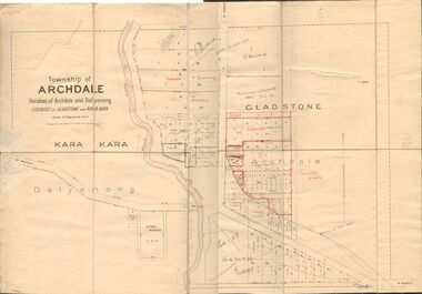
Map - JACK FLYNN COLLECTION: TOWNSHIP OF ARCHDALE, /08/1904
Map: Township of Archdale, Parishes of Archdale and Dalyenong, Counties of Gladstone and Kara Kara. Scale 4 Chains to 1 Inch. Has attached letters relating to land transfers between the Estate of Kate Sanderson and Barry Frederick Mortlock also between Matilda Jane Sanderson and A. O. Proctor.J. K. Spark Narrister & Solicitor, Formerly Mitchell, Monotti & Sparkmap, gladstone, township, archdale, dalyenong, gladstone, kara kara -
 Federation University Historical Collection
Map, Ballarat Goldfield, c1898
This map shows geological features, suggests the last basalt flow, and includes alotments and names of Mining Companies. Although this map has no date on it the Ballarat Industrial School is used for dating purposed. The Ballarat Industrial School ran from 1869-1879, but the term Ballarat Industrial School Reserve was still in use in 1898 and possibly beyond.Geological Map of Ballarat with 3 holes in the left hand side. The map indicates the position of Lake Wendouree, Township of Warrenheip, Ballarat East, Industrial School Reserve, Winters Swamp, Police Paddock, Wyndholm Premptive Right (Salton and Waldie), Black Hill, Vale Park Reserve, Pennyweight Hill, Little Bendigo, Black Swamp Lead, monte Christo Reef, Chinaman's Gully, Miners Rest, Pincotts Dam, Northumberland Gully. It also show the following goldmining companies: City of Ballarat, Kohinor, Hand and Band, Great North West, Northern Junction, Kneeshaw, Rossers Freehold, Silurial.ballarat, warrenheip, lake wendouree, ballarat east, winters swamp, winter swamp, wyndholm premptive right, cemetery, vale park reserve, little bendigo, kneeshaw co., industrial school reserve, kirks dam, pincotts dam, black hill, wombat hill, dead horse gully, miners rest, mt rowan, salton and waldie, rose hill co, great north west no 1, rose's freehold co, hand and band co, police reserve, police paddock, mount rowan, ballarat industrial school reserve, market reserve, winter's swamp, kneeshar co, monte cristo line of reef, chinaman's gully or black snake, milkmaid's gully, ballarat gold field, bakery hil lead, old gravel pits lead, golden point lead, eureka lead, miner's rest, yarrowee creek, leigh creek, black swamp lead, yorkshire reef, nil desperandum reef, cockatoo lead, hit or miss gully, herbert werner frederick de nully, pennyweight hill, esmond's lead, ash's lead, nightingale lead, john bull gully, gladstone reef, whitehorse reef, petticoat creek, pincott's dam, frenchman's gully, tim's crushing plant, jenkin's gully, california gully, drake's creek, sulton and waldie, ballarat undustrial school, ballarat & mariborough railway -
Merbein District Historical Society
Map, White Cliffs Irrigation Settlement - Plan of Homestead Allotments, 1917
homestead allotments, parish of merbein, county of karkarooc, blocks, irrigation settlement -
 Bendigo Historical Society Inc.
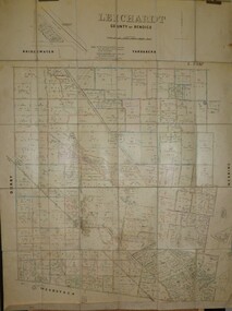
Map - JACK FLYNN COLLECTION: LEICHARDT, 14/03/1`939
Map: Parish of Leichardt, County of Bendigo. Parish plan.Drawn and Reproduced at the Dept, of Lands and Survey, Melbourne, Victoria. 14.3.1939map, bendigo, parish plan, leichardt -
 B-24 Liberator Memorial Restoration Australia Inc
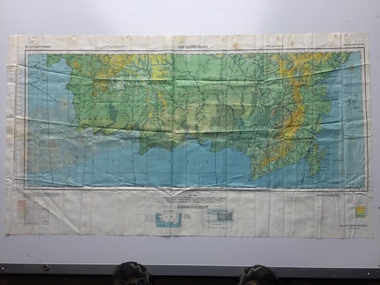
Map - US World War II multi-coloured map, Side 1 - No. C-47 South Borneo, Side 2 - No. C-48 West Java, 1944
Silk and rayon maps were produced by the United States (c. 7.5 million in total), Great Britain (some 1.75 million in total) and Australia during World War II. They were issued to Allied military personnel as part of 'escape and evasion' kits.This map, printed on acetate rayon, is an original US 'escape and evasion' kit map from World War II.A multi-coloured, contoured, double-sided map printed on acetate rayon AAF Cloth Chart Side 1 - No. C-47 South Borneo Side 2 - No. C.48 West Javaunited states of america, silk and rayon maps, world war ii, a191 -
Bendigo Historical Society Inc.
Map - TALAMBE : COUNTY OF BENDIGO, January 1956
Map. Talambe, County of Bendigo, Hayanmi, Dingee, Tandarra, Yallook, Pompapiel, Calivil. Drawn and reproduced at trhe Department of Lands and Survey, Melbourne. January 1956. Price 2/-. By authority W.M. Houston, Government Printer, Melbourne. (number 23 in map cupboard 1)W.M. Houston,Government Printer, Melbourne.map, bendigo, talambe -
 Kew Historical Society Inc
Map - Back to Kew 1875, Jesse Dannock, c.1931
The Kew Historical Society has an extensive collection of maps and plans; most relating to the former City of Kew (1860-1994). Within this collection, this hand-drawn map is unique.The most important and earliest original map of Kew in the collection, showing places of interest in early Kew.Hand-coloured map on heavy paper, depicting from Kew in 1875 from memory by Jesse Dannock. The map includes the names of local institutions and old residents. These, and many of the street names are very faded and have been overwritten with biro at a later date.maps - kew (vic), mrs dannock's map, cartography -
 Ringwood and District Historical Society
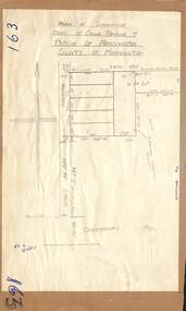
Map - Plan of Subdivision, Part of Crown Portion 7, Parish of Ringwood, County of Mornington - circa 1950
Hand-drawn map attached to light cardboard backing showing 5 residential allotments on eastern side of Maidstone Street Ringwood, north of Canterbury Road.RFK 8/11/51 -
Bendigo Historical Society Inc.
Map - CAMPBELL COLLECTION: BENDIGO AND DISTRICT MAPS
Map. Marong, Parishes of Marong, Lockwood and Mandurang. Scale 20 chains to an inch. Total 5106 acres. Compiled in W.P.B. from Field Survey and Parish Plans. Crusoe Reservoir to the right of map. (number 362 in map cupboard 1)map, bendigo, parish plan -
 Melbourne Tram Museum
Map, Metlink, "City of Moonee Valley - Local Travel Guide - July 2008", Sep. 2008
Map, Guide book, Pamphlet, 21 fold, pocket size, titled "City of Moonee Valley - Local Travel Guide - July 2008" detailing public transport services in the City. Includes map of the tram, train networks, tickets information, tram traction , Connex SMS updates and info on Metlink including contact details. Has a detail map showing services in the city and adjacent overlap area of buses, trams and trains including route numbers. See Reg Item 2250 for City of Boroondara version.trams, tramways, city of moonee valley, map, guides, bus services, metlink, connex -
Bendigo Historical Society Inc.
Map - KNOWSLEY : COUNTY OF BENDIGO, 7-11-1941
Map. Knowsley, County of Bendigo, County of Rodney, Weston, Axedale, Eppalock, Knowsley East, Langwornor, Heathcote, Campaspe River, Mt. Ida Creek or Wild Duck Creek, Sandhurst and Heathcote Railway, Kilmore-Heathcote-Bendigo Road. Knowsley Station Ground. Shingle Hut Creek, Forest Creek. By authority H.E. Daw, Government Printer, Melbourne. Drawn and reproduced at the Department of Lands and Survey, Melbourne. 7-11-1941. Price 2/-. (number 103 in map cupboard 1)H.E. Daw, Government Printer, Melbourne.map, bendigo, knowsley -
 Bendigo Historical Society Inc.
Map - FRED COWIE COLLECTION: AERIAL MAPS OF HEATHCOTE/EPPALOCK, 28-9-60
Map, Heathcote C3, Aerial Survey of Victoria, Photo-map prepared by Department of Crown Lands and Survey from photographs taken in 1960.Copied photographically at the Central Plan Office. Date 28-9 60, C.P.O.Neg. No.21588.Campaspe River, Coliban River. Flower Hill. Fred Cowie,46 McIvor Rd.Bendigo (Not located 29.9.2022)Central Plan Office.map, heathcote, fred cowie -
Stawell Historical Society Inc
Map, Agricultural Area of Lake Wilson, 1865
Agricultural Area of Lake Wilsonstawell -
 Robin Boyd Foundation
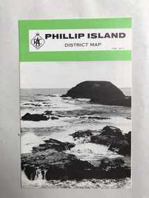
Map, RACV, Phillip Island District Map
walsh st library -
 Bendigo Historical Society Inc.
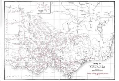
Map - RAILWAYS COLLECTION: 1946 RAILWAY MAP OF VICTORIA AUSTRALIA, 1946
Railways Collection-1946 glossy paper Railway Map of Victoria Australia Reproduced courtesy of V/Line by the Railway Museum North Williamstown Victoria 1988 price 3 pence. The maps shown are Railway Map of Suburban Lines Melbourne and Railways map of Victoria Showing Victorian Government Railways in red.map, victoria -
Bendigo Historical Society Inc.
Map - SALISBURY WEST, 14/10/1943
Map: Salisbury West, County of Gladstone. Parish plan ( number 179 in Map Cupboard 1)map, gladstone, parish plan, salisbury west , county of gladstone -
Port Melbourne Historical & Preservation Society
Map - Chart, Port Phillip, 1930
Photocopy in two large sections, of soundings chart for Port Phillip Bay, surveyed by Commander Henry L Cox RN, 1864, with corrections and additions to 1921. Top section (two copies)(Original had stamp of John Donne & Son Stationers)transport - shipping, hobson's bay, port phillip bay -
Bendigo Historical Society Inc.
Map - HUNTLY, SHEET 4, 29/03/1876
Map: Parish of Huntly, Sheet 4, County of Bendigo. Hand Draughted Parish plan. Originally in Map Cupboard. Relocated to Map Drawer 5 on 22.9.22. Too long for the map cupboard.map, bendigo, parish plan, huntly -
Whitehorse Historical Society Inc.
Map, Map 1892. Nunawading Shire, 1892
Duplicated same as ND5060 Map of Shire of Nunawading.Duplicated same as ND5060 Map of Shire of Nunawading. Shows railway line including spur from Box Hill to Box Hill Brick Co.Duplicated same as ND5060 Map of Shire of Nunawading. maps, shire of nunawading, railways, box hill brick company -
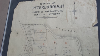 Peterborough History Group
Map - Map of the township of Peterborough, Township of Peterborough
Same map as 4012 but printed names are easier to read. Hand drawn arrows show the road now built connecting Macs St to the Warrnambool RdShows early layout of the town and names of landownersgovernment map of the township of Peterborough with handwritten notes on it. Includes the names of the landowners 1931some hand drawn arrows.peterborough, old maps, maps -
Lakes Entrance Historical Society
Map - Map of Tildesley West County of Tambo
Photocopy of map showing Lake Tyers, North Forest, Township of Nowa Nowa, Bass Strait.maps, townships, waterways, forest -
Bendigo Historical Society Inc.
Map - KANGAROO FLAT, 27/.01/1932
Map: Township of Kangaroo Flat, Parish of Sandhurst, County of Bendigo ( number 148 in Map Cupboard 1)map, bendigo, township, kangaroo flat, parish of sandhurst, county of bendigo -
Stawell Historical Society Inc
Map, Victorian Topographic Map Ledcourt
Topographic Map 1:25000 Coloured 1985Ledcourt 7424-3-3 Zone 54 VicMapmapping -
Bendigo Historical Society Inc.
Map - GOLDEN SQUARE GEOLOGICAL SURVEY, 1992
BHS CollectionGolden Square Geological Survey of Goldfields Coloured map.Dept of manufacturing and Industry Development.bendigo, gold mining, geological survey