Showing 2372 items in the category Documentation with item type Map
-
 Bacchus Marsh & District Historical Society
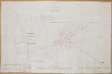
Map, Plan of the Village of Melton
A single page paper map showing a plan for the village of Melton, Parish of Djerriwarrh, County of Bourke. The map is pasted into a bound volume containing 76 maps or plans in total. High resolution digital image stored on BMDHS computer network. melton victoria maps -
 Melbourne Tram Museum
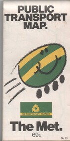
Map, Metropolitan Transit Authority (MTA), "Public Transport Map", c1984
Fold out map (36 sections 9 across x 4 deep), "Public Transport Map", coloured of Melbourne's Tram and Bus routes, route numbers, rail lines, detailed for the central part of Melbourne and the outer Metropolitan services. Includes description of tram and bus routes, private bus routes. On the front cover is The Met's Buzz symbol and their logo. Has contact details for bookings and lost property etc and how to use the map. Priced at 69c, issue No. 13 of c1984. Two copies held.trams, tramways, melbourne, map, tram & bus services, railways, the met, neighbourhood tickets -
 Robin Boyd Foundation
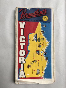
Map, Broadbents, Victoria
A well used large one sided map, which has been sellotaped down the centre.walsh st library -
 Bacchus Marsh & District Historical Society
Map, Plan of the property of Messers Atkins and Clarke to be sold at the Mansion, Bacchus Marsh 19th April 1856. Copy 1
This plan of land allotments for sale indicates the property once owned by the Bacchus family in and around the township area of Bacchus Marsh. The Bacchus family sold their property in Bacchus Marsh to John Atkins and Robert Nalder Clarke in March 1851. Atkins and Clarke kept the property for a number of years until April 1856 when these allotments were put up for sale.This plan is almost identical to another copy held by the Bacchus Marsh and District Historical Society, VC Record 452, BMDHS collection). This plan, VC Record 707 Copy 1, contains a little more detail overall than VC Record 452 Copy 2, such as who did the survey work for the plan (R.C. Bagot) and who the selling agents were, (W.M. Tennent), and on the right side of the plan near the Lerderderg River is indicated the general area for a second parcel of land from this sale which is to be sold. There is also a compass illustration indicating north and south compass points.This is a very early land sales plan for the township of Bacchus Marsh and it therefore provides some clues as to how the early urban development of the township took place. Upon seeing the map in 1911 Bacchus Marsh Express newspaper editor Christopher Crisp wrote "The sale appears to have created the present township, which had a nucleus in earlier times further east", Express, 30 September, 1911, page 3.A single page paper plan showing allotments of land for sale. The subdivided land shown was owned by John Atkins and Robert Nalder Clarke, but previously owned by the Bacchus Family and was in and around their Manor House (Mansion) property in Bacchus Marsh.There are 5 portions of land further divided into numerous small portions. The land for sale is bounded by the present day streets of Main Street, Young Street, McFarland Street, Morton Streets, Crook Street, and part of the eastern section extends to the Lerderderg River. Scale: 8 chains to 1 inch The plan is pasted into a bound volume containing 76 maps or plans in total. BMDHS Loc: AR/B12/S4 Bacchus Marsh Township and Nearby Districts Maps Volume In-house Digital copies: BMDHS, Computer Network: Maps\Bacchus Marsh Township and Nearby Districts Maps VolumeHeading: Plan of the first portion of land. The property of Messers Atkins and Clarke situate at Bacchus Marsh. To be sold by W.M. Tennent & Co. at the Mansion on the Ground on Saturday the 19th April 1856. Below heading: Jas Ferguson, Lithographer On upper right side: Subdivided by R.C. Bagot London and Liverpool Chambers, Melbourne. 'Thos Taubman'. Post Office Stamp: BACCHUS MARSH VICTORIA MY 6, 63bacchus marsh victoria maps, bacchus family, land sales, manor house bacchus marsh -
 Ringwood and District Historical Society
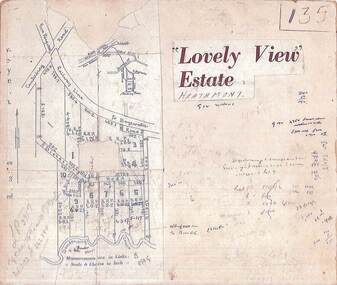
Map, Plan of Subdivision - Lovely View Estate, Heathmont, Victoria (Undated, circa 1930s)
Photocopied map from land sale brochure with handwritten real estate sales notations. Subdivision includes allotments on Dickason's Road and Allen's Road, Heathmont.LP3917 Part of Crown Allotments 14A-40A Parish of Ringwood. Vol 3232 Fol 626380. -
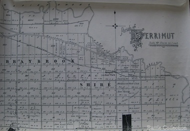 Melton City Libraries
Map, Parish of Derrimut, 1931
Map of the Parish of Derrimutcouncil -
 Bendigo Historical Society Inc.
Map - CAMPBELL COLLECTION: BENDIGO AND DISTRICT MAPS
Map. Mandurang, Parish of Mandurang, Scale 20 chains to 1 inch. Total area 5993 acres, Northern Railway to left of map, Water Reserve (Spring Gully). (number 363 in map cupboard 1)map, bendigo, allotments -
Stawell Historical Society Inc
Map, Shire of Stawell, 1963
Shire of Stawellstawell -
Whitehorse Historical Society Inc.
Map, Blackburn Lake - Elmore houses walk, 1/10/1991
Walking map, Ken Green. Copy 1 :Walking map, Ken Green. Copy 1 : Oct '91. See C-B 19 ND655 for copies marked 'November '91'.Walking map, Ken Green. Copy 1 : elmore houses, blackburn lake sanctuary, blackburn, the avenue, blackburn, laburnum street, blackburn, main street, blackburn, gardenia street, blackburn -
Bendigo Historical Society Inc.
Map - JANIEMBER WEST : COUNTY OF BENDIGO, September 1955
Map. Janiember West, County of Bendigo, Powlett, Janiember East, Jarklan, Kinypanial, River Loddon, Kelsh's Lagoon. By authority W.M. Houston, Government Printer. Drawn and reproduced at the Department of Lands and Survey, Melbourne. Price 2/-.September 1955. (number 64 in map cupboard 1)W.M. Houston, Government Printermap, bendigo, janiember west -
Stawell Historical Society Inc
Map, Victorian Topographic Map Illawarra
Topographic Map 1:25000 Coloured 1978Illawarra 7423-4-1mapping -
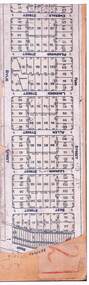 Ringwood and District Historical Society
Map, Subdivision Clipping, Ringwood, Victoria (Undated, circa 1930)
Trimmed photocopy showing layout of numbered allotments in Ford Street, Best Street, Leonard Street (later David Street), Allen Street, Lavender Street, Pearwood Street, Emerald Street and Great Ryrie Street (mis-named Rylie Street), Ringwood, Victoria. Also marks location of 27 soldiers home allotments in Bedford Road.Handwritten notations include land title reference - LP11818. -
Clunes Museum
Map - MAPS, 28/02/1971
ORIGINAL MAP - CLUNES CARAVAN PARKlocal history, document, maps, clunes township -
Whitehorse Historical Society Inc.
Map, Blackburn and Nunawading Map, 1960's?
Map of Blackburn and Nunawading.Map of Blackburn and Nunawading.Map of Blackburn and Nunawading.maps, blackburn, nunawading -
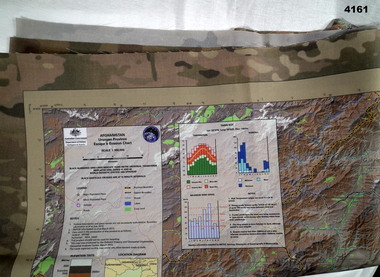 Bendigo Military Museum
Map - MAP of AFGHANISTAN, Australian Government department of defence, Details as of March 2013
Synthetics cloth coloured map of Uruzgan Province Afghanistan, scale 1: 300,000, Escape and evasion type. Has graphs, charts, elevations.maps, afghanistan -
Bendigo Historical Society Inc.
Map - PORTION OF ELMORE ESTATE, 19/10/1920
Map: Portion of Elmore Estate, Parish of Minto, County of Bendigo. Parish plan Canvas backed ( number 131 in Map Cupboard 1)map, bendigo, rural, elmore estate, minto, county of bendigo -
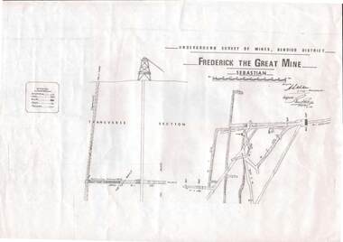 Bendigo Historical Society Inc.
Map - STRUGNELL COLLECTION: UNDERGROUND SURVEY OF MINES, BENDIGO DISTRICT, 7-1-99
Map, Underground Survey of Mines Bendigo District.Frederick the Great Mine, Sebastian. A collection of nine (9) maps of the mine, Signed H.S.Whitelaw Field Geologist 4.1.99 with some notes relating to same, including a: * Typed overview of the operation of the mine in 1912. * Clipping from Victoria its Mines and Minerals detailing the operation of the mine from its beginning in 1863 where it was first worked for alluvial. Charlton & Co., and Mr. Glass mentioned in article.A.S.Whitelawmap, bendigo, frederick the great mine -
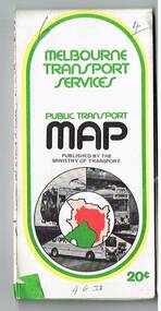 Melbourne Tram Museum
Map, Ministry of Transport, "Melbourne Transport Services Map - Tram, Train and Bus Services", 1975-1976
Fold out map (27 sections 9 across x 3 deep), coloured of Melbourne's Tram and Bus routes, route numbers, rail lines, detailed for the central part of Melbourne and insert section for Frankston. On rear description of routes, private bus routes and map of Melbourne metro lines. Has contact details for bookings and lost property etc. Priced 20c possible 1975-1976 - has 1041 and silver train on front cover.On front cover in ink "3" in top right hand corner and "4 G 33 " along bottom edge.trams, tramways, melbourne, map, tram & bus services, railways, mmtb, minister for transport -
Whitehorse Historical Society Inc.
Map, Mitcham, 1880s?
Hand drawn map of area north and south of Whitehorse Road and South of Canterbury Road c.1880-1900.Hand drawn map of area north and south of Whitehorse Road and South of Canterbury Road c.1880-1900. Probably sketched by a McClare descendant. Includes locations and names of settlers of that time.Hand drawn map of area north and south of Whitehorse Road and South of Canterbury Road c.1880-1900. whitehorse road, mitcham, mitcham road, mitcham, l l vale road, vermont, canterbury road, mitcham -
Bendigo Historical Society Inc.
Map - HAWKESTONE, 17/11/1915
Map: Hawkestone, County of Talbot. Parish plan ( number 178 in Map Cupboard 1)map, talbot, parish plan, hawkestone, county of talbot -
 Ballan Shire Historical Society
Map - Map. Ballark, Department of Lands and Survey, Ballark. County of Grant, 31/08/1915
A map of the Ballark area within the County of Grant showing roads, waterways, property boundaries and property owners in 1915.Significant to people researching land usage and ownership. Also those researching families in the area at that time.A map of Ballark in the County of Grant. Black printing on buff coloured paper. Extra notations by hand and various coloured highlighting of certain features. Details roads, rivers, property boundaries and names of property owners and districts. The map is easily readable although there is some physical damage to the borders and some sellotape residue. Shows a scale in Chains and the number L.6030Various numbers and directional arrows added to map.bungal, borhoneyghurk, bungeeltap, ballark, beremboke, moreep, meredith, morrisons, moorarbool river -
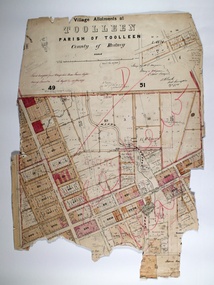 Bendigo Historical Society Inc.
Map - TOOLLEEN ALLOTMENTS, circa 1870
Map: Parish plan showing Village allotments at Toolleen, Parish of Toolleen, County of Rodneymap, rodney, toolleen, parish of toolleen, county of rodney -
 Bendigo Military Museum
Map - TRENCH MAPS, FRANCE, 38th BN ON THE SOMME, 1).2) 1918, .3) system generated
The story covers mostly men of C Coy 38th Bn as well as others to give a broader pictutre. Edgar Stanbury MM as a C Coy Scout retrieved the maps from Capt G.A Dutton who was KIA. Stanbury then proceeded to keep reconnoitering towards Clery until they reached trenches near Clery Copse. The photos relate to the following, Jack Grinton, Bert Grinton, Edgar Stanbury, C.E. Newton, D.T.Hull, A.E.Pegler, Albert Gilhooley, C.E.A.Dunn, Hugh Pippin, G.A.Dutton, C.J.Holmes, Capt Selleck, Major Maudsley, last photo is labelled “Past Clery Copse”. Jack Grinton No 1043 C Coy, refer Cat No 1280. Bert Grinton No 5024 C Coy, awarded DCM 31.8.1918, refer Cat No 1320P. Edgar Stanbury No 997 C Coy, awarded MM 1917, WIA 2nd occasion 31.8.1918, refer Cat No 5032.3P. Charles Newton No 951 C Coy, awarded MM 26/31.8.1918. David Hull No 904 C Coy, Gassed 24.8.1918. Albert Gilhooley No 890 C Coy, KIA 31.8.1918, refer Cat No 5047. Augustus Pegler No 967 C Coy, awarded MM 31.8.1918. Cyril Dunn No 3058 7th Reo’s C Coy, KIA 31.8.1918. Hugh Pippin No 1895 2nd Reo’s C Coy, WIA 2nd occasion 11.8.1918, refer Cat No 1502. George Dutton Lieut No 532 C Coy, KIA 29.8.1918. (Photo of his name on Map & note to Jack Grinton) Charles Holmes No 910 C Coy, KIA 24.8.1918. (Photo of original grave) Horace Selleck Capt C Coy, KIA 19.7.1918, refer Cat No 1515. (Photo of address book) Arthur Fyfe No 1841 2nd Reo’s C Coy, KIA 30.8.1918. (Photo of original grave) Arthur Maudsley Major D Coy, KIA 31.8.1918. (Photo of original grave) Fyfe, Maudsley and Duttons graves are in the one photo. Last photo labelled “Past Clery Copse” This is the area where Bert Grinton is awarded the DCM on 31.8.1918, photo was taken by his brother Jack. .1) Map of France, trenches corrected to 15.4.1918, 1/20,000, Sheet 62D N.E, covers an area from Ribemont to Bray. .2) Map of France, trenches corrected to 6.3.1918, 1/20,000, sheet 62C N.W, covers area from Suzanne to Mt St Quentin. Both maps follow the Somme River. .3) Photo - story covers the events relating to the two maps from July 17th. - Sept 1st 1918 on the Somme . There are 14 photos with the story, 3 sections make up the story, Map 1, Map 2 and then details on the advance, the men, casualties and other.maps, 38th bn, c coy, the somme -
Lakes Entrance Historical Society
Map - Survey Mt Barkly Gippsland Lakes
Survey No 1 Diagram Plan of Survey at Mt Barkleysurveying, plan -
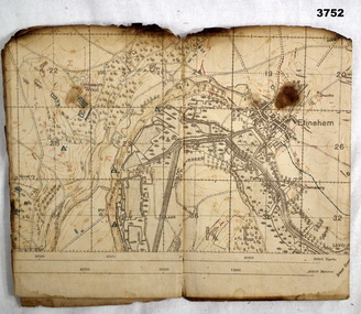
 Bendigo Military Museum
Map, 1917
Area of map covers the Somme from Suzanne, Clery, Perone then onto Doingt, Rosiel, Ronssoy. Item re William Alexander No 502 AIF. Refer Cat No 3746.3 for his service details. Map, France, Ordnance survey May 1917, Edition 1, sheet 62c, scale possibly 1:20,000. On rear is a glossary of terms French to English.map, trench, france -
Bendigo Historical Society Inc.
Map - REDESDALE, See above
Map: two maps on either side of backing, (1) Township of Redesdale, Parish of Redesdale. (2) Surban lands, Parish of Spring Plains, County of Dalhousie. Date are 26th May 1873 and 12/07/1909 ( number 157 in Map Cupboard 1)map, dalhousie, township, redesdale, parish of spring plains, county of dalhousie -
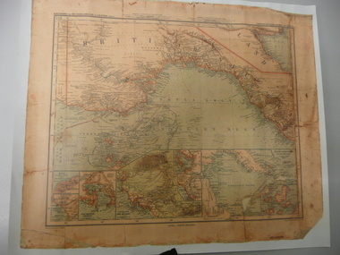 Bendigo Historical Society Inc.
Map - STRAUCH COLLECTION: MAP BRITISCH PAPUA
Copy of original heritage map of ''Britisch Papua'' (N.G.) detailed & mapped by German (marine navigator) 'Gezeichnet von C.Barich & produced in the 'Langhans Deutscher Kolontal Atlas, Feb. 1893. Presented to German Society, 30.5.2008 by Mr P.Thwaites, Plans & Projects Officer (Digo 2008) Plus Society's laminated work copy of same map.map -
 Bendigo Military Museum
Map - TRENCH MAP, FRANCE WW1, 1918
Areas covered on this map, “Ribemont, Morlancourt, Dernacourt, Fricourt, Mericourt, Saily Le Sec” Item re William Alexander No 502 AIF. Refer Cat No 3746.3 for his service details.Trench map, France, Edition 2 E, sheet 62D N.E, scale 1:20,000, trenches corrected to 28.5.1918, German trenches in red, British in blue.map, france, trench -
Glenelg Shire Council Cultural Collection
Map - Map - Paper Survey, n.d
Paper survey map, ink and watercolour, framed under glass. Painted black gloss. Shows Fawthrop lagoon and surrounds including Fawthrop's home 'Windsor Cottage', outbuildings and garden, Cairncross and Howard holdings and othersBack: 'Town of Portland' -
Stawell Historical Society Inc
Map, Blue Print of Central Park, Stawell
Blue Print of Central Park, Stawellstawell, sport