Showing 2186 items
matching documentation
-
 Melbourne Tram Museum
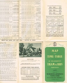
Map, Melbourne & Metropolitan Tramways Board (MMTB), "Map and timetable of Melbourne Tram and Bus Services" - May 1956", May. 1956
Fold out map (10 sections), coloured of Melbourne's Tram and Bus routes, route numbers, rail lines, municipalities boundaries and location of major places of interest. Titled - "Map and timetable of Melbourne Tram and Bus Services" - May 1956". At base of map - timetable of all night trams and bus services. On rear index to routes, 1st and last services, time of Sunday am services, LaTrobe St. services and photo of Wattle Park. Dated May 1956. Note the inset map shows Bourke St as a bus. Three copies held. 413.1 - as for above but with a pasted over section titled "Time table of all - night bus services" on the base of the map replacing the all night tram and bus services. Dated 3/7/1957. Copy from donation of Gary Butler added 3/12/15. See Reg Item 2300 for the March 1952 version.trams, tramways, melbourne, map, tram & bus services, all night services, mmtb -
 Whitehorse Historical Society Inc.
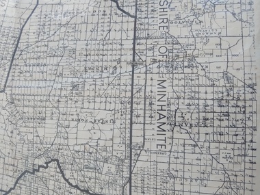
Map, Mitcham Riding, n.d
Shire of Nunawading: Mitcham Riding [n.d.] (between Springvale and Mitcham Roads) (Shows electric light mains. MMBW reserves, railway line.)mitcham, maps, tunstall, forest hill -
 Bendigo Historical Society Inc.
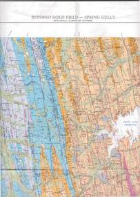
Map - STRUGNELL COLLECTION: GEOLOGICAL SURVEY OF VICTORIA, BENDIGO GOLD FIELD - SPRING GULLY, 1987
Map, Geological Survey of Victoria, Bendigo Gold Field - Spring Gully, Campaspe 10 000 2/1; Victoria 10,000.Cept. Of Industry, Technology & Resources.map, bendigo, spring gully gold field -
 Ballan Shire Historical Society
Map - Map. Bullarook State Forest, Bullarook State Forest Reserve
A small map of the Bullarook State Forest Reserve. Drawn on a fine buff coloured paper attached to a stiff cloth backing sheet. The title is hand written and includes a "scale one mile to one inch" hand written also. The map is signed "John Wrigglesworth, assistant ? and dated 26/6/1869" although the month and year are almost illegible.moorabool west, state forest, bullarook, eastern moorabool river, werribee river, moorabool east, blakes saw mill, wombat, andersons saw mill -
 Bendigo Historical Society Inc.
Map - SANDHURST, SHEET ?, Date missing
Map: Sandhurst (sheet No., Missing) P_arish planmap, bendigo, parish plan, sandhurst -
Merbein District Historical Society
Map, State Rivers & Water Supply Commission-Merbein Urban District n.d, unknown
state rivers and water supply commission, merbein township -
Bendigo Historical Society Inc.
Map - CITY OF SANDHURST SHEET NO.6, 25/04/1882
Map: City of Sandhurst sheet No. 6. Parish planmap, bendigo, parish plan, sandhurst -
Bendigo Historical Society Inc.
Map - CAMPBELL COLLECTION: BENDIGO AND DISTRICT MAPS
Map. Block plan key, Bendigo and surrounding districts including : Sandhurst, Nerring, Huntly, Neilborough, Salisbury, Yarrayne, Bridgewater, Yarraberb, Derby, Leichardt, Tarnagulla, Marong, Woodstock, Shelbourne, Lanecoorie, Lockwood, Ravenswood, Mandurang, Sedgwick, Kimbolton, Eppalock, Strathfieldsaye, Axedale, Wellsford, Ellesmere, Bagshot, Goornong, Nolan, Whirrakee, Egerton, Minto. (number 347 in map cupboard 1)map, bendigo, allotments -
Bendigo Historical Society Inc.
Map - RESURVEY PARISH OF SANDHURST, 23/07/1891
Map: Resurvey, Parish of Sandhhurst sheet No. IV, Enlargement of part of sheet No. III. Parish plan ( number 204 in Map Cupboard 1)map, bendigo, parish plan, parish of sandhurst, resurvey -
 Melbourne Tram Museum
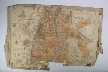
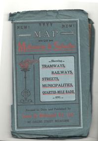
Map, Sands McDougall, Map of Melbourne and Suburbs showing Tramways, Railways, Streets, postal districts, Quarter-Mile Radii etc", c1922
Shows railways, cable and electric tram lines c1922. One of a number of maps produced by Sands McDougall of Collins St. Includes the Zoo horse tram lines. See acquisition and Research note by Duncan McAuslan. See items 2885, 6573, amd 6917 for other editions. On inside cover has current postal rates (including a war surcharge) and places worth visiting and on the rear cover, is an advertisement for Imperial ink.Yields information about Melbourne c1922 and its public transport lines. Produced by Sands and McDougall Pty Ltd of Collins St Melbourne. Folded sheet of paper 6 sections wide x 6 sections or folds deep contained within a green paper cover titled "Map of Melbourne and Suburbs showing Tramways, Railways, Streets, postal districts, Quarter-Mile Radii etc", showing both cable and electric tramways. maps, melbourne, cable trams, tramways, railways, horse trams, vr trams, sands mcdougall, zoo horse tramway, mmtb -
Bendigo Historical Society Inc.
Map - ELMORE, 2/03/1880
Map: Parish of Elmore, County of Bendigo. Parish plan. (number 344 in map cupboard 1)map, bendigo, parish plan, elmore -
Bendigo Historical Society Inc.
Map - CAMPBELL COLLECTION: BENDIGO & DISTRICT MAPS, 22-3 29
Map. Marong, Parishes of Marong, Lockwood and Mandurang. Scale 20 chains to an inch. Total area 5106 acres. Crusoe Reservoir on right. Compiled in W.P.B. from Field Survey and Parish Plans (number 373 in map cupboard 1)G.W.Lmap, bendigo, allotments -
Bendigo Historical Society Inc.
Map - CAMPBELL COLLECTION: BENDIGO AND DISTRICT MAPS, 15-2-29
Map. Nerring, Parish of Nerring, scale 20 chains to 1 inch. Prepared in W.J.B. from A and B plans by W.J. Galbraith 15-2-29. (number 356 in map cupboard 1)W.J.Galbraithmap, bendigo, parish plan -
University of Melbourne, Burnley Campus Archives
Map - Geological map, Melbourne and Suburbs, 1959
Geological map of Melbourne, 1959, modified by officers of the Geological Survey of Victoria, from earlier geological surveys. Scale 1:31.680melbourne metropolitan area, geology, geological survey of victoria, department of mines -
Bendigo Historical Society Inc.
Map - CAMPBELL COLLECTION: BENDIGO AND DISTRICT MAPS, 1982
Map. Forest Commission Victoria, Bendigo Forest District, Sub-Plan 1 District Fire Prevention Plan, Greater Bendigo Area. Prevention Strategy Plan. Shire of Marong, Shire of Huntly, Borough of Eaglehawk, Shire of Strathfieldsaye, Sailors Gully, Epsom, Jackass Flat, White Hills, California Gully, Maiden Gully, Long Gully, North Bendigo, City of Bendigo, Bendigo East, Kennington, West Bendigo, Golden Square, Quarry Hill, Flora Hill, Spring Gully, Kangaroo Flat.Base prepared 1982. (number 397 in map cupboard 1)map, bendigo, forest district -
Merbein District Historical Society
Map, Mildura and District Map, After 1954
merbein, yelta, merbein south, the lake, merbein west, birdwoodton -
Bendigo Historical Society Inc.
Map - BENDIGO, GREATER CITY OF, 2013
Map, City of Greater Bendigo, Epsom/Huntly, Heathcote, Strathfieldsaye/ Junortoun, Mandurang, Sebastian, Mia Mia, Maiden Gully, Ravenswoon, Axedale, Myers Flat, Redesdale, September 2013, on front. Lockwood South, Marong, Raywood, Neilborough, Elmore, Goornong, on reverse side. ( number 413 in Map Cupboard 1 ). Donated by Bendigo Council.bendigo, hospital -
 Peterborough History Group
Map - Shire of Warrnambool
Map of the area, when Peterborough was part of Warrnambool ShireHistoric map of the area when Peterborough was in the Warrnambool ShireA3 size map, larger view of the whole shire of Warrnambool, and includes adjoining Shire Boundaries. Shows individual land allotments.peterborough, warrnambool shire, old maps -
Whitehorse Historical Society Inc.
Map, Springvale Road, 1990
Aerial photograph of cnr Springvale Road and Burwood Highway, south past Highbury Road, west to Middleborough Road and east to Morack Road Vermont South.Aerial photograph of cnr Springvale Road and Burwood Highway, south past Highbury Road, west to Middleborough Road and east to Morack Road Vermont South.Aerial photograph of cnr Springvale Road and Burwood Highway, south past Highbury Road, west to Middleborough Road and east to Morack Road Vermont South.aerial photographs, morack road, vermont south, burwood highway, burwood east, springvale road, burwood east, highbury road, burwood east, burwood east, vermont south -
 Melbourne Tram Museum
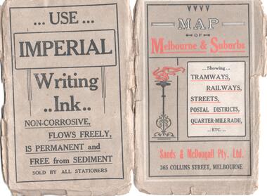
Map, Sands and McDougall Pty Ltd, "Map of Melbourne and Suburbs showing Tramways, Railways, Streets, postal districts, Quarter-Mile Radii etc", c1930
Produced by Sands and McDougall Pty Ltd of Collins St Melbourne. Map - folded sheet of paper 5 sections wide x 6 sections or folds deep contained within a dark grey paper cover titled "Map of Melbourne and Suburbs showing Tramways, Railways, Streets, postal districts, Quarter-Mile Radii etc", showing both cable and electric tramways. verted, but not Market St to Port Melbourne or South Melbourne. Shows the Collins St line being constructed. Collins St routes were opened late 1929, map produced during the early 1930's prior to the closure of Market St - Port Melbourne. Has a detailed list of the postal districts.trams, tramways, maps, melbourne, cable trams, tramways, railways -
Whitehorse Historical Society Inc.
Map, Map of the City of Nunawading, c1960, c1960
Map of the City of Nunawading prepared by Drake & Co, Real Estate Agents in about 1960.city of nunawading, drake & co, maps -
 Queenscliffe Maritime Museum
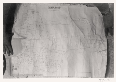
Map - French Island, County of Mornington, French Island map photographs x 2, c1987
Islands off Victorian coastFrench Island mapFrench Island map photographs x 2Reverse " Nil "french island -
Bendigo Historical Society Inc.
Map - JOHN WILLIAMS COLLECTION: PHOTO-MAP OF BENDIGO, 2007
Map, Photo-map of Bendigo,Australian Government Department of Defence,prepared and published by the Defence Imagery and Geospatial Organisation 2007.Copyright Commonwealth of Australia 2007.Australia Photomap 1:15 000. Edition 2-DIGO. WGS84.Grid 1000 metre UTM Zone 55. (number 407 in map cupboard 1)Defence Imagery & Geospatial Organisationmap, bendigo, city streets -
Bendigo Historical Society Inc.
Map - CITY OF SANDHURST RESURVEY SHEET NO. 3, 13/05/1881
Map: City of Sandhurst Resurvey sheet No. 3. Parish plan.map, bendigo, parish plan, sandhurst, resurvey -
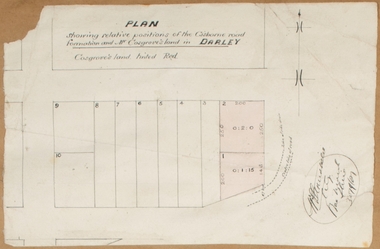 Bacchus Marsh & District Historical Society
Map, Plan showing relative positions of the Gisborne road formation and Mr. Cosgrove's land in Darley. 1907
No background information about the roadworks referred to in this plan has been found. The portion of land referred to as 'Cosgroves' in this plan is located close to the present day Darley Park Recreation Park in Darley, near Bacchus Marsh. The land indicated appears to be close to the corner of Grey Street and Gisborne Road. James Cosgrove who died in 1923 aged 65 owned a farm of 52 acres in this area of Darley.Single page map showing a proposed deviation of the Gisborne road in Darley and its position relative to land owned by Mr. Cosgrove. The land owned by Cosgrove is shaded in pink. No scale indicated. Part of a set of maps which are pasted into a bound volume containing 76 maps or plans in total. High resolution digital image stored on BMDHS computer network. Signature (illegible), Eng, Bac Marsh Shire, 30/9/07bacchus marsh roads and streets, darley victoria maps -
 Ringwood and District Historical Society
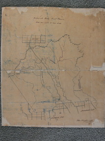
Map, Plan of Country Lands in the Parishes of Nunawading Ringwood and Scoresby - circa 1855
Blueprint copy of Survey Map detailing original Selectors' names and property locations. List of Parish map references including property bearings, distances in Links, and markings on trees. Descriptive remarks include areas marked "Farmer's Common", "Poor soil thickly/moderately timbered with stringy bark", and location of water and firewood reserves."Surveyed and plotted by N.M. Bickford, Superintendant of Mr. Hodgkinson's Field Party". "The land comprised in this survey is of inferior quality, moderately undulating, and thickly wooded. It is watered by Dandenong Creek and Deep Creek." Inset map showing location of (*proposed) cemetery on southern corner of Lillydale Road from Melbourne and Sawmill Road, later Mount Dandenong Road. (*Cemetery did not eventuate.) -
 Bendigo Historical Society Inc.
Map - MINING PLAN ,VICTORIA HILL AREA, No date visible
Map: Large scale plan of an area of the Goldfield, Northward from Barnard Street, covering the Victoria Hill area. Black printing on polycarbonate film. Transparent.map, bendigo, mining plan, mining, gold mines, victoria hill, lines of reef -
 Bendigo Historical Society Inc.
Map - Geological survey of Bendigo Goldfields
Three Geological survey maps of the Bendigo Gold Fields joined together. The three sections are Eaglehawk, Golden Square and Spring Gully. It shows geological conditions, gold reef lines and mine sights. Three sections are laminated together. The maps were produced by the Victorian Department of Manufacturing and Industry Development geological survey, bendigo gold fields -
Stawell Historical Society Inc
Map, Special Surveys, District of Ararat, 1968
Special Surveys, District of Araratstawell -
Port Melbourne Historical & Preservation Society
Map - Route of US Navy Great White Fleet, 2008
Large photocopy of map of the world with the route of the Great White Fleet (US Navy) 1908 marked in red and white tapearmed services - navy, great white fleet, us navy