Showing 2258 items in the category Documentation with item type Map
-
 Bendigo Historical Society Inc.
Map - CITY OF BENDIGO RESURVEY SHEET NO. 3, Circa 1900
Map: City of Bendigo Resurvey sheet No. 3. Parish plan ( number 214 in Map Cupboard 1)map, bendigo, parish plan, bendigo, resurvey -
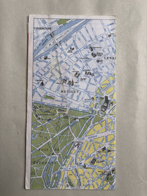 Robin Boyd Foundation
Map, Blondel La Rougery, Find Your Way in Paris, 1959
Map marking the Printemps department stores and significant urban landmarks in Paris; maps of Paris Metro and Autobus on reverse/ Blondel La RougerySmall scribbles on the advertising pages, indecipherable.paris, paristemp, map, transport map, walsh st library -
 Bendigo Historical Society Inc.
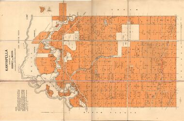
Map - JACK FLYNN COLLECTION: KANYAPELLA, 22/05/1939
Map: Parish of Kanyapella, Counties of Rodney and Moira. Parish plan.By Authority, T. Rider Acting Govt, Printer Melbourne. Drawn and Reproduced at the Dept. of Lands and Survey, Melbourne, Victoria.map, moira, parish plan, kanyapella, counties of rodney and moira -
Port Melbourne Historical & Preservation Society
Map - MMBW, 1897
Melbourne and Metropolitan Board of Works 1895, Plan No. 324, 328, 329 Segments shown: (as plan No's.) Large scale showing hotels, civic and industrial buildings, Graham Street to Bay, Nott and Dow Streets.engineering - board of works, business and traders - hotels, built environment, piers and wharves - town pier, transport - tramways -
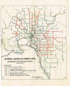 Melbourne Tram Museum
Map, Melbourne & Metropolitan Tramways Board (MMTB), "Proposals for General Scheme", 27/08/1923 12:00:00 AM
Map - drawing with a line back, titled "Melbourne and Metropolitan Tramways Board Proposals for General Scheme". Shows the proposed tram lines submitted to Parliament for the report into the General Scheme. Printed by Sands & McDougall Pty Ltd. Signed by J. P Strickland dated 27-8-1923. See Reg item 3374.2 for a better copy.trams, tramways, mmtb, general scheme, tramways, development, parliament, brighton, railways, map -
Bendigo Historical Society Inc.
Map - TARNAGULLA, 8/08/1912
Map: Tarnagulla sheet 2. Parish plan ( number 241 in Map Cupboard 1)map, talbot, parish plan, tarnagulla -
Whitehorse Historical Society Inc.
Map, Nunawading, c1850
Early map of Nunawading, Bulleen and part of Boroondara areas.Early map of Nunawading, Bulleen and part of Boroondara areas.Early map of Nunawading, Bulleen and part of Boroondara areas.shire of nunawading, bulleen, boroondara -
Stawell Historical Society Inc
Map, Stawell Gold Mine, Milling Area Site Arrangement 2002, 12/6/2002
Plus Bench Mark Levels Stawell Gold Mines Victoria Scale 1 : 20000mining, gold -
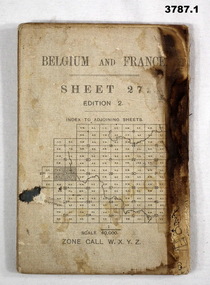 Bendigo Military Museum
Map - MAPS, BELGIUM WW1, 1912 - 1917
(.1) Areas covered on this map, Bollezeele to Poperinghe, Arques to Meteren. (.2) Areas covered on this map, BourBourg to Poelcapple, Reemilly to Armentieres. (.3) Areas covered on this map, Bruges, Neuzen, Ghent. (.4) Areas covered on this map, Alost, Loulain, Soignes, St Germain. (.5) Areas covered on this map, Roulers, Oosterzeele, Lille, Thoriecourt. Items relate to William Alexander No 502 AIF. Refer 3746.3 for his service details.(.1) Map, Belgium and France, sheet 27, Edition 2, scale 1:40,000, zone call W.X.Y.Z, Ordnance survey May 1917, gauze lined. (.2) Map, Belgium, Hazebrouck 5A, Edition 2, scale 1:100,000, Ordnance survey 1916, gauze lined. (.3) Map, Belgium, Ghent 2, scale 1:100,000, War Office June 1915. (.4) Map, Belgium, Brussels 6, scale 1:100,000, Drawn at War Office, Ordnance survey 1912. (.5) Map, Belgium, Tournai 6, scale 1:100,000, War Office Ordnance survey July 1912.(.1) On rear, “Glossary of terms”maps, belgium, france -
 Bendigo Historical Society Inc.
Map - UNITED HUSTLER'S & REDAN & K. K. MINES - PLAN OF UNITED HUSTLER'S & REDAN & K. K. MINES
Plan of the United Hustler's & Redan & K. K. Mines on the Hustler's Line of Reefs Bulletin No 33 Plate No XXVII. Plan shows depth of levels, Long Gully, Hustler's Line of Reefs, Lightning Hill Line of Reefs and approximate Boundary of Lease. Also mentions Comet Co. Geological Survey of Victoria emblem and signed by H S Whitelaw, Underground Survey Office Bendigo September 1913.mining, parish map, united hustler's & redan & k. k. mines, long gully, hustler's line of reefs, lightning hill line of reefs, comet co, h s whitelaw, geological survey of victoria, underground survey office -
Whitehorse Historical Society Inc.
Map, Legislative Assembly, 1984
State of Victoria Legislative Assembly electoral districts 1983 - 1984 redivision (Melbourne Metropolitan area) Scale 1:50,000State of Victoria Legislative Assembly electoral districts 1983 - 1984 redivision (Melbourne Metropolitan area) Scale 1:50,000State of Victoria Legislative Assembly electoral districts 1983 - 1984 redivision (Melbourne Metropolitan area) Scale 1:50,000victoria. parliament. legislative assembly, electoral boundaries -
Bendigo Historical Society Inc.
Map - RAVENSWOOD, COUNTIES OF BENDIGO & TALBOT, 12-12-22
Map, Ravenswood, Counties of Bendigo & Talbot, Shelbourne, Walmer, Harcourt, Sutton Grange, Mandurang, Lockwood.By Authority A.J.Mullett, Govt. Printer, Melbourne. Photo-Lithographed at the Dept. of Lands and Survey, Melbourne by W.J.Butson 12-12-22, Price1/-. (number 87 in map cupboard 1)A.J.Mullett. Govt. Printer, Melbourne.map, bendigo, ravenswood -
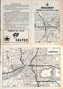 Ballarat Tramway Museum
Map, RACV - Royal Automobile Club of Victoria, "Ballarat including city and district maps", 10/1961
Shows the central part of Ballarat, Ballarat Outlets, streets, principal attractions, Ballarat and district maps and information. Has the tram lines shown dotted, does not run out to Sebastopol or the Lydiard St North terminus. Each map in the bottom left-hand corner has the number "1061", possibly indicating the date. Has notes on the City, points of interest, and an advertisement for Caltex. See item 4929 for a larger version dated 1966. Yields information about the extent of Ballarat in the early 1960's shows the tram lines and other rail lines in the district. Four fold map printed on white paper, titled "Ballarat including city and district maps" - Map No. MAP 15.314 and dated 10-61. Produced by the RACVmap, tranways, ballarat, racv, railways -
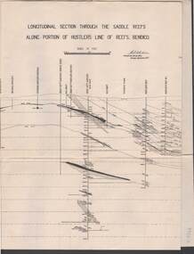 Bendigo Historical Society Inc.
Map - STRUGNELL COLLECTION: HUSTLER'S LINE OF REEF, September 1913
Map, Longitudinal section through the Saddle Reefs along portion of Hustler's Line of Reefs, Bendigo. Plate No. XXX1V(34). Underground Survey Office,Bendigo, September 1913. Geological Society of Victoria.//Signed H.A.Whitelaw. Drawing shows the vertical shaft descending to over 3454 ftUnderground Survey Office, Bendigomap, bendigo, hustler's line of reefs -
Stawell Historical Society Inc
Map, Aerial Photograph of Stawell, c1980
Aerial Photograph of Stawellstawell -
 Bendigo Historical Society Inc.
Map - JACK FLYNN COLLECTION: BET BET, 18/08/1931
Map: Parish of Bet Bet, Counties of Gladstone and Talbot . Parish plan.By Authority H.J. Green Govt, Printer. Photo Lithographed at the Department of Lands and Survey, Melbourne. 18.8.31map, gladstone, parish plan, bet bet, counties of gladstone and talbot. -
 Bayside Gallery - Bayside City Council Art & Heritage Collection
Map, Department of Crown Lands and Survey, Moorabbin, County of Bourke, c. 1918
The cadastral map of the Parish of Moorabbin in Victoria (L.6104) shows parish boundaries and land ownership c. 1918 when Sandringham was a Borough.moorabbin, county of bourke, map, plan, land subdivision, land titles, foreshores, sndringham, hampton, beaumaris, highett, cheltenham, department of lands and survey, land owners, cartographic material, borough of sandringham, brighton -
Merbein District Historical Society
Map, State Rivers & Water Supply Commission-Merbein Urban District n.d, unknown
state rivers and water supply commission, merbein township -
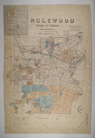 Bendigo Historical Society Inc.
Map - INGLEWOOD, 17/12/1877
Map: Parish of Inglewood, County of Gladstone. Parish plan. Earliest date on map 31/12/75.map, gladstone, parish plan, inglewood -
Bendigo Historical Society Inc.
Map - HUNTLY (PART) RESURVEY, Circa 1877
Map: Huntly [part) resurvey, Parish of Huntly, County of Bendigo. Parish plan ( number 243 in Map Cupboard 1)map, bendigo, parish plan, huntly -
Stawell Historical Society Inc
Map, Northern Grampians Shire, Town of Stawell Planning Scheme, 1981
Amendment No 21 (1981) Scale 1 : 3168 ie 4 Chains = 1 inchmining, gold -
Whitehorse Historical Society Inc.
Map, Whitehorse Road, Blackburn, 1970
Enlarged aerial photograph of area around intersection of Whitehorse and Middleborough Roads, BlackburnEnlarged aerial photograph of area around intersection of Whitehorse and Middleborough Roads, BlackburnEnlarged aerial photograph of area around intersection of Whitehorse and Middleborough Roads, Blackburnwhitehorse road, blackburn, middleborough road, blackburn, maroondah highway, box hill, aerial photographs -
Glenelg Shire Council Cultural Collection
Map, 1885
Significant collection relating to the social history across the shire.Map, Victoria. Skeleton map of Telegraph Circuits and Railways 1885. Scale 16 miles to 1 inch.map, skeleton map, telegraph, railways, 1885, 1880s -
Whitehorse Historical Society Inc.
Map, Pocket guide to walking and wheeling in Whitehorse, 2008
Map showing walks, cycle tracks and off lead areas for dogs in Whitehorse.Map showing walks, cycle tracks and off lead areas for dogs in Whitehorse. Includes walking and cycling groups.Map showing walks, cycle tracks and off lead areas for dogs in Whitehorse. walking trails, bicycle paths, city of whitehorse -
 Bendigo Historical Society Inc.
Map - SANDHURST (PART), No date visible
Map: Parish plan showing the Southwestern corner of Sandhurst to the Municipal boundarymap, bendigo, parish plan, sandhurst -
 Bayside Gallery - Bayside City Council Art & Heritage Collection
Map - print, Melbourne and Metropolitan Board of Works, Interim development order: Brighton, Moorabbin and Sandringham, 1959
The Melbourne and Metropolitan Board of Works (now Melbourne Water) was established in 1891. From that time, as part of their work laying water and sewerage connections, they created detailed plans of houses and other buildings in the Melbourne metropolitan area. In 1956 it acquired powers to construct and maintain highways and bridges, protect and improve the foreshores and create and maintain parks within the metropolitan region. This Interim development order comprises part of the municipalities of Brighton, Moorabbin and Sandringham and was made on 20 October 1959.brighton, moorabbin, sandringham, melbourne and metropolitan board of works, map, town planning, cartographic material, interim development order, bayside -
Canterbury History Group
Map - Victorian Railways, Sheet no.10 , Hawthorn to Canterbury, 1/02/1914 12:00:00 AM
Map of Canterbury Railway Station and its surrounds, includes railway lines and station yards and may houses in nearby streets, February 1914.canterbury, canterbury railway station, canterbury road, maling road, bowling green, canterbury gardens, stationmasters houses, scott crescent, victorian railways -
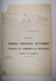 Bendigo Historical Society Inc.
Map - BENDIGO IRRIGATION SETTLEMENT, 20/10/1908
Map: Bendigo Irrigation Settlement, Parishes of Sandhurst and Wellsford, County of Bendigo, Parish planmap, bendigo, irrigation settlement, bendigo irrigation settlement -
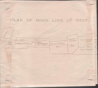 Bendigo Historical Society Inc.
Map - NEW MOON COMPANY, NO LIABILITY - PLAN OF THE MOON LINE 1906
Plan of the Moon Line of Reef 1906. Plan shows the line of reef and the leases with the distance along the reef. The Bendigo - Inglewood railway line is also drawn in. Leases mentioned are: Nth Johnsons, Johnson's Reef,Princess Dagman, Golden Age, Johnson's Reef Extd, Golden Pyke, Constellation, McDuff, Great Northern, Virginia, Specimen Hill, New Hopeful, New Argus, Clarence, North Argus, Moon, South New Moon, New Moon, Suffolk Tribute, North New Moon, New Moon Consolidated, New Moon United, Adelaide New Moon, Bendigo New Moon, The New Moon Northern Blocks, Central New Moon, Rising Moon, Full Moon, The Moon, Gt Extd New Moon, V Rymer.map, bendigo, goldfields, new moon company, no liability, plan of the moon line 1906, a richardson, nth johnsons, johnson's reef, princess dagman, golden age, johnson's reef extd, golden pyke, constellation, mcduff, great northern, virginia, specimen hill, new hopeful, new argus, clarence, north argus, moon, south new moon, new moon, suffolk tribute, north new moon, new moon consolidated, new moon united, adelaide new moon, bendigo new moon, the new moon northern blocks, central new moon, rising moon, full moon, the moon, gt extd new moon, v rymer. bendigo - inglewood railway -
 Whitehorse Historical Society Inc.
Map, Area map of France trench map, 03/02/1918
Coloured trench map of part of France Sheet 62B S.W. Scale 1 : 20,000non-fictionColoured trench map of part of France Sheet 62B S.W. Scale 1 : 20,000maps, world war 1914 - 1918