Showing 2386 items in the category Documentation with item type Map
-
 Bendigo Historical Society Inc.
Map - CITY OF BENDIGO SHEET NO. 4, Circa 1900
Map: City of Bendigo sheet No. 4. Parish plan ( number 218 in Map Cupboard 1)map, bendigo, parish plan, bendigo -
Glenelg Shire Council Cultural Collection
Map, 1885
Significant collection relating to the social history across the shire.Map, Victoria. Skeleton map of Telegraph Circuits and Railways 1885. Scale 16 miles to 1 inch.map, skeleton map, telegraph, railways, 1885, 1880s -
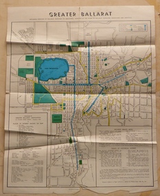 Ballarat Tramway Museum
Map, Greater Ballarat Association and George Netherway, "Map of Ballarat", c1950
Yields information about Greater Ballarat, including trams, buses, locations and streets. Has a strong association with George Netherway.Four colour map of Ballarat, showing streets, places of interest, Parks, tram routes, bus routes, railway lines, prepared by G. C. Netherway, Greater Ballarat Association. Shows suburbs names, location of places of interest, some development north of Howitt St, in Wendouree. Map is part diagrammatic and is not entirely to scale. Includes the Lake Wendouree Rowing course On rear is a road map of the Ballarat area, lists of statistics, beauty spots, look outs, art and culture, points of historical interest, industrial products and recreation. Printed by Waller & Chester on paper produced by Ballarat Paper Mills Pty Ltd. See Reg item 2074 for photographic image of this version of the map. See Reg Item 2776 for another version of this map. Contained originally within Reg Item 5507 at the back of the binder. For items see btm5507 loose items list.pdf John Whiting in an email of 17-9-2021 noted: The rowing course along Lake Wendouree is noted, so perhaps this map is post 1956? The Mt Pleasant tram line is shown to terminate at Morton St, not Cobden St (which of course is incorrect) Someone's come along and drawn in black ink the branch of the View Point tram line!trams, tramways, ballarat, tram routes, bus routes, map, lists -
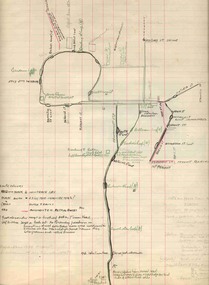 Ballarat Tramway Museum
Map, H.P. James, Ballarat tramway system, 1939
Hand drawn map contained within Reg. Item 2488, page 61 of the Ballarat Tramway system. Note does not show the Drummond St. North line. Shows the loops, horse tram loops, depots, ESCo bus routes, and notes on horse tram loops. Prepared by H.P. James Scan btm2515i2 and 2515i3 show the hand written notes in light pencil. Note Item Not formally Numbered.trams, tramways, map, depot, esco, horse trams, bus routes, ballarat -
Bendigo Historical Society Inc.
Map - LYELL, 4/06/1873
Map: Lyell. Parish plan (number 278 in map cupboard 1)map, bendigo, parish plan, lyell -
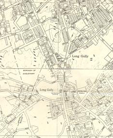
 Bendigo Historical Society Inc.
Map - LONG GULLY HISTORY GROUP COLLECTION: MAP OF LONG GULLY AREA
BHS CollectionTwo copies of a map, printed on yellow paper, of the Long Gully Area. It shows Eaglehawk Road from Barnard Street to a little past William Street.bendigo, history, long gully history group, the long gully history group - map of long gully area, victorian water supply reserve, borough of eaglehawk -
Bendigo Historical Society Inc.
Map - PANNOOMILLOO : COUNTY OF BENDIGO, 1957
Map. Pannoomilloo, County of Bendigo, Pannoobamawm, Milloo, Warragamba, Diggorra, Property Allotments. Drawn and Reproduced at the Department of Lands and Survey,1957. Price 2/-. (number 412 in Map Cupboard 1 ).W.M. Houston, Government Printer, Melbourne.bendigo, hospital -
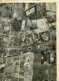 Whitehorse Historical Society Inc.
Map, Photo-map Ringwood A4A, 1945
Aerial photo covering approximately from Box Hill to Mitcham (West to East) and Springfield Road to Hawthorn Road (North to south).Aerial photo covering approximately from Box Hill to Mitcham (West to East) and Springfield Road to Hawthorn Road (North to south). Names of main roads inscribed.Aerial photo covering approximately from Box Hill to Mitcham (West to East) and Springfield Road to Hawthorn Road (North to south).aerial photographs, box hill, blackburn, nunawading, forest hill, mitcham -
Stawell Historical Society Inc
Map, Bellellen, County of Borung, 1952
Bellellen, County of Borungstawell -
 Bendigo Historical Society Inc.
Map - LONG GULLY HISTORY GROUP COLLECTION: MAP OF LONG GULLY AREA
BHS CollectionMap of Long Gully area printed on yellow paper. Map shows Eaglehawk Road from Don Street to Weatherall Street, then Mt Korong Road to Dowding Street. Some contour lines on the map.bendigo, history, long gully history group, the long gully history group - map of long gully area, borough of eaglehawk -
Lakes Entrance Historical Society
Map - Lakes Entrance Toorloo Arm
Map shows Kalimna, Lakes Entrance, Lake Tyers, Sawmilling Co. Murray 1892-96, Casey Creek, Princes Highway, Palmer (tram only)1925-29forest, townships, waterways, tramline -
National Vietnam Veterans Museum (NVVM)
Map - Maps, topographical
Standard issue items as used by Australian servicemen during the war in Vietnam.Set of 18 declassified US produced maps of various regions within South Vietnam. 1. Bien Hoa, Sheet 6330, Edition 4 2. Bien Hoa, Sheet 6330, Edition 4 3. Nhon Trach, Sheet 6330, Edition 3 4. Nhon Trach, Sheet 6330, Edition 3 5. Can Guioc, Sheet 6330, Edition 3 6. Can Guioc, Sheet 6330, Edition 3 7.Ho Chi Minh city, Sheet 6330, Edition 5 8.Ho Chi Minh city, Sheet 6330, Edition 5 9. Tan Uyen, Sheet 6331, Edition 3 10. Ben Cat, Sheet 6331, Edition 2 11. Phuoc Vinh, Sheet 6331, Edition 3 12. Xom Ruong, Sheet 6331, Edition 3 13. Cho Phuoc Hai, Sheet 6429, Edition 4 14. Xa Vung Tau, Sheet 6429, Edition 3 15. Xa Cam My, Sheet 6430, Edition 2 16.Xuyen Moc, Sheet 6430, Edition 3 17. Xa Binh Ba, Sheet 6430, Edition 2 18. Xa Xuan Loc, Sheet 6430, Edition 2 map, vietnam map, topographical, bien hoa, nhon trach, can guioc, tan uyen, ho chi minh city, phuoc vinh, ben cat, xom ruong, cho phuoc hai, xa cam my, xa binh ba, xa xuan loc, xuyen moc, xa vung tau, binh ba, vung tau -
Whitehorse Historical Society Inc.
Map, Highbury Road, c1970
Enlarged aerial photo of Highbury Park area.Enlarged aerial photo of Highbury Park area.Enlarged aerial photo of Highbury Park area.highbury road, burwood east, gareth drive, burwood east, blackburn road, burwood east, bennett avenue, burwood east, rae street, burwood east, joy street, burwood east, folkestone road, burwood east, burwood east primary school no. 454, aerial photographs -
 Greensborough Historical Society
Map, Greensborough c 1980s, 1980s
Map of Greensborough and surrounds showing bus routes servicing Eltham College.Map of Greensborough and surrounds, black print with colour markings."Bundoora Retirement Village" marked in red pen at E20greensborough - maps, eltham college, bus routes, public transport -
Bendigo Historical Society Inc.
Map - BOROUGH OF EAGLEHAWK, 30/11/1931
Map: Borough of Eagle hawk, Parish of Nerring. Parish plan with coloured areas ( number 185 in Map Cupboard 1)map, bendigo, parish plan, borough of eaglehawk, parish of nerring -
Bendigo Historical Society Inc.
Map - RAVENSWOOD, COUNTIES OF BENDIGO & TALBOT, 12-12-22
Map, Ravenswood, Counties of Bendigo & Talbot, Shelbourne, Walmer, Harcourt, Sutton Grange, Mandurang, Lockwood.By Authority A.J.Mullett, Govt. Printer, Melbourne. Photo-Lithographed at the Dept. of Lands and Survey, Melbourne by W.J.Butson 12-12-22, Price1/-. (number 87 in map cupboard 1)A.J.Mullett. Govt. Printer, Melbourne.map, bendigo, ravenswood -
Whitehorse Historical Society Inc.
Map, Burwood Road, Box Hill City, 1952
Country Roads Board survey of Burwood Road, Burwood between Central Avenue and Elgar Road. Includes details of fencing, nature of buildings. With penciled additions to 1957.Country Roads Board survey of Burwood Road, Burwood between Central Avenue and Elgar Road. Includes details of fencing, nature of buildings. With penciled additions to 1957.Country Roads Board survey of Burwood Road, Burwood between Central Avenue and Elgar Road. Includes details of fencing, nature of buildings. With penciled additions to 1957.maps, burwood road, burwood, parer street, elgar road, cromwell street, ireland street, central avenue burwood, scott grove, somers street, gilmour street, evans street, edwards street, mills road -
Bendigo Historical Society Inc.
Map - HEATHCOTE, 11/04/1935
Map: Parish of Heathcote, County of Dalhousie. Parish plan (number 320 in map cupboard 1)map, dalhousie, parish plan, heathcote -
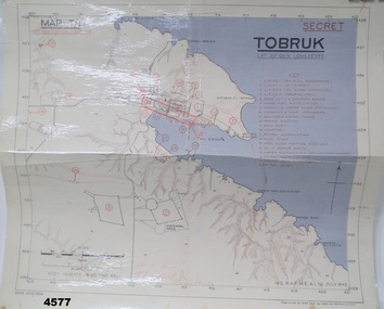 Bendigo Military Museum
Map - MAP of TOBRUK HARBOUR, 48 Survey Coy S.A.E.C, C.1942
Item in the Doug Dean 2nd AIF collection, refer cat No 4575PMap, laminated, “MAP T/1 SECRET TOBRUK”, shows Tobruk area and harbour, shows creeks, gullies, there are 20 marked installations in red, a rectangular section has been hand drawn on marked “E” & “F”,.At bottom RH corner, “HQ, RAF, ME, A1, 16 JULY 1942”tobruk, maps, ww2 -
 Bayside Gallery - Bayside City Council Art & Heritage Collection
Map, Department of Crown Lands and Survey, Moorabbin, County of Bourke, c. 1918
The cadastral map of the Parish of Moorabbin in Victoria (L.6104) shows parish boundaries and land ownership c. 1918 when Sandringham was a Borough.moorabbin, county of bourke, map, plan, land subdivision, land titles, foreshores, sndringham, hampton, beaumaris, highett, cheltenham, department of lands and survey, land owners, cartographic material, borough of sandringham, brighton -
Clunes Museum
Map
Photocopy of sections of Clunes gold mines, South Clunes United Co. 770 Feet, South No.4 Shaft, looking SouthNilmap of clunes mine, south clunes united co., no.4 shaft -
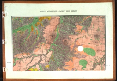 Federation University Historical Collection
Map, Clunes, Mt Greenock, and Talbot Gold Fields, 1883, 1883
A geological plan of the Clunes, Mt Greenock, and Talbot Gold Fields in two parts. .1) This section of the map includes Talbot, Talbot water supply race, Mt Glasgow, Little Green Hill, Middle Hill, Mt Cameron, Ballarat Hill, Bakery Hill, Goodwoman Hill, Scandanavian Lead, Eglinton Swamp, McCallum's Creek, Tullaroop Creek, Dunach, Maryborough Railway, Middle Creek and includes many mines such as Rip Van Winkel, Union Extended, South Greenock, Nicholl's Freehold. .2) This section of the map includes McCallums, Clunes, Green Hill, Mt Beckworth, Mt Gap, Maryborough Reservoir, and includes mines such as Lothair, Bute, Clyde, Clunes Consols, London and Australian, Oriental,clunes, talbot, water supply, railway, geology -
Bendigo Historical Society Inc.
Map - TARNAGULLA : COUNTY OF BENDIGO, 1959
Map. Tarnagulla, County of Bendigo, County of Gladstone, Inglewood, Glenalbyn, Kingower, Moliagul, Painswick, Waanyarra, Laanecoorie, Woodstock, Derby, Loddon River, Dunolly to Inglewood Railway, Laurie Railway Station, Township of Tarnagulla, Tarnagulla Rifle Range, Township of Llanelly, Arnold Railway Station, Bullabul Creek, Kangderaar Creek, Township of Newbridge. By authority A.C. Brooks, Government Printer, Melbourne. Drawn and reproduced at the Department of Lands and Survey, Melbourne, 1959. (number 117 in map cupboard 1)A.C. Brooks, Government Printer, Melbourne.map, bendigo, tarnagulla -
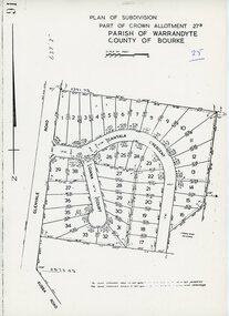 Ringwood and District Historical Society
Map - Plan of Subdivision, Part of Crown Allotment 27B Parish of Warrandyte County of Bourke (undated, circa 1970)
Photocopied subdivision map of 38 residential allotments in Glenvale Road, Cantala Crescent, and Giana Court, north of Kubba Road, Ringwood. -
Bendigo Historical Society Inc.
Map - MARONG, June 1953
Map: Marong, County of Bendigo. Parish plan ( number 164 in Map Cupboard 1)map, bendigo, parish plan, marong, county of bendigo -
Bendigo Historical Society Inc.
Map - CAMPBELL COLLECTION: BENDIGO AND DISTRICT MAPS, 10-5-29
Map. Mandurang, Scale 20 chains to an inch. Total area 5746 acres. Kennington, Township of Mandurang. To accompany my report of 10-5-29 R. Marshall, Forest assessor. Drawn by I.M.K. (number 399 in map cupboard 1)I.M.K.map, bendigo, allotments -
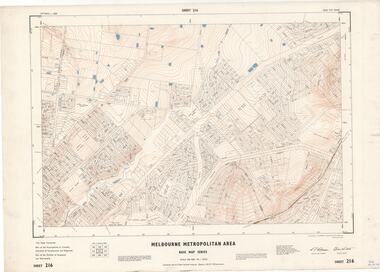 Ringwood and District Historical Society
Map - Melbourne Metropolitan Area Base Map Series, Sheet 216 - Ringwood area, 1967
Map prepared by Dept of Lands and Survey and MMBW from State Aerial Survey June 1957 and Cadastral Survey information July 1967. This sheet comprises parts of Municipalities of Croydon, Doncaster & Templestowe, and Ringwood, and Parishes of Ringwood and Warrandyte.Scale: 400 feet to 1 inch. Contours at 5 feet vertical interval. By Authority: A.C. Brooks, Commonwealth Printer, Melbourne. -
![Map, [Coornmill land area available for leasing for grazing, Parish of Coornmill]. Circa 1904](/media/collectors/5e461d8021ea67224c82f2a1/items/677cde147f2053f3e5d277c3/item-media/677cdeea7f2053f3e5d27bb4/item-fit-380x285.jpg) Bacchus Marsh & District Historical Society
Bacchus Marsh & District Historical SocietyMap, [Coornmill land area available for leasing for grazing, Parish of Coornmill]. Circa 1904
This map shows an area of land north of Bacchus Marsh in the Larderderg State Park area known as the Parish of Coornmill.The map indicates an area of land which was to be made available by public tender for grazing leaseholders. The plan to do this was discussed in the Bacchus Marsh Express newspaper on the 16 July, 1904, page 2, column 7. The area reserved for grazing leases is identified by red lines on the map. The Express described the area available for grazing was 12,000 acres.A single page paper map showing an area of land in the Parish of Corrnmill to be made available for grazing leases. A photo lithographed Lands Department Map. No scale indicated. The map is pasted into a bound volume containing 76 maps or plans in total. High resolution digital image stored on BMDHS computer network. coornmill parish maps, lerderderg state park maps, agriculture bacchus marsh area -
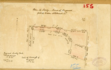 Ringwood and District Historical Society
Map, Plan of Survey, Parish of Ringwood - Part of Crown Allotment 31A - 1950
Hand drawn and labelled copy of map with survey measurements of allotment on Isobel Avenue (Isabel Avenue?), Ringwood East. Raymond Dudley Steele Licensed Surveyor 10-8-50, signed 6-9-50, Seal of Borough of Ringwood 26-9-50. Rubber stamp - Dugdale, Simmons & Stevens, Solicitors, Peacock House, 486 Bourke Street Melbourne. Typewritten heading on backing paper - Capt. M.H. Moyes - Correspondence Supplementary to Statements. -
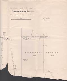 Bendigo Historical Society Inc.
Map - STRUGNELL COLLECTION: UNDERGROUND SURVEY OF MINES, BENDIGO, 20-3-01
Map, Underground Survey of Mines, Bendigo.Shenandoah Co., New Chum Line,H.S.Whitelawmap, bendigo, shenandoah co.