Showing 2195 items
matching documentation
-
 Bendigo Historical Society Inc.
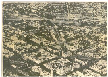
Map - BENDIGO MAP AERIAL VIEW, 1890s
Map of Bendigo. Aerial View of Bendigo. This aerial photograph was taken specially to mark the pccasion of the United Country party conference of 1936. Issued with the complements of 'The Argus' April 1936.photograph, aerial, bendigo -
 Bendigo Historical Society Inc.
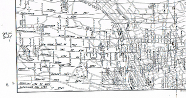
Map - LONG GULLY HISTORY GROUP COLLECTION: MAP OF REEFS AND MINES
BHS CollectionTwo pages with lines of reef and mines from Spring Gully Reservoir to north of the Eaglehawk Railway Station. Shown on the map are the lines of reef, the Thistle, Carshalton, Napoleon, British & Foreign, Nell Gwynne, New Chum, Sheepshead, Deborah, Garden Gully, Paddy's Gully, Derby, Miller's, Hustlers, Lightning Hill, Myers Flat, Lancashire, Cook's, Maiden Gully, Johnson's and Millers. Also shown are the Golden Square, Bendigo and Eaglehawk Railway Stations as well as the hills.bendigo, history, long gully history group, the long gully history group - map of reefs and mines, spring gully reservoir, thistle, carshalton, napoleon, british & foreign, nell gwynne, new chum, sheepshead, deborah, garden gully, paddy's gully, derby, miller's, hustlers, lightning hill, myers flat, lancashire, cook's, maiden gully, johnson's, millers, golden square railway station, bendigo railway station, eaglehawk railway station -
 Melbourne Tram Museum
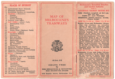
Map, Melbourne & Metropolitan Tramways Board (MMTB), "Map of Melbourne Tramways", 1934
Map booklet consists of three pages of bus and tram round trips, 3 center pages for a map of electric and cable trams, route numbers, and points of interest. Has 4 pages giving an index to routes and first and last trams to and from the City. Shows points where suburban routes are intersected by City routes. One page of places of interest. Dated 1934/35.Demonstrates methods of giving information to visitors to Melbourne and yields information about tram services at the time in Melbourne.Map - 2 octavo cards stapled and folded into 12 pages. All printing is in black with red headings and highlights except for the map which is in four colours.tramways, trams, mmtb, map, timetables, tourist trips -
 Montmorency–Eltham RSL Sub Branch
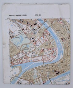
Map, Baghdad
Prepared and published by the National Imagery and Mapping Agency Copyright 2003 by the United States GovernmentPaper, coloured The map is of Baghdad Iraq city Graphic 1:25,000. WGS 84 Edition 11- NIMA Series K941 Sheet 4 Map information as of 2001map -
 Stawell Historical Society Inc
Map, Ledcourt, County of Borung, Shire of Stawell, 1957
Ledcourt, County of Borung, Shire of Stawellstawell -
Bendigo Historical Society Inc.
Map - HARCOURT : COUNTY OF BENDIGO, December 1951
Map. Harcourt, County of Bendigo, County of Talbot, Town of Harcourt, Walmer, Sutton Grange, Ravenswood, Victorian Water Supply Reservoir, in connection with Barkers Creek Reservoir, Barkers Creek, Calder Highway, Northern Railway, Axe Creek. By authority J.J. Gourley, Government Printer, Melbourne. Drawn and reproduced at the Department of Lands and Survey, Melbourne. December 1951. Price 5/- per sheet. (number 100 in map cupboard 1)J.J. Gourley, Government Printer, Melbourne.map, bendigo, harcourt -
Port Melbourne Historical & Preservation Society
Map - Port Melbourne, Department of Lands and Survey, 20 Sep 1932
Dept. of Lands and Survey Map Sheet 5 Port Melbourne, Parish of South Melbourne.Annotated re MHT precincts on foreshore:Plan sketches re boat harbourtown planning, sandridge lagoon, melbourne harbor trust - port of melbourne authority, transport - railways -
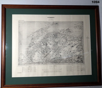 Bendigo Military Museum
Map - MAP GALLIPOLI, FRAMED
Brown, wooden frame with glass front, white cardboard backing, map mounted with green border. Map of Gallipoli area in black & light grey with white border. A detailed map of Turkey area around Dardanelles with references & scale charts at bottom. Reprinted for the Department of Defence, Commonwealth of Australia, May 1915.Front Top Centre: Turkey, Gallipoli. Rear: Bethany Gallery stamp.documents - maps, military history, gallipoli -
 Federation University Historical Collection
Map - Geological Survey, J. Phillips, Geological Survey of Victoria - Ballarat, 1857, 10/1858
Geological map of the Ballarat District featuring four colours.ballarat, geological, geology, geological plan, main road, camp, golden point, pennyweight hill, clayton hill, ballaarat cemetery, bakery hill, specimen hill, soldiers hill, nightingale lead, native youth black hill flat, white flat, mining, mines, eureka lead, old post office hill -
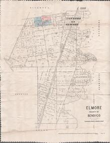 Bendigo Historical Society Inc.
Map - MAP. ELMORE COUNTY OF BENDIGO, 1918
Map. Elmore County of Bendigo. Diggorra. Burnewang. Ryunnymead. Egerton Photo-Lithographed at the Department of lands and Survey Melbourne, by W. J. Button. 4.7.18 -
Whitehorse Historical Society Inc.
Map, Aspinall's old abattoirs, Box Hill, 1937
Hand drawn plan of subdivision of old abattoirs site, Woodhouse Grove, Box Hill North.Hand drawn plan of subdivision of old abattoirs site, Woodhouse Grove, Box Hill North.Hand drawn plan of subdivision of old abattoirs site, Woodhouse Grove, Box Hill North.land subdivision, aspinall's estate, woodhouse grove, box hill north, aspinall road, box hill north, abattoirs -
Whitehorse Historical Society Inc.
Map, Applied for the Roman Catholic Church, 1848
Photocopy of manuscript map inscribed 'Reserve 40 Parish of Nunawading'.Photocopy of manuscript map inscribed 'Reserve 40 Parish of Nunawading'. Streets not named. Note on verso: Site reserved for Roman Catholic Church in Nunawading c1848 (Cr Riversdale and Warrigal Roads)Photocopy of manuscript map inscribed 'Reserve 40 Parish of Nunawading'. churches, catholic church, riversdale road, surrey hills, warrigal road, surrey hills -
 Greensborough Historical Society
Map - Map (Copy), C. Hodgkinson, District Surveyor et al, Parish of Yan Yean 1856: Village site during construction of the Yan Yean Reservoir, 1978
Copy of map part Sec. 13, Parish of Yan Yean 1856, Map 3, Village site... Scale: 8 chains to 1 inch. Drawn by C. Hodgkinson, District Surveyor, redrawn by A. R. Blair 1978. 1 p. photocopy of map. yan yean reservoir, yan yean -
Glen Eira Historical Society
Map - a'Beckett Street, 11, East St Kilda
Print of a Google map of 11 a’Becket Street, East St Kilda downloaded & printed on November 26, 2010 by Sud Abbas (role unknown). Detail shows that the address is now a car parka’beckett street, east st kilda, car parks, streetscapes, aerial photographs -
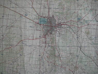
 Bendigo Historical Society Inc.
Map - BENDIGO GOLDFIELD MAP
Two not very clear copies of the Bendigo Goldfield Map. Streets, Railway Line, Lines of Reefs and mines are shown. Dept. of Mines, Victoria printed on the map. Shows reefs from Bird's Line of Reefs to Lightning Hill Line of Reef.map, bendigo, goldfields, bendigo goldfield map, lines of reefs, dept. of mines victoria -
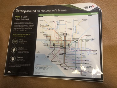 Melbourne Tram Museum
Map, Orajet, "Melbourne tram network", "Getting around on Melbourne's trams", Jan. 2015
Large plastic sheet, with an adhesive back and cover protective sheet - titled "Melbourne tram network" and "Getting around on Melbourne's trams" with PTV, Metro, Yarra Trams logos, shows fare zones, ticketing, free tram zone and information about Myki and how to use it.. Published 2015. Printed by Orajet, digital printing media. Has rounded corners along the top edge and square corners in both bottom corners. Two copies held.On rear in felt pen "Camira Orange Fine"trams, tramways, yarra trams, ptv, maps, free tram, melbourne, myki -
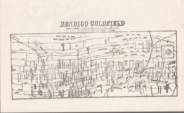
Bendigo Historical Society Inc.
Map - SANDHURST GOLDFIELDS MAP, 1873
BHS CollectionTopographical map of the Sandhurst Goldfilelds. Surveyed by R Brough. May 1873 Coloured map.bendigo, gold mining, sandhurst goldfields -
Bendigo Historical Society Inc.
Map - PLAN OF VICTORIA HILL AREA, 1971
BHS CollectionBendigo Historical Society feature Plan of the Victoria Hill area. Printed on Paper and laminated. B & W. Compiled by AHG Survey Regiment.CMF Increment May 1971bendigo, gold mining, victoria hill -
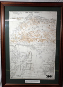 Bendigo Military Museum
Map - MAP, NEW GUINEA FRAMED, 1941 onwards
Map of Western section of New Guinea. Black print on white background with mountain ridges in tan. Mounted with green border & brown wooden frame, glass front & white cardboard backing with wire hanging strap on back. Inset LHS bottom: A: Aroe Island B: KIA Island C: Taniimba IslandPrinted in black at top centre: “NEW GUINEA WESTERN’ Printed on border under map: “These escape maps were carried in the zip pockets of life jackets by fighter pilots in WW2. This map was presented to A.S.R. on the 12/7/79 by Councillor Ian McKenzie, Mayor of Eaglehawk, who served as a fighter pilot in 78th SQN in S.W. Pacific area during 1943-44.”map, new guinea, western, raaf -
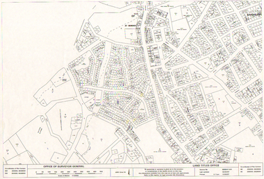 Bendigo Historical Society Inc.
Map - LONG GULLY HISTORY GROUP COLLECTION: LONG GULLY AREA
Copy of a map showing streets and allotments in the Long Gully area, last updated 30/05/97, printed 19/06/97. Made by the Land Titles Office. Some street names, reserves and allotment numbers are printed on the map.bendigo, history, long gully history group, the long gully history group - long gully area, land titles office, office of surveyor general, city of bendigo, shire of marong, state electricity commission -
Bendigo Historical Society Inc.
Map - SANDHURST (PART), Circa 1880's
Map: Parish plan sowing an area along Specimen Hill Rd. ( number 211 in Map Cupboard 1)map, bendigo, parish plan, specimen hill rd. sandhurst , bendigo -
Whitehorse Historical Society Inc.
Map - WW1 Trench map, Belgium collected by C H Honybun, Belgium WW1 map Edition 3, Nov 1917
WW1 map of Belgium Edition 3 Sheet 28 S.W. and S.E. Trenches in rednon-fictionWW1 map of Belgium Edition 3 Sheet 28 S.W. and S.E. Trenches in redworld war 1914 - 1918, maps -
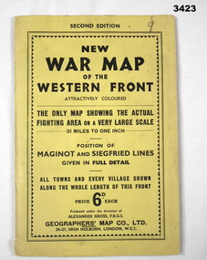 Bendigo Military Museum
Map - WAR MAP WESTERN FRONT, Geographer's Map Co Ltd, c.WWII
Folded map fixed into yellow cardboard folder with black printing. Map covers battle areas late in WWII of Maginot Line & Siegfried Line from Metz, France to Karlsruhe, Germany.On cover in black print: “Second Edition. New War Map of the Western Front”map, seigfreid, maginot -
 Bacchus Marsh & District Historical Society
Map, Trentham Parish Map 1905 Copy 1
A single page paper map showing the map for the Parish of Trentham in the Counties of Dalhousie and Bourke. A cadastral map showing parish boundaries and land ownership. The map is pasted into a bound volume containing 76 maps or plans in total. High resolution digital image stored on BMDHS computer network. Photo-lithographed at the Department of Lands and Survey, Melbourne by T.F. McGauran 22.3.05 trentham parish maps, trentham parish plan, bacchus marsh region parish plans -
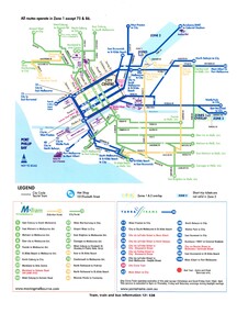 Melbourne Tram Museum
Map, VicTrip, Melbourne tram network - Yarra and M>Tram, 2000
Map - Colour print - of Melbourne's tram network, shows the lines operated by M>Tram or Yarra Trams, route numbers, ticket zones, zone overlaps and contact websites. - used in Fares and Travel Guide - 2000 and 2001 Map - see Reg Item 2508.trams, tramways, connex, map, melbourne, tramways, m>tram, yarra trams -
 Federation University Historical Collection
Map, Ballarat, 1936, 06/1936
Map of Ballarat and surrounds, including Lake Learmonth, Snake Valley, Linton, Newton, Durham Lead, Sebastopol, Lake Wendouree, Winter Swamo. It was surveyed in 1933.ballarat, map -
Stawell Historical Society Inc
Map, T.F. McGauran, Winjallock County of Kara Kara, 1900
Noth of Navarre and BarkleyA2 Map0f Parish of Kara Kara.Photo Lithographed and the department of Lands & Survey, Melbourne by T.F. McCauran 22.10.00survey -
 Bendigo Historical Society Inc.
Map - STRUGNELL COLLECTION: HUSTLER'S LINE OF REEFS, BENDIGO, September 1913
Map, Hustler's Line of Reef, Hustler's Royal Reserve No. 2, Park Shaft, Bendigo, Plate No. 1X (9). Bulletin No 33 Signed H.A.Whitelaw Underground survey Office Bendigo September 1913 Drawing shows mine shaft to over 1099 feet deep and appears to show samples of connecting horizontal shafts with their respective mineral contentsUnderground Survey Office, Bendigo.map, bendigo, hustler's royal reserve no. 2 mine* -
 Bendigo Historical Society Inc.
Map - LONG GULLY HISTORY GROUP COLLECTION: LONG GULLY
Copy of a map of Long Gully area with some street names, size of allotments, number, measurements, date and names.bendigo, history, long gully history group, the long gully history group - long gully, housing commission, housing act 1958, gazette -
Bendigo Historical Society Inc.
Map - CAMPBELL COLLECTION: BENDIGO AND DISTRICT MAPS, 16-4-29
Map. Kennington, Parishes of Sandhurst, Mandurang and Strathfieldsaye. Scale 20 chains to 1 inch. Total area 2918 acres. Prepared in W.P.B. from A. and C.L. Plans by W.J.Galbraith, 16-4-29. (number 394 in map cupboard 1)W.J.Galbraithmap, bendigo, allotments