Showing 2250 items in the category Documentation with item type Map
-
 Whitehorse Historical Society Inc.
Map, Springvale Road, 1975
Aerial photograph of area around cnr. of Springvale Road and Burwood Highway, south past Highbury Road and East in Vermont South.Aerial photograph of area around cnr. of Springvale Road and Burwood Highway, south past Highbury Road and East in Vermont South.Aerial photograph of area around cnr. of Springvale Road and Burwood Highway, south past Highbury Road and East in Vermont South.aerial photographs, vermont south, highbury road, burwood east, burwood highway, burwood east, burwood east -
Glenelg Shire Council Cultural Collection
Map - Map - RACV Road Map, 1970s
RACV road map, Warrnambool District, Port Fairy to Lorne. Large coloured map of Warrnambool District. Small maps of Apollo Bay, Colac, Camperdown, Tower Hill and Warrnambool. When folded, black and white photo on cover of 12 Apostlesracv, road touring, road map, victoria -
Whitehorse Historical Society Inc.
Map, Dandenong Ranges Area, 1956
Sheet 1. Parts of Parishes: Nunawading, Warrandyte and Ringwood. Scale: 10 chains : 1 inch. Contour intervals marked and locations of buildings.Sheet 1. Parts of Parishes: Nunawading, Warrandyte and Ringwood. Scale: 10 chains : 1 inch. Contour intervals marked and locations of buildings. Compiled from aerial photographs and cadastral survey information.Sheet 1. Parts of Parishes: Nunawading, Warrandyte and Ringwood. Scale: 10 chains : 1 inch. Contour intervals marked and locations of buildings. maps, ringwood, mitcham, warrandyte -
Whitehorse Historical Society Inc.
Map, Eastern Freeway Extension, 2002
Extension of Eastern Freeway: Plan of Deep Creek Road paths, drainage and alignment plan.Extension of Eastern Freeway: Plan of Deep Creek Road paths, drainage and alignment plan.Extension of Eastern Freeway: Plan of Deep Creek Road paths, drainage and alignment plan.deep creek road, mitcham, eastern freeway extension, eastlink -
 Bendigo Historical Society Inc.
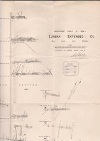
Map - STRUGNELL COLLECTION: UNDERGROUND SURVEY OF MINES, BENDIGO, 29-4-01
Map, Underground Survey of Mines, Bendigo.Eureka Extended Co., New Chum Line. Signed H.A.Whitelaw 29.4.01 Drawing shows mine shaft from 1871 feet to over 3030 feet deep and appears to show samples of connecting horizontal shafts with their respective mineral contents.A>S>Whitelawmap, bendigo, eureka extended co. -
 Port Melbourne Historical & Preservation Society
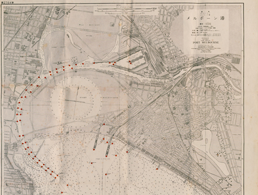
Map - Large map of Port Melbourne with Japanese annotation, British Chart, Port Melbourne, c 1937
Jim Sinclair was born in Cruickshank Street, Port Melbourne in 1924. During World War II Jim found this Japanese map in a network of caves near Rabaul, Papua New Guinea. He remembers '"The Japanese had linked just about every hill with a tunnel. Concreted. Most of them were packed with stuff. I used to wander through - being very careful too, mind you!. You didn't want yourself to get blown up. I found these maps. I thought that looks familiar! It's in English with Japanese stuff on it too."A large 1937 British map of Port Melbourne with Japanese printed annotations with strategic infrastructure marked. Used during World War II. Stamp on back explains age in Japanese. war - world war ii, port of melbourne, jim sinclair, japanese -
 Whitehorse Historical Society Inc.
Map - Nunawading scaled Map, Nunawading, 1864
Parish plan of Nunawading, Lands Department, 1864, showing names of first purchasers of land. Copy also at NP215.parish of nunawading, land settlement, maps -
Bendigo Historical Society Inc.
Map - CAMPBELL COLLECTION: BENDIGO AND DISTRICT MAPS, 22-3-29
Map. Marong, Parishes of Marong, Lockwood and Mandurang, Scale 20 chains to 1 inch, Total area 5106 acres. Crusoe Reservoir & Viaduct and water race. Compiled in W.P.B. fro Field Survey and Parish Plans. B.W.L.22-3-29 (number 389 in map cupboard 1)B.W.L.map, bendigo, allotments -
 Bendigo Historical Society Inc.
Map - JACK FLYNN COLLECTION: TARNAGULLA, 13/05/1922
Map: Parish of Tarnagulla . This Item is in very poor condition.By Authority, A. J. Mullen, Government Printer, Melbourne. Lithographed at the Department of Lands and Survey, Melbourne by W. J. Butsonmap, gladstone, parish plan, tarnagulla -
Bendigo Historical Society Inc.
Map - RAVENSWOOD, April 6th 1872
Map: Township of Ravenswood. Parish plan, has a 1913 calendar as a backing (number 266 in map cupboard 1)map, bendigo, township, ravenswood -
Bendigo Historical Society Inc.
Map - DIGGORA, 7/03/1892
Map: Parish of Diggora, County of Bendigo. Parish plan (number 341 in map cupboard 1)map, bendigo, parish plan, diggora -
Bendigo Historical Society Inc.
Map - EGERTON, 22/03/1892
Map: Parish of Egerton, County of Bendigo. Parish plan (number 343 in map cupboard 1)map, bendigo, parish plan, egerton -
Stawell Historical Society Inc
Map, Victorian Topographic Map Illawarra
Topographic Map 1:25000 Coloured 1978Illawarra 7423-4-1mapping -
Bendigo Historical Society Inc.
Map - PANNOOBAMAWM, 6/11/1882
Map: Parish of Pannoobamawm, County of Bendigo, Parish plan (number 314 in map cupboard 1)map, bendigo, parish plan, pannoobamawm -
 Robin Boyd Foundation
Map, Printemps, Find Your Way in Paris (2 copies)
walsh st library -
 Ringwood and District Historical Society
Map, Subdivision Plan of residential allotments in Caroline Street, Thomas Street, Emerald Street and Ford Street, Ringwood, Victoria - (Undated, circa 1930)
Map of residential allotments on blue cardboard backing.Handwritten title reference notation LP13641. -
 Bendigo Historical Society Inc.
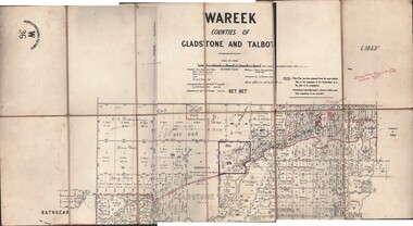
Map - JACK FLYNN COLLECTION: WAREEK, Examined 1918
Map: L.1053. Parish of Wareek, Counties of Gladstone and Talbot. Parish plan. Looks like half of the sheet is missing.Second Issue. Examined by S.F. Green. July 1918. William J. Swan, Draughtsman, August 1884. Photo-Lithographic Fac-Simile, W 36.map, gladstone, parish plan, wareek -
Whitehorse Historical Society Inc.
Map, Shire of Blackburn and Mitcham, 10/10/1939 update
Map of Shire of Blackburn and Mitcham showing Departmental ball hydrants and departmental pillar ball hydrants.Map of Shire of Blackburn and Mitcham showing Departmental ball hydrants and departmental pillar ball hydrants. Scale 8 chains to 1 inch.Map of Shire of Blackburn and Mitcham showing Departmental ball hydrants and departmental pillar ball hydrants.shire of blackburn and mitcham, fire hydrants, blackburn, blackburn north, blackburn south, burwood east, forest hill, mitcham, nunawading, vermont, vermont south -
Stawell Historical Society Inc
Map, Topographic Map Stawell South
Topographic Map 1:25000 Coloured 1990Stawell South 7423-1-Smapping -
Federation University Historical Collection
Map - Framed image, Public Record Office Victoria, Eureka Treason Trial Map (printed copy), 1855
The persecution produced the original of this map as an exhibit for the Treason Trials of thirteen of the Eureka Stockade in Melbourne in 1855. Witnesses at the time accepted that the map showed the location of the stockade at Ballarat and the route taken by the military and police when the stockade was attacked on 03 December 1854. The original of this work is held by the Public Record Office Victoria.Printed copy of the plan used at the Eureka Treason Trials in 1855.eureka stockade, treason trial map, ballarat, lydiard street north, camp street, paroompi, yarrowee creek -
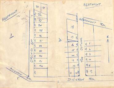 Ringwood and District Historical Society
Map - Subdivision Plans, Residential allotments in Orchid Street and The Outlook, between Heathmont Road and Dickason Road, Heathmont, Victoria - (Undated - circa 1940)
Two adjoing hand-drawn maps on light cardboard backing. -
Stawell Historical Society Inc
Map, Water Supply, Wimmera Mallee Water
Water Supply, Wimmera Mallee Waterstawell, water -
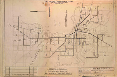 Ballarat Tramway Museum
Map, State Electricity Commission of Victoria, "Geelong & Suburbs Showing Bus Routes and former Tramway Routes", 19-3-1968
Map or drawing titled "Geelong & Suburbs Showing Bus Routes and former Tramway Routes", dated 19-3-1968, SEC Drawing No. VD6/144A.Demonstrates an SEC document showing a comparison between Geelong tram routes and the 1968 bus routes.Map or drawing No. VD6/144A, folded into 3.tramways, secv, geelong, buses, maps -
 Bendigo Historical Society Inc.
Map - NEW CHUM LINE, 1875
Plan: Longtitudinal Section of the Northern Section of the New Chum Line of Reef. Compilation consisting of smaller sections stapled togethermap, new chum line, gold mines, new chum line of reef -
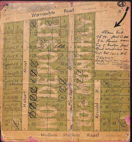 Ringwood and District Historical Society
Map, Residential Subdivision Allotment Layout on Mullum Mullum Road, Hobart Street, Paxton Street, Arnold Street and Warrandyte Road, Ringwood, Vic. (Undated, circa 1920)
Map on cardboard backing clipped from Subdivision Plan 7578 - Part of Crown Allotment 32, Parish of Warrandyte, County of Evelyn.H.C. Crouch, Licensed Surveyor, 443 Lt Collins Street, Melbourne. Includes handwritten real estate sales notations and Certificate of Title reference - Vol 3922 Fol 784242. -
Bendigo Historical Society Inc.
Map - CITY OF BENDIGO RESURVEY SHEET 1, 5/06/1903
Map: City of Bendigo resurvet sheet 1. Parish plan ( number 219 in Map Cupboard 1)map, bendigo, parish plan, bendigo resurvey -
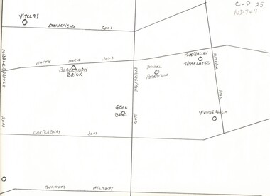 Whitehorse Historical Society Inc.
Map, Potteries, n.d
Sketch map of location of potteries in the area bounded by Middleborough, Springfield, Mitcham Roads and Burwood Highway.Sketch map of location of potteries in the area bounded by Middleborough, Springfield, Mitcham Roads and Burwood Highway.Sketch map of location of potteries in the area bounded by Middleborough, Springfield, Mitcham Roads and Burwood Highway.potteries, vitclay pipes pty ltd, blackburn brick and tile co., geal bros., wunderlich limited, australian tesselated tile co. pty ltd., daniel robertson australia pty ltd -
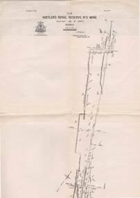 Bendigo Historical Society Inc.
Map - STRUGNELL COLLECTION: HUSTLER'S LINE OF REEFS, BENDIGO, September 1913
Map, Hustler's Line of Reefs, Hustler's Royal Reserve No.2 Mine, Bendigo Plan. Plate No.V1 (6). Bulletin No 33 Signed H.A.Whitelaw Underground survey Office Bendigo September 1913Underground Survey Office, Bendigo.map, bendigo, hustler's royal reserve no. 2 mine* -
 Ballarat Tramway Museum
Map, City of Ballarat, 2015 Begonia Festival, 2015
.1 Colour photocopy of map of events for the 2015 Begonia Festival in the Ballarat Botanic Gardens showing what was happening, toilets etc and that Free Vintage Tram rides were available. Taken from item 6232.2 .2 - Pamphlet - fold out A2, full colour for the 2015 Ballarat Begonia Festival with details of events and attractions at the gardens. Contains the map.trams, tramways, begonia festival, map, btm -
Stawell Historical Society Inc
Map, Jallukar, County of Borung, 1971
Jallukar, County of Borungstawell