Showing 2247 items in the category Documentation with item type Map
-
 Moorabbin Air Museum
Map (item) - TAA map of Australia & Papua New Guinea 10th edition
-
 Bendigo Historical Society Inc.
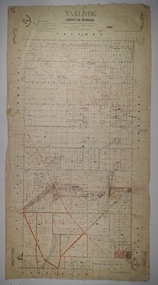
Map - YALLOOK, 25/02/1876
Map: Parish of Yallook, County of Bendigo. Parish plan. Map dated 25/02/1876.map, bendigo, parish plan, yallook -
Whitehorse Historical Society Inc.
Map, Yarra River, 1839
Copy of T.H. Nott's original survey of 'Yarra Yarra River' taken from 'Lilydale' by Grace Aveling.Copy of T.H. Nott's original survey of 'Yarra Yarra River' taken from 'Lilydale' by Grace Aveling. Covers area from Templestowe to Yarra Glen.Copy of T.H. Nott's original survey of 'Yarra Yarra River' taken from 'Lilydale' by Grace Aveling. maps, yarra river -
Whitehorse Historical Society Inc.
Map, Yarran Dheran Reserve, n.d
Yarran Dheran Walking Trailnon-fictionYarran Dheran Walking Trailyarran dheran, schwerkolt cottage, walking trails -
 Bacchus Marsh & District Historical Society
Map, Lerderderg District Proposed Irrigation and Water Supply Trust (B) Plan Showing Proposed Works
The 1886 Irrigation Act in Victoria introduced the first legislation in Australia designed to enable the creation of a detailed scheme for agricultural irrigation. Part of the legislation saw the use of government funds for local irrigation projects. These local projects were managed by local irrigation trusts. The Lerderderg Irrigation and Water Supply Trust was formed in 1890. This map depicts the proposed area of the Trust and proposed works such as channels and weirs.Printed paper map of the proposed Lerderderg District Irrigation and Water Supply area showing proposed works. The map scale is 40 chains + 1 inch. The Lerderderg District lies within the Parishes of Korkuperrumul and Merrimu in the County of Bourke. At the top of the map above its title is the letter 'B; in capital lettering. A series of proposed channels are indicated on the map in red lines. A proposed weir site and alternative weir site are also indicated on the map. irrigation, water supply, lerderderg irrigation and water supply trust -
Federation University Historical Collection
Map, City of Ballarat and Borough of Sebastopol Road Map
Road map of the City of Ballarat and the Borough of Sebastopol. WGS 85 Centroid 37 degrees 33 feet 56 inches south 143 degrees 51 feet 09 inches eat E-W- extent: 9 km N-S- extent: 11.5 kmballarat, sebastopol, map, plan, ballarat shire -
Bendigo Historical Society Inc.
Map - WALL MAP
Paper on canvas wall map. Street and Road map of City of Greater Bendigo, Borough of Eaglehawk and Surrounding Districts. Wooden hanging rod on top edge. Plastic rod on lower edge. Light brown background. Tw hanging tapes at centre of top hanging rod. Printed in black and red. Includes Street indexes, historical information and key to points of interest.eaglehawk, map -
 Ballarat Tramway Museum
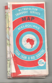
Map, Ministry of Transport, "Melbourne Transport Services Map - Tram, Train and Bus Services", 1974
Coloured map of Melbourne's Tram and Bus routes, route numbers, rail lines, detailed for the central part of Melbourne and insert section for Frankston. On rear description of routes, private bus routes and map of Melbourne metro lines. Has contact details for bookings and lost property etc. Priced 15c. Inscription dates the map as 1974. Yields information about public transport services in Melbourne as a comparison with that of Ballarat.Fold out map (27 sections 9 across x 3 deep), printed on paper.trams, tramways, railways, melbourne, map, tram and bus services, mmtb, minister for transport, public transport -
Whitehorse Historical Society Inc.
Map, Blackburn and Doncaster, 1950, 1950
Map of part of Blackburn and Doncaster from Morgan's Street Directory, 1950. Advertisement for G.S. Grover, Real Estate Agent, Main Road, Doncaster.Map of part of Blackburn and Doncaster from Morgan's Street Directory, 1950. Advertisement for G.S. Grover, Real Estate Agent, Main Road, Doncaster.Map of part of Blackburn and Doncaster from Morgan's Street Directory, 1950. Advertisement for G.S. Grover, Real Estate Agent, Main Road, Doncaster.maps, blackburn, grover, g.s., doncaster -
Stawell Historical Society Inc
Map, Rupunyup and Marnoo Railway Construction District 1900, 11/06/1908
Map Shows Rail Lines. Glenorchy Lubeck Rupunyup Marnoo Murtoa MinyipMap Showing line to be Constructed from Rupunyup to Newall's Corner Marnoo.Marnoo Railway Trustrailways -
 Robin Boyd Foundation
Map, H M Gousha Company, Chicago
walsh st library -
 Bendigo Historical Society Inc.
Map - FRED COWIE COLLECTION: AERIAL MAPS OF HEATHCOTE/EPPALOCK, 28-9-60
Map, Heathcote C4, Aerial Survey of Victoria,Photo-map prepared by Department of Crown Lands and Survey from photographs taken in 1960. Copied photographically at the Central Plan Office.Date 28-9-60,C.P.O.Neg.No.21590.Scale 4 inches to 1 mile. Fred Cowie,46 McIvor Rd,Bgo..Central Plan Office.map, heathcote, fred cowie -
 Bendigo Historical Society Inc.
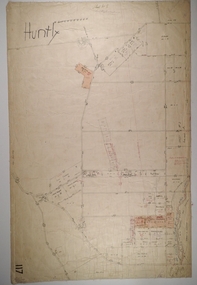
Map - HUNTLY, Circa 1870's
Map: Huntly, Hand draughted parish planmap, bendigo, parish plan, huntly -
Stawell Historical Society Inc
Map, Victorian Geological Map, 1963
Victorian Geological Mapstawell, mining -
 Bacchus Marsh & District Historical Society
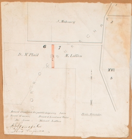
Map, Land required for a public highway near Rowsley, Victoria. Circa 1880s
This map indicates portions of land in the Parish of Gorrockburkchap near Rowsley which was required for construction of a road. The land required was leased to a Michael Laffan. Other blocks of land nearby owned or leased by D. McPhail and J. Mahoney are also indicated on the map. The date of the map is not known. However newspaper reports in the Bacchus Marsh Express on the 18 March 1882, page 3, column 3 mention land occupied by McPhail and Laffan near Rowsley in connection to the construction of a public road.Single page map showing land occupied by farmers D. McPhail and Michael Laffan which was required for a public highway. Scale 6 chains to inch. Part of a set of maps which are pasted into a bound volume containing 76 maps or plans in total. High resolution digital image stored on BMDHS computer network. Signed by Shire Engineer, W.E. Standfieldrowsley victoria maps -
Bendigo Historical Society Inc.
Map - HAWKESTONE, 17/11/1915
Map: Hawkestone, County of Talbot. Parish plan ( number 178 in Map Cupboard 1)map, talbot, parish plan, hawkestone, county of talbot -
Whitehorse Historical Society Inc.
Map, Lake Road estate Blackburn, c1960
Plan of subdivision of Lake Road Estate, 36 sites.Plan of subdivision of Lake Road Estate, 36 sites. Agent: Mark Padgett & Co Pty Ltd.Plan of subdivision of Lake Road Estate, 36 sites. lake road estate, blackburn, lake road, blackburn, ottawa avenue, blackburn, anjaya court, blackburn, leons court, blackburn -
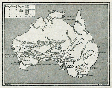 Ballarat Heritage Services
Map, Exploration of Eyre, Sturt, Stuart, Gregory, Burke, and Wills
Copy of a map from 'A Short History of Australia' by Ernest Scott.map, explorers, exploration, stuart, gregory, melbourne, perth, sydney, darling river, murray river, adelaide, albany, fitzroy river, flinders river, brisbane, great australian bight, gulf of carpentaria, mount grey, forrest -
Bendigo Historical Society Inc.
Map - NEILBOROUGH : COUNTY OF BENDIGO, 13-10-27
Map. Neilborough, County of Bendigo, Tandarra, Whirrakee, Huntly, Nerring, Yarraberb, Yallook, Photo-Lithographed at the Department of Lands and Survey, Melbourne by W.J. Butson 13-10-27, Price 1/- (number 77 in map cupboard 1)W.J. Butson.map, bendigo, neilborough -
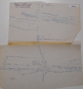 Bendigo Historical Society Inc.
Map - DEVONSHIRE MINES - MAP WITH UNITED DEVONSHIRE & PRINCESS ALEXNDRA (ALEXANDRA)
Hand drawn map taken from Caleb Thomas Plan, Sheet 774 (No ?1) 4/12/1885. Map shows shaft No 18 (Princess Alexndra [Alexandra], Lease No 4567) and shaft No 19 (United Devonshire) depths of some of the levels and geological information. Two mismatched pieces of drafting sheet stuck together with sticky tape and staples.mine, gold, devonshire mines, united devonshire, princess alexndra, caleb thomas plan -
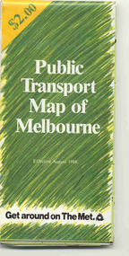 Ballarat Tramway Museum
Map, Ministry of Transport and The Met, "Public Transport Map of Melbourne" - "Effective August 1988", 1988
Map - Pocket size - folded - public transport map of Melbourne, printed in colour on art paper, showing public transport services in greater Melbourne, an index of localities. The City Saver area shown in detail. On the rear, route numbers, line maps of tram routes, train lines, outer metropolitan services, ticketing information, Transport Neighbourhoods, . Shows the St Kilda and Port Melbourne light rail lines. Price $2. Shows "The Met" logo. On front under The Met logo and above the scale bar is "Effective 1/7/1988". Niltrams, tramways, melbourne, map, routes -
![Map, Public Lands Office, Township of Sandridge [cartographic material] / lithographed at the Public Lands Office, March 30th 1859, 30 March 1859](/media/collectors/4f729f5897f83e0308601603/items/63c6354eae7bf372478c58b7/item-media/63c635d4ae7bf372478c7627/item-fit-380x285.jpg) Mission to Seafarers Victoria
Mission to Seafarers VictoriaMap, Public Lands Office, Township of Sandridge [cartographic material] / lithographed at the Public Lands Office, March 30th 1859, 30 March 1859
The map shows where the land of the Customs House was and where the Bethel church was built in 1860. It also shows the name Gregory, a family of land owners who became the managers of the new building on the same site in 1889.sandridge, bethel church, customs house, gregory -
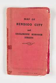 City of Greater Bendigo - Civic Collection
Map, Bolton Brothers Printers, Map of Bendigo City and Eaglehawk Borough Streets, Unknown
Produced by local company Bolton Brothers. Suitable for the glove box of car.Fold out map with a book style red and black printed front and back cover. Includes a three page index of street names and reference points. city of greater bendigo commerce, city of greater bendigo tourism -
Bendigo Historical Society Inc.
Map - WOODSTOCK : COUNTY OF BENDIGO, 26-9-17
Map. Woodstock, County of Bendigo, Derby, Leichardt, Marong, Shelbourne, Laanecoorie, Tarnagulla. L.5512. Photo-Lithographed at the Depatment of Lands and Survey, Melbourne, by W.J. Butson, 26-9-17. Price 1/-. By authority A.J. Mullett, Government Printer, Melbourne. (number 19 in map cupboard 1)A.J. Mullett, Government Printer.map, bendigo, woodstock -
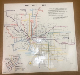 Melbourne Tram Museum
Map, Melbourne & Metropolitan Tramways Board (MMTB), "Tram Route Guide", Aug. 1979
Full colour map or poster printed on clear plastic with an adhesive peel off backing sheets, titled "Tram Route Guide". Map dated 8/79, showing proposed extension to Bundoora, routes with route numbers and names of main destinations. Has notes about the services, weekend and telephone numbers for information. 1979 2 copies held. See Reg Item 1098 for a smaller version of this map.trams, tramways, mmtb, map, routes, posters -
Bendigo Historical Society Inc.
Map - SANDHURST (PART), Circa 1880's
Map: Parish plan showing an area from McKenzie/View streets to Long Gully ( number 232 in Map Cupboard 1)map, bendigo, parish plan, sandhusrt, mckenzie street , view street, long gully -
 Bendigo Historical Society Inc.
Map - FORTUNA HUSTLER'S MINE - LONGITUDINAL SECTION OF THE FORTUNA HUSTLER'S MINE
Longitudinal Section of the Fortuna Hustler's Mine on the Hustler's Line of Reef, Bendigo. Bulletin No 33, Plate No IV. Shows poppet legs at the surface level, Datum Line 750 feet above Sea Level, levels and their depths, the amount of gold per ton and some geographical features. Geological Survey of Victoria emblem and signed by H A Whitelaw, Underground Survey Office, Bendigo. Note - Plates 4, 8, 13, 20, 26 & 31 form a Longitudinal Section from Fortuna Hustler's to Hustler's Consols Mine. mining, parish map, fortuna hustler's mine, longitudinal section of the fortuna hustler's mine, geological survey of victoria, h a whitelaw, underground survey office bendigo, hustler's line of reef, hustler's consols mine -
Whitehorse Historical Society Inc.
Map, Site for Wesleyan Church, Nunawading, 1855
Photocopy of manuscript map showing names of landholders.Photocopy of manuscript map showing names of landholders. Note on verso: Plan of allotments in the City of Melbourne appropriated to the Wesleyans. Site for Wesleyan Church, Nunawading 1848 (Corner of Burwood and Elgar Roads - S of Burwood, W of Elgar)Photocopy of manuscript map showing names of landholders. churches, wesleyan church, burwood, burwood road, burwood, elgar road, burwood, maps -
Merbein District Historical Society
Map, Birdwoodton (Merbein) Allotments - Sec A, 4 Mar.1938
-
Moorabbin Air Museum
Map (item) - Pan Am map of world flights 1980