Showing 2323 items in the category Documentation with item type Map
-
 Ballarat Tramway Museum
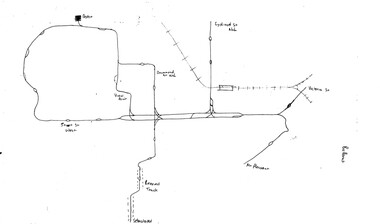
Map, Ballarat and Bendigo tram systems, 1960's or 1970's
Yields information about the extent of the Ballarat and Bendigo tramway systems and possibly has a strong association with the work of Tom Murray.Set of two hand drawn maps of the Ballarat and Bendigo tram systems, showing loops, terminus, depots and rail lines, including out of use loops and reserved track. Possibly made during the 1960's or early 1970's. Drawn on lined foolscap paper - have been torn from a pad.trams, tramways, map, drawings, ballarat, bendigo -
 Bendigo Historical Society Inc.
Map - SANDHURST SHEET 6, 1947
Map: Sandhurst sheet 6. Parish plan ( number 196 in Map Cupboard 1)map, bendigo, city streets, sandhurst -
 Bacchus Marsh & District Historical Society
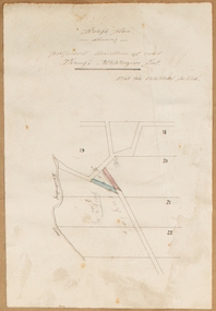
Map, Rough plan showing proposed deviation of road through McKenzie's Flat
The date of this map or plan is uncertain. McKenzie's Flat is a bushland picnic area on the Lerderderg River in the Lerderderg State Park close to Bacchus Marsh. Single page map showing a proposed deviation of the road near the McKenzie's Flat area close to Bacchus Marsh. The proposed deviation is shaded in pink, The existing road section to be replaced is shaded in blue. No scale is indicated. Part of a set of maps which are pasted into a bound volume containing 76 maps or plans in total. High resolution digital image stored on BMDHS computer network. mckenzies flat bacchus marsh, bacchus marsh roads and streets -
Bendigo Historical Society Inc.
Map - LYELL : COUNTY OF BENDIGO, 24-10-84
Map. Lyell, County of Bendigo, Eppalock, Sedgwick, Sutton Grange, Hawkestone, Kimbolton, Coliban River, Myrtle Creek. State School. Photo-Lithographed at the Department of Lands and Survey, Melbourne by J. Noune, 24-10-84. (number 71 in map cupboard 1)J. Nounemap, bendigo, lyell -
 Bendigo Historical Society Inc.
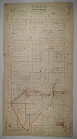
Map - YALLOOK, 25/02/1876
Map: Parish of Yallook, County of Bendigo. Parish plan. Map dated 25/02/1876.map, bendigo, parish plan, yallook -
Whitehorse Historical Society Inc.
Map, Schwerkolt property by Arthur Schwerkolt, 1993
Map of Schwerkolt property and rough plan of original stone house produced by Arthur Schwerkolt. Also copy of covering letterschwerkolt cottage -
Bendigo Historical Society Inc.
Map - SUTTON GRANGE : COUNTY OF BENDIGO, 21-7-22
Map. Sutton Grange, County of Bendigo, County of Talbot, Mandurang, Ravenswood, Harcourt, Faraday, Hawkestone, Lyell, Sedgwick, Myrtle Creek, Victorian Water Supply - Main Line of Aquaduct from Malmsbury to Sandhurst. By authority A.J. Mullett, Government Printer, Melbourne. Photo-Lithographed at the Department of Lands and Survey, Melbourne by W.J. Butson 21-7-22. Price 1/-. (number 124 in map cupboard 1)A.J. Mullett, Government Printer, Melbourne.map, bendigo, sutton grange -
 Wodonga & District Historical Society Inc
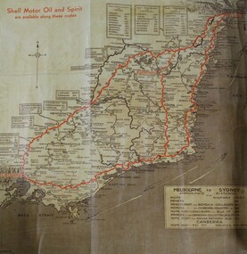
Map - Hamilton-Smith Collection Highway Map c. mid 1900s
The Hamilton-Smith collection was donated by the children of Grace Mary Hamilton-Smith nee Ellwood (1911-2004) and William John (Jack) Hamilton-Smith (1909-1984) who settled in Wodonga in the 1940s. The Ellwood family had lived in north-east Victoria since the late 1800s. Grace’s mother, Rosina Ellwood nee Smale, was the first teacher at Baranduda in 1888, and a foundation member of the C.W.A. Rosina and her husband Mark retired to Wodonga in 1934. Grace and John married at St. David’s Church, Albury in 1941. John was a grazier, and actively involved in Agricultural Societies. The collection contains significant items which reflect the local history of Wodonga, including handmade needlework, books, photographs, a wedding dress, maps, and material relating to the world wars.This item has well documented provenance and a known owner. It forms part of a significant and representative historical collection which reflects the local history of Wodonga. It contributes to our understanding of social life in mid-twentieth century Wodonga, as well as providing interpretative capacity for themes including local history and social history.A brown and tan highway map with red road markings showing the south east of Australia from Melbourne to Sydney map, highway, wodonga, melbourne, sydney, travel, hamilton-smith, hamilton-smith collection, driving, drive, car, road -
Bendigo Historical Society Inc.
Map - SECTIONS ACROSS BENDIGO GOLDFIELD
Map in three sections showing sections across Bendigo Gold Field, showing anticlines, synclines, faults, stratigraphical zones and mines along the reef lines. Key shows rock types Castlemaine, Bendigo B1, B2, B3 and B4, and Lancefieldian. First part of map shows sections A-A, B-B and C-C. Reef lines drawn with mines listed: Fault line shown are the Carshalton, Stafford, New Chum, Virginia and Clarence. A datum line shows 600 ft above sea level. On bottom of plan: ' Prepared in the Geological Survey Office, Bendigo, under the direction of H. Herman, late Director of Geological Survey, from surveys by H.S. Whitelaw, Field Geologist, assisted by E.S. Usher, A.J.J. Moore and R.A. Keble.' Second section of map shows sections D-D, and E-E. Fault lines listed are the Tambour Major fault, Carshalton fault, Stafford fault, Nell Gwynne fault, New Chum fault, Deborah fault. Third section shows sections F-F and G-G. Fault lines listed are the Bird Reef fault, Kangaroo Gully fault, Langdon fault, Carshalton fault, Nell Gwynne fault, Spring Gully fault, Hustlers fault, Gravel Hill fault, Ordes fault, Thanet fault. This map forms part of the Geological Survey of Victoria, Structure of Bendigo Goldfield report, No. 47, 1923. H.Herman, late Director of Geological Survey.Geological Survey of Victoriabendigo, gold mining, reef line maps -
 Bendigo Military Museum
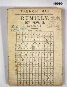
Map - TRENCH MAP, WW1
-
Moorabbin Air Museum
Map (Item) - Maps of Northern Australia and New Guinea, AUS RNC 5 and 6 radio navigation maps
-
Federation University Historical Collection
Map, Robinson's Ballarat Street Map, c1972, 1970s
A coloured fold-out street map of Ballarat. It also includes a district road map.ballarat, map, ballarat streets -
 Melbourne Tram Museum
Map, Victorian Railways (VR), "Melbourne and Suburbs", 1956
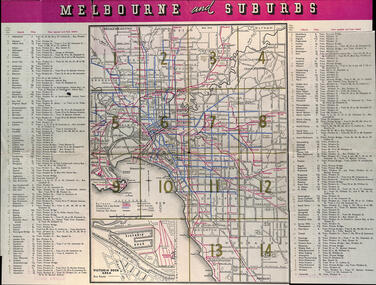
Map printed by the Victorian Railways in 1955 gives places of interest, some facts about Melbourne, and amusements, with the map showing rail, tram, and railway bus routes, suburbs, golf links, sporting grounds, and municipalities. The Bourke St tram route to East Preston is shown but not the Nicholson St East Brunswick line which opened during mid 1956. Provides a detailed list of suburbs, miles from the GPO, and how reached from where. Notes it was published in Jan. 1956 by the VR Public Relations and Betterment Board.Demonstrates a Victorian Railways printed map of MelbourneMap - 8 fold printed in colourmaps, melbourne, tramways, bus routes, railways -
 Melbourne Tram Museum
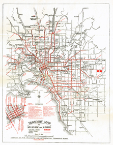
Map, Melbourne & Metropolitan Tramways Board (MMTB), "Tramway Map of Melbourne and Suburbs", c1939
Folded map (4 x 2) by Melbourne and Metropolitan Tramways Board, c1939, of Melbourne tramways, showing tram routes (cable, electric and VR), bus routes, railway lines, major points of interest and major streets. No printing or information on the rear. Once part of another document with remnants of glue on the rear top left hand edge. See Reg Item 801 for a 1927c map.trams, tramways, map, mmtb, vr, cable trams -
 Bendigo Historical Society Inc.
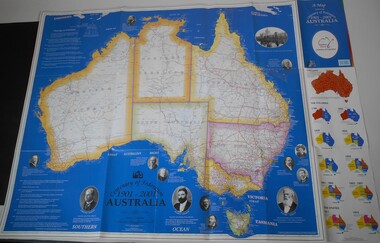
Map - CENTENARY OF FEDERATION MAP OF AUSTRALIA
Map of Australia printed for the Centenary of Federation 1901-2001. Description of the footsteps to federation and starting at left pictures of: John Forrest (first premier of Western Australia) - Edmund Barton (Australia's first Prime Minister) - Charles Kingston (premier of South Australia) - Catherine Helen Spence (first woman to run for political office) - Alfred Deakin ( Australia's first deputy Prime Minister) - John Quick (Force behind the people convention) - Andrew Inglis Clark (Attorney General of Tasmania) - Henry Parkes (Premier of New South Wales) - Robert Garran (helped draft the final version of the Constitution) - George Reid (Premier of New South Wales) - Maybanke Wolstenholme (leading women' s suffrage and Federation campaigner) - Samuel Griffith (former Queensland Premier) - The Exhibition Building, Melbourne - Vaiben Louis Solomon (represented the Northern Territory). On the right the evolution of the colonies and the states from 1788 to 1915.australia, history, centenary of federation -
 Ringwood and District Historical Society
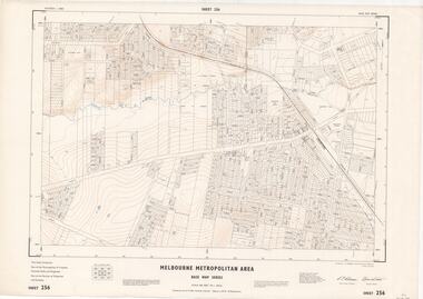
Map - Melbourne Metropolitan Area Base Map Series, Sheet 256 - Ringwood area, 1962
Map prepared by Dept of Lands and Survey and MMBW from State Aerial Survey December 1956 and Cadastral Survey information December 1962. This sheet comprises parts of the Municipalities of Croydon, Ferntree Gully, and Ringwood, and Parishes of Ringwood and Scoresby.Scale: 400 feet to 1 inch. Contours at 5 feet vertical interval. By Authority: A.C. Brooks, Commonwealth Printer, Melbourne. -
 Ringwood and District Historical Society
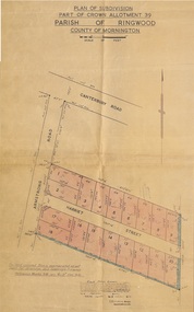
Map - Plan of Subdivision, Part of Crown Allotment 39, Parish of Ringwood, County of Mornington - 1949
Map showing residential allotments numbered 1 to 18 on Armstrong Road and Harriet Street, Heathmont, Victoria.Certification signed and dated by Russell Francis Kinnane, Licensed Surveyor, 12th October, 1949. -
Bendigo Historical Society Inc.
Map - LEICHARDT, Circa 1870's
Map: Leichardt, Hand draughted parish plan ( number 300 in map cupboard 1 )map, bendigo, parish plan, leichardt -
Stawell Historical Society Inc
Map, Physical description Concongella South, Counties of Borung & Ripon, 1957
Concongella South, Counties of Borung & Riponstawell -
Whitehorse Historical Society Inc.
Map, Boronia Road, Vermont, 1970
Enlargement of aerial photograph of Boronia Road, Vermont. State Aerial Survey 1970 Run 37Enlargement of aerial photograph of Boronia Road, Vermont. State Aerial Survey 1970 Run 37Enlargement of aerial photograph of Boronia Road, Vermont. State Aerial Survey 1970 Run 37boronia road, vermont, lusk drive, vermont, morack road, vermont south, allison court, vermont, trinian street, vermont, cosgrove street, vermont, mawson court, vermont, aerial photographs -
 Ballarat Heritage Services
Map, Central Europe and the Mediterranean during World War One
Map of the World as it was during World War One. map of the world, world war one, france, spain, england, ireland, germany, austria-hungary, rumania, servia, albania, greece, bulgaria, russia, asia minor, turkey, egypt, tripoli, morocco, algeria, tunis -
 Bendigo Historical Society Inc.
Map - MARKS COLLECTION: CLAIM MAP SANDHURST
Original hand drawn map showing lease holders along Mt. Korong Road, Sandhurst area. Names include Gold Mines Co., Hercules Co., H. Koch, Prince Alfred Co, Advance Co., J. Steane, Skeals, Abel & Co., Mounts(?) Bay co., Wellington Co., Waterloo Co., Endeavour Co., W.H. Langdon, Bridgman & Co. Written in blue pencil on top RH corner in script Syme Well, Nova Ste (indecipherable), German Aleno Co., Concord, Rae. Written on back of map in black pen 'Maps'.map, bendigo, mining leases -
Port Melbourne Historical & Preservation Society
Map, G S Williams, City Engineer, City of Port Melbourne, Dec 1963
Map of City of Port Melbourne (brick areas marked in colour), 1963.G. S. Williams (City Engineer)town planning, g s williams, troedel and cooper -
Bendigo Historical Society Inc.
Map - MANDURANG : COUNTY OF BENDIGO, 1962
Map. Mandurang, County of Bendigo. Sandhurst, Strathfieldsaye, Sedgwick, Lockwood. By authority A.C. Brooks, Government Printer, Melbourne. Drawn and Reproduced at the Department of Lands and Survey, Melbourne, 1962, Price 2/-. (number 67 in map cupboard 1)A.C. Brooks, Government Printer, Melbourne.map, bendigo, mandurang -
Merbein District Historical Society
Map, Horticultural Blocks - Merbein, c.1920's
blocks, merbein west blocks, merbein blocks -
 Ballarat Tramway Museum
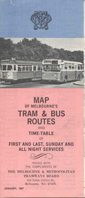
Map, Survey and Mapping for MMTB, "Map of Melbourne's Trams and Bus routes and all night services", Jan. 1967
Fold out sheet coloured map, 12 portions or folds, - title - "Map of Melbourne's Trams and Bus routes and all night services" map shows trams lines, route numbers, terminal points, bus routes, railway lines, blow up of city area with places of interest and key. On rear details, places of interest, suburb index, index to routes, first and last services, Sunday am services, all night bus services and locations of depots and head office. 2nd copy added 11-8-2006. Images of document - scanned to A3 size and overlapping added 30/10/13 On rear "out of date" stamp and 1 "cancelled" stamp - red ink.trams, tramways, melbourne, map, tram & bus services, all night services -
 Melbourne Tram Museum
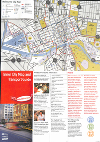
Map, City of Melbourne, "Inner City Transport Map", c1990
Map - 6 fold DL - full colour titled "Inner City Transport Map", providing information for Tourist Information centres, Metlink. Melbourne City Tourist Shuttle, and two maps, one provided by Melway giving a list of attractions. Published by City of Melbourne, Melway and Metlink with each of their logos.trams, tramways, map, public transport, city of melbourne, metlink -
 City of Whittlesea
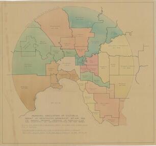
Map - Maps, Municipal Association Of Victoria groupings of councils for representation, 1936
Map was produced as part of Municipal Association of Victoria report on Metropolitan Government, 18 May 1936. Map shows proprosed groupings of municipalities for election of representation to the MAV Board. Map includes net annual value of rateable property within each municipality. The net rateable value for metropolitan area of the Shire of Whittlesea in 1936 was £20,102. Maps, paper. Produced as part of Municipal Association of Victoria report on Metropolitan Government, 18 May 1936. Map shows proprosed groupings of municipalities for election of representation to the MAV Board. council, municipal association of victoria -
 Bendigo Historical Society Inc.
Map - HUSTLER'S REEF & HUSTLER'S REEF NO 1 MINES - LONGITUDINAL SECTION OF THE HUSTLER'S REEF & HUSTLER'S
Longitudinal Section of the Hustler's Reef & Hustler's Reef No 1 Mines on the Hustler's Line of Reef. Bulletin No 33, Plate No XX. Note - Plates 4, 8, 13, 20, 26 & 31 form a Longitudinal Section from Fortuna Hustler's to Hustler's Consols Mine. Geological Survey of Victoria emblem. Signed by H A Whitelaw, Underground Survey Office Bendigo, September 1913. Shows the two shafts with their levels and depths. Also shows geographical features and yields of gold and amalgam per ton. .mining, parish map, hustler's reef & hustler's reef no 1 mines, geographical survey of victoria, underground survey office bendigo, h a whitelaw -
 Ringwood and District Historical Society
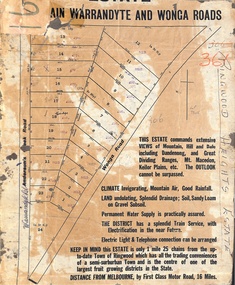
Map, Partially Trimmed Copy of Ringwood Heights Estate, Ringwood, Vic. - circa 1923
Clipped copy of a subdivision advertisement on cardboard backing. Sales notations on numbered allotments in Andersons's Creek Road (later Warrandyte Road) and Wonga Road, Ringwood. Handwritten title reference - LP7305. Captions - This Estate commands extensive views of mountain, hill and dale including Dandenong and Great Dividing Ranges, Mt. Macedon, Keilor Plains, etc. The outlook cannot be surpassed. Climate invigorating, mountain air, good rainfall. Land undulating, splendid drainage; soil, sandy loam on gravel subsoil. Permanent water supply is practically assured. The district has a splendid train service, with electrification in the near future. Electric light & telephone connection can be arranged. Keep in mind this estate is only 1 mile 25 chains from the up-to-date town of Ringwood which has all the trading conveniences of a semi-suburban town and is the centre of one of the largest fruit growing districts in the state. Distance from Melbourne by first class motor road, 16 miles.