-
 Glenelg Shire Council Cultural Collection
Negative - Glass Plate Negative - Coastline looking towards Cape Grant, 1890-1910
Glass plate negative. Costline looking towards Cape Grant. -
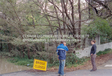 Eltham District Historical Society Inc
Negative - Photograph, Diamond Creek floodwaters near Jarrold Cottage opposite Dalton Street, Eltham, February 2005
Roll of 35mm colour negative film, 7 stripsKodak GC400-8diamond creek, eltham, floods, dalton street, jarrold cottage -
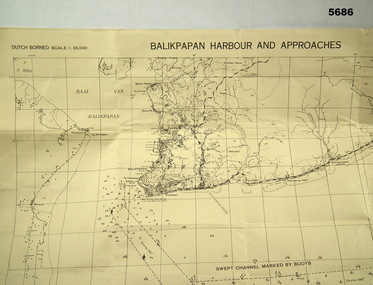 Bendigo Military Museum
Map - MAP, DUTCH BORNEO
Map identified height of land in area and depth of ocean on approached to Balikpapan Harbour. Identified piers, streets and defences and potentially used for landing or combat in the area. MAP PRODUCED BY 2/1 AUST ARMY TOPO SQN CO. Large Yellow paper map with scale of 1:36,000 of Dutch Borneo Balikpapan Harbour and it's approaches. Map folded into 8.balikpapan harbour, maps -
Whitehorse Historical Society Inc.
Map, State Electoral Provinces, 1978
State Electoral Provinces 1975 redivision (1977 subdivisions) Scale 1:90,0000State Electoral Provinces 1975 redivision (1977 subdivisions) Scale 1:90,0000State Electoral Provinces 1975 redivision (1977 subdivisions) Scale 1:90,0000victoria. parliament. legislative council, electoral boundaries -
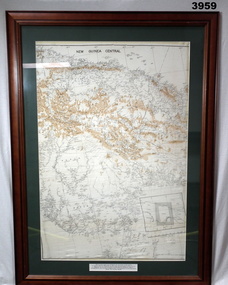 Bendigo Military Museum
Map - MAP, NEW GUINEA FRAMED, C. 1941 onwards
Map of central section of New Guinea. Black print on white background with mountain ridges in tan. Map is mounted with green border. Brown wooden frame, glass front, white cardboard backing with wire hanging strap on back. Map prepared under the direction of RAAF Headquarters.Printed in black top centre: “NEW GUINEA CENTRAL” Printed on border under map: “These escape maps were carried in the zip pocket of life jackets by fighter pilots in WW2. This map was presented to A.S.R. on 12.7.79 by Councillor Ian McKenzie, Mayor of Eaglehawk, who served as a fighter pilot in 78th SDN in the SW Pacific area during 1943-44.”map, new guinea, central, raaf -
Stawell Historical Society Inc
Map, Plan View Township Area showing Known old workings 2003, 13 June 2003
Coloured Printing outline of lease of Gold Mine Horizontal Drives shown in BrownStawell Gold Mine. Scale 1:7500. Fri 13 June 2003mining -
Whitehorse Historical Society Inc.
Map, Britannia Rise, 2012
Photos and plans of Britannia Rise.Photos and plans of Britannia Rise.Photos and plans of Britannia Rise.britannia rise', whitehorse road mitcham, no 569-571, mitcham railway station, eastlink, britannia mall, kenneth jones real estate -
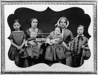 Eltham District Historical Society Inc
Negative - Photograph, Members of the Hill family, early Eltham settlers, c.1860
Mrs Georgina Hill (wife of Henry), nee Reynolds (of Research, Vic.) in cap [possibly misidentified by donor - see note below] with Mrs Isaac Hill and her children (left to right) Amelia Hill, (born 1853) Mrs Isaac Hill with baby Isaac (born 1860, Eltham) on her lap. Mary Jane Hill (born 1857, Eltham) seated on Mrs Henry Hill's lap and Bob Hill. The Hill family were early settlers of the Eltham area. Daguerreotype photo enclosed in a leather bound clam shell box with felt lining and gold trim. Donated by Mrs Ivy Edna Hill, 4/1 Bridge Street, Eltham, 4 June 1966 and includes copy of her note identifying the people. Daguerreotypes were one of the first forms of early photographs. They initially appeared in Europe in 1839 and were produced in large numbers to the early 1850s but were superseded by more modern and flexible forms of technology by 1860. The photo was usually formed on a thin copper plate with light sensitve silver iodide. They have a mirror-like appearance and the image itself was mirrored. They were usually inserted into a case or frame made of wood bound in leather or velvet and cost about one guinea in Australia, the equivalent of a week's wages. With the advent of the gold-rush and growing population came an increase in numbers of photographers both studio and travelling. The daguerreotype process was protected by patents and could only result in a single image from which no copies could be made. With new technology involving wet colloidion glass plate negatives and albumen paper prints of which multiple copies could be produced at significantly reduced cost, the dauguerreotype quickly fell out of favour. An accompanying note with the photo written by Edna Hill of 4/1 Bridge Street Eltham dated 4 June 1966 states: "Dear Mr Watson, I think the enclosed old time photograph will be of interest to you. It would have been taken about 1860. The two ladies are the wives of the original pioneers of the Hill family. The one in the cap was the wife of Henry Hill, the other of Isaac Hill. The children are those of Mrs Isaac Hill, and grandchildren to Henry Hill. The little girl on the left is Amelia, the baby Isaac, the second girl is Mary Jane, and the boy on the right is Bob Hill. They grew up tobe Uncles and Aunts of my late husband. I greatly appreciated a letter received a few months ago per Cr Pelling, from the Shillinglaw Cottage Committee. Yours sincerely, Edna Hill" Victorian birth registrations show Mary Jane Hill was born 1857 in Eltham (9879 / 1857) and Isaac Hill at Eltham in 1860 (1972/1860) NOTE: Mrs Isaac Hill was Ellen Fitzsimons (1834-1863), mother to Henry Hill. Mrs Georgina Hill, wife of Henry cannot be the lady in the cap as she was not born till 1864. Georgina Reynolds (1864-1927) married Henry Hill (1862-1948) in 1884. This lady has significant wrinkling of the face, especially around her mouth. It is possible that she is the mother of Mrs Isaac Hill (Ellen Fitzsimons) who was Isabella Fitzsimons (nee Ferguson).This photo forms part of a collection of photographs gathered by the Shire of Eltham for their centenary project book,"Pioneers and Painters: 100 years of the Shire of Eltham" by Alan Marshall (1971). The collection of over 500 images is held in partnership between Eltham District Historical Society and Yarra Plenty Regional Library (Eltham Library) and is now formally known as 'The Shire of Eltham Pioneers Photograph Collection.' It is significant in being the first community sourced collection representing the places and people of the Shire's first one hundred years.Digital image 4 x 5 inch B&W Negsepp, shire of eltham pioneers photograph collection, eltham, hill family, research (vic.), women, amelia hill, bob hill, daguerreotype, early settlers, georgina hill (nee reynolds), isaac hill, mary jane hill, mrs henry hill, mrs isaac hill, ellen hill (nee fitzsimons), isabella fitzsimons (nee ferguson) -
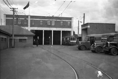 Melbourne Tram Museum
Negative, Wal Jack, 21/04/1945 12:00:00 AM
Black and white negative, by Wal Jack, of S class 168 on the western road at Footscray Tram depot. Shows the depot layout. There are three buses in the yard - advised by Paul Kennelly via David Kemp by e-mail: Two Leyland Cubs sandwiching a Federal, all with MMTB bodies. The Cub closest to the camera is No 49 new 8/36, and I guess the other Cub is in the same 41-50 sequence. The Federal was new the following year and was numbered in the sequence 53-60.trams, tramways, footscray depot, buses, s class, tram 168 -
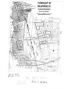 Halls Gap & Grampians Historical Society
Map - Photocopy
Photocopy of map of Heatherlie TownshipTownship of Heatherlie; Parish of Boroka; County of Borung; scale measurement; R.O. Robson Authorised Surveyormaps, heatherlie township -
Moorabbin Air Museum
Map - RAAF Navigational Maps
Historical Details: . Description: Official Wartime Maps NewGuinea, New Britain etc AAP Date: 1940-45 Author: RAAF Amended to AL Publisher: RAAF Pages: 15 Maps Binding: Content/Keywords. Level of Importance: -
Glenelg Shire Council Cultural Collection
Negative - Glass Plate Negative - Crowd of people watching events at Portland Show, 1890-1910
Portland Show c. 1890-1910Glass plate negative. Images shows a crowd of people watching events at Portland Show.Front: 'Portland Show' -
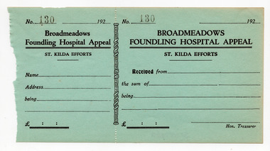 St Kilda Historical Society
Financial record - Receipt form, Broadmeadows Founding Hospital Appeal, 1920s
Unused receipt forms that have been removed from a receipt book for St Kilda's contributions to an appeal in aid of the Broadmeadows Foundling Hospital Appeal.Blue coloured paper, printed in black on one side, perforated vertically at about one third along its length. Ten copies heldbroadmeadows foundling hospital, hospital fundraising -
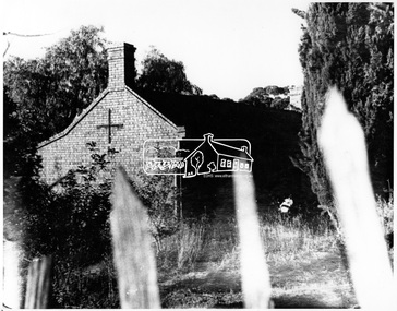 Eltham District Historical Society Inc
Negative - Photograph, George W. Bell, Shillinglaw Cottage, Main Road, Eltham, c.1964
Shillinglaw Cottage on its original site (present day 895 Main Road) showing old picket fence c.1964. The cottage and land were purchased by the Shire of Eltham as the site for a new shire office building. The cottage was destined for demolition but members of the community concerned at losing one of the areas earlist buildings (built c.1859) initiated a fund-raising campaign to save the cottage. In 1964 the cottage was dis-assembled, all the bricks numbered and reassembled several hundred meters to the south on a site between the Gahan house and the Eltham Railway Trestle Bridge (present-day Panther Place), which bcame known as the Eltham Common.This photo forms part of a collection of photographs gathered by the Shire of Eltham for their centenary project book,"Pioneers and Painters: 100 years of the Shire of Eltham" by Alan Marshall (1971). The collection of over 500 images is held in partnership between Eltham District Historical Society and Yarra Plenty Regional Library (Eltham Library) and is now formally known as the 'The Shire of Eltham Pioneers Photograph Collection.' It is significant in being the first community sourced collection representing the places and people of the Shire's first one hundred years.Digital image 4 x 5 inch B&W Negsepp, shire of eltham pioneers photograph collection, eltham, shillinglaw cottage, fences, george w. bell collection, houses, main road -
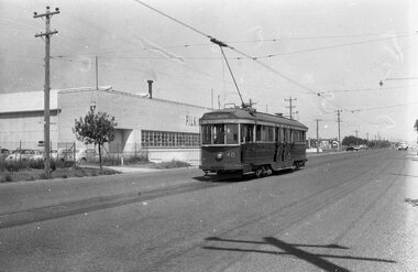 Ballarat Tramway Museum
Negative - Tram 40 at the North terminus, early 1956
Photo shows Geelong tram 40 at the North Terminus, with the Pilkington glass factory behind. The tram has the destination of Belmont. One of a set of photos was taken between 15/2/1956 and 3/3/1956 when services operated only between Belmont and North before the final closure of the Belmont route on 25/31956 and that bogie tram 31 is not shown on the board, having gone to Ballarat on 15/2/1956 - see item 5554. See item 8213 for an article on the Geelong system by Keith Kings. Yields information about the Geelong operations toward the closure of the tram system and the North terminus.Black and white Negative - 120 sizetramways, geelong, geelong depot, tram 40, north -
 Bendigo Military Museum
Map - EASTER NEW GUINEA NAVIGATION CHART, RAAF, Aug 1943
From the collection of "Maxwell Lennox Matheson" No.418447 RAAF. Enlisted 22/5/1942 Aged 19. Discharged 19/2/1948 - Rank FLTLT.This map is in colour. It is made of a stiff paper and has a map printed on both sides. Side1 - scale 1:2,315,000. 31.72 Nautical miles = 1 inch. It shows Eastern half of New Guinea. It also shows New Britain and New Ireland. Manus Island is at the top. Side 2 - Scale 1:1,000,000 - this shows Manus Island on right side, top of New Guinea at bottom edge (Wewak) and some other little islands. The map on side 1 has numerous navigation tracks and calculations in pencil. i.e. LAE, KOKODA, PORT MORESBY.ww2, raaf, new guinea -
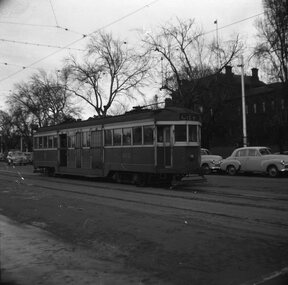 Ballarat Tramway Museum
Negative, Geoff Grant, 6/07/1954 12:00:00 AM
Negative No. 280 and colour print made by colour laser printer (stored in folder ) of W2 496 in bound along St. Kilda road, outside Victoria Barracks, 6/7/1954. Tram has destination of "CITY". Photo by Geoff Grant. Hi res scan of negative and image updated 19/5/2020.trams, tramways, melbourne, st kilda road, victoria barracks, tram 496 -
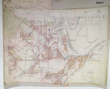 Bendigo Military Museum
Map - Map of Newcastle NSW 4 Inch - 1 Mile 1910, Australian Intelligence Corps, Nov 1910
In 1909 the Australian Army Headquarters realized that mapping in Australia was either non existent or inadequate for Military use. It was requested that Australia borrow Survey personnel from the UK Royal Engineers (RE) for a two-year detachment. On 11 April 1910 four RE NCOs arrived in Melbourne comprising CPL J Lynch, and LCPLs AH Barrett, EF Davies and R Wilcox. LCPL Barrett had 12yrs experience with RE. They were aiming at producing eight map sheets per year covering about 7,000 square miles (18,000 square Km) This map sheet of the Newcastle area was produced using plane table methods and was surveyed and hand drawn by LCPL A Barrett Oct - Nov 2010. It was unique because it was now produced on an accurate gridded base and included contouring. Lynch and Davies transferred to the Royal Australian Engineers (RAE) whilst Barrett and Wilcox returned to the UK in June 1913. Barrett returned to Australia in 1915 and also enlisted in the RAE and served until 1919.A gridded Map of Newcastle NSW area scale four inches to one mile with 25 feet interval contouring. Coloured hand drawn map produced in 1910. Signed by " A Barrett LCPL Royal Engineers"royal australian survey corps, rasvy, fortuna, army svy regt, army survey regiment -
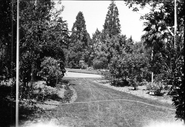 University of Melbourne, Burnley Campus Archives
Negative - Black and white negative, Garden View, 1922-1923
Garden Viewj.l. provan, garden view, trees -
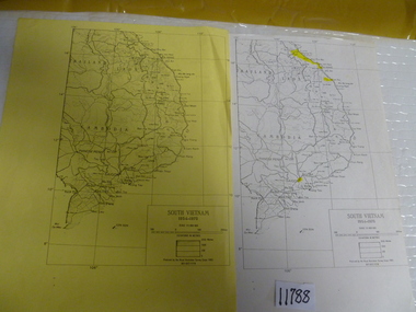 National Vietnam Veterans Museum (NVVM)
Map, 1983 (exact)
Two maps of South Vietnam dated 1954-1975. One on plain paper, one on yellow papermaps, south vietnam -
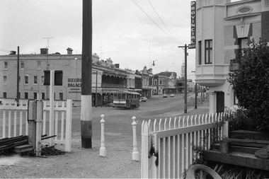 Ballarat Tramway Museum
Negative - Set of 2, Campbell Duncan, 28/02/1971 12:00:00 AM
Yields information about tram operations and the street views at the Ballarat Station area and Lydiard St North.Set of 2 photographs taken on 28/2/1971 by Campbell Duncan of trams at the Ballarat Station level crossing, Lydiard St North.\ .1 - tram - inbound - after with Reid's Palace and the Provincial Hotel in the background. .2 - No. 30 outbound to Lydiard St North with the Ballarat B signal box and the Provincial Hotel in the background. Tram has Bliss bombs tilt tram to read pack advert.trams, tramways, lydiard st north, railway station, level crossings, signals, tram 30 -
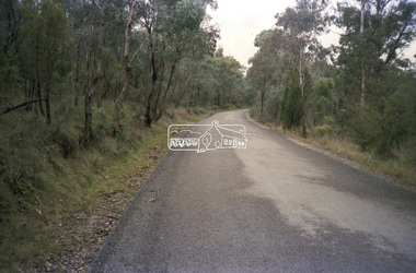
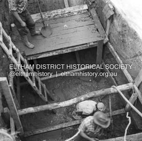 Eltham District Historical Society Inc
Negative - Photograph, J.A. McDonald, Henley Road at Watsons Creek, Apr. 1961
Henley Road at Watsons Creek showing excavation at western pier Rock at contract level, slight underground flow Early April 1961Record of various Shire of Eltham infrastructure works undertaken during the period of 1952-1962 involving bridge and road reconstruction projects, sometimes with Eltham Shire Council Project Reference numbers quoted. It was during this period that a number of significant improvements were made to roads and new bridges constructed within the shire that remain in place as of present day (2022). In many situations, the photos provide a tangible visible record of infrastructure that existed throughout the early days of the Shire. The album was put together by or under the direction of the Shire Engineer, J.A. McDonald.infrastructure, shire of eltham, bend of islands, cr. charis pelling, henley road, henley road bridge, kangaroo ground, oxley bridge, watsons creek, w.e. wolf, bridge construction, road construction, 1961-04 -
Whitehorse Historical Society Inc.
Map, Highbury Road, c1970
Enlarged aerial photo of Highbury Park area.Enlarged aerial photo of Highbury Park area.Enlarged aerial photo of Highbury Park area.highbury road, burwood east, gareth drive, burwood east, blackburn road, burwood east, bennett avenue, burwood east, rae street, burwood east, joy street, burwood east, folkestone road, burwood east, burwood east primary school no. 454, aerial photographs -
Whitehorse Historical Society Inc.
Map, The Parish of Nunawading, 1853
Photocopy of manuscript plan with allotments numbered and some named.Photocopy of manuscript plan with allotments numbered and some named. Note on verso: The Parish of Nunawading in the County of Bourke; lithographed at the Surveyor General's office by J.Jones Jan 18th 1853. Endorsed Sale Plan 271. Dray tracks, water holes and terrain indicated.Photocopy of manuscript plan with allotments numbered and some named. land subdivision, maps, parish of nunawading, jones, j -
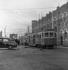 Ballarat Tramway Museum
Negative - Set of 2, Geoff Grant, 25/06/1955 12:00:00 AM
Negatives No. N354 and N355 and black and white prints made by a laser printer (stored in folder ) of tram SW6's 888 and 887 at Malvern Depot in Coldblo Road prior to travelling to Preston Depot on AETA tour (Australian Electric Traction Association) on 25/6/1955. 1616.1 - In route number box of 888 is letter "B". 1616.2 - 887 - with letter "A" in route number box and sign with slogan "Save traffic congestion, move people, not vehicles." Negative scanned hi res and imaged updated 22/5/2020.trams, tramways, melbourne, malvern depot, coldblo road, aeta tour, tram sw6 888 tram sw6 887 -
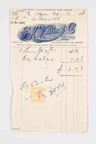 City of Greater Bendigo - Civic Collection
Financial record - Invoice, E.M Vains & Co
Ernest Morton Vains (1881 - 1951) was a local business man and Bendigo councillor who arrived in Bendigo in 1897 aged 16 from Kerang. In 1916 he founded the firm E M Vains and Co with his brother Sidney and they operated from Hargreaves Street in Bendigo with branches in Elmore, Mitiamo, Dingee, Knowsley, Heathcote and Prairie. E. M. Vains was a member of the City Council from 1922 - 1926 and was elected Mayor on August 29th, 1924. He played a prominent role in many of the City's community and industry groups and was a member of the Rotary Club which was founded in 1925 and a member of the Corona Lodge of Freemasons. Single page invoice from E.M. Vains and Co Auctioneers, Stock and Station Agents Bendigo. Letterhead features the unique R M Vains & Co logo with a bulls head, printed in royal blue ink.city of bendigo mayor, mayor vains, city of greater bendigo commerce, making a nation exhibition, mayoress vains, freemason -
Whitehorse Historical Society Inc.
Map, Parish of Nunawading, 1892
Map copied from 'Directory maps - parishes and counties' 26 Nov 1892.Map copied from 'Directory maps - parishes and counties' 26 Nov 1892. Lithographed by G.S. Bonne[y]. Map includes roads, railway, stations, names of property owners. 2nd copy 'for copying'.Map copied from 'Directory maps - parishes and counties' 26 Nov 1892. maps, parish of nunawading -
Glenelg Shire Council Cultural Collection
Financial record - Receipt - to K.S. Anderson, Portland, 10/01/1979
Receipt from International Biographical centre to K.S. Anderson.k s anderson, financial record, receipt -
 Eltham District Historical Society Inc
Negative - Photograph, Eltham Shire Council, Unidentified road, Eltham district, c.1985
One of a series of images on roll of film shot by Eltham Shire Council officers focussing on road and street infrastructure maintenance and upgrades and new rollover kerb and channel profilesRoll of 35mm colour negative film, 5 stripsKodak CP100 5094infrastructure, road construction, road drainage, road sealing, roadworks, shire of eltham, streets, streetscape -
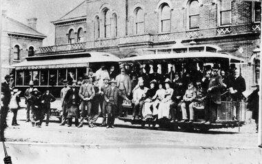 Melbourne Tram Museum
Negative, 11/11/1885
Copy negative of a photograph of the opening of the Richmond Cable Tramway 11/11/1885 Has the Richmond Town Hall in the background. See Reg Item 4643 for a prints ex Keith Kings and Colin Jones.On rear of Photo ex Colin Jones "Copied 14/2/83" in two locations "150L 76%^ B/W? and on bottom edge "MMTB 1885".trams, tramways, cable trams, mto co, opening, richmond