Showing 1652 items in the category Documentation with item type Plan
-
 Clunes Museum
Plan - ARCHITECTURAL DRAWINGS, BUTTER FACTORY CLUNES, C. 1894
PLAN OF CLUNES BUTTER FACTORYHAND DRAWN PLAN ON GLASS PAPER OF CLUNES BUTTER FACTORY INCLUDING ELEVATION AND SECTION A.B. SCALE 8FT TO 1 INCHclunes buildings, clunes butter factory -
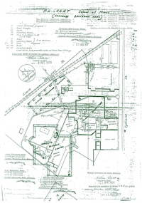
Moorabbin Air Museum
Plan (Item) - CAC Plans, Commonwealth Aircraft Corporation Plans Multiple Components
Commonwealth Aircraft Corporation -
Moorabbin Air Museum
Plan (item) - C.A.C Power/Condensing Unit Test Support Frame
-
Glen Eira Historical Society
Plan - Jasper Road, 236-246, McKinnon
Three items relating to the valuation of this property: 1/A typed copy of a three page valuation of 236-246 Jasper Road, McKinnon, by valuator W V Scott for Atlantic Union Oil Co Pty Ltd, dated 11/08/1961. Accompanying this are a hand-drawn plan of the property and handwritten working notes for the valuation. 2/One additional page of correspondence from W V Scott to Atlantic Union Oil, dated 11/08/1961, informing them that the occupier of the property, L A Atkinson’s Garage and Panel Beating Works, was aware of the valuation taking place. 3/Field Purchase Order for the valuation of the property from Atlantic Union Oil Company Pty. Limited dated 19/07/1961.jasper road, mckinnon road, mckinnon, atkinson l.a, webb d mr, l.a atkinson’s garage and panel beating works, moorabbin council, atkinson mr, atlantic oil co pty ltd, morris g h, scott w v, motor vehicle repair shops, garages, petrol stations, factories, land use, land values, anderson's garage & panel beating works -
Port Melbourne Historical & Preservation Society
Plan - Concept, Boulevard upgrade at Sandridge Beach, traffic treatment, 2003
Plans. Traffic treatment. Concept for the Boulevard upgrade at Sandridge Beach. Dated October 2003local government - city of port melbourne, engineering - roads streets lanes and footpaths -
Glenelg Shire Council Cultural Collection
Plan - Plans / Line Drawings - Port of Portland Authority Slipway Bilge Blocks, Wooden Vessel, Jane Kerr, victoria, 12/10/1982
PORT OF PORTLAND AUTHORITYFront: '8' - black texta, top right corner -
 Kew Historical Society Inc
Plan - Subdivision Plan, Maxwelton, Kew, 1920-1940
Pru Sanderson, in her groundbreaking ‘City of Kew Urban Conservation Study : Volume 2 - Development History’ (1988), summarised the periods of urban development and subdivisions of land in Kew. The periods that she identified included 1845-1880, 1880-1893, 1893-1921, 1921-1933, 1933-1943, and Post-War Development. These periods were selected as they represented periods of rapid growth or decline in urban development. An obvious starting point for Sanderson’s groupings involved population growth and the associated economic cycles. These cycles also highlighted urban expansion onto land that was predominantly rural, although in other cases it represented the decline and breakup of large estates. A number of the plans in the Kew Historical Society’s collection can also be found in other collections, such as those of the State Library of Victoria and the Boroondara Library Service. A number are however unique to the collection.The Kew Historical Society collection includes almost 100 subdivision plans pertaining to suburbs of the City of Melbourne. Most of these are of Kew, Kew East or Studley Park, although a smaller number are plans of Camberwell, Deepdene, Balwyn and Hawthorn. It is believed that the majority of the plans were gifted to the Society by persons connected with the real estate firm - J. R. Mathers and McMillan, 136 Cotham Road, Kew. The Plans in the collection are rarely in pristine form, being working plans on which the agent would write notes and record lots sold and the prices of these. The subdivision plans are historically significant examples of the growth of urban Melbourne from the beginning of the 20th Century up until the 1980s. A number of the plans are double-sided and often include a photograph on the reverse. A number of the latter are by noted photographers such as J.E. Barnes.The subdivision, ‘Maxwelton’, included four lots in East Kew, at the northwest corner of Burke Road and Cotham Road. Lot 3 is identified as the location of an existing house. The site of the subdivision equates to that parcel of land where a contemporary block of three storey apartments at 1245 Burke Road is now located.subdivision plans - kew, mazwelton subdivision, burke road -- kew (vic.), cotham road -- kew (vic.) -
 Mission to Seafarers Victoria
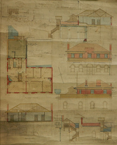
Plan - Architectural drawings, Walter Butler, 1916
An original group of plans drawn by Walter Butler who was also the architect of the Central Institute, Siddeley Street in 1906 and the Mission to Seamen building at 717 Flinders St that is still in use today. The early Port Melbourne onshore Mission gradually transformed from a 'wooden shack' to a one storey brick building designed by architect Frederick Williams in 1888. The St Nicholas chapel was added in 1915. Walter Butler was commissioned to add a second storey in 1917. The building retained its functions until 1937 when the Art Deco Mission, designed by Morris was built. The building has survived as a structure into the 21st century, and was incorporated as part of a multi-apartment development. Historical architectural record of Walter Butler's work. Walter Butler was a renowned architect and friend of the Fairfax family.Coloured architect's drawings of the proposed plans for Chaplain's Residence at Port Melbourne on heavy parchment. Including elevation drawings, floor plans and cross sections as well as architect's notes and measurements.Embossed architect's stamp in top right and left corners and bottom right corner "Walter R Butler [indecipherable] Melbourne" Printer's stamp on bottom right hand corner of rear "Printed by J. Creffield Propy. LTD. RIALTO, 493-5 Collins St. Melbourne"plans, walter richmond butler (1864–1949), mission to seafarers, chaplains residence, beach street, nott street, port melbourne, mission to seamen, frederick williams -
 Port Melbourne Historical & Preservation Society
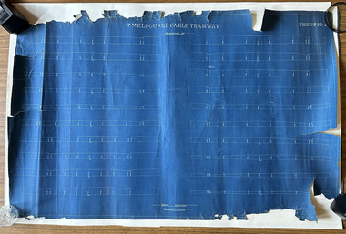
Plan, Pt Melbourne Cable Tramway, 1890s
One of three sheets of blueprints showing street configuration in Beach Street and Sandridge Road along Port Melbourne cable tram route. Indistinguishable signature of 'George ------ Esq., lower rightNotations in red crayon or penciltransport - tramways, transport - roads -
Moorabbin Air Museum
Plan (item) - Bristol Aeroplanes 170 schematic drawings, Assy of Pressure HD Centre Plane
The Bristol Aeroplane Company -
 University of Melbourne, Burnley Campus Archives
Plan, M. Drake et al, Site Location Plan of Incubator Building and Random Sample Laying Test for Burnley Gardens, 1967
Plan by Public Works Dept., Melbourne. M. Drake (draughtsman), R. G. Wilson, Chief Architect.m. drake, g.r. wilson -
 Bendigo Historical Society Inc.
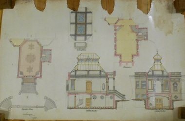
Plan - MARKS COLLECTION: SIDE AND FLOOR PLAN FORTUNA VILLA
Laminated plan, hand coloured, with side elevations and floor plans of Fortuna Villa entrance area. Basement, ceiling and first floor plans, with side elevations labelled Section A, B and (front view) Section C, D. On bottom of plan signed 'W. Beebe Architect' and 1/4' equals 1 foot.bendigo, buildings, fortuna villa -
University of Melbourne, Burnley Campus Archives
Plan, Geoff Olive, Geoff Olive Notes, 16.05.2015
site plan, campus plan, geoff olive, history -
University of Melbourne, Burnley Campus Archives
Plan, Design Concept for Quadrangle Entrance, 1990-2000
Design concept for quadrangle entrance. "Please pass on any comments to Michael Green." (1) View from Quad looking towards main building. (2) Plan.michael green, quadrangle entrance -
 University of Melbourne, Burnley Campus Archives
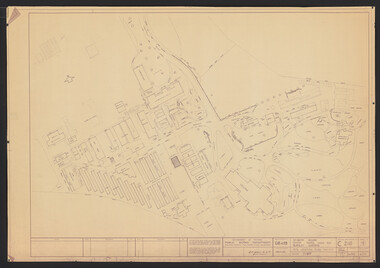
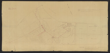
Plan, School of Horticulture -Burnley, 1950
Same layout as plan at B91.0471, but showing PMG cables, and buildings existing, proposed and temporary or for demolitionPlan showing layout of PMG cables and PMG plant. Area bounded by Swan St., Yarra Boulevard, orchard, vegetable garden, market garden and S.W. Boundary to Stockman's Cottage. PMG layout handwritten. On same plan as B91.0484 (original) and B11.0383.burnley school of horticulture, orchard, gardens, vegetables, stockman's cottage -
Glenelg Shire Council Cultural Collection
Plan - Ship Plan / Mould, n.d
Wooden pattern for mould for boat fitting. Tear drop shaped piece, sides concave, circular hole in centre. Painted white. -
 Federation University Historical Collection
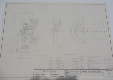
Plan - Engineering Drawing, 'Friction Clutch', 1974
Student's technical drawing ballarat school of mines, technical drawing, k. y. chin -
Federation University Historical Collection
Plan, Ballarat School of Mines New Workshops Hotwater Supply, 1941, 1941
Service plan for new workshops at the Ballarat School of Mines.ballarat school of mines, new workshops, buildings, hotwater service, plans -
Port Melbourne Historical & Preservation Society
Plan - Annotated and handcoloured by Peter Libbis to indicate his research into Libbis family residences and hotels on copy of a section of an MMBW map, Melbourne and Metropolitan Board of Works, c. 1980s
Peter LIBBIS obtained these copies from the MMBW when he researched his family history in the 1980s. He has annotated them, colour in hotels etc. Donated to Society in 1997.One of a group of 19 photocopies of various 20th century MMBW plans, annotated/coloured in to indicate residences of Libbis family and local hotels, by Peter LIBBIS in family and hotel research - Harper's and lagoon, 1950s?business and traders - hotels, built environment - domestic, transport - railways, melbourne and metropolitan board of works, libbis family -
University of Melbourne, Burnley Campus Archives
Plan - Photocopy, Edward Owens, Contour Plan of the Town of Richmond, 1873
Photocopy of Contour Plan of the Town of Richmond prepared by M. Egan, Architect and Edward Owens, Cont. Surveyor, 25.03.1873. Plan C. Shows proposed Main Drains and Horticultural Garden. From State Library of Victorian VSL 821.08 Richmond 1873"State Library Vic." in inkdrainage, burnley horticultural gardens, m. egan, edward owens, town of richmond, contour plan -
Port Melbourne Historical & Preservation Society
Plan - Drainage Improvements, Ross Street, Port Melbourne, Borough of Port Melbourne, 3 Nov 1892
Plan of Ross Street drainage improvement diversion drain, 1892.Signatures of J. J. Bartlett (Mayor), A. V. Heath (Borough Surveyor), W. Harrison, Laurence Brady (Contractor)engineering - canals and drainage, james john bartlett, arthur victor heath, town clerks, w harrison, laurence brady -
University of Melbourne, Burnley Campus Archives
Plan, Plans for Garden Bed, c. 1980
(1) Coloured elevation plan of plants. (2) Plan with key for Plant Name, Size and Colour.plants, gardens, flower beds -
 Federation University Historical Collection
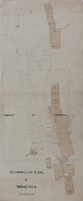
Plan, Gold Mining Lease Blocks at Tarnagulla, not dated
Printed plan with red shading showing gold mining lease blocks at Tarnagullaplan, mining leases, gold mining, tarnagulla, mining -
Moorabbin Air Museum
Plan (item) - C.A.C Support Bolt - Outer- Power Unit
EX250014 -
 Bendigo Military Museum
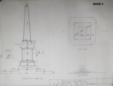
Plan - MONUMENT PLANS, C.1992
These plans were for a proposed Memorial to Ex Servicemen and Women to be erected in front of the Soldiers Memorial Institute in Pall Mall Bendigo. This building is now known as "The Bendigo Military Museum".1) .2) Two Cronaflex .004 thick black ink plans , scale 1 - 100showing front elevation and plan of a proposed Monument. Both plans are slightly different showing plan sections."Proposed Monument to Ex Servicemen and Women to be erected in Pall Mall Bendigo"brsl, smirsl, monument, plan, -
Glen Eira Historical Society
Plan - LEMPRIERE AVENUE
One item about this location 1/Excerpts (5 pages) from Andrew Wards Heritage Study vol 2, 3.6 on Lempriere Avenue and ‘Greenmeadows Gardens’ Historic Area include street plan and general view of Roselle Estate’, Greenmeadows Garden. Included in his description is mention of a large eucalypt in ‘Greenmeadows Gardens’ which pre-dates European settlement.streetscape, lempriere avenue, ‘greenmeadows gardens’, meadow street, alston grove, californian bungalow style, fences, spanish mission style, ‘greenmeadows house, lempriere w. g., meadow street, clarke william senior, ‘greenmeadows’, trees, balaclava road, orrong road, allan road, meadow street, lempriere john, kirton mr, dickson and yorston (pty ltd), lempriere ruby l mrs, dickson g c, yorston j c, st kilda east, east st kilda, roselle estate, east st kilda, east st kilda riding -
 Federation University Historical Collection
Plan, Plan Former Ballarat Gaol and Ballarat School of Mines Buildings, 1926/1927
After the closure or the Ballarat Gaol the space was taken over by the Ballarat SChool of Mines and the gaol building was demolished. The E.J. Tippett Library is now on the site of the former Gaol building.Copy of 1928 plans for the Ballarat Gaol, with two Ballarat School of Mines buildings marked on it - The Student Amenities building and the Learning Resource Centre (E.J. Tippett Library). It shows a 'future Teaching Building' which was never built.ballarat school of mines, ballarat gaol, plan, student amenities building, learning resource centre, e.j. tippett library, governor's residence, warden's residence -
 Kew Historical Society Inc
Plan, Melbourne & Metropolitan Board of Works : Borough of Kew : Detail Plan No.1576, 1904
The Melbourne and Metropolitan Board of Works (MMBW) plans were produced from the 1890s to the 1950s. They were crucial to the design and development of Melbourne's sewerage and drainage system. The plans, at a scale of 40 feet to 1 inch (1:480), provide a detailed historical record of Melbourne streetscapes and environmental features. Each plan covers one or two street blocks (roughly six streets), showing details of buildings, including garden layouts and ownership boundaries, and features such as laneways, drains, bridges, parks, municipal boundaries and other prominent landmarks as they existed at the time each plan was produced. (Source: State Library of Victoria)This plan forms part of a large group of MMBW plans and maps that was donated to the Society by the Mr Poulter, City Engineer of the City of Kew in 1989. Within this collection, thirty-five hand-coloured plans, backed with linen, are of statewide significance as they include annotations that provide details of construction materials used in buildings in the first decade of the 20th century as well as additional information about land ownership and usage. The copies in the Public Record Office Victoria and the State Library of Victoria are monochrome versions which do not denote building materials so that the maps in this collection are invaluable and unique tools for researchers and heritage consultants. A number of the plans are not held in the collection of the State Library of Victoria so they have the additional attribute of rarity.Original survey plan, issued by the MMBW to a contractor with responsibility for constructing sewers in the area identified on the plan within the Borough of Kew. The plan was at some stage hand-coloured, possibly by the contractor, but more likely by officers working in the Engineering Department of the Borough and later Town, then City of Kew. The hand-coloured sections of buildings on the plan were used to denote masonry or brick constructions (pink), weatherboard constructions (yellow), and public buildings (grey). Development in the 20th century has irreparably altered that part of Kew represented in this plan. In the block bounded by Cotham Road, Charles Street, Wellington Street and Gellibrand; just one house standing in 1903 remains. This block included two of the most historic houses in Kew: ‘Ordsall’ (later ‘Southesk’) and ‘Madford’ (previously ‘Elm Lodge’). Ordsall was the home of the second chairman of Kew, John Halfey. It contained some of the most significant interior murals in Kew, created for Halfey by artists working for Cullen & Co. It was demolished in 1960 to make way for the Kew Civic Centre. Elm Lodge had been built for William Siddeley in ca. 1864. Arthur Septimus King purchased it in 1874. The lower paddocks of Madford were sold in 1905 by his wife to the Borough of Kew and, after landscaping by George and Thomas Pockett, opened as the Alexandra Gardens in 1908. Elm Lodge/Madford was in 1922 to become St. Anthony’s Home for Little Children before its subsequent demolition in the 1980s.melbourne and metropolitan board of works, detail plans, maps - borough of kew, mmbw 1576, cartography -
![Plan, D.C. Bradbury, Student's [sic] Amenity Block Burnley Horticultural College, 1971](/media/collectors/52f2d90c9821f4163875a333/items/604ef24d1b68728908e39c1d/item-media/65e7f6354d1d8041ab1642dc/item-fit-380x285.jpg) University of Melbourne, Burnley Campus Archives
University of Melbourne, Burnley Campus ArchivesPlan, D.C. Bradbury, Student's [sic] Amenity Block Burnley Horticultural College, 1971
4 sheets showing Site Plan First Floor Elevations by D.C. Bradbury, Public Works Department Building Division, Victoria 28.7.1971.students, amenities, student amenities building, sab, d.c. bradbury, public works department -
Glenelg Shire Council Cultural Collection
Plan - Plan/ Line Drawing Portland Harbour Trust 'Galaxy', n.d
Front: '21' - black texta, top right cornerport of portland