Showing 1230 items in the category Memorabilia with item type Album
-
 Federation University Historical Collection
Album, Walter Haller, Motor School at SMB, 1978 - 1985
School of Mines Ballarat is a predecessor of Federation University2 x Beige folder with newspaper article and photographs mounted on cardboard. .1 1978 - 1982 .2 1983 - 1985Walter Haller label on front of (.2)walter haller, school of mines ballarat, len watts, convesion to ute, teesdale firetruck, wayne duggan, bill burgess, john heaps, warren drummond, paul davidson, ian clark, craig gillespie -
 Wodonga & District Historical Society Inc
Album - Ringer's River by Des Martin - Plate 9 - O'Day meets Elaine and Ruby
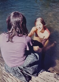
Resting in the shade above the river after he has brought his cattle over it, O'Day is disturbed by voices, and rolls over to discover Montieth's daughter Elaine, and her aboriginal companion, Ruby, enjoying themselves in the river. This first encounter with Elaine makes an impression on the young manager that is to last throughout his lifetime.The album and images are significant because they document literature written by a prominent member of the Wodonga community. The presentation of this precis was supported by several significant district families and individuals.Ringer's River Album Coloured photo Plate 9 Resting in the shade above the river after he has brought his cattle over it, O'Day is disturbed by voices, and rolls over to discover Montieth's daughter Elaine, and her aboriginal companion, Ruby, enjoying themselves in the river. This first encounter with Elaine makes an impression on the young manager that is to last throughout his lifetime. Geni Dynon as Ruby and Joan Lehmann as Elaine.des martin, many a mile, ringer's river, northeast victoria stories -
 Melbourne Tram Museum
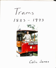
Album - Photo Album, Colin Jones, "Trams 1883 - 1993", 1990's
Photo Album, grey decorative front cover with a grey heavy card slip case, 30 leaves of heavy paper, each separated by a semi clear protective sheet. Compiled by Colin Jones with a title sheet "Trams 1883 - 1993" with Colin standing in the front of Brisbane Tramway Co. No. 47 at the Ferny Grove Museum. Bound with end papers. Photos retained by clear photo corners. Features photos by Colin of: Victor Harbor Surabaya Indonesia Melbourne cable trams, Sydney Steam tram in the UK Ballarat Bangkok Semarang Indonesia Adelaide Brisbane Melbourne Sydney Bendigo Launceston Osaka Japan Perth Kyoto Dalian Japan Fukuoka Japan Kanazawa Japan Hong Kong Sendai Kita Kyushu Hobart Lopburi Kobe Hiroshima Tokyo Matsuyama Japan Nagaski Various Museums in Australia. Sample pages only scanned.trams, tramways, melbourne, album, japan, indonesia, australian tramways -
 Eltham District Historical Society Inc
Album - Photograph Album, Alan Gardiner, Maribyrnong Munitions Sewage Treatment E.F.M, 1940-1941
alan gardiner collection, construction, maribyrnong munitions sewage treatment -
 Melbourne Tram Museum
Album - Robert Thomson Slide Collection, "Melbourne 1970 - 1979"
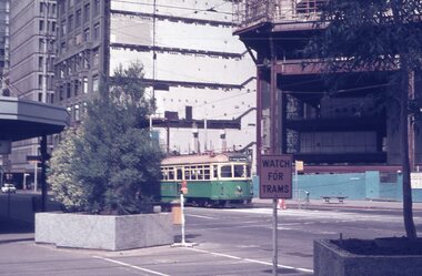
Photo - see pdf file for further information. Number Brief Description RT264 Elizabeth St, at Bourke St, with the construction of the State Savings Bank building (State Bank Galleria) underway. Bourke St Mall also under construction, Note tram warning Sign, tram 1065 - "West Maribyrnong" - route 57 RT265 St Kilda Road, tram 778 - "City" -route 59 RT266 St Kilda Road, tram 569 - "East Malvern Darling Road" -route 3 & tram 819 - "Glen Iris" - route 6 RT267 Swanston St, tram 538 - "City" - route 2A RT268 St Kilda Junction, tram 924 - "City" - route 5 RT269 St Kilda jct, tram 280 - "St Kilda Beach" - route 15 RT270 St Kilda Road, tram 507 - "City" - route 72 RT271 Nicholson St Gertrude St - tram7 - "East Preston Tyler St" - route 88 RT272 West Coburg, tram 778 - "Domain Rd" - route 55 RT273 Wests Road, tram 750 - "Moonee Ponds" - route 22 RT274 St Kilda Rd, tram 8 - "Special" RT275 Nicholson St Victoria Pde, tram 10W - "Special" RT276 L Class Queens way, "City" - route 54 RT277 Bourke St at Spring St, tram 998 - "East Coburg" - route 88 RT278 Nicholson St MMTB Bus, bus 562 - "Garden City via Port Melb" - route 2 RT279 Church St Burwood Rd Jct, tram 9 - "Special" RT280 Riversdale Rd at Camberwell Depot - "Burwood" - route 74 RT281 Balaclava Junction - tram 819 - "Kew Cotham Rd" - route 69 RT282 East Brunswick Terminus, tram 4 - "City Spencer St" - route 96 RT283 Peel St - tram 927 - "Special" RT284 East Brighton Terminus - tram 563 & tram 926 - "City" - route 64 RT285 Dandenong Rd Hawthorn Rd, tram 346 - route 64 RT286 Bourke St at Spring St, tram 34 - "North Fitzroy Park St" - route 97 RT287 Route 69 Terminus St Kilda - tram 369 - "Kew Cotham rd" - route 69 RT288 Route 78 Terminus St Kilda, tram 498 - "North Richmond" - route 78 RT289 Track relay, Fitzroy St, St Kilda RT290 Fitzroy St, St Kilda Demonstrates the work of Robert Thomson in photography, collection and/or production of slidesAssembled album in a black presentation folder of 27 colour slides, collected or produced by Robert Thomson. All photographs have been scanned and placed on the Museum's G drive. A list of all photographs with details has been compiled. melbourne, tramways, trams, track construction, elizabeth st -
 Wodonga & District Historical Society Inc
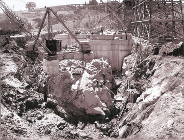
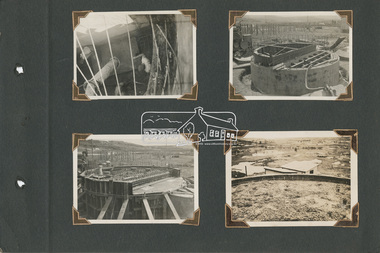
Album - Hume Reservoir Australia Album - Plans and Progress Photos - River Murray Water Scheme, Department of Public Works, N.S.W, 1927
This set of photos is from a leather bound album bearing the inscription "HUME RESERVOIR AUSTRALIA" plus 'The Rt. Hon. L. C. M. S. Amery, P. C., M .P.' all inscribed in gold. It was presented to The Rt. Hon. L. C. M. S. Amery, P. C., M. P, Secretary of State for Dominion Affairs on the occasion of his visit to the Hume Reservoir on 2nd November 1927. This album is of local and national significance as it documents the planning and development of the Hume Reservoir up to 1927. It was the largest water reservoir in the British Empire. The album records the pioneering engineering work that went into its construction.1. Locality Plan and Plan of Dam. The dam is about ten miles by road upstream from Albury and about three-quarters of a mile below the confluence of the Mitta Mitta River and the Murray River. Its main features consist of a concrete portion across the bed of the river with earth embankment at both ends. The foundations throughout are on hard granite, found at an average depth of about 40 feet below the surface, the centre line being located to take advantage of the most favourable rock levels.Heading on page "WORKS UNDER RIVER MURRAY WATERS AGREEMENT/HUME RESERVOIR" Beneath top diagram "FIG. 1. ELEVATION" Beneath second diagram "FIG. 2. PLAN" On map "LOCALITY PLAN"hume reservoir australia, river murray waters scheme, hume weir diagrams, hume weir location -
 Bendigo Military Museum
Album - ALBUM, PHOTOGRAPH, c.1918
The Soldier was probably FRED CARLTON.Photo album, fabric cover, leather strap with rusted metallic locking, contains 36 photos from WWI era? with black backing card, semi transparent cover of pictures have faint spider / spider web embossed pattern. Photos are civilian scenes from Gaza & a few of Gaza War Cemetery.Each picture has short text describing the subject.books-albums, photography-photographs -
University of Melbourne, Burnley Campus Archives
Album - Colour slides, Staff, 1985-1986
12 slides of staff? 1 Mar 86 "CRTM". 11 Jul 86. 1 Apr 85 M6 a tree. Not scanned.staff, crtm -
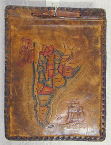 Mission to Seafarers Victoria
Album - Photographic album, Allan Charles Quinn
This photo album documents the voyage of Allan Quinn while he was in the merchant navy. The album and photos give a view of Quinn's trips around the world and the many places he visited. Leather-bound photo album. Cover is embossed with a colour map of South America.The cover contains the map of South America with a picture of a man with a pipe in his mouth in the top left-hand corner and a picture of a sailing ship in the bottom right. The inside front cover lists in handwritten columns: ports of call during 1947-48. There are three loose photos inside the front cover. album, photos, allan quinn, tourism, seafarers, sailors, seamen, ships -
University of Melbourne, Burnley Campus Archives
Album - Colour 35mm slides, D-B Plots Nowa-Nowa, 1969
Box of slides labelled "D-B Plot Nos 1 & 2 Nowa-Nowa August 1969.nowa-nowa, 1969, db plots -
 University of Melbourne, Burnley Campus Archives
Album - 35mm Colour slides, Pruning Day 1978, 1978
35 slides Jul 78.pruning day, 1978, open day, pruning day 1978 -
Moorabbin Air Museum
Album (item) - Historical Aviation Album Vol XVIII - incl Jeanie Hill & her Taylor J- Cub
-
 Wodonga & District Historical Society Inc
Album - Hume Reservoir Australia Album - Work inside levee bank, September 1924
This set of photos is from a leather bound album bearing the inscription "HUME RESERVOIR AUSTRALIA" plus 'The Rt. Hon. L. C. M. S. Amery, P. C., M .P.' all inscribed in gold. It was presented to The Rt. Hon. L. C. M. S. Amery, P. C., M. P, Secretary of State for Dominion Affairs on the occasion of his visit to the Hume Reservoir on 2nd November 1927. This album is of local and national significance as it documents the planning and development of the Hume Reservoir up to 1927. It was the largest water reservoir in the British Empire. The album records the pioneering engineering work that went into its construction.DEPARTMENT OF PUBLIC WORKS, N.S.W. RIVER MURRAY WATERS SCHEME. HUME RESERVOIR. 15. Work inside levee bank. Foundations of spillway showing granite foundations and a fault in the formation. New South Wales. September 1924.hume reservoir australia, river murray waters scheme, hume reservoir construction -
Bialik College
Album (sub-series) - Newspaper clippings, brochures and photos, 1963-1964, 1963-1964
1960s1960s -
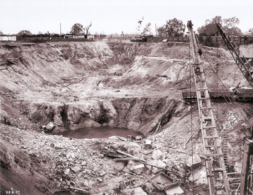 Wodonga & District Historical Society Inc
Album - Hume Reservoir Australia Album - View of South Wing Wall Foundations from Top of Tail Tower Pillar, August 1927
This set of photos is from a leather bound album bearing the inscription "HUME RESERVOIR AUSTRALIA" plus 'The Rt. Hon. L. C. M. S. Amery, P. C., M .P.' all inscribed in gold. It was presented to The Rt. Hon. L. C. M. S. Amery, P. C., M. P, Secretary of State for Dominion Affairs on the occasion of his visit to the Hume Reservoir on 2nd November 1927. This album is of local and national significance as it documents the planning and development of the Hume Reservoir up to 1927. It was the largest water reservoir in the British Empire. The album records the pioneering engineering work that went into its construction.DEPARTMENT OF PUBLIC WORKS, N.S.W. RIVER MURRAY WATERS SCHEME. HUME RESERVOIR. 30. View from Top of Tail Tower Pillar - South Wing Wall Foundations. This photograph was taken at right angles to the preceding one, (WHS 00723) ooking downstream along the cut for the South Wing Wall foundation. The granite is at a greater depth here than elsewhere and the cut will be twice as deep before the foundations are cleared. New South Wales. August 1927.hume reservoir australia, river murray waters scheme, hume reservoir construction -
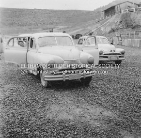
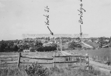 Eltham District Historical Society Inc
Album - Photograph, J.A. McDonald, Eltham-Diamond Creek Road, 21 Oct. 1953
Diamond Street Bridge 21st October, 1953 (showing York St., Bridge St., and Brisbane St in immediate foreground) View from intersection of Silver Street at Brisbane Street looking east. On the far side of Brisbane Street is the site of present-day Bunnings store. At the visible end of Brisbane Street where it turns right it then became Susan Street but today continues to the intersection with Bridge Street.Record of various Shire of Eltham infrastructure works undertaken during the period of 1952-1962 involving bridge and road reconstruction projects, sometimes with Eltham Shire Council Project Reference numbers quoted. It was during this period that a number of significant improvements were made to roads and new bridges constructed within the shire that remain in place as of present day (2022). In many situations, the photos provide a tangible visible record of infrastructure that existed throughout the early days of the Shire. The album was put together by or under the direction of the Shire Engineer, J.A. McDonald.infrastructure, road construction, shire of eltham, 1953-10-21, bridge construction, brisbane street, silver street, susan street, york street -
 Heidelberg Golf Club
Album - Photograph Album, Heidelberg Golf Club, New clubhouse 1998; Pennant photos; 60th anniversary 1988, 1988-1998
Album containing about 288 color photographs of Heidelberg Golf Club's new clubhouse 1998; Pennant photos; 60th anniversary 1988.Album #4 in the photograph collection at HGCDark green hard cover album. Contains approx. 288 colour photographs of 15x10cm and 1 black and white photo 16x21cm.heidelberg golf club, clubhouse redevelopment 1998, club house opening 1998, 60th anniversary 1988, pennant -
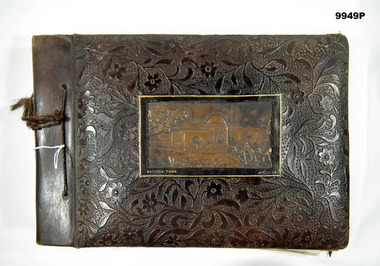 Bendigo Military Museum
Album - PHOTOGRAPHIC ALBUM, Mathew Rumbelow, c.1942-45
For details refer Cat No. 9947P on "Mathew Rumbelow" VX78073. Album contains some postcards and photos of 2/7th Field Regiment in Middle East and the Islands.Brown leather bound and tied with string, photo album. Fourteen pages of various photos of the 2/7th Field Regiment in the Middle East and Pacific. Photos stuck on brown cardboard sheets with white tissue paper in between. Some photos have come loose. Each is labelled in white writing. On front of Album is a 3D image of Rachels Tomb in Jerusalem. Also contains some colour postcards.Each photo in Album labelled.2/7th field regiment, mathew rumbelow, photo album -
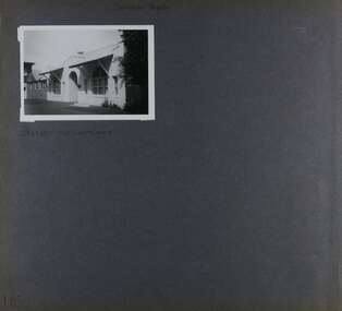
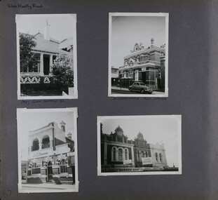 Glen Eira Historical Society
Album - Album page, Glen Huntly Road, Circa 1972
This photograph is part of the Caulfield Historical Album 1972. This album was created in approximately 1972 as part of a project by the Caulfield Historical Society to assist in identifying buildings worthy of preservation. The album is related to a Survey the Caulfield Historical Society developed in collaboration with the National Trust of Australia (Victoria) and Caulfield City Council to identify historic buildings within the City of Caulfield that warranted the protection of a National Trust Classification. Principal photographer thought to be Trevor Hart, member of Caulfield Historical Society. Most photographs were taken between 1966-1972 with a small number of photographs being older and from unknown sources. All photographs are black and white except where stated, with 386 photographs over 198 pages. The Former Elsternwick Post Office is on the Victorian Heritage Register H0640 with a full significance statement and also HO29 with the City of Glen Eira. Much of the Glen Huntly Road heritage retail strip is heritage listed in HO72 with the City of Glen Eira.Page 67 of Photograph Album with four photographs (three portrait and one landscape) of different properties on Glen Huntly Road - a house, Post Office, ANZ Bank and shops.Hand written: Glen Huntly Road [top left] / 1027 GLEN HUNTLY RD [under top left photo] / ELSTERNWICK POST OFFICE [under top right photo] / 67 [bottom left] trevor hart, glen huntly road, elsternwick, shops, caulfield, post offices, glenhuntly road, banks, brick houses, shopping centres -
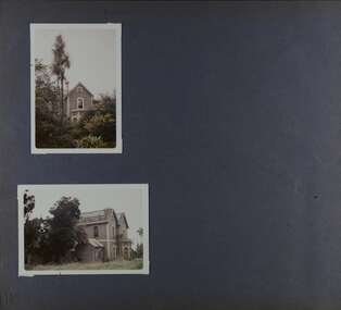
 Glen Eira Historical Society
Album - Album page, St Stephen's Presbyterian Church, Balaclava Road, Circa 1972
This photograph is part of the Caulfield Historical Album 1972. This album was created in approximately 1972 as part of a project by the Caulfield Historical Society to assist in identifying buildings worthy of preservation. The album is related to a Survey the Caulfield Historical Society developed in collaboration with the National Trust of Australia (Victoria) and Caulfield City Council to identify historic buildings within the City of Caulfield that warranted the protection of a National Trust Classification. Principal photographer thought to be Trevor Hart, member of Caulfield Historical Society. Most photographs were taken between 1966-1972 with a small number of photographs being older and from unknown sources. All photographs are black and white except where stated, with 386 photographs over 198 pages. From: Glen Eira Heritage Management Plan (1996) by Andrew Ward and Associates In 1905, the land was vacant in Balaclava Road, north side, from Kooyong Road east to the right of way, except for one house. A block of this land was acquired by the Presbyterian community and a timber church erected there in 1910. In time, a larger church was required. After several years of fund raising led by George Kinross, a new red brick St Stephen's church was built in 1926 to the design of architects Haddon and Henderson. George Currie was the builder and the cost of construction was £5,100.From: Glen Eira Heritage Management Plan (1996) by Andrew Ward and Associates: St Stephens has architectural importance as a noteworthy example of a Gothic Transitional design in the Arts and Crafts eclectic manner (see Stylistic Typology in National Trust's Historic Church's Study}. The facade treatment successfully combines Christian symbols with Gothic forms in the Arts and Crafts mode (comparable with Haddon's Presbyterian Church, Malvern (1906) and Haddon and Henderson's Oakleigh Church (1928). It is locally important as an example of Robert Haddon's work in Caulfield, where he also lived (4 Glenferrie St q.v.).Page 25 of Photograph Album - four black and white photographs of St Stephen's Presbyterian Church, with two photographs in landscape mode across the top showing information about who designed the building in one and showing the church name and year founded in the other; and two in portrait mode in the bottom section showing 2 different heavy wooden doors.Hand written: 25 [bottom left]trevor hart, caulfield north, balaclava road, george kinross, haddon and henderson, george currie, st stephen's, 1900's, 1920's, gothic transitional, christian symbols, arts and crafts, robert haddon, stylistic typology, gothic, presbyterian church, architects, red brick, doors, memorials -
 Eltham District Historical Society Inc
Album - Photograph, J.A. McDonald, Upper Yarra Dam, Oct. 1956
Upper Yarra Dam October 1956Record of various Shire of Eltham infrastructure works undertaken during the period of 1952-1962 involving bridge and road reconstruction projects, sometimes with Eltham Shire Council Project Reference numbers quoted. It was during this period that a number of significant improvements were made to roads and new bridges constructed within the shire that remain in place as of present day (2022). In many situations, the photos provide a tangible visible record of infrastructure that existed throughout the early days of the Shire. The album was put together by or under the direction of the Shire Engineer, J.A. McDonald.infrastructure, shire of eltham, bridge construction, road construction, 1956-10, upper yarra da, upper yarra reservoir -
 Warrnambool and District Historical Society Inc.
Album, Parliament House opening
This is an album used as a scrapbook to insert memorabilia of the 1927 opening of Parliament House in Canberra. The compiler of the scrapbook is unknown. The scrapbook includes small sepia-coloured photographs, a stamp, copies of photographs of the Duke and Duchess of York and a printed program of the 1927 Dedication of the Houses of Parliament. The photographs include the opening of Parliament House in 1927, the N.S.W. Mounted Police, notable military men of the time, the Melbourne escort for the Duke and Duchess of York procession and some views of Canberra. The states of Australia were created in 1901 with the establishment of Federation and the Australian Parliament met at Melbourne from 1901 to 1927 when the Australian Capital Territory was created and the first Australian Parliament House was built. This album is of minor significance as the material concerns mostly the opening of Canberra’s Parliament House in 1927, a national event. One photograph, that of C.A. Rogers, has local significance. He was a Warrnambool man who was part of the Melbourne mounted escort for the processional car of the Duke and Duchess of York in 1927 in MelbourneThis is a 12 page photograph album with a brown cardboard cover with the pages tied with brown cord. Front Cover: ‘Portraiture’canberra establishment, opening of parliament house in canberra 1927, warrnambool -
 Glen Eira Historical Society
Album - Album page, Cromarty, Sandham Street, Circa 1972
This photograph is part of the Caulfield Historical Album 1972. This album was created as part of a project from approximately 1966-1972 by the Caulfield Historical Society to assist in identifying buildings worthy of preservation. This album is related to a Survey the Caulfield Historical Society developed in collaboration with the National Trust of Australia Victoria and Caulfield City Council to identify historic buildings within the City of Caulfield that warranted the protection of a National Trust Classification. Photographers Jenny O’Donnell and Trevor Hart, members of Caulfield Historical Society. Some photographs are older and from unknown sources. All photographs are black and white except where stated. From Victorian Heritage Database citation for HO61 Presentation Convent, 28 Sandham Street Elsternwick https://vhd.heritagecouncil.vic.gov.au/places/35476 (as at 1/11/2020) The "Presentation Convent" is locally significant as a substantial late Victorian villa residence in Elsternwick and for its more recent role in the educational and spiritual lives of the community. https://vhd.heritagecouncil.vic.gov.au/places/65716 (as at 21/08/2021) National Trust Property No B2713 Typical of period but yet interesting for association with Horatio Beauchamp. Classified 26/11/1970 Victorian Heritage Database citation for HO61 Presentation Convent, 28 Sandham Street Elsternwick https://vhd.heritagecouncil.vic.gov.au/places/35476 A substantial two storeyed stuccoed asymmetrical Italianate villa residence, representative of its period, with two storeyed cast iron verandah and projecting facetted bay with trabeated treatment to the ground floor and round arched upper level windows with distinctive moulds.Page 185 of Photograph Album with one photograph of Cromarty.Handwritten: SANDHAM STREET [top] / CROMARTY - OLD CLASSROOMS [under photo] / 185 [bottom left]trevor hart, chimneys, porch, cast iron lacework, school, education, presentation sisters, catholic girls college, balcony, verandah, presentation convent, sandham street, victorian villa residence, villa residence, cast iron frieze, cast iron columns, protruding bay, bay window, 1880's, double storey, cromarty, chiselhurst, chisel hurst, horatio beauchamp, elsternwick, classrooms, class rooms, late victorian style, arched windows -
 Eltham District Historical Society Inc
Album - Photograph Album, Alan Gardiner, Maribyrnong Munitions Sewage Treatment E.F.M, 1940-1941
alan gardiner collection, construction, maribyrnong munitions sewage treatment -
Bialik College
Album (Item) - "A Stitch In Time", Bialik College, Theatre Production, 1996
Year 2 & 3 production for 1997, "A Stitch In Time". Performed on 6 November at the Stonnington Theatre, Deakin University, Toorak Campus, Malvern. Please contact [email protected] to request access to this record.1990s, theatre production, judaism, bialik college -
Mission to Seafarers Victoria
Album - Photographic album, ?
Nothing is known of the context of these photos.This item and photographs has little significance without further information being determined. A large photo album with photos mounted on pages as well as 22 loose photos in the front of the album. There are 10 pages with mounted photos on them. The pages have all come loose as the fittings are missing. Maroon leather photo album with loose and fixed photosNoneallan quinn, seafarers, travel, ships -
 Glen Eira Historical Society
Album - Album page, Royston, Kooyong Road, Circa 1972
This photograph is part of the Caulfield Historical Album 1972. This album was created as part of a project from approximately 1966-1972 by the Caulfield Historical Society to assist in identifying buildings worthy of preservation. This album is related to a Survey the Caulfield Historical Society developed in collaboration with the National Trust of Australia Victoria and Caulfield City Council to identify historic buildings within the City of Caulfield that warranted the protection of a National Trust Classification. Photographers Jenny O’Donnell and Trevor Hart, members of Caulfield Historical Society. Some photographs are older and from unknown sources. All photographs are black and white except where stated. Vol 1 of 4 "Caulfield's Heritage" p34 states that this mansion was demolished in 1972.Page 115 of Photograph Album with two colour photographs (one portrait and one landscape) of different views Royston in its garden.Handwritten: 115 [bottom left]trevor hart, caulfield north, kooyong road, 1860's, mansion, ornamented corner stones, royston, renwick, curved windows, ruins, bay windows, victorian architectural style, polychrome bricks, abandoned buildings -
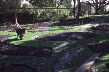 University of Melbourne, Burnley Campus Archives
Album - 35mm Colour slides, Rose Garden Construction, 1981
14 slides. no date. 1 slide labelled "Pruning Instruction", 2-3 Rose Garden construction Aug 81. 5-6 Tennis Court. 12. Pruning class. 13, 15, 16 Save Water Display. 14.Library. Some unidentified. Some scanned. Some poor quality.pruning, rose garden, rose garden construction, tennis court, save water, library -
Bialik College
Album (Item) - "The Visit" Bialik College, theatre production, 1998
1998 Theatre Production of "The Visit". Please contact [email protected] to request access to this record.theatre production, bialik college, judaism, 1990s -
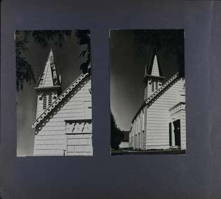 Glen Eira Historical Society
Album - Album page, Congregational Church, Grange Road, Circa 1972
This photograph is part of the Caulfield Historical Album 1972. This album was created in approximately 1972 as part of a project by the Caulfield Historical Society to assist in identifying buildings worthy of preservation. The album is related to a Survey the Caulfield Historical Society developed in collaboration with the National Trust of Australia (Victoria) and Caulfield City Council to identify historic buildings within the City of Caulfield that warranted the protection of a National Trust Classification. Principal photographer thought to be Trevor Hart, member of Caulfield Historical Society. Most photographs were taken between 1966-1972 with a small number of photographs being older and from unknown sources. All photographs are black and white except where stated, with 386 photographs over 198 pages. This church has since become the Greek Orthodox Church. From Victorian Heritage Database: Citation for Greek Orthodox Church HO84 https://vhd.heritagecouncil.vic.gov.au/places/43587 (as at 19/10/2020) The former Primitive Methodist, later Congregational, church at 152 Grange Road, Glen Huntly, is a small timber building, erected in 1885 (89?) in South Melbourne and relocated to Glenhuntly in 1909. It is a highly individual picturesque timber structure with distinctive spire and timber enrichment. It has aesthetic, historical and social significance. Its aesthetic value is derived from the choice of materials and picturesque Gothic Revival character showing American influence. Its historical value is derived from its survival as a rare example of a Primitive Methodist Church building whilst its social value hinges on its early roles as a place of worship for the Primitive Methodists in South Melbourne and the Congregationalists in Glenhuntly.Page 73 of Photograph Album with two photographs (both portrait) of front and side views of the spire of the Congregational Church on Grange RoadHand written: 73 [bottom left] trevor hart, congregational church, grange road, gothic revival, carnegie, glen huntly, glenhuntly, greek orthodox church, primitive methodist church, spire, timber buildings