Showing 55 items matching " bulletins of the geological survey of victoria"
-
 Bendigo Historical Society Inc.
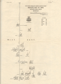
Map - HUSTLER'S REEF MINE - TRANSVERSE SECTION OF THE HUSTLER'S REEF MINE
Transverse Section of the Hustler's Reef Mine on the Hustler's Line of Reefs. Bulletin No 33, Plate No XVIII. Shows cross-cuts and their depth, different types of stone and geological features encountered. Drawing of poppet legs at the surface and Sill of Shaft 756.39 ft above Sea Level. Reference Table shows key to the different stone and geographical features encountered. Geographical Survey of Victoria. Signed by H A Whitelaw, Underground Survey Office, Bendigo, September 1913. Thompson's Reef is also mentioned on the map. mining, hustler's reef mine, transverse section of the hustler's reef mine, geological survey of victoria, h a whitelaw, underground survey office bendigo, thompson's reef. -
 Bendigo Historical Society Inc.
Map - HUSTLER'S CONSOLS MINE - TRANSVERSE SECTION OF THE HUSTLER'S CONSOLS MINE
Transverse Section of the Hustler's Consols Mine Bulletin No 33, Plate No XXXIII. Map shows poppet legs at the surface and Sill of Shaft 779.42 feet above Sea Level. Shows the different levels and their depths and the different stone and geographical features encountered. Has larger drawing of Section A - B. Geographical Survey of Victoria. Signed by H A Whitelaw, Underground Survey Office Bendigo, September 1913. mining, parish map, hustler's consols mine, transverse section of the hustler's consols mine, geological survey of victoria, underground survey office bendigo, h a whitelaw -
 Bendigo Historical Society Inc.
Map - HUSTLER'S REEF & HUSTLER'S REEF NO 1 MINES - PLAN OF THE HUSTLER'S REEF & HUSTLER'S REEF NO 1 MINES
Plan of the Hustler's Reef & Hustler's Reef No 1 Mines on the Hustler's Line of Reefs, Bendigo Bulletin No 33, Plate No XIV. No 8 connecting No 10 (Hustler's Reef), No 11 connecting No 13 (Hustler's Reef), No 13 (Hustler's Reef No 1) connecting No 15 (Hustler's Reef) and No 10 Hustler's Reef No 1 rise to Comet Mine. Map shows different levels in relation to the two shafts, the lines of the Hustler's Line of Reefs and the Lightning Hill Line of Reefs, the approximate Boundary of Lease and the Comet Co., the adjoining lease. Table on the left shows the levels and their depths of the two mines. Signed by H A Whitelaw, Underground Survey Office, Bendigo, September 1913. Geological Survey of Victoria emblem. mining, parish map, hustler's reef & hustler's reef no 1 mines, hustler's line of reefs lightning hill line of reefs, comet co., h a whitelaw, underground survey office bendigo, geological survey of victoria -
 Bendigo Historical Society Inc.
Map - HUSTLER'S REEF & HUSTLER'S REEF NO 1 MINES - LONGITUDINAL SECTION OF THE HUSTLER'S REEF & HUSTLER'S
Longitudinal Section of the Hustler's Reef & Hustler's Reef No 1 Mines on the Hustler's Line of Reef. Bulletin No 33, Plate No XX. Note - Plates 4, 8, 13, 20, 26 & 31 form a Longitudinal Section from Fortuna Hustler's to Hustler's Consols Mine. Geological Survey of Victoria emblem. Signed by H A Whitelaw, Underground Survey Office Bendigo, September 1913. Shows the two shafts with their levels and depths. Also shows geographical features and yields of gold and amalgam per ton. .mining, parish map, hustler's reef & hustler's reef no 1 mines, geographical survey of victoria, underground survey office bendigo, h a whitelaw -
 Bendigo Historical Society Inc.
Map - HUSTLER'S REEF & HUSTLER'S REEF NO 1 MINES - PLAN OF THE HUSTLER'S REEF & HUSTLER'S REEF NO 1 MINES
Plan of the Hustler's Reef & Hustler's Reef No 1 Mines on the Hustler's Line of Reefs Bulletin No 33, Plate No XVII. Two drawings with different levels on each for clarity. Shows depth and some geographical features. Geological Survey of Victoria emblem. Signed by H A Whitelaw Underground Survey Office Bendigo, September 1913. mining, parish map, hustler's reef & hustler's reef no 1 mines, hustler's line of reefs, geological survey of victoria, underground survey office bendigo, h a whitelaw -
 Bendigo Historical Society Inc.
Map - HUSTLER'S REEF & HUSTLER'S REEF NO 1 MINES - PLAN OF THE HUSTLER'S REEF & HUSTLER'S REEF NO 1 MINES
Plan of the Hustler's Reef & Hustler's Reef No 1 Mines on the Hustler's Line of Reefs Bulletin No 33, Plate No XV. Plan shows the two mines with depth of levels, geological features and levels in relation to the shaft. Geological Survey of Victoria emblem and signed by H A Whitelaw, Underground Survey Office Bendigo, September 1913. Note - The Lease Boundaries shown on this plan are only in their approximate relative positions to Nos 13, Intermediate and 14 Levels of the Hustler's Reef No 1 workings, and Nos 15, 16 and 17 Levels of the Hustler's Reef workings.mining, parish map, hustler's reef & hustler's reef no 1 mines, geological survey of victoria, underground survey office bendigo, h a whitelaw, hustler's line of reefs -
 Bendigo Historical Society Inc.
Map - HUSTLER'S REEF NO 1 MINE - EAST & WEST CROSS-CUTS OF THE HUSTLER'S REEF NO 1 MINE
Map showing the East & West Crosscuts, North & South of Shaft of the Hustler's Reef No 1 Mine on the Hustler's Line of Reefs Bulletin No 33, Plate No XXII. Drawing shows where the different levels are, the stone encountered and smaller drawings of other sections near the shaft. Also shows some geographical features. Signed by H A Whitelaw, Underground Survey Office Bendigo, September 1913. Geological Survey of Victoria emblem.mining, parish map, hustler's reef no 1 mine, geological survey of victoria, h a whitelaw, underground survey office bendigo, hustler's line of reefs -
 Bendigo Historical Society Inc.
Map - FORTUNA HUSTLER'S MINE - PLAN OF FORTUNA HUSTLER'S MINE
Map and plan of the Fortuna Hustler's Mine on the Hustler's Line of Reefs. Bulletin No 33, Plate No 1. Plan gives depth of the different levels. Bendigo Railway Station is on the map and also a number of the streets. Carpenter Street is called Cemetery Road. Also on the Hustler's Line of Reef is the Summer Hill Shaft. Shown is the Hustler's Royal Reserve No 2 Lease. Map has the Geological Survey of Victoria crest. It is signed by H Whit ? an Underground Survey Office Bendigo, September 1913. map, fortuna hustler's mine, hustler's royal reserve no 2 lease, summer hill shaft, hustler's line of reef -
 Bendigo Historical Society Inc.
Map - COMET MINE - LONGITUDINAL SECTION COMET MINE
Longitudinal section of the Comet Mine on the Hustler's Line of Reef Bulletin No 33, Plate No XXVI signed by H. S. Whitelaw, Underground Survey Office Bendigo, September 1913. Map shows datum lines, depths of levels, approximate boundaries and references to other plans. Note - Plates 4, 8, 13, 20, 26 and 31 form a Longitudinal Section from Fortuna Hustler's to Hustler's Consols Mine. Geological Survey of Victoriamining, parish map, hustler's line of reef, longitudinal section of comet mine bulletin no 33 plate no xxvi, h s whitelaw -
 Bendigo Historical Society Inc.
Map - COMET MINE - TRANSVERSE SECTION COMET MINE
Transverse section of the Comet Mine on the Hustler's Line of Reef Bulletin No 33, Plate No XXV signed by H. A. Whitdon, Underground Survey Office Bendigo September,1913. Map shows depth of the different levels, the type of stone and shaft about 2020 deep. A number of smaller drawings on the side. Reference explaining the different types of stone, etc. Geological Survey of Victoriamining, hustler's line of reefs, transverse section of comet mine bulletin no 33 plate no xxv, lightning hill line of reef -
 Bendigo Historical Society Inc.
Map - COMET MINE - PLAN OF COMET MINE
Plan of the Comet Mine on the Hustler's Line of Reefs Bulletin No 33, Plate No XXIII. Map shows depths, Lightning Hill Anticline, Hustler's Anticline and approximate Lease Boundary. Signed by H. S. Whitelaw, Underground Survey Office Bendigo, September 1913. United Hustler's & Redan Co and Hustler's Reef Co also named on map. Geological Survey of Victoriamining, hustler's line of reefs, comet line plan belletin no 33 plate no xxiii, lightning hill anticline, hustler's anticline, united hustler's & redan co, hustler's reef co, h s whitelaw -
 Bendigo Historical Society Inc.
Map - COMET MINE - PLAN OF COMET MINE
... Bulletin No 33 Plate No XXIV Geological Survey of Victoria Plan ...Plan of the Comet Mine on the Hustler's Line of Reefs Bulletin No 33, Plate No XXIV signed by H S Whitelaw, Underground Survey Office Bendigo, September 1913. Upper and Lower Levels and approximate boundaries shown. Depths shown.Geological Survey of Victoriamining, parish map, hustler's line of reefs, comet mine plan bulletin no 33 plate no xxiv -
 Bendigo Historical Society Inc.
Map - HUSTLERS LINE OF REEFS - LONGITUDINAL SECTION THROUGH THE SADDLE REEFS
Drawing with Longitudinal Section through the Saddle Reefs along portion of Hustler's Line of Reefs, Bendigo. Map shows the depth of the mines, reef numbers and Datum 700 ft above sea level. North and South is also noted on the map. Map signed by H. S, Whitelaw, Underground Survey Office, Bendigo, September 1913. Bulletin No 33, Plate No XXXIV. Bendigo Creek, Ironbark Creek and Long Gully are also noted. Mines are: Fortuna Hustlers, Hustler's Royal Reserve No 2 Main Shaft, Hustler's Royal Reserve No 2 Park Shaft, Royal Hustler's, Imperial Hustler's, Extended Hustler's Freehold, Great Extended Hustler's Tribute (Pups), Old Shaft, Great Extended Hustler's Reef No 2, Great Extended Hustler's Main Shaft, Old Shaft, Hustler's Reef, Hustler's Reef No 1, Comet, K. K., United Hustler's & Redan, Old Shaft and Hustler's Consols. Has Geological Survey of Victoria Crest and underneath is: H. Herman, Director, W. Dickson, Secretary for Mines, The Hon. J Drysdale Brown M L C. Minister of Mines.Geological Survey of Victoria Crestmining, hustler's reef maps, hustlers line of reefs, bendigo creek, royal hustler's, imperial hustler's, extended hustler's freehold, great extended hustler's tribute (pups), great extended hustler's reef no 2, great extended hustler's main shaft, hustler's reef, hustler's reef no 1, united hustler's & redan, old shaft and hustler's consols.h s whitelaw, underground survey office bendigo september 1913 -
 Bendigo Historical Society Inc.
Map - HUSTLER'S REEF NO 1 MINE - TRANSVERSE SECTION OF THE HUSTLER'S REEF NO 1 MINE
Map of a transverse Section of the Hustler's Reef No 1 Mine on the hustler's Line of Reefs Bulletin No 33, Plate No XXI. Map shows poppet legs at 801.07 feet above Sea Level and drawing of shaft with the different levels. Also shown are geological features and stone encountered. Geological Survey of Victoria emblem H Herman, Director, W Dickson, Secretary of Mines and The Hon. J. Drysdale Brown MLC Minister of Mines. Signed by H S Whitelaw, Underground Survey Office Bendigo, September 1913. This item has not been scanned or photographed.mining, parish map, hustler's reef no 1 mine, hustler's line of reefs, geological survey of victoria, underground survey office bendigo, h s whitelaw, h herman, w dickson, the hon j drysdale brown -
 Bendigo Historical Society Inc.
Map - HUSTLER'S ROYAL RESERVE NO 2 CO. - LONGITUDINAL SECTION OF THE HUSTLER'S ROYAL RESERVE NO 2 CO
Longitudinal Section of the Hustler's Royal Reserve No 2 Co. on the Hustler's Line of Reef Bulletin No 33, Plate No VIII. Note - Plates 4, 8, 13, 20, 26 & 31 form a Longitudinal Section from Fortuna Hustler's to Hustler's Consols Mine. Mines mentioned are the Hustler's Royal Reserve No 2 Main Shaft, Hustler's Royal Reserve No 2 Park Shaft, Royal Hustler's, Imperial Hustler's, Great Extended Hustler's Freehold and the Great Extended. Section shows depth of levels, datum lines and height of sill above sea level yield in oz. of gold. Geological Survey of Victoria emblem. H. Herman, Director, W. Dickson, Secretary for Mines and The Hon. J. Drysdale Brown MLC, Minister for Mines and signed by H S Whitelaw, Underground Survey Office Bendigo, September 1913. mining, parish map, hustler's royal reserve no 2, royal hustler's, imperial hustler's, great extended hustler's freehold, great extended, geological survey of victoria, underground survey office bendigo, h s whitelaw, h herman, w dickson, the hon j drysdale brown -
 Bendigo Historical Society Inc.
Map - HUSTLER'S ROYAL RESERVE NO 2 MINE - PLAN OF THE HUSTLER'S ROYAL RESERVE NO 2 MINE
Plan of the Hustler's Royal Reserve No 2 Mine Bulletin No 33, Plate No V. Plan shows the Hustler's Royal Reserve No 2 (Main Shaft), Hustler's Royal Reserve No 2 (Park Shaft.), the Royal Hustler's, the Imperial Hustler's and the Extended Hustler's Freehold on the Hustler's Line of Reefs. Also mentioned is the Lightning Hill Line of Reefs. Map shows some of the levels, approximate boundary of lease and the boundary of Lease No 8892 and 8897. There are also street names and the locations of jail, lagoons, Post Office, Rosalind Park and the State School, High School and Continuation School. Geological Survey of Victoria emblem. H. Herman Director, W. Dickson, Secretary of Mines and The Hon. J. Drysdale Brown MLC, Minister of Mines. Signed by zh Whitdan, Underground Survey Office, Bendigo, September 1913.mining, parish map, hustler's royal reserve no 2 mine, royal hustler's, imperial hustler's, extended hustler's freehold, geological survey of victoria, h herman, w dickson, the hon j drysdale brown, h whitdan, hustler's line of reefs, lightning hill line of reefs -
 Bendigo Historical Society Inc.
Map - HUSTLER'S ROYAL RESERVE NO 2 MINE - PLAN OF THE HUSTLER'S ROYAL RESERVE NO 2 MINE
Plan of the Hustler's Royal Reserve No 2 Mine on the Hustler's Line of Reefs Bulletin No 33, Plate No VI. Boundary of Leases No 8898 and 8897 shown. Various levels shown and some geographical features. Geological Survey of Victoria emblem. H . Harman, Director, W. Dickson, Secretary for Mines and The Hon. J. Drysdale Brown, Minister of Mines and signed by H Whitdon, Underground Survey Office, Bendigo, September 1913. mining, parish map, hustler's royal reserve no 2 mine, hustler's line of reefs, geological survey of victoria, h herman, w dickson, the hon j drysdale brown mlc -
 Bendigo Historical Society Inc.
Map - HUSTLER'S ROYAL RESERVE NO 2 CO - TRANSVERSE SECTION OF THE HUSTLER'S ROYAL RESERVE NO 2 CO
Transverse Section of the Hustler's Royal Reserve No 2 Co Mine on the Hustler's Line of Reef Bendigo, Bulletin No 33, Plate No VII. Section shows the poppet legs and the sill of Shaft at 707.65 ft above sea level, depth of levels, stone encountered and geological features. Geological Survey of Victoria emblem. H. Herman Director, W. Dickson Secretary of Mines and The Hon. J. Drysdale Brown MLC, Minister of Mines. Signed by H S Whitelaw, Underground Survey Office Bendigo, September 1913. mining, parish map, hustler's royal reserve no 2 co, h s whitelaw, undergrou;nd survey office bendigo, geological survey of victoria, h herman, w dickson, the hon. j drysdale brown mlc -
 Bendigo Historical Society Inc.
Map - HUSTLER'S ROYAL RESERVE NO 2 (PARK SHAFT.) - TRANSVERSE SECTION OF THE HUSTLER'S ROYAL RESERVE NO 2
Transverse section of the Hustler's Royal Reserve, No 2 (Park Shaft.) on the Hustler's Line of Reef. Bulletin No 33, Plate No IX. Section shows poppet legs and sill of shaft at 755.70 ft above sea level, depth of levels, type of stone encountered including lava and geological features. Geological Survey of Victoria emblem and beneath it H. Herman, Director, W. Dickson, Secretary of Mines and The Hon. J. Drysdale Brown MLC Minister of Mines and signed by H S Whitelaw, Underground Survey Office, Bendigo September 1913.mining, parish map, hustler's royal reserve no 2 (park shaft.), h s whitelaw, underground survey office bendigo, geological survey of victoria, h herman, w dickson, the hon j drysdale brown mlc, hustler's line of reef -
 Bendigo Historical Society Inc.
Map - UNITED HUSTLER'S & REDAN & K. K. MINES - PLAN OF THE UNITED HUSTLER'S & REDAN & K. K. MINES
Plan of the United Hustler's & Redan & K. K. Mines Bulletin No 33 Plate No XXXI. Shows depth of levels, Probable positions of reefs and natural surface with the poppet legs at the two shafts. Sill of shaft of the K. K. Mine 773.56 ft above Sea Level and sill of shaft of the United Hustler's & Redan Mine 745.62 above Sea Level. Also mentioned is the average amount of gold obtained per ton. Note on the top of page - Plates 4, 8, 13, 20, 26 & 31 form a Longitudinal Section from Fortuna Hustler's to Hustler's Consols Mine. Geological Survey of Victoria emblem and signed by H S Whitelaw, Underground Survey Office, Bendigo, September 1913. mining, parish map, united hustler's & redan & k. k. mines, geological survey of victoria, h s whitelaw, underground survey office bendigo -
 Bendigo Historical Society Inc.
Map - UNITED HUSTLER'S & REDAN & K. K. MINES - PLAN OF UNITED HUSTLER'S & REDAN & K. K. MINES
Plan of the United Hustler's & Redan & K. K. Mines on the Hustler's Line of Reefs Bulletin No 33 Plate No XXVII. Plan shows depth of levels, Long Gully, Hustler's Line of Reefs, Lightning Hill Line of Reefs and approximate Boundary of Lease. Also mentions Comet Co. Geological Survey of Victoria emblem and signed by H S Whitelaw, Underground Survey Office Bendigo September 1913.mining, parish map, united hustler's & redan & k. k. mines, long gully, hustler's line of reefs, lightning hill line of reefs, comet co, h s whitelaw, geological survey of victoria, underground survey office -
 Bendigo Historical Society Inc.
Map - UNITED HUSTLER'S & REDAN & K. K. MINES - PLAN OF UNITED HUSTLER'S & REDAN & K. K. MINES
Plan of the United Hustler's & Redan & K. K. Mines on the Hustler's Line of Reefs Bulletin No 33 Plate No XXVIII. Plan shows depth of levels, stone encountered and some geological features. Geological Survey of Victoria emblem and signed by H S Whitelaw, Underground Survey Office Bendigo, September 1913. mining, parish map, united hustler's & redan & k. k. mines, united hustler's and redan shaft, k. k. shaft, h s whitelaw -
 Bendigo Historical Society Inc.
Map - UNITED HUSTLER'S & REDAN MINE - TRANSVERSE SECTION UNITED HUSTLER'S & REDAN MINE
Transverse Section of the United Hustler's & Redan Mine on the Hustler's Line of Reefs Bulletin No 33, Plate No XXIX. Map has drawing of poppet legs on the surface, depth of levels, type of stone encountered and some geological features. Sill of shaft 745.62 ft above sea level. Map has Geological Survey of Victoria emblem and signed by H S Whitelaw, Underground Survey Office Bendigo, 'September 1913. mining, parish map, united hustler's & redan mine, hustler's line of reef, geological survey of victoria, h s whitelaw -
 Bendigo Historical Society Inc.
Map - UNITED HUSTLER'S & REDAN MINE - TRANSVERSE SECTIONS N & S OF SHAFT UNITED HUSTLER'S & REDAN MINE
Transverse Sections N & S of Shaft United Hustler's & Redan Mine on the Hustler's Line of Reef Bulletin No 33, Plate No XXX. Map shows some of the stone encountered on the levels and depth. Geological Survey of Victoria emblem and signed by H A Whitdan, Underground Survey Office Bendigo, September 1913.mining, parish map, united hustler's & redan mine, transverse sections n & s of shaft united hustler's & redan mine, hustler's line of reef -
 Bendigo Historical Society Inc.
Map - K. K. MINE - TRANSVERSE SECTION K. K. MINE
Transverse Section of the K. K. Mine on the Hustler's Line of Reefs, Bulletin No 33, Plate No XXXII. Map shows the different levels and their depth. Also, the different types of stone encountered and geological features such as spurs and faults. Has drawing of the poppet legs at the top of the shaft and sill of shaft 773.56 ft above sea level. Map has Geological Survey of Victoria crest and signed by H S Whitelaw, Underground Survey Office Bendigo, September 1913. miners, fortuna hustler's mine, transverse section of k. k. mine, hustler's line of reefs, geological survey of victoria, h s whitelaw